Trnava Region
Encyclopedia

Regions of Slovakia
Since 1949 , Slovakia has been divided into a number of kraje . Their number, borders and functions have been changed several times. There are currently eight regions of Slovakia and they correspond to the EU's NUTS 3 level of local administrative units. Each kraj consists of okresy...
.
Geography
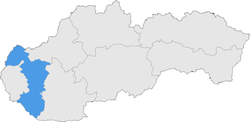
It is located in the middlewest part of SlovakiaSlovakia
The Slovak Republic is a landlocked state in Central Europe. It has a population of over five million and an area of about . Slovakia is bordered by the Czech Republic and Austria to the west, Poland to the north, Ukraine to the east and Hungary to the south...
and forms a territorial band between the Bratislava Region
Bratislava Region
The Bratislava Region is one of the administrative regions of Slovakia. Its capital is Bratislava. It is the smallest of the eight regions of Slovakia.-Geography:...
and the rest of Slovakia, between Austria
Austria
Austria , officially the Republic of Austria , is a landlocked country of roughly 8.4 million people in Central Europe. It is bordered by the Czech Republic and Germany to the north, Slovakia and Hungary to the east, Slovenia and Italy to the south, and Switzerland and Liechtenstein to the...
n and Czech
Czech Republic
The Czech Republic is a landlocked country in Central Europe. The country is bordered by Poland to the northeast, Slovakia to the east, Austria to the south, and Germany to the west and northwest....
borders in the north and Hungarian
Hungary
Hungary , officially the Republic of Hungary , is a landlocked country in Central Europe. It is situated in the Carpathian Basin and is bordered by Slovakia to the north, Ukraine and Romania to the east, Serbia and Croatia to the south, Slovenia to the southwest and Austria to the west. The...
border in the south. The part north of the Little Carpathians
Little Carpathians
The Little Carpathians are a low, about 100 km long, mountain range, part of the Carpathian Mountains. The mountains are situated in Western Slovakia, covering the area from Bratislava to Nové Mesto nad Váhom, a very small part called Hundsheimer Berge is situated south of Devín Gate in...
is part of the Záhorie
Záhorie
Záhorie is a region in western Slovakia bordered by the Little Carpathians in the east and the Morava River in the west. Although not an administrative region in its own right, it is one of the 21 official tourism regions in Slovakia...
Lowland, with its two subdivisions: hilly Chvojnická pahorkatina and flat Borská nížina. In addition to these, the Myjava Hills
Myjava Hills
The Myjava Hills is an area of hills in western Slovakia, rugged highlands along the Myjava River composed of Carpathian flysch...
and the White Carpathians
White Carpathians
The White Carpathians is the westernmost mountain range of the Carpathian Mountains.They are part of the Slovak-Moravian Carpathians, stretching from the Váh river and the Little Carpathians in the south along the border between the Czech Republic and Slovakia to the Morava and the Javorníky range...
reach into the area. The fertile Danubian Lowland
Danubian Lowland
The Danubian Lowland or Danube Lowland is the name of the part of Little Alföld situated in Slovakia, located between the Danube, the Little Carpathians and all other parts of the Western Carpathians....
is located south of the Little Carpathians, again with two subdivisions: the Danubian Flat
Danubian Flat
The Danubian Flat , also translated as Danubian Plain, is the south-western, more flat, part of the Danubian Lowland in Slovakia.The border with the Danubian Hills runs approx...
in the south, containing river island of Žitný ostrov
Žitný ostrov
Žitný ostrov, also called Veľký Žitný ostrov to differentiate it from Malý Žitný ostrov , is a river island in southwestern Slovakia, extending from Bratislava to Komárno. It lies between the Danube and its tributary Little Danube and is a major part of the Danubian Flat...
(Rye Island) and the Danubian Hills
Danubian Hills
The Danubian Hills , also translated as Danubian Upland, is the north-eastern, more mountain-like, part of the Danubian Lowland in Slovakia....
in the north, where it also borders the Považský Inovec
Považský Inovec
Považský Inovec is a mountain range in western Slovakia, named after the Váh river. It is 48 km long and 15-25 km wide mountain range...
range app. on the line Hlohovec - Piešťany
Pieštany
Piešťany is a town in Slovakia. It is located in the western part of the country within the Trnava Region and is the seat of its own district. It is the biggest and best known spa town in Slovakia and has around 30,000 inhabitants.-History:...
- border with the Trenčín Region. Major rivers are the Danube
Danube
The Danube is a river in the Central Europe and the Europe's second longest river after the Volga. It is classified as an international waterway....
on the Hungarian border, with part of the Gabčíkovo Dam, Little Danube
Little Danube
The Little Danube is a branch of the river Danube in Slovakia.It splits from the main river near Bratislava, and flows more or less parallel to the Danube until it flows into the river Váh in Kolárovo...
, which creates with Danube the island of Žitný ostrov, Váh
Váh
The Váh is the longest river in entire Slovakia. A left tributary of the Danube river, the Váh is 406 km long, including its Čierny Váh branch...
in the east, Dudváh
Dudváh
Dudváh is a lowland river in western Slovakia. It is 97 km long, with a basin of 1,507 km², and with a flow of 1.3 m³/s near the village of Siladice. Its source is located in the Čachtice Little Carpathians, and it mostly runs in parallel to the Váh river. Dudváh flows into the old branch of the...
in the centre, and Morava River in the north-west, along the Austrian and Czech borders. The region borders: Austrian Lower Austria
Lower Austria
Lower Austria is the northeasternmost state of the nine states in Austria. The capital of Lower Austria since 1986 is Sankt Pölten, the most recently designated capital town in Austria. The capital of Lower Austria had formerly been Vienna, even though Vienna is not officially part of Lower Austria...
and Czech South Moravian Region
South Moravian Region
South Moravian Region is an administrative unit of the Czech Republic, located in the south-western part of its historical region of Moravia, with exception of Jobova Lhota, that belongs to Bohemia. Its capital is Brno the 2nd largest city of the Czech Republic. The region is famous for its wine...
in the north-west, Trenčín Region
Trencín Region
The Trenčín Region is one of the eight Slovak administrative regions. It consists of 9 districts .-Geography:It is located in the north-western Slovakia, has an area of 4,502 km² and a population of 600,386 . The Danubian Lowland reaches the region to Nové Mesto nad Váhom and Partizánske areas...
in the north, Nitra Region
Nitra Region
The Nitra Region is one of the administrative regions of Slovakia.-Geography:This region with a long history is situated in the southwest of Slovakia, mostly in the eastern part of the Danubian Lowland. It is divided into two sub-units: the Danubian Flat in the south-west, with eastern part of the...
in the east, Hungarian Győr-Moson-Sopron
Gyor-Moson-Sopron
Győr-Moson-Sopron is the name of an administrative county in north-western Hungary, on the border with Slovakia and Austria. It shares borders with the Hungarian counties Komárom-Esztergom, Veszprém and Vas. The capital of Győr-Moson-Sopron county is Győr...
county in the south and Bratislava Region
Bratislava Region
The Bratislava Region is one of the administrative regions of Slovakia. Its capital is Bratislava. It is the smallest of the eight regions of Slovakia.-Geography:...
in the west.
Demographics
In terms of population, the region is smallest of all Slovak regions. However, the population density is 133 inhabitants per km², what is more than Slovak average (110 per km²). Largest towns are TrnavaTrnava
Trnava is a city in western Slovakia, 47 km to the north-east of Bratislava, on the Trnávka river. It is the capital of a kraj and of an okres . It was the seat of a Roman Catholic archbishopric . The city has a historic center...
, Piešťany
Pieštany
Piešťany is a town in Slovakia. It is located in the western part of the country within the Trnava Region and is the seat of its own district. It is the biggest and best known spa town in Slovakia and has around 30,000 inhabitants.-History:...
, Hlohovec, Dunajská Streda
Dunajská Streda
Dunajská Streda is a town in southern Slovakia . Dunajská Streda is the most important town of the Žitný ostrov region. It has a Hungarian ethnic majority and its population is 23,562 -Name:...
and Sereď
Sered
Sereď is a town in southern Slovak Republic near Trnava, on the right bank of the Váh River on the Danubian Lowland. It has аpproximately 17,000 inhabitants.It has a hotel, cinema, culture house, many restaurants and confectioner's shops.-Geography:...
. The level of urbanization is around 49%, represented by inhabitants living in 16 towns. According to the 2001 census, the region had 551,003 inhabitants, with Slovaks
Slovaks
The Slovaks, Slovak people, or Slovakians are a West Slavic people that primarily inhabit Slovakia and speak the Slovak language, which is closely related to the Czech language.Most Slovaks today live within the borders of the independent Slovakia...
forming a majority (73.9%), but there is a significant Hungarian minority in the south (23.7%), forming a majority in the Dunajská Streda District (87%) and are notably represented in the Galanta District (41%). Other minorities are the Czechs
Czech people
Czechs, or Czech people are a western Slavic people of Central Europe, living predominantly in the Czech Republic. Small populations of Czechs also live in Slovakia, Austria, the United States, the United Kingdom, Chile, Argentina, Canada, Germany, Russia and other countries...
and Roma (<1%).
List of districts
The Trnava Region consists of 7 districts:- Trnava DistrictTrnava DistrictTrnava District is adistrict in the Trnava Region of western Slovakia.Until 1918, the district was mostly part of the Hungarian countyof Pozsony, apart from Bučany in the east which formed part of Nyitra County.-Municipalities:*Biely Kostol*Bíňovce...
- Dunajská Streda DistrictDunajská Streda DistrictDunajská Streda District is a district in the Trnava Region of western Slovakia....
- Galanta DistrictGalanta DistrictGalanta District is adistrict inthe Trnava Region of western Slovakia.Until 1918, the district was mostly part of theHungarian countyof Pozsony , apart from a smallarea in the east, which formed part ofNyitra county....
- Piešťany DistrictPieštany DistrictPiešťany District is a district inthe Trnava Region of western Slovakia, with the town of Piešťany being as its seat. Until 1918, the district was part of the Hungarian county of Nitra.- Geography :...
- Senica DistrictSenica DistrictSenica District is adistrict inthe Trnava Region of western Slovakia.Until 1918, the district was mostly part of theHungarian countyof Nitra, with a small portionforming part of the county of Pressburg.-Municipalities:...
- Hlohovec DistrictHlohovec DistrictHlohovec District is adistrict inthe Trnava Region of western Slovakia.Until 1918, the district was part of theHungarian countyof Nitra.-Municipalities:*Bojničky*Červeník*Dolné Otrokovce*Dolné Trhovište*Dolné Zelenice...
- Skalica DistrictSkalica DistrictSkalica District is adistrict inthe Trnava Region of western Slovakia.Until 1918, the district was part of theHungarian countyof Nitra.-Municipalities:*Brodské*Dubovce*Chropov*Gbely*Holíč*Kátov*Kopčany...
List of municipalities and towns
There are 249 municipalities, of which 16 are towns (in bold).External links
- Trnavský samosprávny kraj Official website

