
Transport in Brighton and Hove
Encyclopedia
The public transport in Brighton and Hove (on the south coast of England
) has a history dating back to 1840. Today it has a major railway station, an extensive bus service, a large number of taxis, coach services, a Bus Rapid Transit
system under construction and in the past it has had trolley buses, ferries, trams, auto rickshaws and hydrofoil services.
is located just outside of Brighton and Hove, providing general aviation and some commercial aviation. The city is also not far away from London Gatwick Airport
.
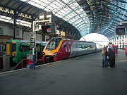
 Brighton railway station
is the most important station in Sussex, where lines from the north, west and east terminate.
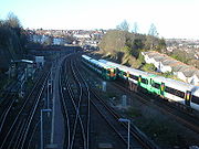
Other currently-operating railway Stations in Brighton and Hove are:
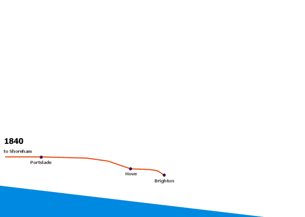
Brighton station opened in 1840 by the London and Brighton Railway
, which also established one of the first railway-owned locomotive works
(now the New England Quarter
). The station provides fast and frequent connections to Gatwick Airport
, several London main-line stations, Luton Airport
and Bedford and also to Ashford International.
Regular services also operate via Bristol
to Wales
.
The express London Victoria service takes 51 minutes today, compared with one hour in 1910, 80 minutes in 1859 and up to two hours when the service began in 1841. This line's initial permanent way will soon form a walkable Greenway from the original platform location (below the current station, off Trafalgar Street) through the New England Quarter
development and over the 1841 bridge over New England Road.
In addition to the main line to London
, Brighton railway station has connections to Shoreham-by-Sea
(1840) via the West Coastway Line
, and Lewes
(1846) by the East Coastway Line
. The original Hove Station (1840–80 then 1905–32 called Holland Road) was located at the junction of Davigdor, Holland and Cromwell Roads. The current Hove station site opened as Cliftonville in 1865 and was joined to the London main line in 1879 by the Cliftonville tunnel.
Other stations within Brighton, with opening dates, are London Road station (1877), which is located between Ditching Rise and Springfield Road at some distance from London Road itself; Moulsecoomb railway station
(1980); and Falmer railway station
(1846; moved to its present site nearer Brighton in 1890), all on the East Coastway Line. On the Brighton Main Line, non express London trains stop at Preston Park railway station
(opened as Preston in 1869).
 ]
]
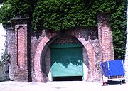
 From 1869 until 1932 (and for freight until 1971) there was a line (view map) to the Kemptown
area of Brighton: Lewes Road railway station (actually on Mayo Road 1873–1932), Hartington Road Halt (1906–11) and the terminus, Kemp Town railway station and goods yard. The entire line is closed and only the tunnel under Elm Grove remains (can be seen from the Freshfield Industrial Estate and below the Elm Grove Primary School), and the commemorative locomotive sculpture on the Bingo Hall on Eastern Road (corner of Park Street). The Hughes Road Industrial Estate, Freshfield Industrial Estate, Enterprise Point and Bonchurch Road Park now occupy the track alignment, and the bricks from (and alignment of) the Lewes Road viaduct were reused for the Sainsbury's store at the Vogue Gyratory, which has retained a viaduct theme.
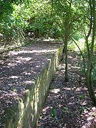
There was formerly a branch line from Aldrington station
(then Dyke Junction), to Devil's Dyke
(view map). This ran between 1887 and 1939 and the old track is now used as a footpath and cycle track north of the Hangleton
estate as far as the clubhouse of the Devil's Dyke golf-course. Briefly at the beginning of the 20th century a steep grade funicular railway took visitors to the bottom of the dyke itself and a cable car spanned the space above it. Remnants of the concrete piers used to support the cableway can still be seen on opposite sides of the dyke. There was also a station, Rowan Halt
near Rowan Avenue from 1932–38 and a stop on the city border at the Golf Club Halt
.
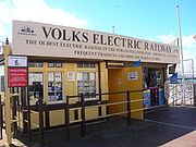 Volk's Electric Railway
, created in 1883, runs along the inland edge of the beach from the Palace Pier to Black Rock. It is the world's oldest operating electric railway.
Between 1894 and 1901 there was another electric railway, also created by Magnus Volk
: the daddy long legs
used tracks laid out under the sea, avoiding the need to build a viaduct. The carriage had tall iron legs and carried the passengers above the waves. This ran from specially constructed piers at the Banjo Groyne to Rottingdean
. It was never able to withstand stormy weather, and after several collapses and reconstructions, and final insurmountable problem of changes to the sea defences, it was abandoned. Remnants of its concrete foundations can sometimes be seen along the route at low tide between the Marina and Rottingdean.

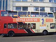
 Brighton & Hove Bus and Coach Company, a subsidiary of the Go-Ahead Group
, operates a local bus service with approximately 300 buses. In 1997, Brighton & Hove absorbed the former municipal operator, "Brighton Blue Buses" whose history dated back to the 1880s. The council and bus company run a. There is a regular half-hour all-night bus service on routes N7 and N25, and late night journeys aimed at clubbers
on N29, N69, N98 and N99. Most buses bear names of famous local people.
The Brighton & Hove Bus company run the following popular "metro routes":
The other routes include the 2 Shoreham
to Rottingdean
; 6 Brighton railway station
to Portslade
Asda; 12/13 to Eastbourne
; 14 to Peacehaven
and Newhaven
; 16/66 shopping route serving Hangleton
and Portslade
; 20 to Steyning
; 21 Marina to Brighton Station; 22 to Woodingdean
; 23 Marina to Universities; 24 to Hollingbury
via Coldean
; 26 to Hollingbury
via Ditchling Road; 27 Westdene/Hangleton to Saltdean
; 28 to Ringmer
; 29 to Uckfield
and Tunbridge Wells; 37/38 Meadowview to Bristol Estate; 46 Hollingbury to Southwick; 50 to Hollingdean; 77 to Devil's Dyke
and 81 Goldstone Valley to Queen's Park and Open Market.
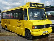
The Big Lemon
(yellow vehicles) bus service started in 2006. It operates one route (42) between the city centre and the Falmer Universities campuses using 100% recycled bio-fuel during term time.
The Stagecoach Group
(through its Stagecoach South
division) operates a frequent service (route 700
) westwards along the south coast under the "Coastliner" brand name as well as an hourly service 17 from Brighton to Horsham
.
Countryliner Coaches
operate two complementary hourly services, the 40 from
Churchill Square to the West Sussex village of Cuckfield
; and the 40X between Royal Sussex County Hospital
and Princess Royal Hospital, Haywards Heath
. Together these give a half-hourly frequency on the core section of the route from Brighton Old Steine to Hassocks
, Burgess Hill
town centre and the Worlds End district of Burgess Hill, and Haywards Heath
.
Metrobus, another Go-Ahead company runs daily services from Churchill Square to Crawley
.
The Council is also involved in a "door-to-door" bus link scheme covering the whole city. A company called Community Transport (Brighton, Hove and Area) Ltd, incorporated in 1991, operates the service on behalf of the Council. Specially adapted buses with passenger lifts or ramps for wheelchairs are used at all times, and journeys can be booked by telephone.
One line will then visit:
The other will visit:
(a £40 million extension to Shoreham and Newhaven has been pencilled in for 2015).
From Brighton Railway Station, the Rapid Transport system will use:
¹ on existing roads
² in bus lanes (with camera enforcement)
³ newly constructed roadway
and Hove
taxis pre-dates the conjoining of the two towns into one city.
Brighton and Hove City Cabs (01273 205205), was established in 1962 and operates a fleet of approximately 180 vehicles and 250 licensed drivers.
Brighton and Hove Radio Cabs Ltd (01273 204060) are another large privately-owned firm, established in 1964 and based in the Seven Dials
area of Brighton. Their present fleet comprises approximately 180 vehicles.
414141 Carcabs Ltd, trading as Carcabs (01273 414141), are based in Portslade
and operate throughout the Brighton and Hove city area and further west.
The oldest taxi company in the city is Streamline Taxis (01273 747474 & 202020), formed in 1936 as a co-operative
association. Its members were individual vehicle proprietors, who operated independently but for whom an association of this type would be mutually beneficial. Each member paid a fee to join the association and a regular subscription fee to cover running and administrative costs. The association was governed by a committee of elected members. This structure is still in place today, and the association now comprises approximately 170 vehicles and 350 licensed drivers.
The city's has major taxi ranks in East Street in the Lanes
, at the Level in central Brighton, at Brunswick
Place in Hove, and at both main railway stations, as well as a number of other ranks.
operates coach services from Pool Valley coach station, near the Palace Pier
. Coaches operate to London Victoria, Gatwick Airport, Eastbourne, Helston, Southampton, Exeter, Plymouth, Heathrow Airport, Stansted Airport.
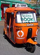 During summer months in recent years, a network of auto rickshaw
s operated (by Tuctuc Ltd
) in Brighton and Hove. They operated like a bus service, following set routes and only intended to pick up at dedicated stops, and there was also a "dial-a-ride" taxi-like option. The routes ran from Brighton Marina
to Hove Town Hall via Brighton railway station.
The auto rickshaws, came in two sizes, were each painted in distinct styles, and powered by compressed natural gas
.
Tuctuc Ltd have now ceased operating.
 The first tramway in the Brighton area was the Brighton and Shoreham Tramway, which at its fullest extent ran from a terminus in Southdown Road, Shoreham
to Westbourne Villas in Hove
, on the former boundary between Hove and Portslade. The tramway never penetrated Hove, although a connecting horse-bus (route 112, operated by the Brighton and Preston United Omnibus Company) was available from the Westbourne Villas terminus. Construction took place in 1883 and 1884; the route was opened throughout on 3 July 1884, initially with steam-driven trams. After this proved unsuccessful, other methods of propulsion were tried (including, in 1887, an early battery-powered locomotive) until horse power took over in 1893. The British Electric Traction
company took over the operations in 1898, but was unable to agree with any of the local authorities on a strategy for electrification. The tramway was therefore horse-drawn until the end, on 6 June 1913.
Brighton Corporation Tramways operated an extensive network of routes in the first four decades of the 20th century. The first route to operate, from 25 November 1901, ran from the main terminus at the Aquarium (outside Brighton Pier
) to Lewes Road, a major route to the north-east; other routes were quickly established, so that by 1904 its full extent had been established. The routes were as follows:
Routes B and D formed a loop that took approximately 30 minutes to navigate. Route B ran clockwise (via Beaconsfield Road first, then returning via Ditchling Road). A depot serving the whole network was established on Lewes Road, a short distance before the terminus; Brighton & Hove now uses the building as its main depot.
Improvements in motor bus and trolleybus
technology meant that by the 1930s, the tram system found it difficult to compete, and most of the network was replaced by the Brighton trolleybus system
or motor bus routes in 1939. The last tram arrived at Lewes Road depot in the early hours of 1 September 1939 - at about the same time Germany invaded Poland, and ignited the conflict that became World War II
.
Distinctive timber shelters were built at many stops in the early years of the network. Some of these are still standing today. The remains of the shelter on Lewes Road at the Vogue Gyratory can be seen in the Kwik-Fit
garage. Also some of the rails still exist beneath the road surfaces, since it would have been too costly to dig them out
England
England is a country that is part of the United Kingdom. It shares land borders with Scotland to the north and Wales to the west; the Irish Sea is to the north west, the Celtic Sea to the south west, with the North Sea to the east and the English Channel to the south separating it from continental...
) has a history dating back to 1840. Today it has a major railway station, an extensive bus service, a large number of taxis, coach services, a Bus Rapid Transit
Bus rapid transit
Bus rapid transit is a term applied to a variety of public transportation systems using buses to provide faster, more efficient service than an ordinary bus line. Often this is achieved by making improvements to existing infrastructure, vehicles and scheduling...
system under construction and in the past it has had trolley buses, ferries, trams, auto rickshaws and hydrofoil services.
Air
Shoreham AirportShoreham Airport
- Sussex Police Air Operations Unit :The Sussex Police Air Operations Unit is headquartered at Shoreham Airport. The unit has been equipped since February 2000 with a MD Explorer, registered as "G-SUSX". The unit is headed by a Police Inspector, assisted by a Police Sergeant and two Police...
is located just outside of Brighton and Hove, providing general aviation and some commercial aviation. The city is also not far away from London Gatwick Airport
London Gatwick Airport
Gatwick Airport is located 3.1 miles north of the centre of Crawley, West Sussex, and south of Central London. Previously known as London Gatwick,In 2010, the name changed from London Gatwick Airport to Gatwick Airport...
.
Rail
Brighton railway station
Brighton railway station is the principal railway station in the city of Brighton and Hove, on the south coast of England. The station master is Mark Epsom...
is the most important station in Sussex, where lines from the north, west and east terminate.
Other currently-operating railway Stations in Brighton and Hove are:
- North of Brighton: Preston ParkPreston Park railway stationPreston Park railway station serves the northern suburban areas of Brighton in East Sussex, England. It is on the Brighton Main Line and Thameslink 2 km north of Brighton railway station, and train services are provided by Southern and First Capital Connect...
. - West of Brighton: HoveHove railway stationHove railway station is in Hove in the county of East Sussex, England. The station and the majority of trains serving it are operated by Southern. The only other operator is First Great Western, who provide a limited number of services each day to Wales and the West Country. However Gatwick Express...
; AldringtonAldrington railway stationAldrington railway station, sometimes known by its former names of Aldrington Halt and Dyke Junction, is a railway station in Hove, in East Sussex, England...
; PortsladePortslade railway stationPortslade railway station is a railway station serving the town of Portslade-by-Sea in East Sussex, but located on the western fringes of the village of Aldrington ....
; FishersgateFishersgate railway stationFishersgate railway station is a railway station in Sussex, serving the Southern Cross area between Portslade and Southwick at the western edge of the Brighton and Hove conurbation.-History:...
(on the border with West Sussex). - East of Brighton: London RoadLondon Road (Brighton) railway stationLondon Road Railway Station is in Brighton, East Sussex, England. Train services from the station are provided by Southern, and the station is on the East Coastway Line.- History :...
; MoulsecoombMoulsecoomb railway stationMoulsecoomb Railway Station serves Moulsecoomb, a suburb of Brighton in East Sussex, England. Train services from the station are provided by Southern, and the station is on the East Coastway Line....
; FalmerFalmer railway stationFalmer Railway Station is operated by Southern and lies on the East Coastway Line.The station serves the village of Falmer as well as the University of Sussex campus and the University of Brighton Falmer Campus. It also serves Falmer Stadium, the new home of Brighton & Hove Albion F.C....
.
Brighton station opened in 1840 by the London and Brighton Railway
London and Brighton Railway
The London and Brighton Railway was a railway company in England which was incorporated in 1837 and survived until 1846. Its railway runs from a junction with the London & Croydon Railway at Norwood - which gives it access from London Bridge, just south of the River Thames in central London...
, which also established one of the first railway-owned locomotive works
Brighton railway works
Brighton railway works was one of the earliest railway-owned locomotive repair works, founded in 1840 by the London and Brighton Railway in Brighton, England, and thus pre-dating the more famous railway works at Crewe, Doncaster and Swindon...
(now the New England Quarter
New England Quarter
The New England Quarter is a mixed-use development in the city of Brighton and Hove, England. It was built between 2004 and 2008 on the largest brownfield site in the city, adjacent to Brighton railway station...
). The station provides fast and frequent connections to Gatwick Airport
London Gatwick Airport
Gatwick Airport is located 3.1 miles north of the centre of Crawley, West Sussex, and south of Central London. Previously known as London Gatwick,In 2010, the name changed from London Gatwick Airport to Gatwick Airport...
, several London main-line stations, Luton Airport
London Luton Airport
London Luton Airport is an international airport located east of the town centre in the Borough of Luton in Bedfordshire, England and is north of Central London. The airport is from Junction 10a of the M1 motorway...
and Bedford and also to Ashford International.
Regular services also operate via Bristol
Bristol
Bristol is a city, unitary authority area and ceremonial county in South West England, with an estimated population of 433,100 for the unitary authority in 2009, and a surrounding Larger Urban Zone with an estimated 1,070,000 residents in 2007...
to Wales
Wales
Wales is a country that is part of the United Kingdom and the island of Great Britain, bordered by England to its east and the Atlantic Ocean and Irish Sea to its west. It has a population of three million, and a total area of 20,779 km²...
.
The express London Victoria service takes 51 minutes today, compared with one hour in 1910, 80 minutes in 1859 and up to two hours when the service began in 1841. This line's initial permanent way will soon form a walkable Greenway from the original platform location (below the current station, off Trafalgar Street) through the New England Quarter
New England Quarter
The New England Quarter is a mixed-use development in the city of Brighton and Hove, England. It was built between 2004 and 2008 on the largest brownfield site in the city, adjacent to Brighton railway station...
development and over the 1841 bridge over New England Road.
In addition to the main line to London
Brighton Main Line
The Brighton Main Line is a British railway line from London Victoria and London Bridge to Brighton. It is about 50 miles long, and is electrified throughout. Trains are operated by Southern, First Capital Connect, and Gatwick Express, now part of Southern.-Original proposals:There were no fewer...
, Brighton railway station has connections to Shoreham-by-Sea
Shoreham-by-Sea
Shoreham-by-Sea is a small town, port and seaside resort in West Sussex, England. Shoreham-by-Sea railway station is located less than a mile from the town centre and London Gatwick Airport is away...
(1840) via the West Coastway Line
West Coastway Line
The West Coastway Line is a railway line in England, along the south coast of West Sussex and Hampshire, between Brighton and Southampton, plus the short branches to Littlehampton and Bognor Regis....
, and Lewes
Lewes
Lewes is the county town of East Sussex, England and historically of all of Sussex. It is a civil parish and is the centre of the Lewes local government district. The settlement has a history as a bridging point and as a market town, and today as a communications hub and tourist-oriented town...
(1846) by the East Coastway Line
East Coastway Line
East Coastway is the name used by the train operating company, Southern , for the routes it operates along the south coast of Sussex and Kent to the east of Brighton, England. Those to the West of Brighton are named the West Coastway Line...
. The original Hove Station (1840–80 then 1905–32 called Holland Road) was located at the junction of Davigdor, Holland and Cromwell Roads. The current Hove station site opened as Cliftonville in 1865 and was joined to the London main line in 1879 by the Cliftonville tunnel.
Other stations within Brighton, with opening dates, are London Road station (1877), which is located between Ditching Rise and Springfield Road at some distance from London Road itself; Moulsecoomb railway station
Moulsecoomb railway station
Moulsecoomb Railway Station serves Moulsecoomb, a suburb of Brighton in East Sussex, England. Train services from the station are provided by Southern, and the station is on the East Coastway Line....
(1980); and Falmer railway station
Falmer railway station
Falmer Railway Station is operated by Southern and lies on the East Coastway Line.The station serves the village of Falmer as well as the University of Sussex campus and the University of Brighton Falmer Campus. It also serves Falmer Stadium, the new home of Brighton & Hove Albion F.C....
(1846; moved to its present site nearer Brighton in 1890), all on the East Coastway Line. On the Brighton Main Line, non express London trains stop at Preston Park railway station
Preston Park railway station
Preston Park railway station serves the northern suburban areas of Brighton in East Sussex, England. It is on the Brighton Main Line and Thameslink 2 km north of Brighton railway station, and train services are provided by Southern and First Capital Connect...
(opened as Preston in 1869).
Former lines
Kemptown
Kemptown is a small community running along the King's Cliff to Black Rock in the east of Brighton, East Sussex, England.-History:The area takes its name from Thomas Read Kemp's Kemp Town residential estate of the early 19th Century, but the one-word name now refers to an area larger than the...
area of Brighton: Lewes Road railway station (actually on Mayo Road 1873–1932), Hartington Road Halt (1906–11) and the terminus, Kemp Town railway station and goods yard. The entire line is closed and only the tunnel under Elm Grove remains (can be seen from the Freshfield Industrial Estate and below the Elm Grove Primary School), and the commemorative locomotive sculpture on the Bingo Hall on Eastern Road (corner of Park Street). The Hughes Road Industrial Estate, Freshfield Industrial Estate, Enterprise Point and Bonchurch Road Park now occupy the track alignment, and the bricks from (and alignment of) the Lewes Road viaduct were reused for the Sainsbury's store at the Vogue Gyratory, which has retained a viaduct theme.
There was formerly a branch line from Aldrington station
Aldrington railway station
Aldrington railway station, sometimes known by its former names of Aldrington Halt and Dyke Junction, is a railway station in Hove, in East Sussex, England...
(then Dyke Junction), to Devil's Dyke
Devil's Dyke, Sussex
Devil's Dyke is a V-shaped valley on the South Downs Way in southern England, near Brighton and Hove. It is part of the Southern England Chalk Formation.Devil's Dyke is on the way to Brighton and is a big hill at the side of the road.-Geological history:...
(view map). This ran between 1887 and 1939 and the old track is now used as a footpath and cycle track north of the Hangleton
Hangleton
Hangleton is an estate in west Hove, East Sussex. The estate was developed circa the late 1930s after the Dyke railway was closed.It contains both the oldest building in the city of Brighton and Hove, St Helen's Church, and the second oldest building: that which was Hangleton Manor and is now the...
estate as far as the clubhouse of the Devil's Dyke golf-course. Briefly at the beginning of the 20th century a steep grade funicular railway took visitors to the bottom of the dyke itself and a cable car spanned the space above it. Remnants of the concrete piers used to support the cableway can still be seen on opposite sides of the dyke. There was also a station, Rowan Halt
Rowan Halt railway station
Rowan Halt railway station, was a railway station in Hove, in East Sussex, England which opened in 1934 and closed on 1st Jan 1939; the layout and curvature of Rowan Avenue indicates where the branch ran ....
near Rowan Avenue from 1932–38 and a stop on the city border at the Golf Club Halt
Golf Club Halt railway station (Hove)
Golf Club Halt railway station, was a railway station in Hove, in East Sussex, England which opened in 1891 and closed in 1939.The station served the Brighton & Hove Golf Club, established in 1887.- References :...
.
Volk's
Volk's Electric Railway
Volk's Electric Railway is the oldest operating electric railway in the world. It is a narrow gauge railway that runs along a length of the seafront of the English seaside resort of Brighton...
, created in 1883, runs along the inland edge of the beach from the Palace Pier to Black Rock. It is the world's oldest operating electric railway.
Between 1894 and 1901 there was another electric railway, also created by Magnus Volk
Magnus Volk
Magnus Volk was a pioneer British electrical engineer. He is most notable for having built Volk's Electric Railway, the world's oldest extant electric railway. He also built the unique, but short lived, Brighton and Rottingdean Seashore Electric Railway, together with its unusual Daddy Long Legs...
: the daddy long legs
Brighton and Rottingdean Seashore Electric Railway
The Brighton and Rottingdean Seashore Electric Railway was a unique coastline railway in Brighton, England that ran through the shallow waters of the English Channel between 1896 and 1901.-Background and Construction:...
used tracks laid out under the sea, avoiding the need to build a viaduct. The carriage had tall iron legs and carried the passengers above the waves. This ran from specially constructed piers at the Banjo Groyne to Rottingdean
Rottingdean
Rottingdean is a coastal village next to the town of Brighton and technically within the city of Brighton and Hove, in East Sussex, on the south coast of England...
. It was never able to withstand stormy weather, and after several collapses and reconstructions, and final insurmountable problem of changes to the sea defences, it was abandoned. Remnants of its concrete foundations can sometimes be seen along the route at low tide between the Marina and Rottingdean.
Buses
Go-Ahead Group
The Go-Ahead Group plc is a rail and bus operating company that was created following the privatisation of the UK's train and bus industries. It is listed on the London Stock Exchange and is a constituent of the FTSE 250 Index.-Early history:...
, operates a local bus service with approximately 300 buses. In 1997, Brighton & Hove absorbed the former municipal operator, "Brighton Blue Buses" whose history dated back to the 1880s. The council and bus company run a. There is a regular half-hour all-night bus service on routes N7 and N25, and late night journeys aimed at clubbers
Nightclub
A nightclub is an entertainment venue which usually operates late into the night...
on N29, N69, N98 and N99. Most buses bear names of famous local people.
The Brighton & Hove Bus company run the following popular "metro routes":
- 1: WhitehawkWhitehawkWhitehawk is a suburb in the east of Brighton, part of the English city of Brighton and Hove.The area is a large, modern housing estate built in a downland dry valley historically known as Whitehawk Bottom. The estate was originally developed by the local authority between 1933 and 1937 and...
to Mile OakMile OakMile Oak is a locality forming the northern part of the former parish of Portslade in the north-west corner of the city of Brighton and Hove, England.... - 5: HangletonHangletonHangleton is an estate in west Hove, East Sussex. The estate was developed circa the late 1930s after the Dyke railway was closed.It contains both the oldest building in the city of Brighton and Hove, St Helen's Church, and the second oldest building: that which was Hangleton Manor and is now the...
to PatchamPatchamPatcham is an area of the city of Brighton and Hove. It is approximately north of the city centre, bounded by the A27 to the north, Hollingbury to the east and southeast, Withdean to the south and the Brighton Main Line to the west...
and HollingburyHollingburyHollingbury is an area of the city of Brighton and Hove, East Sussex. The area sits high on a hillside across the north of the city above Patcham which lies in a valley to the west, Coldean in a valley to the east, and the A27 bypass forming the northern limit... - 7: HoveHoveHove is a town on the south coast of England, immediately to the west of its larger neighbour Brighton, with which it forms the unitary authority Brighton and Hove. It forms a single conurbation together with Brighton and some smaller towns and villages running along the coast...
to Brighton MarinaBrighton MarinaBrighton Marina is an artificial marina situated in Brighton, England. The construction of the marina itself took place between 1971 and 1979, although developments within it have continued ever since. The marina covers an area of approximately... - 25: HoveHoveHove is a town on the south coast of England, immediately to the west of its larger neighbour Brighton, with which it forms the unitary authority Brighton and Hove. It forms a single conurbation together with Brighton and some smaller towns and villages running along the coast...
to Universities at FalmerFalmerFalmer is a small village and civil parish in the Lewes District of East Sussex, England, lying between Brighton and Lewes, approximately five miles north-east of the former. It is also the site for Brighton & Hove Albion's new stadium.... - 49: East MoulsecoombMoulsecoombMoulsecoomb is a large suburb of Brighton, part of the city of Brighton and Hove. It is located on the northeastern side of Brighton, around the A270 Lewes Road, between the areas of Coldean and Bevendean and approximately 2¼ miles north of the seafront. The eastern edges of the built-up area...
/Lower BevendeanBevendeanBevendean is a district of the city of Brighton and Hove, in East Sussex, England.The estate lies to the north-east of central Brighton, and was largely developed after World War II with a mixture of council housing and private development. A large proportion of the council houses are now privately...
to PortsladePortsladePortslade is the name of an area of the city of Brighton and Hove, England. Portslade Village, the original settlement a mile inland to the north, was built up in the 16th century...
Station
The other routes include the 2 Shoreham
Shoreham-by-Sea
Shoreham-by-Sea is a small town, port and seaside resort in West Sussex, England. Shoreham-by-Sea railway station is located less than a mile from the town centre and London Gatwick Airport is away...
to Rottingdean
Rottingdean
Rottingdean is a coastal village next to the town of Brighton and technically within the city of Brighton and Hove, in East Sussex, on the south coast of England...
; 6 Brighton railway station
Brighton railway station
Brighton railway station is the principal railway station in the city of Brighton and Hove, on the south coast of England. The station master is Mark Epsom...
to Portslade
Portslade
Portslade is the name of an area of the city of Brighton and Hove, England. Portslade Village, the original settlement a mile inland to the north, was built up in the 16th century...
Asda; 12/13 to Eastbourne
Eastbourne
Eastbourne is a large town and borough in East Sussex, on the south coast of England between Brighton and Hastings. The town is situated at the eastern end of the chalk South Downs alongside the high cliff at Beachy Head...
; 14 to Peacehaven
Peacehaven
Peacehaven is a town and civil parish in the Lewes district of East Sussex, England. It is located above the chalk cliffs of the South Downs approximately six miles east of Brighton city centre, on the A259 road...
and Newhaven
Newhaven, East Sussex
Newhaven is a town in the Lewes District of East Sussex in England. It lies at the mouth of the River Ouse, on the English Channel coast, and is a ferry port for services to France.-Origins:...
; 16/66 shopping route serving Hangleton
Hangleton
Hangleton is an estate in west Hove, East Sussex. The estate was developed circa the late 1930s after the Dyke railway was closed.It contains both the oldest building in the city of Brighton and Hove, St Helen's Church, and the second oldest building: that which was Hangleton Manor and is now the...
and Portslade
Portslade
Portslade is the name of an area of the city of Brighton and Hove, England. Portslade Village, the original settlement a mile inland to the north, was built up in the 16th century...
; 20 to Steyning
Steyning
Steyning is a small town and civil parish in the Horsham District of West Sussex, England. It is located at the north end of the River Adur gap in the South Downs, four miles north of Shoreham-by-Sea...
; 21 Marina to Brighton Station; 22 to Woodingdean
Woodingdean
Woodingdean is an eastern suburb of the city of Brighton and Hove, East Sussex, separated from the main part of the city by downland and the Brighton Racecourse.-Source of name:...
; 23 Marina to Universities; 24 to Hollingbury
Hollingbury
Hollingbury is an area of the city of Brighton and Hove, East Sussex. The area sits high on a hillside across the north of the city above Patcham which lies in a valley to the west, Coldean in a valley to the east, and the A27 bypass forming the northern limit...
via Coldean
Coldean
Coldean is a suburb of Brighton and Hove, England and is one of its most well defined and self contained. Unlike its neighbours Moulsecoomb or Hollingbury, it sits in a steep sided valley on the extreme north-east of the city...
; 26 to Hollingbury
Hollingbury
Hollingbury is an area of the city of Brighton and Hove, East Sussex. The area sits high on a hillside across the north of the city above Patcham which lies in a valley to the west, Coldean in a valley to the east, and the A27 bypass forming the northern limit...
via Ditchling Road; 27 Westdene/Hangleton to Saltdean
Saltdean
Saltdean is a residential district located on the chalk cliffs of the south coast of England in East Sussex, United Kingdom. It is situated on the eastern edge of the city of Brighton and Hove, with part outside the city boundary in Lewes district...
; 28 to Ringmer
Ringmer
Ringmer is a village and civil parish in the Lewes District of East Sussex, England. The village is located three miles east of Lewes. Other small settlements in the parish include Upper Wellingham, Ashton Green, Broyle Side and Little Norlington....
; 29 to Uckfield
Uckfield
-Development:The local Tesco has proposed the redevelopment of the central town area as has the town council. The Hub has recently been completed, having been acquired for an unknown figure, presumed to be about half a million pounds...
and Tunbridge Wells; 37/38 Meadowview to Bristol Estate; 46 Hollingbury to Southwick; 50 to Hollingdean; 77 to Devil's Dyke
Devil's Dyke, Sussex
Devil's Dyke is a V-shaped valley on the South Downs Way in southern England, near Brighton and Hove. It is part of the Southern England Chalk Formation.Devil's Dyke is on the way to Brighton and is a big hill at the side of the road.-Geological history:...
and 81 Goldstone Valley to Queen's Park and Open Market.
The Big Lemon
The Big Lemon
The Big Lemon is a bus operator in Brighton, East Sussex, England, operating public bus services and private hire operations as well as festival travel and waste oil collection...
(yellow vehicles) bus service started in 2006. It operates one route (42) between the city centre and the Falmer Universities campuses using 100% recycled bio-fuel during term time.
The Stagecoach Group
Stagecoach Group
Stagecoach Group plc is an international transport group operating buses, trains, trams, express coaches and ferries. The group was founded in 1980 by the current chairman, Sir Brian Souter, his sister, Ann Gloag, and her former husband Robin...
(through its Stagecoach South
Stagecoach South
Stagecoach South is an operating division of the Stagecoach UK Bus. The headquarters of the division are situated in Chichester, England.It is branded as three sub-divisions; namely, Stagecoach in Hampshire, Stagecoach Hants & Surrey, and Stagecoach in the South Downs. The legal titles are;...
division) operates a frequent service (route 700
Coastliner 700
Coastliner 700 is a popular bus service operated in West Sussex by Stagecoach in the South Downs between Brighton and Southsea. The route travels via Worthing, Littlehampton, Arundel, Bognor Regis, Chichester, Havant, and Portsmouth; it also has its own livery...
) westwards along the south coast under the "Coastliner" brand name as well as an hourly service 17 from Brighton to Horsham
Horsham
Horsham is a market town with a population of 55,657 on the upper reaches of the River Arun in the centre of the Weald, West Sussex, in the historic County of Sussex, England. The town is south south-west of London, north-west of Brighton and north-east of the county town of Chichester...
.
Countryliner Coaches
Countryliner Coaches
Countryliner is a large independent bus and coach operator, based in Merrow, Surrey, England. It operates in Surrey, East Sussex and West Sussex, running a number of bus and private hire coach services...
operate two complementary hourly services, the 40 from
Churchill Square to the West Sussex village of Cuckfield
Cuckfield
Cuckfield is a large village and civil parish in the Mid Sussex District of West Sussex, England, on the southern slopes of the Weald. It lies south of London, north of Brighton, and east northeast of the county town of Chichester. Nearby towns include Haywards Heath to the southeast and Burgess...
; and the 40X between Royal Sussex County Hospital
Royal Sussex County Hospital
The Royal Sussex County Hospital is an acute teaching hospital in Brighton, England. Together with the Princess Royal Hospital , it is administered by the Brighton and Sussex University Hospitals NHS Trust...
and Princess Royal Hospital, Haywards Heath
Haywards Heath
-Climate:Haywards Heath experiences an oceanic climate similar to almost all of the United Kingdom.-Rail:Haywards Heath railway station is a major station on the Brighton Main Line...
. Together these give a half-hourly frequency on the core section of the route from Brighton Old Steine to Hassocks
Hassocks
Hassocks is a large village and civil parish in the Mid Sussex district of West Sussex, England. Its name is believed to derive from the tufts of grass found in the surrounding fields....
, Burgess Hill
Burgess Hill
Burgess Hill is a civil parish and a town primarily located in the Mid Sussex district of West Sussex, England, close to the border with East Sussex, on the edge of the South Downs National Park...
town centre and the Worlds End district of Burgess Hill, and Haywards Heath
Haywards Heath
-Climate:Haywards Heath experiences an oceanic climate similar to almost all of the United Kingdom.-Rail:Haywards Heath railway station is a major station on the Brighton Main Line...
.
Metrobus, another Go-Ahead company runs daily services from Churchill Square to Crawley
Crawley
Crawley is a town and local government district with Borough status in West Sussex, England. It is south of Charing Cross, north of Brighton and Hove, and northeast of the county town of Chichester, covers an area of and had a population of 99,744 at the time of the 2001 Census.The area has...
.
The Council is also involved in a "door-to-door" bus link scheme covering the whole city. A company called Community Transport (Brighton, Hove and Area) Ltd, incorporated in 1991, operates the service on behalf of the Council. Specially adapted buses with passenger lifts or ramps for wheelchairs are used at all times, and journeys can be booked by telephone.
Bus Rapid Transport System
In 2007 the council approved a Bus Rapid Transport System. The £12 million transport project will cut journey times across Brighton and Hove by up to a third. Two lines will be created with stations at:- Park and Ride, A23
- Preston Park
- Brighton Rail Station
- Clock TowerClock Tower, BrightonThe Clock Tower is a free-standing clock tower in the centre of Brighton, part of the English city of Brighton and Hove. Built in 1888 in commemoration of Queen Victoria's Golden Jubilee, the distinctive structure included innovative structural features and became a landmark in the popular and...
One line will then visit:
- Royal Pavilion
- American Express, Edward Street
- Hospital, Eastern Road
- Brighton International Arena, Brighton Marina
The other will visit:
- Conference Centre/Pier
- i360I360The i360 is a planned observation tower to be constructed on the seafront of Brighton, by the West Pier. Plans were submitted in June 2006 and were approved by Brighton and Hove City Council on 11 October 2006 with construction projected to start in 2007...
, Hove Seafront - King Alfred
(a £40 million extension to Shoreham and Newhaven has been pencilled in for 2015).
From Brighton Railway Station, the Rapid Transport system will use:
| Section | Inbound No Priority¹ |
Inbound Bus Lane² |
Inbound Segregation³ |
Inbound km |
Outbound No Priority¹ |
Outbound Bus Lane² |
Outbound Segregation³ |
Outbound km |
|---|---|---|---|---|---|---|---|---|
| King Alfred's | 48.6% | 44.2% | 7.2% | 3.738 km | 43.6% | 49.8% | 6.7% | 4.043 km |
| Eastern Road | 84.8% | 10.3% | 4.7% | 8.920 km | 72.4% | 16.9% | 10.7% | 4.912 km |
| Park and Ride | 72.3% | 27.7% | 0% | 5.894 km | 91.2% | 8.8% | 0% | 5.584 km
|
¹ on existing roads
² in bus lanes (with camera enforcement)
³ newly constructed roadway
Taxis
The city is served by a large number of taxis, operated by a variety of companies and individual drivers. Those that passengers may hail on the street are painted in a standard white and aquamarine livery. Private hire cars are not required to follow this colour scheme. The unified scheme for BrightonBrighton
Brighton is the major part of the city of Brighton and Hove in East Sussex, England on the south coast of Great Britain...
and Hove
Hove
Hove is a town on the south coast of England, immediately to the west of its larger neighbour Brighton, with which it forms the unitary authority Brighton and Hove. It forms a single conurbation together with Brighton and some smaller towns and villages running along the coast...
taxis pre-dates the conjoining of the two towns into one city.
Brighton and Hove City Cabs (01273 205205), was established in 1962 and operates a fleet of approximately 180 vehicles and 250 licensed drivers.
Brighton and Hove Radio Cabs Ltd (01273 204060) are another large privately-owned firm, established in 1964 and based in the Seven Dials
Seven Dials, Brighton
Seven Dials is an area surrounding a major road junction of the same name in Brighton, in the city of Brighton and Hove. It is located on high ground just northwest of Brighton railway station, and approximately ¾ mile north of the seafront....
area of Brighton. Their present fleet comprises approximately 180 vehicles.
414141 Carcabs Ltd, trading as Carcabs (01273 414141), are based in Portslade
Portslade
Portslade is the name of an area of the city of Brighton and Hove, England. Portslade Village, the original settlement a mile inland to the north, was built up in the 16th century...
and operate throughout the Brighton and Hove city area and further west.
The oldest taxi company in the city is Streamline Taxis (01273 747474 & 202020), formed in 1936 as a co-operative
Cooperative
A cooperative is a business organization owned and operated by a group of individuals for their mutual benefit...
association. Its members were individual vehicle proprietors, who operated independently but for whom an association of this type would be mutually beneficial. Each member paid a fee to join the association and a regular subscription fee to cover running and administrative costs. The association was governed by a committee of elected members. This structure is still in place today, and the association now comprises approximately 170 vehicles and 350 licensed drivers.
The city's has major taxi ranks in East Street in the Lanes
The Lanes (Brighton)
The Lanes are a collection of narrow lanes in Brighton, in the city of Brighton and Hove famous for their small shops and narrow alleyways.-History:...
, at the Level in central Brighton, at Brunswick
Brunswick (Hove)
Brunswick Town is an area in Hove, in the city of Brighton and Hove, England. It is best known for the Regency architecture of the Brunswick estate.-History:...
Place in Hove, and at both main railway stations, as well as a number of other ranks.
Coaches
National ExpressNational Express
National Express Coaches, more commonly known as National Express, is a brand and company, owned by the National Express Group, under which the majority of long distance bus and coach services in Great Britain are operated,...
operates coach services from Pool Valley coach station, near the Palace Pier
Brighton Pier
The Brighton Marine Palace and Pier is a pleasure pier in Brighton, England. It is generally known as the Palace Pier for short, but has been informally renamed Brighton Pier since 2000 by its owners, the Noble Organisation, in an attempt to suggest that it is Brighton's only pier...
. Coaches operate to London Victoria, Gatwick Airport, Eastbourne, Helston, Southampton, Exeter, Plymouth, Heathrow Airport, Stansted Airport.
Auto rickshaws
Auto rickshaw
An auto rickshaw or three-wheeler is a usually three-wheeled cabin cycle for private use and as a vehicle for hire. It is a motorized version of the traditional pulled rickshaw or cycle rickshaw...
s operated (by Tuctuc Ltd
Tuctuc Ltd
Tuctuc Ltd was an auto rickshaw operator in Brighton, England. The name tuctuc and Web address tuctuc.co.uk are now used by Carbonyte UK Ltd, who sell TVS tuctuc's and manufacture the Carbonyte Pod, a van version of the tuctuc...
) in Brighton and Hove. They operated like a bus service, following set routes and only intended to pick up at dedicated stops, and there was also a "dial-a-ride" taxi-like option. The routes ran from Brighton Marina
Brighton Marina
Brighton Marina is an artificial marina situated in Brighton, England. The construction of the marina itself took place between 1971 and 1979, although developments within it have continued ever since. The marina covers an area of approximately...
to Hove Town Hall via Brighton railway station.
The auto rickshaws, came in two sizes, were each painted in distinct styles, and powered by compressed natural gas
Compressed natural gas
Compressed natural gas is a fossil fuel substitute for gasoline , diesel, or propane/LPG. Although its combustion does produce greenhouse gases, it is a more environmentally clean alternative to those fuels, and it is much safer than other fuels in the event of a spill...
.
Tuctuc Ltd have now ceased operating.
Trams
Shoreham-by-Sea
Shoreham-by-Sea is a small town, port and seaside resort in West Sussex, England. Shoreham-by-Sea railway station is located less than a mile from the town centre and London Gatwick Airport is away...
to Westbourne Villas in Hove
Hove
Hove is a town on the south coast of England, immediately to the west of its larger neighbour Brighton, with which it forms the unitary authority Brighton and Hove. It forms a single conurbation together with Brighton and some smaller towns and villages running along the coast...
, on the former boundary between Hove and Portslade. The tramway never penetrated Hove, although a connecting horse-bus (route 112, operated by the Brighton and Preston United Omnibus Company) was available from the Westbourne Villas terminus. Construction took place in 1883 and 1884; the route was opened throughout on 3 July 1884, initially with steam-driven trams. After this proved unsuccessful, other methods of propulsion were tried (including, in 1887, an early battery-powered locomotive) until horse power took over in 1893. The British Electric Traction
British Electric Traction
British Electric Traction Company Limited, renamed BET plc in 1985, was a large British industrial conglomerate. It was once a constituent of the FTSE 100 Index but was acquired by Rentokil in 1996, and the merged company is now known as Rentokil Initial.- Early history :The company was founded as...
company took over the operations in 1898, but was unable to agree with any of the local authorities on a strategy for electrification. The tramway was therefore horse-drawn until the end, on 6 June 1913.
Brighton Corporation Tramways operated an extensive network of routes in the first four decades of the 20th century. The first route to operate, from 25 November 1901, ran from the main terminus at the Aquarium (outside Brighton Pier
Brighton Pier
The Brighton Marine Palace and Pier is a pleasure pier in Brighton, England. It is generally known as the Palace Pier for short, but has been informally renamed Brighton Pier since 2000 by its owners, the Noble Organisation, in an attempt to suggest that it is Brighton's only pier...
) to Lewes Road, a major route to the north-east; other routes were quickly established, so that by 1904 its full extent had been established. The routes were as follows:
| Route | Between | And | Frequency | 2010 bus route |
|---|---|---|---|---|
| B | Aquarium | Beaconsfield Road | Every 4 minutes | 5 |
| C | Seven Dials Seven Dials, Brighton Seven Dials is an area surrounding a major road junction of the same name in Brighton, in the city of Brighton and Hove. It is located on high ground just northwest of Brighton railway station, and approximately ¾ mile north of the seafront.... |
Lower Rock Gardens | Every 5 minutes | |
| D | Aquarium | Ditchling Road | Every 4 minutes | 26 |
| E | Aquarium | Race Hill | Every 10 minutes | 22 |
| L | Aquarium | Lewes Road | Every 4 minutes | 25 |
| N | Aquarium | Dyke Road | Every 5 minutes | 27 |
| Q | Aquarium | Queen's Park Queen's Park, Brighton Queen's Park is an administrative ward and a public park in Brighton, England.The area lies to the east of the centre of Brighton, north of Kemptown and south-east of Hanover. It is largely made up of Victorian terraced houses, with a smaller number of detached and semi-detached houses... |
Every 10 minutes | 81 |
| S | Aquarium | Brighton station Brighton railway station Brighton railway station is the principal railway station in the city of Brighton and Hove, on the south coast of England. The station master is Mark Epsom... |
Every 5 minutes | 7 |
Routes B and D formed a loop that took approximately 30 minutes to navigate. Route B ran clockwise (via Beaconsfield Road first, then returning via Ditchling Road). A depot serving the whole network was established on Lewes Road, a short distance before the terminus; Brighton & Hove now uses the building as its main depot.
Improvements in motor bus and trolleybus
Trolleybus
A trolleybus is an electric bus that draws its electricity from overhead wires using spring-loaded trolley poles. Two wires and poles are required to complete the electrical circuit...
technology meant that by the 1930s, the tram system found it difficult to compete, and most of the network was replaced by the Brighton trolleybus system
Trolleybuses in Brighton
The Brighton trolleybus system once served the town of Brighton, East Sussex, England. Opened on , it gradually replaced the Brighton tramway network....
or motor bus routes in 1939. The last tram arrived at Lewes Road depot in the early hours of 1 September 1939 - at about the same time Germany invaded Poland, and ignited the conflict that became World War II
World War II
World War II, or the Second World War , was a global conflict lasting from 1939 to 1945, involving most of the world's nations—including all of the great powers—eventually forming two opposing military alliances: the Allies and the Axis...
.
Distinctive timber shelters were built at many stops in the early years of the network. Some of these are still standing today. The remains of the shelter on Lewes Road at the Vogue Gyratory can be seen in the Kwik-Fit
Kwik-Fit
Kwik-Fit is a British car servicing and repair company, specialising in tyres, brakes, exhausts, MOT testing, car servicing, air-conditioning recharge, oil changes and windscreen repair. They are the leading fast-fit supplier of tyres in the UK with over 600 Kwik-Fit centres.-History:Sir Tom Farmer...
garage. Also some of the rails still exist beneath the road surfaces, since it would have been too costly to dig them out