

Towamencin Township, Pennsylvania
Encyclopedia
Towamencin Township is a township in Montgomery County
, Pennsylvania
, United States
. The population was 17,578 at the 2010 census. It is part of the North Penn School District
. Towamencin has residential neighborhoods, historic farmhouses, recreational facilities, many schools, and open spaces. The community is a mix of residential, commercial and rural development. The Township is centrally located in the middle of Montgomery County
with easy access to the Pennsylvania Turnpike
’s Northeast Extension
.
 ]
]
The first settlers, of German, Welsh, and Dutch descent, arrived in Towamencin Township around the turn of the 18th century. They mainly pursued agricultural endeavors to sustain their livelihood.
The first grant of land in Towamencin Township was in 1703 from William Penn
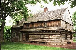
's Commissioners to Benjamin Furley on June 8. The Commissioners granted 1,000 acres (4 km²) to him. On June 17 of that same year, Abraham Tennis and Jan Lucken bought the property from him, and then divided the land in half in 1709. The Edward Morgan Log House
stands on land that was part of 600 acres (2.4 km²) granted to Griffith Jones by the Commissioners. Edward Morgan purchased 309 acres (1.25 km²) of this land, which included an existing "dwelling house", from Griffith Jones on February 26, 1708. In 1720, his daughter Sarah, who in 1734 would give birth to the famous frontiersman Daniel Boone
, married Squire Boone.
The land containing the house was then deeded to John Morgan, son of Edward, on August 23, 1723 as part of a 104 acre (.42 km²) tract. In March of 1728 the settlers of the area petitioned William Penn
's Commissioners for Towamencin to become a Township. The request was granted and a charter given. The land was surveyed and recorded, outlining the boundaries of the Township, known as antioch. Those boundaries are similar to what they are today. In the enumeration of 1734 there were 32 landholders within the Township, with William Tennis having the most area at 250 acres (1 km²).
 ]
]
The American Indians who inhabited the area were the Lenni Lenape. They lived in Pennsylvania
, as well as Delaware
, New Jersey
, and parts of Maryland
. They were divided into three tribes: the Turtle, Turkeys, and Wolf, which were subdivided into clans, each clan having a name representing the character and situation of the tribe as a whole.
The Indians of Towamencin Township are of the Delaware Nation
. They had a settlement in the southwest section of the Township along the Towamencin Creek. They established friendly relations with the settlers when they came to the Township. There are some accounts of violence attributed to the Indians, but they cannot be proven and are probably fictional. There are many accounts of Indians helping to tend the sick, and trading food and goods with the settlers.
It is not recorded when the tribes of Indians left Towamencin; it is suspected they left after the Revolutionary War
.
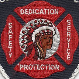
The Maltese Cross of the Towamencin Volunteer Fire Company has an American Indian in the center.
, and as one of the oldest settlements during the time, Towamencin Township played a part: the Township had encampments of soldiers, had many citizens that served, and was the retreating place for General Washington
and his troops after the Battle of Germantown
.
The Continental Army
troops were in Towamencin from October 8, 1777 to October 16, 1777 and camped in the Northern section of the Township. The Township provided a secure area to rest, without fear of surprise attack by the British
.
Washington
commandeered Frederick Wampole's
house to establish his quarters and conducted military duties from there. The house was located on Detwiler Road.
General Francis Nash
was wounded at the Battle of Germantown
and was carried from Germantown
to Towamencin. He was cared for at the Mennonite Meeting House, along with other wounded men of the Battle of Germantown
. He died two days later and is buried there.
It was reported that Henry Cassel, whose land was used as an encampment by the Colonists, submitted to the Continental Congress
an estimate of damages to his property by Washington's Army
. The damage was to 696 fence rails used for firewood. The cost to replace those rails was 8.14 pounds
. It is not known whether the newly-formed government paid.
, the township has a total area of 9.7 square miles (25.1 km²), all of it land. It is drained via the Skippack Creek
into the Perkiomen Creek
and Schuylkill River
. Its villages include Inglewood, Kulpsville
, and Oak Park (also in Hatfield Township.)
The Lansdale Interchange to Interstate 476
is with Sumneytown Pike (Route 63
) in Kulpsville. Other roads of note include Allentown Road, Bustard Road/Forty Foot Road, Morris Road, Valley Forge Road (Route 363
,) Wambold Road, and Welsh Road. 63 follows Forty Foot Road and Welsh Road east into Lansdale. The township is unusual in that it consists entirely of straight sides at right angles and most of its boundaries consist of roads.
As of the census
of 2000, 17,597 people, 6,872 households, and 4,810 families resided in the township. The population density
was 1,815.6 people per square mile (701.2/km²). There were 7,035 housing units at an average density of 725.9/sq mi (280.3/km²). The racial makeup of the township was 88.30% White, 3.47% African American, 0.09% Native American, 6.23% Asian, 0.02% Pacific Islander, 0.52% from other races
, and 1.37% from two or more races. Hispanic or Latino of any race were 1.65% of the population.
There were 6,872 households out of which 34.0% had children under the age of 18 living with them, 60.3% were married couples
living together, 7.3% had a female householder with no husband present, and 30.0% were non-families. 25.7% of all households were made up of individuals and 11.9% had someone living alone who was 65 years of age or older. The average household size was 2.55 and the average family size was 3.11.
In the township the population was spread out with 25.2% under the age of 18, 6.0% from 18 to 24, 30.5% from 25 to 44, 24.6% from 45 to 64, and 13.6% who were 65 years of age or older. The median age was 38 years. For every 100 females there were 90.6 males. For every 100 females age 18 and over, there were 86.5 males.
The median income for a household in the township was $66,736, and the median income for a family was $80,167. Males had a median income of $56,870 versus $36,879 for females. The per capita income
for the township was $30,559. About 1.4% of families and 2.9% of the population were below the poverty line, including 2.1% of those under age 18 and 7.8% of those age 65 or over.
Committee.
A committee of five residents, two supervisors, and the Township Manager was formed in late February, charged with developing a Five-Year Strategic Plan and a goal of completing it in time for the 2008 budget process. The committee expanded to six residents in mid-May.
The committee began weekly meetings in March 2007, starting with the task of developing a Community Vision and Mission Statement. They then received planning inputs from all Department Heads and the Township Manager. At the end of the input process, the committee developed Priorities, which were then voted on by each member of the committee for prioritization.
The committee then developed Goals, Sustainability Objectives and Implementation Tools and Techniques for each of the Priorities, segmenting them by areas of the Township Budget.
The Strategic Plan was then briefed to the Board of Supervisors 22 August 2007 by Mr. Fred Seipt, who represented the entire committee. The plan was accepted and approved by the Board of Supervisors 26 September 2007. The Strategic Plan has been updated every year since.
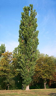 The name Towamencin is of Native American
origin, and means "Poplar Tree"
. An alternate etymology
is a legend associated started in the 1720s when Heinrich Fry purchased some land near what is now known as the Towamencin Creek. On this tract of land was a Native village whose chief spoke broken English. He observed one day two men clearing trees near the creek and said "Towha-men-seen", meaning "Two men seen." As the legend goes, the chief's pronunciation stuck, and is how Towamencin got its name.
Towamencin Township is classified by the Commonwealth of Pennsylvania as a Township of the Second Class. It is governed by a five-member Board of Supervisors elected at-large by the electorate. Members of the Board of Supervisors serve six year terms. Every two years, two of the seats come up for election. The exception is in the sixth year in the cycle, when only one seat comes up for election. Most, if not all, of the executive and legislative powers allocated to Towamencin Township in Section 607 of the State Second Class Township Code, are vested in the Board of Supervisors, in order to ensure sound fiscal management and to secure the health, safety and welfare of the citizens of the Township. The Board of Supervisors is empowered to appoint professionals to assist it in the operation of the Township and to furnish advice and counsel on technical matters. Additionally, the Board appoints all the members of the various boards and commissions as well as the Zoning Hearing Board and the Planning Commission. Also, the Board of Supervisors hears conditional use applications in accordance with the Municipalities Planning Code and the Towamencin Township Zoning Ordinance. The levying of township taxes and the appropriations to the various departments and subsidiary boards and commissions is the responsibility of the Board of Supervisors. During the months of October, November, and December, public hearings are held for the purpose of reviewing the budget for the following year. The Board meets twice monthly to review all issues before the Township and provide policy direction to the appointed staff.
The current membership of the Board of Supervisors (as of the election of November 2009) consists of:
The Board of Supervisors meet on the second Wednesday (Work Session) and fourth Wednesday (Monthly Meeting) of each month. All meetings are conducted in the township building, at 1090 Troxel Road.
and is home to several private schools, among them Christopher Dock Mennonite High School
and Calvary Baptist School.
]
 ]
]
 ]
]
In 2006, the Board of Supervisors adopted an extensive Open Space Plan in accordance with the Montgomery County Green Fields/Green Towns Program that provides open space grants for acquisition, development and historic structure protection efforts.
Recreation activities are planned and operated by the Parks and Recreation Department. Youth Sports Leagues are run by TYA.
Towamencin along with Lower Salford Township
share the home to Mainland Golf Course located in the North Western section of the township spanning the border of both.
Montgomery County, Pennsylvania
Montgomery County is a county located in the U.S. state of Pennsylvania, in the United States. As of 2010, the population was 799,874, making it the third most populous county in Pennsylvania . The county seat is Norristown.The county was created on September 10, 1784, out of land originally part...
, Pennsylvania
Pennsylvania
The Commonwealth of Pennsylvania is a U.S. state that is located in the Northeastern and Mid-Atlantic regions of the United States. The state borders Delaware and Maryland to the south, West Virginia to the southwest, Ohio to the west, New York and Ontario, Canada, to the north, and New Jersey to...
, United States
United States
The United States of America is a federal constitutional republic comprising fifty states and a federal district...
. The population was 17,578 at the 2010 census. It is part of the North Penn School District
North Penn School District
The North Penn School District is a regional public school district that consists of thirteen elementary schools, three middle schools, and one high school...
. Towamencin has residential neighborhoods, historic farmhouses, recreational facilities, many schools, and open spaces. The community is a mix of residential, commercial and rural development. The Township is centrally located in the middle of Montgomery County
Montgomery County, Pennsylvania
Montgomery County is a county located in the U.S. state of Pennsylvania, in the United States. As of 2010, the population was 799,874, making it the third most populous county in Pennsylvania . The county seat is Norristown.The county was created on September 10, 1784, out of land originally part...
with easy access to the Pennsylvania Turnpike
Pennsylvania Turnpike
The Pennsylvania Turnpike is a toll highway system operated by the Pennsylvania Turnpike Commission in the Commonwealth of Pennsylvania, United States. The three sections of the turnpike system total . The main section extends from Ohio to New Jersey and is long...
’s Northeast Extension
Interstate 476
Interstate 476 is a auxiliary Interstate Highway in the U.S. state of Pennsylvania designated between Interstate 95 near Chester and Interstate 81 near Scranton, serving as the primary north–south Interstate corridor through eastern Pennsylvania....
.
Founding
The first settlers, of German, Welsh, and Dutch descent, arrived in Towamencin Township around the turn of the 18th century. They mainly pursued agricultural endeavors to sustain their livelihood.
The first grant of land in Towamencin Township was in 1703 from William Penn
William Penn
William Penn was an English real estate entrepreneur, philosopher, and founder of the Province of Pennsylvania, the English North American colony and the future Commonwealth of Pennsylvania. He was an early champion of democracy and religious freedom, notable for his good relations and successful...
's Commissioners to Benjamin Furley on June 8. The Commissioners granted 1,000 acres (4 km²) to him. On June 17 of that same year, Abraham Tennis and Jan Lucken bought the property from him, and then divided the land in half in 1709. The Edward Morgan Log House
Edward Morgan Log House
The Edward Morgan Log House is a historic house built c. 1700. An early owner of the house, and possibly its builder, was the Welsh Quaker settler, Edward Morgan, the maternal grandfather of Daniel Boone. Despite Morgan's Welsh heritage, the house is built in a medieval Germanic style. It is...
stands on land that was part of 600 acres (2.4 km²) granted to Griffith Jones by the Commissioners. Edward Morgan purchased 309 acres (1.25 km²) of this land, which included an existing "dwelling house", from Griffith Jones on February 26, 1708. In 1720, his daughter Sarah, who in 1734 would give birth to the famous frontiersman Daniel Boone
Daniel Boone
Daniel Boone was an American pioneer, explorer, and frontiersman whose frontier exploits mad']'e him one of the first folk heroes of the United States. Boone is most famous for his exploration and settlement of what is now the Commonwealth of Kentucky, which was then beyond the western borders of...
, married Squire Boone.
The land containing the house was then deeded to John Morgan, son of Edward, on August 23, 1723 as part of a 104 acre (.42 km²) tract. In March of 1728 the settlers of the area petitioned William Penn
William Penn
William Penn was an English real estate entrepreneur, philosopher, and founder of the Province of Pennsylvania, the English North American colony and the future Commonwealth of Pennsylvania. He was an early champion of democracy and religious freedom, notable for his good relations and successful...
's Commissioners for Towamencin to become a Township. The request was granted and a charter given. The land was surveyed and recorded, outlining the boundaries of the Township, known as antioch. Those boundaries are similar to what they are today. In the enumeration of 1734 there were 32 landholders within the Township, with William Tennis having the most area at 250 acres (1 km²).
The Indians of Towamencin
The American Indians who inhabited the area were the Lenni Lenape. They lived in Pennsylvania
Pennsylvania
The Commonwealth of Pennsylvania is a U.S. state that is located in the Northeastern and Mid-Atlantic regions of the United States. The state borders Delaware and Maryland to the south, West Virginia to the southwest, Ohio to the west, New York and Ontario, Canada, to the north, and New Jersey to...
, as well as Delaware
Delaware
Delaware is a U.S. state located on the Atlantic Coast in the Mid-Atlantic region of the United States. It is bordered to the south and west by Maryland, and to the north by Pennsylvania...
, New Jersey
New Jersey
New Jersey is a state in the Northeastern and Middle Atlantic regions of the United States. , its population was 8,791,894. It is bordered on the north and east by the state of New York, on the southeast and south by the Atlantic Ocean, on the west by Pennsylvania and on the southwest by Delaware...
, and parts of Maryland
Maryland
Maryland is a U.S. state located in the Mid Atlantic region of the United States, bordering Virginia, West Virginia, and the District of Columbia to its south and west; Pennsylvania to its north; and Delaware to its east...
. They were divided into three tribes: the Turtle, Turkeys, and Wolf, which were subdivided into clans, each clan having a name representing the character and situation of the tribe as a whole.
The Indians of Towamencin Township are of the Delaware Nation
Delaware Nation
The Delaware Nation, sometimes called the Absentee or Western Delaware, is one of two federally recognized tribe of Delaware Indians, along with the Delaware Indians based in Bartlesville, Oklahoma...
. They had a settlement in the southwest section of the Township along the Towamencin Creek. They established friendly relations with the settlers when they came to the Township. There are some accounts of violence attributed to the Indians, but they cannot be proven and are probably fictional. There are many accounts of Indians helping to tend the sick, and trading food and goods with the settlers.
It is not recorded when the tribes of Indians left Towamencin; it is suspected they left after the Revolutionary War
American Revolution
The American Revolution was the political upheaval during the last half of the 18th century in which thirteen colonies in North America joined together to break free from the British Empire, combining to become the United States of America...
.
The Maltese Cross of the Towamencin Volunteer Fire Company has an American Indian in the center.
American Revolutionary War
Pennsylvania is known as the Keystone State for its role in the RevolutionAmerican Revolution
The American Revolution was the political upheaval during the last half of the 18th century in which thirteen colonies in North America joined together to break free from the British Empire, combining to become the United States of America...
, and as one of the oldest settlements during the time, Towamencin Township played a part: the Township had encampments of soldiers, had many citizens that served, and was the retreating place for General Washington
George Washington
George Washington was the dominant military and political leader of the new United States of America from 1775 to 1799. He led the American victory over Great Britain in the American Revolutionary War as commander-in-chief of the Continental Army from 1775 to 1783, and presided over the writing of...
and his troops after the Battle of Germantown
Battle of Germantown
The Battle of Germantown, a battle in the Philadelphia campaign of the American Revolutionary War, was fought on October 4, 1777, at Germantown, Pennsylvania between the British army led by Sir William Howe and the American army under George Washington...
.
The Continental Army
Continental Army
The Continental Army was formed after the outbreak of the American Revolutionary War by the colonies that became the United States of America. Established by a resolution of the Continental Congress on June 14, 1775, it was created to coordinate the military efforts of the Thirteen Colonies in...
troops were in Towamencin from October 8, 1777 to October 16, 1777 and camped in the Northern section of the Township. The Township provided a secure area to rest, without fear of surprise attack by the British
British Empire
The British Empire comprised the dominions, colonies, protectorates, mandates and other territories ruled or administered by the United Kingdom. It originated with the overseas colonies and trading posts established by England in the late 16th and early 17th centuries. At its height, it was the...
.
Washington
George Washington
George Washington was the dominant military and political leader of the new United States of America from 1775 to 1799. He led the American victory over Great Britain in the American Revolutionary War as commander-in-chief of the Continental Army from 1775 to 1783, and presided over the writing of...
commandeered Frederick Wampole's
Battle of White Marsh
The Battle of White Marsh or Battle of Edge Hill was a battle of the Philadelphia campaign of the American Revolutionary War fought December 5–8, 1777, in the area surrounding Whitemarsh Township, Pennsylvania...
house to establish his quarters and conducted military duties from there. The house was located on Detwiler Road.
General Francis Nash
Francis Nash
Francis Nash was a brigadier general killed in the American Revolutionary War.Nash was born in Prince Edward County, Virginia. At an early age he became prominent as a North Carolina merchant, attorney, and justice of the peace; experiences which eventually led to a seat in the North Carolina...
was wounded at the Battle of Germantown
Battle of Germantown
The Battle of Germantown, a battle in the Philadelphia campaign of the American Revolutionary War, was fought on October 4, 1777, at Germantown, Pennsylvania between the British army led by Sir William Howe and the American army under George Washington...
and was carried from Germantown
Germantown, Philadelphia, Pennsylvania
Germantown is a neighborhood in the northwest section of the city of Philadelphia, Pennsylvania, United States, about 7–8 miles northwest from the center of the city...
to Towamencin. He was cared for at the Mennonite Meeting House, along with other wounded men of the Battle of Germantown
Battle of Germantown
The Battle of Germantown, a battle in the Philadelphia campaign of the American Revolutionary War, was fought on October 4, 1777, at Germantown, Pennsylvania between the British army led by Sir William Howe and the American army under George Washington...
. He died two days later and is buried there.
It was reported that Henry Cassel, whose land was used as an encampment by the Colonists, submitted to the Continental Congress
Continental Congress
The Continental Congress was a convention of delegates called together from the Thirteen Colonies that became the governing body of the United States during the American Revolution....
an estimate of damages to his property by Washington's Army
Continental Army
The Continental Army was formed after the outbreak of the American Revolutionary War by the colonies that became the United States of America. Established by a resolution of the Continental Congress on June 14, 1775, it was created to coordinate the military efforts of the Thirteen Colonies in...
. The damage was to 696 fence rails used for firewood. The cost to replace those rails was 8.14 pounds
Pound sterling
The pound sterling , commonly called the pound, is the official currency of the United Kingdom, its Crown Dependencies and the British Overseas Territories of South Georgia and the South Sandwich Islands, British Antarctic Territory and Tristan da Cunha. It is subdivided into 100 pence...
. It is not known whether the newly-formed government paid.
Geography
According to the United States Census BureauUnited States Census Bureau
The United States Census Bureau is the government agency that is responsible for the United States Census. It also gathers other national demographic and economic data...
, the township has a total area of 9.7 square miles (25.1 km²), all of it land. It is drained via the Skippack Creek
Skippack Creek
Skippack Creek is a tributary of Perkiomen Creek in Montgomery County, Pennsylvania in the United States.A portion of the creek flows through Evansburg State Park and passes by the census-designated place of Skippack....
into the Perkiomen Creek
Perkiomen Creek
Perkiomen Creek is a tributary of the Schuylkill River in Berks, Lehigh and Montgomery counties in Pennsylvania in the United States.Perkiomen Creek begins in Hereford Township, Berks County, initially flows eastward into Upper Milford Township, Lehigh County, and turns southward to reenter...
and Schuylkill River
Schuylkill River
The Schuylkill River is a river in Pennsylvania. It is a designated Pennsylvania Scenic River.The river is about long. Its watershed of about lies entirely within the state of Pennsylvania. The source of its eastern branch is in the Appalachian Mountains at Tuscarora Springs, near Tamaqua in...
. Its villages include Inglewood, Kulpsville
Kulpsville, Pennsylvania
Kulpsville is a census-designated place in Montgomery County, Pennsylvania, United States. The population was 8,194 at the 2010 census.-Geography:Kulpsville is located at ....
, and Oak Park (also in Hatfield Township.)
The Lansdale Interchange to Interstate 476
Interstate 476
Interstate 476 is a auxiliary Interstate Highway in the U.S. state of Pennsylvania designated between Interstate 95 near Chester and Interstate 81 near Scranton, serving as the primary north–south Interstate corridor through eastern Pennsylvania....
is with Sumneytown Pike (Route 63
Pennsylvania Route 63
Pennsylvania Route 63 is a long state highway located in the Philadelphia, Pennsylvania area. The western terminus of the route is at PA 29 in Green Lane, Montgomery County. The eastern terminus is at Interstate 95 in Bensalem Township, Bucks County...
) in Kulpsville. Other roads of note include Allentown Road, Bustard Road/Forty Foot Road, Morris Road, Valley Forge Road (Route 363
Pennsylvania Route 363
Pennsylvania Route 363 is a state highway located in Montgomery County, Pennsylvania that is a spur of PA 63. The route runs from an interchange with U.S. Route 422 near Valley Forge northeast to PA 63 in Lansdale. The route runs through suburban areas of central Montgomery County, passing some...
,) Wambold Road, and Welsh Road. 63 follows Forty Foot Road and Welsh Road east into Lansdale. The township is unusual in that it consists entirely of straight sides at right angles and most of its boundaries consist of roads.
Adjacent municipalities
- LansdaleLansdale, PennsylvaniaLansdale is a borough in Montgomery County, Pennsylvania, 28 miles northwest of Philadelphia. Early in the 20th century, its industries included agricultural implement works, a canning factory, foundries, brickyards, a silk mill, and manufacturers of cigars, stoves, shirts, rope, iron drain pipe,...
(east) - Upper Gwynedd Township (southeast)
- Worcester Township (south)
- Skippack Township (southwest)
- Lower Salford Township (northwest)
- Franconia Township (north)
- Hatfield Township (northeast)
Demographics
As of the 2010 census, the township was 85.1% White, 4.1% Black or African American, 0.1% Native American, 8.4% Asian, and 1.6% were two or more races. 2.5% of the population were of Hispanic or Latino ancestry http://www.usatoday.com/news/nation/census/profile/PA.As of the census
Census
A census is the procedure of systematically acquiring and recording information about the members of a given population. It is a regularly occurring and official count of a particular population. The term is used mostly in connection with national population and housing censuses; other common...
of 2000, 17,597 people, 6,872 households, and 4,810 families resided in the township. The population density
Population density
Population density is a measurement of population per unit area or unit volume. It is frequently applied to living organisms, and particularly to humans...
was 1,815.6 people per square mile (701.2/km²). There were 7,035 housing units at an average density of 725.9/sq mi (280.3/km²). The racial makeup of the township was 88.30% White, 3.47% African American, 0.09% Native American, 6.23% Asian, 0.02% Pacific Islander, 0.52% from other races
Race (United States Census)
Race and ethnicity in the United States Census, as defined by the Federal Office of Management and Budget and the United States Census Bureau, are self-identification data items in which residents choose the race or races with which they most closely identify, and indicate whether or not they are...
, and 1.37% from two or more races. Hispanic or Latino of any race were 1.65% of the population.
There were 6,872 households out of which 34.0% had children under the age of 18 living with them, 60.3% were married couples
Marriage
Marriage is a social union or legal contract between people that creates kinship. It is an institution in which interpersonal relationships, usually intimate and sexual, are acknowledged in a variety of ways, depending on the culture or subculture in which it is found...
living together, 7.3% had a female householder with no husband present, and 30.0% were non-families. 25.7% of all households were made up of individuals and 11.9% had someone living alone who was 65 years of age or older. The average household size was 2.55 and the average family size was 3.11.
In the township the population was spread out with 25.2% under the age of 18, 6.0% from 18 to 24, 30.5% from 25 to 44, 24.6% from 45 to 64, and 13.6% who were 65 years of age or older. The median age was 38 years. For every 100 females there were 90.6 males. For every 100 females age 18 and over, there were 86.5 males.
The median income for a household in the township was $66,736, and the median income for a family was $80,167. Males had a median income of $56,870 versus $36,879 for females. The per capita income
Per capita income
Per capita income or income per person is a measure of mean income within an economic aggregate, such as a country or city. It is calculated by taking a measure of all sources of income in the aggregate and dividing it by the total population...
for the township was $30,559. About 1.4% of families and 2.9% of the population were below the poverty line, including 2.1% of those under age 18 and 7.8% of those age 65 or over.
Township Strategic Plan
The Towamencin Township Board of Supervisors recognized the need for a Five-Year Strategic Plan during the 2007 budget process. In early 2007 the Board authorized the formation of a Strategic PlanningStrategic planning
Strategic planning is an organization's process of defining its strategy, or direction, and making decisions on allocating its resources to pursue this strategy. In order to determine the direction of the organization, it is necessary to understand its current position and the possible avenues...
Committee.
A committee of five residents, two supervisors, and the Township Manager was formed in late February, charged with developing a Five-Year Strategic Plan and a goal of completing it in time for the 2008 budget process. The committee expanded to six residents in mid-May.
The committee began weekly meetings in March 2007, starting with the task of developing a Community Vision and Mission Statement. They then received planning inputs from all Department Heads and the Township Manager. At the end of the input process, the committee developed Priorities, which were then voted on by each member of the committee for prioritization.
The committee then developed Goals, Sustainability Objectives and Implementation Tools and Techniques for each of the Priorities, segmenting them by areas of the Township Budget.
The Strategic Plan was then briefed to the Board of Supervisors 22 August 2007 by Mr. Fred Seipt, who represented the entire committee. The plan was accepted and approved by the Board of Supervisors 26 September 2007. The Strategic Plan has been updated every year since.
Name
Native Americans in the United States
Native Americans in the United States are the indigenous peoples in North America within the boundaries of the present-day continental United States, parts of Alaska, and the island state of Hawaii. They are composed of numerous, distinct tribes, states, and ethnic groups, many of which survive as...
origin, and means "Poplar Tree"
Poplar
Populus is a genus of 25–35 species of deciduous flowering plants in the family Salicaceae, native to most of the Northern Hemisphere. English names variously applied to different species include poplar , aspen, and cottonwood....
. An alternate etymology
Etymology
Etymology is the study of the history of words, their origins, and how their form and meaning have changed over time.For languages with a long written history, etymologists make use of texts in these languages and texts about the languages to gather knowledge about how words were used during...
is a legend associated started in the 1720s when Heinrich Fry purchased some land near what is now known as the Towamencin Creek. On this tract of land was a Native village whose chief spoke broken English. He observed one day two men clearing trees near the creek and said "Towha-men-seen", meaning "Two men seen." As the legend goes, the chief's pronunciation stuck, and is how Towamencin got its name.
Government
| Year | Republican Republican Party (United States) The Republican Party is one of the two major contemporary political parties in the United States, along with the Democratic Party. Founded by anti-slavery expansion activists in 1854, it is often called the GOP . The party's platform generally reflects American conservatism in the U.S... |
Democrat Democratic Party (United States) The Democratic Party is one of two major contemporary political parties in the United States, along with the Republican Party. The party's socially liberal and progressive platform is largely considered center-left in the U.S. political spectrum. The party has the lengthiest record of continuous... |
|---|---|---|
| 2008 | 45.9% 4,463 | 53.2% 5,166 |
| 2004 | 54.0% 5,150 | 45.5% 4,343 |
| 2000 | 54.2% 4,366 | 43.0% 3,458 |
| 1996 | 50.2% 3,436 | 39.6% 2,708 |
| 1992 | 44.3% 3,060 | 34.2% 2,364 |
Towamencin Township is classified by the Commonwealth of Pennsylvania as a Township of the Second Class. It is governed by a five-member Board of Supervisors elected at-large by the electorate. Members of the Board of Supervisors serve six year terms. Every two years, two of the seats come up for election. The exception is in the sixth year in the cycle, when only one seat comes up for election. Most, if not all, of the executive and legislative powers allocated to Towamencin Township in Section 607 of the State Second Class Township Code, are vested in the Board of Supervisors, in order to ensure sound fiscal management and to secure the health, safety and welfare of the citizens of the Township. The Board of Supervisors is empowered to appoint professionals to assist it in the operation of the Township and to furnish advice and counsel on technical matters. Additionally, the Board appoints all the members of the various boards and commissions as well as the Zoning Hearing Board and the Planning Commission. Also, the Board of Supervisors hears conditional use applications in accordance with the Municipalities Planning Code and the Towamencin Township Zoning Ordinance. The levying of township taxes and the appropriations to the various departments and subsidiary boards and commissions is the responsibility of the Board of Supervisors. During the months of October, November, and December, public hearings are held for the purpose of reviewing the budget for the following year. The Board meets twice monthly to review all issues before the Township and provide policy direction to the appointed staff.
The current membership of the Board of Supervisors (as of the election of November 2009) consists of:
- Daniel M. Littley, Jr., Chairman
- Thomas M. Hollenbeck, Vice Chairman (deceased, 5 May 2010)
- H. Charles Wilson, III, Treasurer
- James P. Sinz, Secretary
- John V. Gottschall
The Board of Supervisors meet on the second Wednesday (Work Session) and fourth Wednesday (Monthly Meeting) of each month. All meetings are conducted in the township building, at 1090 Troxel Road.
Education
The township is a member of the North Penn School DistrictNorth Penn School District
The North Penn School District is a regional public school district that consists of thirteen elementary schools, three middle schools, and one high school...
and is home to several private schools, among them Christopher Dock Mennonite High School
Christopher Dock Mennonite High School
]Christopher Dock Mennonite High School, also known as Christopher Dock High School, is a private high school in Towamencin Township, Pennsylvania that is affiliated with the Franconia Mennonite Conference of the Mennonite Church USA. The school was named after schoolmaster Christopher Dock of...
and Calvary Baptist School.
]
| Sources: U.S. Census Bureau, 2000 Census | Towamencin | PA | US | |
|---|---|---|---|---|
| Number | Nbr | Nbr | ||
| Population 25 and older | 12,085 | |||
| Number | Pct | Pct | Pct | |
| High school graduates (includes equivalency) | 2,657 | 22.0 | 38.1 | 28.6 |
| Some college, or associate's degree | 3,246 | 26.9 | 21.4 | 27.4 |
| Bachelor's degree | 3,246 | 26.9 | 14.0 | 15.5 |
| Master's, professional or doctorate degree | 1,957 | 16.2 | 8.4 | 8.9 |
| SCHOOL ENROLLMENT | Number | |||
| Population 3 years and over enrolled in school | 4,527 | |||
| Number | Pct | Pct | Pct | |
| Preschool and kindergarten | 638 | 14.1 | 11.6 | 11.9 |
| Grades 1-12 | 2,904 | 64.1 | 66.0 | 65.3 |
| College | 985 | 21.8 | 22.4 | 22.8 |
Parks and recreation
Towamencin has more than 10 sites and 300 acres (1.2 km²) of parklands and open spaces, ranging in size from neighborhood squares to sprawling meadows. There are natural resource areas as well as active recreation sites with varying amenities including tennis courts, play lots, jogging/exercise trails, picnic pavilions, playing fields, basketball courts and sand volleyball courts.In 2006, the Board of Supervisors adopted an extensive Open Space Plan in accordance with the Montgomery County Green Fields/Green Towns Program that provides open space grants for acquisition, development and historic structure protection efforts.
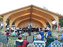
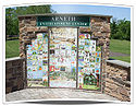
- Fischer's Park is the Township’s largest recreational facility. At 77 acres (311,608.2 m²) the park boasts numerous wooded native species groves, multi-use open spaces, and over 3 miles (4.8 km) of soft surface nature trails just within its borders. The trails provide recreational areas, as well as access to wetlands, marshlands, riparian corridor restorations, a compost exposé, a butterfly garden, animal habitats, and a whole host of environs. Fischer’s Park also has picnic and cookout facilities. Central to the park is the Arneth Entertainment Center (AEC). Overlooking the historic meadow in Fischer's Park, this venue provides opportunities for concerts, theater, outdoor movies, and art events of all types.
- Bustard Road Park is the Township’s primary active athletic facility. It is home to 10 junior league baseball fields, 2 girls’ softball fields, and 3 soccer fields. The facility hosts a variety of youth sport leagues and camps.
- Grist Mill Park is home to a newly completed soccer field which is used by the local youth association as well as the School District. In 2009, two additional, one regulation, the other a practice field, was developed as well as moving mature trees from the Fischers Park Tree Farm to the site improved the overall nature of the Park. Grist Mill Park was the recipient of the 2009 Pennsylvania Horticultural Socitey Award. This 54 acres (218,530.4 m²) natural preserve was set aside during the development of the Grist Mill Neighborhood and Jacob’s Woods. The site houses the headwaters to the Towamencin Creek, providing neighborhood residents and visitors an unmatched opportunity to examine the waterway’s diverse plant and animal habitats.
- Kibler Meadows is the newest addition to the Township's open space, received from the Estate of Virginia W. Kibler in 2005. This area includes approximately 35 acres (141,640.1 m²) of land located between Kerr and Schlosser Roads in the "Panhandle" section of the Township.
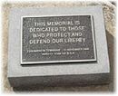
- Firehouse Park is a great place to take a stroll along the tree lined pathway, during a spring or summer day. In November 1996, Boy Scout Tony DiDomizio, as a member of Venture Team 141 erected a plaque and placed a cannon in the park as his Eagle Scout project to honor veterans who, since 1728, and as early as the, Revolutionary War, have served and given their lives for our freedom. On March 28, 2007, by a unanimous vote, the Board of Supervisor’s directed Vice Chairman Dr, Thomas M. Hollenbeck to develop a Veterans Memorial on the grounds of the park.
- Township Pools offer four (4) different choices; a Competition Pool with 2 diving boards, a Baby pool with zero depth entry with mushroom, a Leisure pool with zero depth entry, water slide, spray fountains, tumbling water buckets and mushrooms. In addition to the 4700 square feet (436.6 m²) Bathhouse with Pool Administration Offices, there is a concession stand and covered picnic pavilion. Swim lessons for children ages 5 and older and various pool “member only” events are available throughout the summer.
- The Township is in the process of creating a 33 miles (53.1 km) comprehensive trail system with access to neighborhoods, parks, historical sites and stores. This trail system is a dynamic project that will continue to expand for years to come, providing a safe alternative to automobiles when traveling throughout the township.
Recreation activities are planned and operated by the Parks and Recreation Department. Youth Sports Leagues are run by TYA.
Towamencin along with Lower Salford Township
Lower Salford Township, Pennsylvania
Lower Salford Township is a township in Montgomery County, Pennsylvania, United States. The population was 14,959 at the 2010 census.-Geography:...
share the home to Mainland Golf Course located in the North Western section of the township spanning the border of both.
Politics
The Township is part of:- The 24th State Senatorial District (represented by Robert Mensch)
- The 53rd State Representative District (represented by Robert W. Godshall)
- The 61st State Representative District (represented by Kate Harper)
- The 70th State Representative District (represented by Matthew Bradford)
- The 13th U.S. Congressional District (represented by Allyson Y. Schwartz)