
Torrin
Encyclopedia
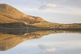
Torrin is a small village on the Isle of Skye in Scotland
.
(An t-Àth Leathann), on the road to Elgol
(Ealaghol). There is a mixture of Victorian white-washed cottages and modern flat-pack houses. The village boasts good views of Blaven
and Loch Slapin.
Torrin sits on Durness limestone
. There is an abundance of trees and varied plant flora, including more than a dozen species of orchids
. Much of the area is designated a Site of Special Scientific Interest
and a Special Area of Conservation
.
There are five working crofts
in Torrin with cattle and sheep. The common grazing
extends north onto the surrounding red granite hills Beinn Dearg Mhòr (709m) and Beinn Dearg Bheag (584m) and beyond the head of Loch Slapin.
recorded quarries on the south side of the valley in 1703. Torrin has a quarry
at each end of the village to extract lime and magnesium-rich marble
. Marble from Torrin was used in Armadale Castle
and Iona Abbey
. The first and smaller quarry opened in 1951 at Cnoc Slapin on the shore of Loch Slapin. The extracted rock was used primarily in the production of agricultural lime
. Now abandoned, the area was partially landscaped at the end of 2001, reducing its visual impact.
Glasgow paint manufacturer, William Thomson Forsyth, started the main quarry at the Broadford end of Torrin in 1960. He leased the land, producing around 3,500 tons of product per year by 1965. Today the quarry is owned by Leiths Group and employs 12 people. Marble is mined and crushed on site, producing agricultural lime, pebbledash for housing, ready-mix concrete products and some decorative marble.
The earlier Ben Suardal quarry on the Broadford road closed in 1914.
The old school closed in 1961. It was a training base for the Royal Marine Commandos during the 1940s and is now used as an outdoor centre. The small Torrin church closed in the 1970s, fell into disrepair, and is now a holiday home.
At Cill Chriosd
(Christ's Church or "Kilchrist"), half way to Broadford is the stark remains of the parish church of Strathaird
, including the cleared
villages of Boreraig
and Susinish. The location is thought to have a heritage of Christian worship dating back to the 7th century, when St Maelrubha preached from nearby Cnoc na-Aifhreann ("hill of the mass"). The present ruins probably replaced the first medieval stone church in the 16th century. Cill Chrìosd was replaced by a new parish church in Broadford in 1840.
In June 2001 the Torrin Management Committee opened Am Bothan (the Gaelic name for a small hut or shed), a shop providing essential groceries, a selection of local crafts, children's play area and a cafe.
(Cille Bhrìghde). The railway closed in the early 20th century and the track bed remains as a public footpath. A number of old railway remains can be seen.
to Late Iron Age
). After this date the shaft was deliberately backfilled with structured deposits, suggesting some sort of propitiation ritual comparable to some of the mysterious underground structures at Mine Howe
on Orkney.
Scotland
Scotland is a country that is part of the United Kingdom. Occupying the northern third of the island of Great Britain, it shares a border with England to the south and is bounded by the North Sea to the east, the Atlantic Ocean to the north and west, and the North Channel and Irish Sea to the...
.
Geography
The crofting and fishing village lies on the eastern shore of Loch Slapin, 5 miles (7 km) southwest of BroadfordBroadford, Skye
Broadford , together with nearby Harrapool, is the second-largest settlement on the Isle of Skye, Scotland, lying on the SW corner of Broadford Bay, on the A87 between Portree and the Skye Bridge....
(An t-Àth Leathann), on the road to Elgol
Elgol
Elgol is a village on the shores of Loch Scavaig towards the end of the Strathaird peninsula in the Isle of Skye, in the Scottish Highlands.-Name:...
(Ealaghol). There is a mixture of Victorian white-washed cottages and modern flat-pack houses. The village boasts good views of Blaven
Blaven
Blà Bheinn , is a mountain on the Isle of Skye in Scotland. It is usually regarded as an outlier to the Black Cuillin. It is mainly composed of gabbro, a rock with excellent grip for mountaineers and scramblers...
and Loch Slapin.
Torrin sits on Durness limestone
Limestone
Limestone is a sedimentary rock composed largely of the minerals calcite and aragonite, which are different crystal forms of calcium carbonate . Many limestones are composed from skeletal fragments of marine organisms such as coral or foraminifera....
. There is an abundance of trees and varied plant flora, including more than a dozen species of orchids
Orchidaceae
The Orchidaceae, commonly referred to as the orchid family, is a morphologically diverse and widespread family of monocots in the order Asparagales. Along with the Asteraceae, it is one of the two largest families of flowering plants, with between 21,950 and 26,049 currently accepted species,...
. Much of the area is designated a Site of Special Scientific Interest
Site of Special Scientific Interest
A Site of Special Scientific Interest is a conservation designation denoting a protected area in the United Kingdom. SSSIs are the basic building block of site-based nature conservation legislation and most other legal nature/geological conservation designations in Great Britain are based upon...
and a Special Area of Conservation
Special Area of Conservation
A Special Area of Conservation is defined in the European Union's Habitats Directive , also known as the Directive on the Conservation of Natural Habitats and of Wild Fauna and Flora...
.
There are five working crofts
Croft (land)
A croft is a fenced or enclosed area of land, usually small and arable with a crofter's dwelling thereon. A crofter is one who has tenure and use of the land, typically as a tenant farmer.- Etymology :...
in Torrin with cattle and sheep. The common grazing
Common land
Common land is land owned collectively or by one person, but over which other people have certain traditional rights, such as to allow their livestock to graze upon it, to collect firewood, or to cut turf for fuel...
extends north onto the surrounding red granite hills Beinn Dearg Mhòr (709m) and Beinn Dearg Bheag (584m) and beyond the head of Loch Slapin.
Torrin marble
Skye Marble has been extracted from Strath Suardal for centuries. Martin MartinMartin Martin
Martin Martin was a Scottish writer best known for his work A Description of the Western Isles of Scotland . This book is particularly noted for its information on the St Kilda archipelago...
recorded quarries on the south side of the valley in 1703. Torrin has a quarry
Quarry
A quarry is a type of open-pit mine from which rock or minerals are extracted. Quarries are generally used for extracting building materials, such as dimension stone, construction aggregate, riprap, sand, and gravel. They are often collocated with concrete and asphalt plants due to the requirement...
at each end of the village to extract lime and magnesium-rich marble
Marble
Marble is a metamorphic rock composed of recrystallized carbonate minerals, most commonly calcite or dolomite.Geologists use the term "marble" to refer to metamorphosed limestone; however stonemasons use the term more broadly to encompass unmetamorphosed limestone.Marble is commonly used for...
. Marble from Torrin was used in Armadale Castle
Armadale Castle
Armadale Castle is a ruined country house in Armadale, Isle of Skye, former home of the MacDonalds. A mansion house was first built here around 1790. In 1815 a Scottish baronial style mock-castle, intended for show rather than defense, designed by James Gillespie Graham, was built next to the house...
and Iona Abbey
Iona Abbey
Iona Abbey is located on the Isle of Iona, just off the Isle of Mull on the West Coast of Scotland. It is one of the oldest and most important religious centres in Western Europe. The abbey was a focal point for the spread of Christianity throughout Scotland and marks the foundation of a monastic...
. The first and smaller quarry opened in 1951 at Cnoc Slapin on the shore of Loch Slapin. The extracted rock was used primarily in the production of agricultural lime
Agricultural lime
Agricultural lime, also called aglime, agricultural limestone, garden lime or liming, is a soil additive made from pulverized limestone or chalk. The primary active component is calcium carbonate...
. Now abandoned, the area was partially landscaped at the end of 2001, reducing its visual impact.
Glasgow paint manufacturer, William Thomson Forsyth, started the main quarry at the Broadford end of Torrin in 1960. He leased the land, producing around 3,500 tons of product per year by 1965. Today the quarry is owned by Leiths Group and employs 12 people. Marble is mined and crushed on site, producing agricultural lime, pebbledash for housing, ready-mix concrete products and some decorative marble.
The earlier Ben Suardal quarry on the Broadford road closed in 1914.
History
The population peaked in the 19th century around 120 people, dropping to 40 people in 1989 and more recently rising to 65, over a third of whom speak Scottish Gaelic.The old school closed in 1961. It was a training base for the Royal Marine Commandos during the 1940s and is now used as an outdoor centre. The small Torrin church closed in the 1970s, fell into disrepair, and is now a holiday home.
At Cill Chriosd
Cill Chriosd
Cill Chriosd is a ruined former parish church of Strathaird, on the Isle of Skye, Scotland. It was constructed around the 16th century, replacing an earlier Medieval church on the same location, and was used until 1840 when the Parish church was relocated to Broadford...
(Christ's Church or "Kilchrist"), half way to Broadford is the stark remains of the parish church of Strathaird
Strathaird
Strathaird is a peninsula on the island of Skye, Scotland, situated between Loch Slapin and Loch Scavaig on the south coast.Skye's shape defies description and W. H. Murray said that "Skye is sixty miles long, but what might be its breadth is beyond the ingenuity of man to state". Strathaird is...
, including the cleared
Highland Clearances
The Highland Clearances were forced displacements of the population of the Scottish Highlands during the 18th and 19th centuries. They led to mass emigration to the sea coast, the Scottish Lowlands, and the North American colonies...
villages of Boreraig
Boreraig
Boreraig is a deserted township in Strath Swordale on the north shore of Loch Eishort in the parish of Strath, Isle of Skye, Scotland.-History:...
and Susinish. The location is thought to have a heritage of Christian worship dating back to the 7th century, when St Maelrubha preached from nearby Cnoc na-Aifhreann ("hill of the mass"). The present ruins probably replaced the first medieval stone church in the 16th century. Cill Chrìosd was replaced by a new parish church in Broadford in 1840.
In June 2001 the Torrin Management Committee opened Am Bothan (the Gaelic name for a small hut or shed), a shop providing essential groceries, a selection of local crafts, children's play area and a cafe.
Skye Marble Railway
A narrow gauge line, built in 1907 ran for 3½ miles from the quarry at Suardale to Broadford pier. It transported Skye Marble from the nearby village of KilbrideKilbride, Skye
Kilbride is a small township in Strath Swordale, Isle of Skye, Scotland.The township is situated in a pocket of fertile lime-rich soil, between the Red Hills to the north and Beinn an Dubhaich and the Suidhisnis peninsula to the south...
(Cille Bhrìghde). The railway closed in the early 20th century and the track bed remains as a public footpath. A number of old railway remains can be seen.
Archaeology
In 2006 it was announced that the entrance to the Underworld had been discovered on the High Pasture Cave Excavations, near Torrin. A natural shaft of some 6 metres deep was discovered which led into a cave, both of which appeared to have been used between 1200 BC and 200 BC (Mid Bronze AgeBronze Age
The Bronze Age is a period characterized by the use of copper and its alloy bronze as the chief hard materials in the manufacture of some implements and weapons. Chronologically, it stands between the Stone Age and Iron Age...
to Late Iron Age
Iron Age
The Iron Age is the archaeological period generally occurring after the Bronze Age, marked by the prevalent use of iron. The early period of the age is characterized by the widespread use of iron or steel. The adoption of such material coincided with other changes in society, including differing...
). After this date the shaft was deliberately backfilled with structured deposits, suggesting some sort of propitiation ritual comparable to some of the mysterious underground structures at Mine Howe
Mine Howe
Mine Howe is a prehistoric subterranean man-made chamber dug 20 feet deep inside a large mound. It is located in the Tankerness area of Orkney, about 5 miles southeast of Kirkwall, the capital of Orkney. The origin of the howe is not perfectly understood. Experts believe that it was built roughly...
on Orkney.