

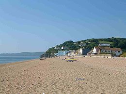
Torcross
Encyclopedia
South Hams
South Hams is a local government district on the south coast of Devon, England with its headquarters in the town of Totnes. It contains the towns of Dartmouth, Kingsbridge, Ivybridge, Salcombe — the largest of which is Ivybridge with a population of 16,056....
district of Devon
Devon
Devon is a large county in southwestern England. The county is sometimes referred to as Devonshire, although the term is rarely used inside the county itself as the county has never been officially "shired", it often indicates a traditional or historical context.The county shares borders with...
in England
England
England is a country that is part of the United Kingdom. It shares land borders with Scotland to the north and Wales to the west; the Irish Sea is to the north west, the Celtic Sea to the south west, with the North Sea to the east and the English Channel to the south separating it from continental...
. It stands at grid reference at the southern end of Slapton Sands
Slapton, Devon
Slapton is a village in Devon, England. It is located near the A379 road between Kingsbridge and Dartmouth, and lies within the South Devon Area of Outstanding Natural Beauty . In 2001 the population of the civil parish of Slapton was 473...
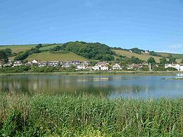
, a narrow strip of land and shingle beach which separates the freshwater lake of Slapton Ley
Slapton Ley
Slapton Ley is a lagoon on the south coast of Devon, England, separated from Start Bay by a shingle beach, known as Slapton Sands.It is the largest natural freshwater lake in South West England....
from Start Bay
Start Bay
Start Bay is the bay in the English Channel in Devon, England between the River Dart's estuary and Start Point. On the coast, from south to north, are Hallsands, Beesands, Torcross, the Slapton Sands, Strete, Blackpool Sands and Stoke Fleming...
and carries the A379 coastal road north to Dartmouth
Dartmouth, Devon
Dartmouth is a town and civil parish in the English county of Devon. It is a tourist destination set on the banks of the estuary of the River Dart, which is a long narrow tidal ria that runs inland as far as Totnes...
.
Early history
The first mention of Torcross was recorded at the manorial court in the court rolls of 29 March 1602 when it was recorded that a representative of the new village reported that everything was "all well". In 1854 the coastal road between KingsbridgeKingsbridge
Kingsbridge is a market town and popular tourist hub in the South Hams district of Devon, England, with a population of about 5,800. It is situated at the northern end of the Kingsbridge Estuary, which is a textbook example of a ria and extends to the sea six miles south of the town.-History:The...
and Dartmouth was built passing through Torcross giving a much needed lifeline to the community. In 1858 a coach service started between Dartmouth and Kingsbridge.
WW2 evacuation and Exercise Tiger
In late 1943 Torcross was evacuated, along with many other villages in the South Hams area, to make way for 15,000 allied troops who needed the area to practise for the D-DayD-Day
D-Day is a term often used in military parlance to denote the day on which a combat attack or operation is to be initiated. "D-Day" often represents a variable, designating the day upon which some significant event will occur or has occurred; see Military designation of days and hours for similar...
landings. In the early hours of 28 April 1944 a tragic incident happened during Exercise Tiger
Exercise Tiger
Exercise Tiger, or Operation Tiger, were the code names for a full-scale rehearsal in 1944 for the D-Day invasion of Normandy. During the exercise, an Allied convoy was attacked, resulting in the deaths of 946 American servicemen....
: nine German torpedo boats
E-boat
E-boats was the designation for Motor Torpedo Boats of the German Navy during World War II. It is commonly held that the E stood for Enemy....
(Schnellboote), alerted by heavy radio traffic, intercepted a three-mile-long convoy of vessels travelling from the Isle of Portland
Isle of Portland
The Isle of Portland is a limestone tied island, long by wide, in the English Channel. Portland is south of the resort of Weymouth, forming the southernmost point of the county of Dorset, England. A tombolo over which runs the A354 road connects it to Chesil Beach and the mainland. Portland and...
to Slapton Sands to undertake landing rehearsals for D Day. Two Tank landing ship
Tank landing ship
Landing Ship, Tank was the military designation for naval vessels created during World War II to support amphibious operations by carrying significant quantities of vehicles, cargo, and landing troops directly onto an unimproved shore....
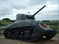
s (LST) were sunk in the engagement and 749 American servicemen died on that night. Over 1,000 lives were lost over the course of the operation. A Sherman amphibious tank
DD tank
DD tanks , were a type of amphibious swimming tank developed by the British during the Second World War...
and several plaques stand at Torcross car park between Slapton Ley and the beach as memorials to the men who lost their lives. The operation to salvage the tank from the shallow waters of Start Bay was financed by Ken Small, a Torcross hotelier, and was completed in 1984.
Storms and coastal erosion
Over the years Torcross has survived a battering from some terrible storms. On 4 January 1979 enormous waves washed over the roofs of the dwellings causing substantial damage; in the aftermath lorry-loads of boulders were brought in from the PlymouthPlymouth
Plymouth is a city and unitary authority area on the coast of Devon, England, about south-west of London. It is built between the mouths of the rivers Plym to the east and Tamar to the west, where they join Plymouth Sound...
area as temporary protection and a new curved seawall
Seawall
A seawall is a form of coastal defence constructed where the sea, and associated coastal processes, impact directly upon the landforms of the coast. The purpose of a seawall is to protect areas of human habitation, conservation and leisure activities from the action of tides and waves...
was built. On 11 and 12 January 2001 another bad storm caused the loss of up to five metres of the
beachhead along a stretch of beach about 1000 metres long. Part of the A379 road
A379 road
The A379 is a road in the English county of Devon. It links points on the edges of that county's two principal cities, Exeter and Plymouth, by an indirect and largely coastal route....
along Slapton Sands near the village was also destroyed; it was not reopened for three months. 3,000 tons of boulders were initially used to protect the road, but were later removed because of damage to the Slapton Ley SSSI.
The maintenance of the road is vital to Torcross as it is the main access route to Dartmouth for the villagers and local businesses. South Hams District Council is working to keep the A379 from being eroded, realigning the road and importing shingle from parts of Slapton Sands that have a surplus. A study by Natural England
English Nature
English Nature was the United Kingdom government agency that promoted the conservation of wildlife, geology and wild places throughout England between 1990 and 2006...
after the 2001 storm confirmed that because of the reduction in the amount of shingle available and the increasing frequency of storms, coupled with a predicted 30 to 40 cm rise in sea level over the next 50 years, Slapton Sands is retreating and will continue to retreat.