
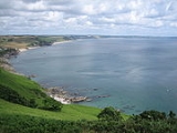
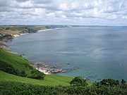
Start Bay
Encyclopedia
English Channel
The English Channel , often referred to simply as the Channel, is an arm of the Atlantic Ocean that separates southern England from northern France, and joins the North Sea to the Atlantic. It is about long and varies in width from at its widest to in the Strait of Dover...
in Devon
Devon
Devon is a large county in southwestern England. The county is sometimes referred to as Devonshire, although the term is rarely used inside the county itself as the county has never been officially "shired", it often indicates a traditional or historical context.The county shares borders with...
, England
England
England is a country that is part of the United Kingdom. It shares land borders with Scotland to the north and Wales to the west; the Irish Sea is to the north west, the Celtic Sea to the south west, with the North Sea to the east and the English Channel to the south separating it from continental...
between the River Dart
River Dart
The River Dart is a river in Devon, England which rises high on Dartmoor, and releases to the sea at Dartmouth. Its valley and surrounding area is a place of great natural beauty.-Watercourse:...
's estuary and Start Point
Start Point, Devon
Start Point is a promontory in the South Hams district. It is one of the most southerly points in Devon, England, . It marks the southern limit of Start Bay, which extends northwards to the estuary of the River Dart....
. On the coast, from south to north, are Hallsands, Beesands
Beesands
Beesands is located midway between Hallsands and Torcross in South Devon. Once a famous fishing village, it is now more important as a tourist destination with its setting on Start Bay. The local pub is famous for its crab sandwiches. There is an in the village dedicated to St Andrew...
, Torcross
Torcross
Torcross is a village in the South Hams district of Devon in England. It stands at grid reference at the southern end of Slapton Sands, a narrow strip of land and shingle beach which separates the freshwater lake of Slapton Ley from Start Bay and carries the A379 coastal road north to Dartmouth.-...
, the Slapton Sands, Strete, Blackpool Sands
Blackpool, Devon
There are two hamlets called Blackpool in Devon, England. These are near Plymouth and on Start Bay respectively....
and Stoke Fleming
Stoke Fleming
Stoke Fleming is a village and civil parish in the South Hams district of Devon, England. It lies on the A379 road about one and a half miles south of the town of Dartmouth, at the north end of Start Bay and within the South Devon Area of Outstanding Natural Beauty...
. The South West Coast Path
South West Coast Path
The South West Coast Path is Britain's longest waymarked long-distance footpath and a National Trail. It stretches for , running from Minehead in Somerset, along the coasts of Devon and Cornwall, to Poole Harbour in Dorset. Since it rises and falls with every river mouth, it is also one of the more...
covers much of the coastline.
Role in D-Day training
In preparing for the Normandy Invasion, the United States ArmyUnited States Army
The United States Army is the main branch of the United States Armed Forces responsible for land-based military operations. It is the largest and oldest established branch of the U.S. military, and is one of seven U.S. uniformed services...
conducted various training exercises at Slapton Sands in Start Bay and in the nearby Tor Bay, beginning on December 15, 1943. Slapton was an unspoiled beach of coarse gravel, fronting a shallow lagoon that was backed by bluffs that resembled Omaha Beach
Omaha Beach
Omaha Beach is the code name for one of the five sectors of the Allied invasion of German-occupied France in the Normandy landings on 6 June 1944, during World War II...
. After the people in the nearby village were evacuated, it was an almost perfect place to simulate the Normandy landings. The training was long and thorough. The culmination of the joint training program was a pair of full-scale rehearsals in late April and early May.