

Toqua (Tennessee)
Encyclopedia
Toqua is a prehistoric and historic Native American
site in Monroe County, Tennessee, located in the southeastern United States. Along with the Overhill Cherokee
village for which the site was named, Toqua was home to a substantial pre-Cherokee town that thrived during the Mississippian period
(1000-1600). One of the Toqua site's most outstanding features was a 25 feet (7.6 m) platform mound
built by the town's Mississippian inhabitants. The site's Mississippian occupation may have been the village of Tali, which was visited by the Hernando de Soto expedition in 1540.
The Toqua site is now submerged by Tellico Lake, an impoundment of the Little Tennessee River
. The lake is managed by the Tennessee Valley Authority
and the shoreline above the site is now a recreational area managed by the Tennessee Wildlife Resources Agency
.
, traverses northern Monroe County for roughly 40 miles (64.4 km) before emptying into the Tennessee River
near Lenoir City
. Tellico Lake, created in 1979 by the construction of Tellico Dam at the mouth of the Little Tennessee, covers the lower 33 miles (53.1 km) of the river and the lower 22 miles (35.4 km) of the Tellico River
. The Toqua site was situated along the south bank of the Little Tennessee at its confluence with Toqua Creek, approximately 22 miles (35.4 km) above the mouth of the river.
The shoreline above the now-submerged Toqua site comprises the Toqua Day Use Area Beach and Boat Ramp, which is situated along Tennessee State Route 360 approximately 2 miles (3.2 km) south of the road's junction with U.S. Route 411
at Vonore
. The site can be easily be observed from both the road and the boat ramp.
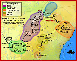 The Hernando de Soto expedition (1539–1543) most likely passed through the upper Tennessee Valley
en route to the Coosa chiefdom
in northern Georgia
. The expedition, seeking a passage to the Pacific Ocean, landed at Florida in May of 1539 and marched northward through what is now Georgia, South Carolina, and North Carolina before crossing the Blue Ridge Mountains
via the Nolichucky River
into the Tennessee Valley. After spending several weeks at Chiaha
(near modern Douglas Dam
), the expedition followed the French Broad River
and Tennessee River
to the village of Coste, which was on Bussell Island
at the mouth of the Little Tennessee River
. On July 9, 1540, the expedition left Coste, and followed the east bank of the Little Tennessee to the village of Tali, situated on the west bank of the river at what is now the Toqua site. The expedition's chroniclers noted that the river at this point was too deep to ford. The sight of the Spaniards nevertheless created a general panic in Tali, and the villagers attempted to flee downstream in canoes. De Soto apparently deployed his soldiers and forced the Talians to return. The chief of Tali gave the expedition four women and two porters, and the expedition departed southward the following day. The chief of Tali continued to send rations of sofkee (a gruel similar to hominy grits) and other food until the expedition reached Coosa on July 16.
word Dakwa'yi, meaning "fish place." The name was rooted in a Cherokee legend regarding the Dakwa, or "Great Fish," that lived at the mouth of Toqua Creek. Toqua first appears in the historical record in 1751, when it was listed as the base of a trader named Anthony Dean. In 1756, Toqua sent 30 warriors to aide the British during the French and Indian War
. Willanawaw, who was chief of Toqua at this time, had previously been listed as a chief of nearby Tanasi
. Henry Timberlake
, who visited the Overhill towns in 1761, noted that Willanawaw was still the headman at Toqua, and reported that the village was composed of 32 houses and a councilhouse. Toqua began to decline as Euro-American settlers pushed westward. The Overhill towns were repeatedly attacked during the American Revolution
and the Chickamauga Wars
(1776–1794), and Toqua itself was destroyed by John Sevier
in 1788.
In the late 1790s, the Duke of Orleans (and later king of France) Louis-Philippe
visited the Tellico Blockhouse
as part of extensive travels undertaken while he was in exile. Louis-Philippe reported a councilhouse surrounded by 8-10 houses at a site some 3 miles (4.8 km) south of the blockhouse, at what would have been the approximate location of Toqua, and gave a detailed description of the councilhouse's shape and composition.
Toqua still had a small population when the Cherokee sold their lands along the Little Tennessee to the U.S. government with the signing of the Calhoun Treaty in 1819. Shortly after the treaty, an early settler named John McGhee purchased several thousand acres along the Little Tennessee, including the Toqua site. McGhee's descendant's were still in possession of the property when the Tennessee Valley Authority began buying up the land for the creation of Tellico Reservoir in the 1960s.
One of the main goals of the University of Tennessee's Toqua investigation was to identify the connection, if any, between the Little Tennessee Valley's Mississippian-period inhabitants and its later Cherokee inhabitants. Other goals included the establishment of a more definite Cherokee period of occupation and to search for evidence of pre-Mississippian occupation.
(known as "Mound A") and 57 dwellings. A smaller mound, known as "Mound B," was located in the southeastern corner of the village. At its height around 1400, the village covered 4.8 acre (0.019424928 km²), although its size was later drastically reduced. The village was surrounded by a clay-covered palisade
with bastions located at 60 feet (18.3 m) intervals. Along with the village's layout, the excavation uncovered 477 confirmed human burials, 212 whole or partial ceramic vessels, and several thousand stone artifacts.
The Mississippian structures identified and investigated and the Toqua site included the two mounds and several dwellings. The construction of Mound A occurred in 16 phases and probably began in the 10th century. The mound was approximately 25 feet (7.6 m) high and 154 feet (46.9 m) in diameter, and topped by two structures, the largest of which measured 100 feet (30.5 m) x 83 feet (25.3 m) and contained a central hearth and benches. Excavations at the mound discovered a chert
sword, a pot filled with marsh elder seeds, and two high-status female burials. Mound B was 6 feet (1.8 m) high and 93 feet (28.3 m) in diameter, and contained numerous cremated human remains. A typical Mississippian-period dwelling at the Toqua site consisted of 400 square feet (37.2 m²) of living space, a central hearth, storage areas, and interior partitions.
Analysis of the human remains uncovered at Toqua determined that the height of the average male was 5'6" and the height of the average female was 5'1". Life expectancy was just 17.1 years for males and 15.1 years for females. Many of the remains showed signs of widespread iron-deficiency, possibly due to a diet relying too much upon corn and consisting of little meat. At its height, the village probably had a population of between 250 and 300.
Toqua was likely the dominant village in the Little Tennessee Valley between 1250 and 1500. An increase in mass burials and the reduction of the village to nearly one-half its size in the 16th century indicate a possible decline at Toqua. The village was superseded by rising Dallas Phase
occupations at Tomotley
(almost adjacent to Toqua) and Citico
(several miles upstream).
Native Americans in the United States
Native Americans in the United States are the indigenous peoples in North America within the boundaries of the present-day continental United States, parts of Alaska, and the island state of Hawaii. They are composed of numerous, distinct tribes, states, and ethnic groups, many of which survive as...
site in Monroe County, Tennessee, located in the southeastern United States. Along with the Overhill Cherokee
Overhill Cherokee
The term Overhill Cherokee refers to the former Cherokee settlements located in what is now Tennessee in the southeastern United States. The name was given by 18th century European traders and explorers who had to cross the Appalachian Mountains to reach these settlements when traveling from...
village for which the site was named, Toqua was home to a substantial pre-Cherokee town that thrived during the Mississippian period
Mississippian culture
The Mississippian culture was a mound-building Native American culture that flourished in what is now the Midwestern, Eastern, and Southeastern United States from approximately 800 CE to 1500 CE, varying regionally....
(1000-1600). One of the Toqua site's most outstanding features was a 25 feet (7.6 m) platform mound
Platform mound
A platform mound is any earthwork or mound intended to support a structure or activity.-Eastern North America:The indigenous peoples of North America built substructure mounds for well over a thousand years starting in the Archaic period and continuing through the Woodland period...
built by the town's Mississippian inhabitants. The site's Mississippian occupation may have been the village of Tali, which was visited by the Hernando de Soto expedition in 1540.
The Toqua site is now submerged by Tellico Lake, an impoundment of the Little Tennessee River
Little Tennessee River
The Little Tennessee River is a tributary of the Tennessee River, approximately 135 miles long, in the Appalachian Mountains in the southeastern United States.-Geography:...
. The lake is managed by the Tennessee Valley Authority
Tennessee Valley Authority
The Tennessee Valley Authority is a federally owned corporation in the United States created by congressional charter in May 1933 to provide navigation, flood control, electricity generation, fertilizer manufacturing, and economic development in the Tennessee Valley, a region particularly affected...
and the shoreline above the site is now a recreational area managed by the Tennessee Wildlife Resources Agency
Tennessee Wildlife Resources Agency
The Tennessee Wildlife Resources Agency is an independent state agency of the state of Tennessee with the mission of managing the state's fish and wildlife and their habitats, as well as responsibility for all wildlife-related law enforcement activities...
.
Geographical setting
The Little Tennessee River, which flows westward from its source in the Appalachian MountainsAppalachian Mountains
The Appalachian Mountains #Whether the stressed vowel is or ,#Whether the "ch" is pronounced as a fricative or an affricate , and#Whether the final vowel is the monophthong or the diphthong .), often called the Appalachians, are a system of mountains in eastern North America. The Appalachians...
, traverses northern Monroe County for roughly 40 miles (64.4 km) before emptying into the Tennessee River
Tennessee River
The Tennessee River is the largest tributary of the Ohio River. It is approximately 652 miles long and is located in the southeastern United States in the Tennessee Valley. The river was once popularly known as the Cherokee River, among other names...
near Lenoir City
Lenoir City, Tennessee
Lenoir City is a city in Loudon County, Tennessee, United States. Its population was 8,642 at the 2010 census. It is included in the Knoxville Metropolitan Area....
. Tellico Lake, created in 1979 by the construction of Tellico Dam at the mouth of the Little Tennessee, covers the lower 33 miles (53.1 km) of the river and the lower 22 miles (35.4 km) of the Tellico River
Tellico River
The Tellico River rises in the westernmost mountains of North Carolina, but it flows mainly through Monroe County, Tennessee. It is a major tributary of the Little Tennessee River and the namesake of Tellico Reservoir, a reservoir created by Tellico Dam, which impounds the lower reaches of the...
. The Toqua site was situated along the south bank of the Little Tennessee at its confluence with Toqua Creek, approximately 22 miles (35.4 km) above the mouth of the river.
The shoreline above the now-submerged Toqua site comprises the Toqua Day Use Area Beach and Boat Ramp, which is situated along Tennessee State Route 360 approximately 2 miles (3.2 km) south of the road's junction with U.S. Route 411
U.S. Route 411
U.S. Highway 411 is an alternate parallel-highway associated with U.S. Highway 11. U.S. 411 extends for about 313 miles from U.S. Route 78 in Leeds, Jefferson County, Alabama, to U.S. Highway 25 in Newport, Cocke County, Tennessee. U.S. 411 passes through the northeastern State of Alabama, the...
at Vonore
Vonore, Tennessee
Vonore is a town in Blount and Monroe counties in the U.S. state of Tennessee. The population was 1,162 as of the 2000 census.-Geography:Vonore is located at ....
. The site can be easily be observed from both the road and the boat ramp.
Protohistory
Tennessee Valley
The Tennessee Valley is the drainage basin of the Tennessee River and is largely within the U.S. state of Tennessee. It stretches from southwest Kentucky to northwest Georgia and from northeast Mississippi to the mountains of Virginia and North Carolina...
en route to the Coosa chiefdom
Coosa chiefdom
The Coosa chiefdom was a powerful Native American paramount chiefdom near what are now Gordon and Murray counties in Georgia, in the United States. It was inhabited from about 1400 until about 1600, and dominated several smaller chiefdoms...
in northern Georgia
Georgia (U.S. state)
Georgia is a state located in the southeastern United States. It was established in 1732, the last of the original Thirteen Colonies. The state is named after King George II of Great Britain. Georgia was the fourth state to ratify the United States Constitution, on January 2, 1788...
. The expedition, seeking a passage to the Pacific Ocean, landed at Florida in May of 1539 and marched northward through what is now Georgia, South Carolina, and North Carolina before crossing the Blue Ridge Mountains
Blue Ridge Mountains
The Blue Ridge Mountains are a physiographic province of the larger Appalachian Mountains range. This province consists of northern and southern physiographic regions, which divide near the Roanoke River gap. The mountain range is located in the eastern United States, starting at its southern-most...
via the Nolichucky River
Nolichucky River
The Nolichucky River is a major stream draining the Blue Ridge Mountains of western North Carolina and east Tennessee. The river is long.-Hydrography:...
into the Tennessee Valley. After spending several weeks at Chiaha
Chiaha
Chiaha was a horticultural Native American chiefdom located in the lower French Broad River valley in modern East Tennessee, in the southeastern United States. They lived in raised structures within boundaries of several stable villages. These overlooked the fields of maize, beans, squash, and...
(near modern Douglas Dam
Douglas Dam
Douglas Dam is a hydroelectric dam on the French Broad River in Sevier County, Tennessee, in the southeastern United States. The dam is operated by the Tennessee Valley Authority , which built the dam in record time in the early 1940s to meet emergency energy demands at the height of World War II...
), the expedition followed the French Broad River
French Broad River
The French Broad River flows from near the village of Rosman in Transylvania County, North Carolina, into the state of Tennessee. Its confluence with the Holston River at Knoxville is the beginning of the Tennessee River....
and Tennessee River
Tennessee River
The Tennessee River is the largest tributary of the Ohio River. It is approximately 652 miles long and is located in the southeastern United States in the Tennessee Valley. The river was once popularly known as the Cherokee River, among other names...
to the village of Coste, which was on Bussell Island
Bussell Island
Bussell Island, formerly Lenoir Island, is an island located at the mouth of the Little Tennessee River near the U.S. city of Lenoir City, Tennessee. The island was inhabited by various Native American cultures for thousands of years before the arrival of early European explorers, and is currently...
at the mouth of the Little Tennessee River
Little Tennessee River
The Little Tennessee River is a tributary of the Tennessee River, approximately 135 miles long, in the Appalachian Mountains in the southeastern United States.-Geography:...
. On July 9, 1540, the expedition left Coste, and followed the east bank of the Little Tennessee to the village of Tali, situated on the west bank of the river at what is now the Toqua site. The expedition's chroniclers noted that the river at this point was too deep to ford. The sight of the Spaniards nevertheless created a general panic in Tali, and the villagers attempted to flee downstream in canoes. De Soto apparently deployed his soldiers and forced the Talians to return. The chief of Tali gave the expedition four women and two porters, and the expedition departed southward the following day. The chief of Tali continued to send rations of sofkee (a gruel similar to hominy grits) and other food until the expedition reached Coosa on July 16.
The Cherokee period
The name "Toqua" comes from the CherokeeCherokee language
Cherokee is an Iroquoian language spoken by the Cherokee people which uses a unique syllabary writing system. It is the only Southern Iroquoian language that remains spoken. Cherokee is a polysynthetic language.-North American etymology:...
word Dakwa'yi, meaning "fish place." The name was rooted in a Cherokee legend regarding the Dakwa, or "Great Fish," that lived at the mouth of Toqua Creek. Toqua first appears in the historical record in 1751, when it was listed as the base of a trader named Anthony Dean. In 1756, Toqua sent 30 warriors to aide the British during the French and Indian War
French and Indian War
The French and Indian War is the common American name for the war between Great Britain and France in North America from 1754 to 1763. In 1756, the war erupted into the world-wide conflict known as the Seven Years' War and thus came to be regarded as the North American theater of that war...
. Willanawaw, who was chief of Toqua at this time, had previously been listed as a chief of nearby Tanasi
Tanasi
Tanasi is a historic Overhill Cherokee village site in Monroe County, Tennessee, in the southeastern United States. The village is best known as the namesake for the state of Tennessee...
. Henry Timberlake
Henry Timberlake
Henry Timberlake was a colonial Anglo-American officer, journalist, and cartographer. He was born in Virginia in 1730 and died in England...
, who visited the Overhill towns in 1761, noted that Willanawaw was still the headman at Toqua, and reported that the village was composed of 32 houses and a councilhouse. Toqua began to decline as Euro-American settlers pushed westward. The Overhill towns were repeatedly attacked during the American Revolution
American Revolutionary War
The American Revolutionary War , the American War of Independence, or simply the Revolutionary War, began as a war between the Kingdom of Great Britain and thirteen British colonies in North America, and ended in a global war between several European great powers.The war was the result of the...
and the Chickamauga Wars
Chickamauga wars
The Chickamauga Wars were a series of raids, campaigns, ambushes, minor skirmishes, and several full-scale frontier battles which were a continuation of the Cherokee struggle against encroachment by American frontiersmen from the former British colonies...
(1776–1794), and Toqua itself was destroyed by John Sevier
John Sevier
John Sevier served four years as the only governor of the State of Franklin and twelve years as Governor of Tennessee. As a U.S. Representative from Tennessee from 1811 until his death...
in 1788.
In the late 1790s, the Duke of Orleans (and later king of France) Louis-Philippe
Louis-Philippe of France
Louis Philippe I was King of the French from 1830 to 1848 in what was known as the July Monarchy. His father was a duke who supported the French Revolution but was nevertheless guillotined. Louis Philippe fled France as a young man and spent 21 years in exile, including considerable time in the...
visited the Tellico Blockhouse
Tellico Blockhouse
The Tellico Blockhouse was an early American outpost located along the Little Tennessee River in Vonore, Monroe County, Tennessee. Completed in 1794, the blockhouse operated until 1807 with the purpose of keeping the peace between nearby Overhill Cherokee towns and early Euro-American settlers in...
as part of extensive travels undertaken while he was in exile. Louis-Philippe reported a councilhouse surrounded by 8-10 houses at a site some 3 miles (4.8 km) south of the blockhouse, at what would have been the approximate location of Toqua, and gave a detailed description of the councilhouse's shape and composition.
Toqua still had a small population when the Cherokee sold their lands along the Little Tennessee to the U.S. government with the signing of the Calhoun Treaty in 1819. Shortly after the treaty, an early settler named John McGhee purchased several thousand acres along the Little Tennessee, including the Toqua site. McGhee's descendant's were still in possession of the property when the Tennessee Valley Authority began buying up the land for the creation of Tellico Reservoir in the 1960s.
Archaeological work at Toqua
John W. Emmert, working for the Bureau of Ethnology, conducted the first archaeological survey of the Toqua area in 1884. In the 1930s, a treasure hunter named George Barnes uncovered hundreds of human bones— most of which he discarded— while digging for artifacts at the Toqua site. In 1967, in anticipation of the flooding of the site by the construction of Tellico Dam, the University of Tennessee Department of Anthropology began an initial survey of the area to locate sites for further research. Toqua was chosen for excavation as the valley's last remaining Dallas-phase mound site.One of the main goals of the University of Tennessee's Toqua investigation was to identify the connection, if any, between the Little Tennessee Valley's Mississippian-period inhabitants and its later Cherokee inhabitants. Other goals included the establishment of a more definite Cherokee period of occupation and to search for evidence of pre-Mississippian occupation.
Toqua's Mississippian period inhabitants
Excavations at Toqua in the 1970s uncovered evidence typical of a Mississippian period village. The village consisted of a central pebble-covered plaza flanked by a large "platform" moundPlatform mound
A platform mound is any earthwork or mound intended to support a structure or activity.-Eastern North America:The indigenous peoples of North America built substructure mounds for well over a thousand years starting in the Archaic period and continuing through the Woodland period...
(known as "Mound A") and 57 dwellings. A smaller mound, known as "Mound B," was located in the southeastern corner of the village. At its height around 1400, the village covered 4.8 acre (0.019424928 km²), although its size was later drastically reduced. The village was surrounded by a clay-covered palisade
Palisade
A palisade is a steel or wooden fence or wall of variable height, usually used as a defensive structure.- Typical construction :Typical construction consisted of small or mid sized tree trunks aligned vertically, with no spacing in between. The trunks were sharpened or pointed at the top, and were...
with bastions located at 60 feet (18.3 m) intervals. Along with the village's layout, the excavation uncovered 477 confirmed human burials, 212 whole or partial ceramic vessels, and several thousand stone artifacts.
The Mississippian structures identified and investigated and the Toqua site included the two mounds and several dwellings. The construction of Mound A occurred in 16 phases and probably began in the 10th century. The mound was approximately 25 feet (7.6 m) high and 154 feet (46.9 m) in diameter, and topped by two structures, the largest of which measured 100 feet (30.5 m) x 83 feet (25.3 m) and contained a central hearth and benches. Excavations at the mound discovered a chert
Chert
Chert is a fine-grained silica-rich microcrystalline, cryptocrystalline or microfibrous sedimentary rock that may contain small fossils. It varies greatly in color , but most often manifests as gray, brown, grayish brown and light green to rusty red; its color is an expression of trace elements...
sword, a pot filled with marsh elder seeds, and two high-status female burials. Mound B was 6 feet (1.8 m) high and 93 feet (28.3 m) in diameter, and contained numerous cremated human remains. A typical Mississippian-period dwelling at the Toqua site consisted of 400 square feet (37.2 m²) of living space, a central hearth, storage areas, and interior partitions.
Analysis of the human remains uncovered at Toqua determined that the height of the average male was 5'6" and the height of the average female was 5'1". Life expectancy was just 17.1 years for males and 15.1 years for females. Many of the remains showed signs of widespread iron-deficiency, possibly due to a diet relying too much upon corn and consisting of little meat. At its height, the village probably had a population of between 250 and 300.
Toqua was likely the dominant village in the Little Tennessee Valley between 1250 and 1500. An increase in mass burials and the reduction of the village to nearly one-half its size in the 16th century indicate a possible decline at Toqua. The village was superseded by rising Dallas Phase
Dallas Phase
Dallas Phase is an archaeological phase, within the Mississippian III period, in the South Appalachian Geologic province.-Geography:Dallas peoples moved into southwest Virginia from northeastern Tennessee in the early 13th century...
occupations at Tomotley
Tomotley
Tomotley is a prehistoric and historic Native American site in Monroe County, Tennessee, in the southeastern United States. Occupied as early as the Archaic period, the Tomotley site had the most substantial periods of habitation during the Mississippian period, likely when the earthwork mounds...
(almost adjacent to Toqua) and Citico
Citico (Tellico archaeological site)
Citico is a prehistoric and historic Native American site in Monroe County, Tennessee, in the southeastern United States. The site's namesake Cherokee village was the largest of the Overhill towns, housing an estimated population of 1,000 by the mid-18th century...
(several miles upstream).
Conclusions
While excavators were able to establish a rough period of Cherokee occupation at Toqua by matching archaeological finds with historical data, the project's main goal— identifying the relationship between Toqua's Cherokee and pre-Cherokee inhabitants— remained inconclusive. Investigators found no evidence of a "continued" occupation from the Mississippian period to the Overhill period, and the link between the Cherokee and pre-Cherokee inhabitants of the Little Tennessee Valley remains an unresolved issue.See also
- List of sites and peoples visited by the Hernando de Soto Expedition
- Mississippian cultureMississippian cultureThe Mississippian culture was a mound-building Native American culture that flourished in what is now the Midwestern, Eastern, and Southeastern United States from approximately 800 CE to 1500 CE, varying regionally....
- Southeastern Ceremonial ComplexSoutheastern Ceremonial ComplexThe Southeastern Ceremonial Complex is the name given to the regional stylistic similarity of artifacts, iconography, ceremonies, and mythology of the Mississippian culture that coincided with their adoption of maize agriculture and chiefdom-level complex social organization from...
External links
- Frank H. McClung Museum
- The Toqua townhouse's hearth — photograph of the central hearth in Toqua's Cherokee townhouse (councilhouse)
- Tellico Lake Wildlife Management Area — TWRA site