

Topographical areas of Yorkshire
Encyclopedia
North York Moors
The North York Moors is a national park in North Yorkshire, England. The moors are one of the largest expanses of heather moorland in the United Kingdom. It covers an area of , and it has a population of about 25,000...
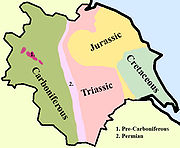
in the north-east of the county are Jurassic in age while the Yorkshire Wolds
Yorkshire Wolds
The Yorkshire Wolds are low hills in the counties of East Riding of Yorkshire and North Yorkshire in northeastern England. The name also applies to the district in which the hills lie....
to the south east are Cretaceous chalk uplands. The plain of Holderness
Holderness
Holderness is an area of the East Riding of Yorkshire, on the east coast of England. An area of rich agricultural land, Holderness was marshland until it was drained in the Middle Ages. Topographically, Holderness has more in common with the Netherlands than other parts of Yorkshire...
and the Humberhead levels both owe their present form to the Quaternary ice ages.
Much of Yorkshire presents heavily glaciated scenery as few places escaped the great ice sheets as they advanced during the last ice age.
Drainage
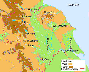
Western and central Yorkshire are largely drained by rivers which empty their waters into the River OuseRiver Ouse, Yorkshire
The River Ouse is a river in North Yorkshire, England. The river is formed from the River Ure at Cuddy Shaw Reach near Linton-on-Ouse, about 6 miles downstream of the confluence of the River Swale with the River Ure...
which reaches the North Sea via the Humber Estuary.
Swaledale
Swaledale is one of the northernmost dales in the Yorkshire Dales National Park in northern England. It is the dale of the River Swale on the east side of the Pennines in North Yorkshire.-Geographical overview:...
before passing through Richmond
Richmond, North Yorkshire
Richmond is a market town and civil parish on the River Swale in North Yorkshire, England and is the administrative centre of the district of Richmondshire. It is situated on the edge of the Yorkshire Dales National Park, and serves as the Park's main tourist centre...
and meandering across the Vale of Mowbray
Vale of Mowbray
The Vale of Mowbray is a stretch of low lying land between the North Yorkshire Moors and the Hambleton Hills to the east and the Yorkshire Dales to the west...
. Next, draining Wensleydale
Wensleydale
Wensleydale is the valley of the River Ure on the east side of the Pennines in North Yorkshire, England.Wensleydale lies in the Yorkshire Dales National Park – one of only a few valleys in the Dales not currently named after its principal river , but the older name, "Yoredale", can still be seen...
, is the River Ure
River Ure
The River Ure is a river in North Yorkshire, England, approximately long from its source to the point where it changes name to the River Ouse. It is the principal river of Wensleydale, which is the only one of the Dales now named after a village rather than its river...
, which joins the Swale east of Boroughbridge. The River Nidd
River Nidd
The River Nidd is a tributary of the River Ouse in the English county of North Yorkshire. In its first few miles it is dammed three times to create Angram Reservoir, Scar House Reservoir and Gouthwaite Reservoir which attract around 150,000 visitors a year...
rises on the edge of the Yorkshire Dales National Park and flows along Nidderdale
Nidderdale
Nidderdale is one of the Yorkshire Dales in North Yorkshire, England. It is the upper valley of the River Nidd, which flows south through the dale, forming several reservoirs including the Gouthwaite Reservoir, before turning east and eventually joining the River Ouse.The only town in the dale is...
before reaching the Vale of York
Vale of York
The Vale of York is an area of flat land in the north-east of England. The vale is a major agricultural area and serves as the main north-south transport corridor for northern England....
. The Ouse is the name given to the river after its confluence with the Ure at Ouse Gill Beck. The River Wharfe
River Wharfe
The River Wharfe is a river in Yorkshire, England. For much of its length it is the county boundary between West Yorkshire and North Yorkshire. The name Wharfe is Celtic and means "twisting, winding".The valley of the River Wharfe is known as Wharfedale...
, which drains Wharfedale
Wharfedale
Wharfedale is one of the Yorkshire Dales in England. It is the valley of the River Wharfe. Towns and villages in Wharfedale include Buckden, Kettlewell, Conistone, Grassington, Hebden, Ilkley, Burley-in-Wharfedale, Otley, Pool-in-Wharfedale, Arthington, Collingham, and Wetherby...
, joins the Ouse upstream of Cawood. The Rivers Aire and Calder are more southerly contributors to the River Ouse and the most southerly Yorkshire tributary is the River Don, which flows northwards to join the main river at Goole
Goole
Goole is a town, civil parish and port located approximately inland on the confluence of the rivers Don and Ouse in the East Riding of Yorkshire, England...
.
In the far north of the county the River Tees
River Tees
The River Tees is in Northern England. It rises on the eastern slope of Cross Fell in the North Pennines, and flows eastwards for 85 miles to reach the North Sea between Hartlepool and Redcar.-Geography:...
flows easteards through Teesdale
Teesdale
Teesdale is a dale, or valley, of the east side of the Pennines in England. Large parts of Teesdale fall within the North Pennines Area of Outstanding Natural Beauty - the second largest AONB in England and Wales. The River Tees rises below Cross Fell, the highest hill in the Pennines, and its...
and empties its waters into the North Sea downstream of Middlesbrough. The smaller River Esk flows from west to east at the northern foot of the North York Moors to reach the sea at Whitby.
The River Derwent
River Derwent, Yorkshire
The Derwent is a river in Yorkshire in the north of England. It is used for water abstraction, leisure and sporting activities and effluent disposal as well as being of significant importance as the site of several nature reserves...
rises on the North York Moors, flows south then westwards through the Vale of Pickering
Vale of Pickering
The Vale of Pickering is a low-lying flat area of land in North Yorkshire, England. It is drained by the River Derwent. The landscape is rural with scattered villages and small market towns. It has been inhabited continuously from the Mesolithic period...
then turns south again to drain the eastern part of the Vale of York. It empties into the River Ouse at Barmby on the Marsh. To the east of the Yorkshire Wolds the River Hull
River Hull
The River Hull is a navigable river in the East Riding of Yorkshire in the north of England. It rises from a series of springs to the west of Driffield, and enters the Humber estuary at Kingston upon Hull. Following a period when the Archbishops of York charged tolls for its use, it became a free...
flows southwards to join the Humber Estuary at Kingston upon Hull. The western Pennines are served by the River Ribble
River Ribble
The River Ribble is a river that runs through North Yorkshire and Lancashire, in northern England. The river's drainage basin also includes parts of Greater Manchester around Wigan.-Geography:...
which drains westwards into the Irish Sea close to Lytham St Anne’s.
Natural Areas
Natural England, the name given to the body responsible to the UK government for natural affairs has defined 14 distinctive Natural Areas in Yorkshire.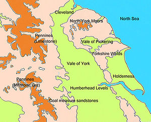
- Yorkshire DalesYorkshire DalesThe Yorkshire Dales is the name given to an upland area in Northern England.The area lies within the historic county boundaries of Yorkshire, though it spans the ceremonial counties of North Yorkshire, West Yorkshire and Cumbria...
(16) - Southern Pennines (12)
- Pennine Dales Fringe (15)
- Vale of YorkVale of YorkThe Vale of York is an area of flat land in the north-east of England. The vale is a major agricultural area and serves as the main north-south transport corridor for northern England....
and Mowbray (1&8) - North York MoorsNorth York MoorsThe North York Moors is a national park in North Yorkshire, England. The moors are one of the largest expanses of heather moorland in the United Kingdom. It covers an area of , and it has a population of about 25,000...
and Hills (13) - Vale of PickeringVale of PickeringThe Vale of Pickering is a low-lying flat area of land in North Yorkshire, England. It is drained by the River Derwent. The landscape is rural with scattered villages and small market towns. It has been inhabited continuously from the Mesolithic period...
(2) - Yorkshire WoldsYorkshire WoldsThe Yorkshire Wolds are low hills in the counties of East Riding of Yorkshire and North Yorkshire in northeastern England. The name also applies to the district in which the hills lie....
(4) - HoldernessHoldernessHolderness is an area of the East Riding of Yorkshire, on the east coast of England. An area of rich agricultural land, Holderness was marshland until it was drained in the Middle Ages. Topographically, Holderness has more in common with the Netherlands than other parts of Yorkshire...
(5) - Humberhead LevelsHumberhead LevelsThe Humberhead Levels cover a large expanse of very flat, low lying land towards the eastern end of the Humber estuary in northern England. The Levels occupies the area of the former Glacial Lake Humber...
(7) - Southern Magnesian LimestoneDolostoneDolostone or dolomite rock is a sedimentary carbonate rock that contains a high percentage of the mineral dolomite. In old U.S.G.S. publications it was referred to as magnesian limestone. Most dolostone formed as a magnesium replacement of limestone or lime mud prior to lithification. It is...
(9) - Coal Measures (10)
- Humber Estuary
- Saltburn to Bridlington
- Bridlington to Skegness
(Figures in brackets refer to the equivalent Joint Character Areas outlined in the next section and illustrated on the map there.)
Natural Areas are defined as “biogeographic zones which reflect the geographic foundation, the natural systems and processes, and the wildlife in different parts of England, and provide a framework for setting objectives for nature conservation.”
Joint Character Areas
The Natural Areas concept was further refined by the Joint Nature Concervancy Council in their definition of Joint Character Areas. These used Natural Areas for their basis but added other defining characteristics such as historical associations to produce a list of characteristic areas within the county.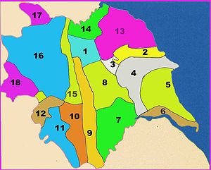
- Vale of MowbrayVale of MowbrayThe Vale of Mowbray is a stretch of low lying land between the North Yorkshire Moors and the Hambleton Hills to the east and the Yorkshire Dales to the west...
- Vale of PickeringVale of PickeringThe Vale of Pickering is a low-lying flat area of land in North Yorkshire, England. It is drained by the River Derwent. The landscape is rural with scattered villages and small market towns. It has been inhabited continuously from the Mesolithic period...
- Howardian HillsHowardian HillsThe Howardian Hills form an Area of Outstanding Natural Beauty in North Yorkshire, England. located between the Yorkshire Wolds, the North York Moors National Park and the Vale of York. The AONB includes farmland, wooded rolling countryside, villages and historic houses with parkland...
- Yorkshire WoldsYorkshire WoldsThe Yorkshire Wolds are low hills in the counties of East Riding of Yorkshire and North Yorkshire in northeastern England. The name also applies to the district in which the hills lie....
- HoldernessHoldernessHolderness is an area of the East Riding of Yorkshire, on the east coast of England. An area of rich agricultural land, Holderness was marshland until it was drained in the Middle Ages. Topographically, Holderness has more in common with the Netherlands than other parts of Yorkshire...
- Humber Estuary
- Humberhead LevelsHumberhead LevelsThe Humberhead Levels cover a large expanse of very flat, low lying land towards the eastern end of the Humber estuary in northern England. The Levels occupies the area of the former Glacial Lake Humber...
- Vale of YorkVale of YorkThe Vale of York is an area of flat land in the north-east of England. The vale is a major agricultural area and serves as the main north-south transport corridor for northern England....
- Southern Magnesian LimestoneDolostoneDolostone or dolomite rock is a sedimentary carbonate rock that contains a high percentage of the mineral dolomite. In old U.S.G.S. publications it was referred to as magnesian limestone. Most dolostone formed as a magnesium replacement of limestone or lime mud prior to lithification. It is...
- Nottinghamshire, Derbyshire and Yorkshire Coalfield
- Yorkshire Southern Pennine Fringe
- Southern Pennines
- North Yorkshire Moors and Cleveland HillsCleveland HillsThe Cleveland Hills are a range of hills on the north-west edge of the North York Moors in North Yorkshire, England, overlooking Cleveland and Teesside. They lie entirely within the boundaries of the North York Moors National Park. Part of the long Cleveland Way National Trail runs along the...
- Tees Lowlands
- Pennine Dales Fringe
- Yorkshire DalesYorkshire DalesThe Yorkshire Dales is the name given to an upland area in Northern England.The area lies within the historic county boundaries of Yorkshire, though it spans the ceremonial counties of North Yorkshire, West Yorkshire and Cumbria...
- North PenninesNorth PenninesThe North Pennines is the northernmost section of the Pennine range of hills which runs north-south through northern England. It lies between Carlisle to the west and Darlington to the east...
- Bowland FellsForest of BowlandThe Forest of Bowland, also known as the Bowland Fells, is an area of barren gritstone fells, deep valleys and peat moorland, mostly in north-east Lancashire, England. A small part lies in North Yorkshire, and much of the area was historically part of the West Riding of Yorkshire...
Areas of Outstanding Natural Beauty
- NidderdaleNidderdaleNidderdale is one of the Yorkshire Dales in North Yorkshire, England. It is the upper valley of the River Nidd, which flows south through the dale, forming several reservoirs including the Gouthwaite Reservoir, before turning east and eventually joining the River Ouse.The only town in the dale is...
- North PenninesNorth PenninesThe North Pennines is the northernmost section of the Pennine range of hills which runs north-south through northern England. It lies between Carlisle to the west and Darlington to the east...
- Howardian HillsHowardian HillsThe Howardian Hills form an Area of Outstanding Natural Beauty in North Yorkshire, England. located between the Yorkshire Wolds, the North York Moors National Park and the Vale of York. The AONB includes farmland, wooded rolling countryside, villages and historic houses with parkland...
Nature Reserves
- RSPB Bempton Cliffs
- RSPB Blacktoft Sands
- RSPB Fairburn IngsRSPB Fairburn IngsFairburn Ings RSPB reserve is a flagship RSPB nature reserve in the county of West Yorkshire, England; established in 1968. It is managed by the Royal Society for the Protection of Birds in conjunction with the local council....
- RSPB Old MoorRSPB Old Moor Wetland CentreRSPB Old Moor is a wetlands nature reserve in Barnsley, England run by the Royal Society for the Protection of Birds . It lies on the junction of the north/south and east/west routes of the Trans Pennine Trail...
- YWT North Cave Wetlands
- YWT Potteric CarrPotteric Carr Nature ReservePotteric Carr Nature Reserve is a nature reserve at Potteric Carr, south of Doncaster, South Yorkshire, England and managed by the Yorkshire Wildlife Trust as their flagship - and largest - reserve....
- YWT Spurn PointSpurnSpurn Point is a narrow sand spit on the tip of the coast of the East Riding of Yorkshire, England that reaches into the North Sea and forms the north bank of the mouth of the Humber estuary. It is over long, almost half the width of the estuary at that point, and as little as wide in places...
- YWT Wheldrake Ings