
Top o'Selside
Encyclopedia
Top o'Selside is a hill in the Lake District
in Cumbria
, England
. At 335 m, it is the highest point of the group of hills situated between Coniston Water
and Windermere
. This group also includes the Wainwright of Black Fell
and the summits of Black Brows and Rusland Heights. Top o'Selside lies not in the centre of this region, but in the south-western corner, just outside the forestry plantations of Grizedale Forest
and only two-thirds of a mile from the eastern shore of Coniston Water. This large separation from any higher ground gives it enough relative height to make it a Marilyn
.
, where the author gives a walk from High Nibthwaite over the subsidiary summits of High and Low Light Haw. This walk is a little over four miles and involves about a thousand feet of climb. Wainwright's location is not the highest point of the fell, being 100m to the west of the true summit and 1m lower.
The western slopes (named Selside, from which the hill derives its name) are entirely forested, but a path zigzags up the steep fellside from a parking area at grid ref. SD 299927. This provides the shortest route to the summit and is two miles long (there and back).
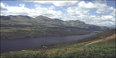
The view is very impressive, including a full-length view of Coniston Water. The Old Man of Coniston
, Black Combe
, the Helvellyn
and High Street
groups all feature prominently, as well as Ingleborough
in the Yorkshire Dales
.
is held in the moraines left by two glacier
s moving down each valley. He also says the area was populated by lawless brigands
in the 14th Century led by Adam de Beaumont. They held the neighbourhood in terror for seventeen years between 1346 to 1363 when they were finally caught. Arnesbarrow is a Norse name meaning burial place or stronghold of Arne.
Lake District
The Lake District, also commonly known as The Lakes or Lakeland, is a mountainous region in North West England. A popular holiday destination, it is famous not only for its lakes and its mountains but also for its associations with the early 19th century poetry and writings of William Wordsworth...
in Cumbria
Cumbria
Cumbria , is a non-metropolitan county in North West England. The county and Cumbria County Council, its local authority, came into existence in 1974 after the passage of the Local Government Act 1972. Cumbria's largest settlement and county town is Carlisle. It consists of six districts, and in...
, England
England
England is a country that is part of the United Kingdom. It shares land borders with Scotland to the north and Wales to the west; the Irish Sea is to the north west, the Celtic Sea to the south west, with the North Sea to the east and the English Channel to the south separating it from continental...
. At 335 m, it is the highest point of the group of hills situated between Coniston Water
Coniston Water
Coniston Water in Cumbria, England is the third largest lake in the English Lake District. It is five miles long, half a mile wide, has a maximum depth of 184 feet , and covers an area of . The lake has an elevation of 143 feet above sea level...
and Windermere
Windermere (lake)
Windermere is the largest natural lake in England. It is a ribbon lake formed in a glacial trough after the retreat of ice at the start of the current interglacial. It has been one of the country’s most popular places for holidays and summer homes since the arrival of the Kendal and Windermere...
. This group also includes the Wainwright of Black Fell
Black Fell (Lake District)
Black Fell is a fell in the English Lake District. It rises to the north of Tarn Hows, between Coniston and Hawkshead.-Topography:Black Fell is the high point in the hilly area bounded by Windermere, Langdale and Coniston. It occupies an area of around one mile by two, clad mainly in fell grass...
and the summits of Black Brows and Rusland Heights. Top o'Selside lies not in the centre of this region, but in the south-western corner, just outside the forestry plantations of Grizedale Forest
Grizedale Forest
Grizedale Forest is a 24.47 km² area of woodland in the Lake District of North West England, located to the east of Coniston Water and to the south of Hawkshead. It comprises a number of hills, small tarns and the settlements of Grizedale and Satterthwaite...
and only two-thirds of a mile from the eastern shore of Coniston Water. This large separation from any higher ground gives it enough relative height to make it a Marilyn
Marilyn (hill)
A Marilyn is a mountain or hill in the United Kingdom, Republic of Ireland or Isle of Man with a relative height of at least 150 metres , regardless of absolute height or other merit...
.
Ascents
It is also listed in A. Wainwright's Pictorial Guide to the Outlying FellsThe Outlying Fells of Lakeland
The Outlying Fells of Lakeland is a book written by Alfred Wainwright, dealing with hills in and around the Lake District of England. It differs from Wainwright's Pictorial Guides in that it describes a series of walks, some of them taking in several summits, rather than devoting a chapter to each...
, where the author gives a walk from High Nibthwaite over the subsidiary summits of High and Low Light Haw. This walk is a little over four miles and involves about a thousand feet of climb. Wainwright's location is not the highest point of the fell, being 100m to the west of the true summit and 1m lower.
The western slopes (named Selside, from which the hill derives its name) are entirely forested, but a path zigzags up the steep fellside from a parking area at grid ref. SD 299927. This provides the shortest route to the summit and is two miles long (there and back).
The view is very impressive, including a full-length view of Coniston Water. The Old Man of Coniston
Old Man of Coniston
The Old Man of Coniston is a fell in the Furness Fells in the English Lake District. It is high, and lies to the west of the village of Coniston and the lake of the same name, Coniston Water. The fell is sometimes known by the alternate name of Coniston Old Man, or simply The Old Man...
, Black Combe
Black Combe
Black Combe is a fell in the south-west corner of the Lake District National Park, just four miles from the Irish Sea. It lies near the west coast of Cumbria in the borough of Copeland and more specifically, an area known as South Copeland...
, the Helvellyn
Helvellyn
Helvellyn is a mountain in the English Lake District, the apex of the Eastern Fells. At above sea level, it is the third highest peak in both the Lake District and England...
and High Street
High Street (Lake District)
High Street is a fell in the English Lake District. At 828 metres , its summit is the highest point in the far eastern part of the national park. The fell is named after the Roman road which ran over the summit.-History and Naming:...
groups all feature prominently, as well as Ingleborough
Ingleborough
Ingleborough is the second highest mountain in the Yorkshire Dales. It is one of the Yorkshire Three Peaks, the other two being Whernside and Pen-y-ghent. Ingleborough is frequently climbed as part of the Yorkshire Three Peaks Challenge, which is a 24-mile circular challenge walk starting and...
in the Yorkshire Dales
Yorkshire Dales
The Yorkshire Dales is the name given to an upland area in Northern England.The area lies within the historic county boundaries of Yorkshire, though it spans the ceremonial counties of North Yorkshire, West Yorkshire and Cumbria...
.
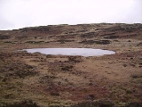
Tarn
There is a small sheet of water to the south of the summit, Arnsbarrow Tarn (pictured above). According to Heaton Cooper the tarnTarn (lake)
A tarn is a mountain lake or pool, formed in a cirque excavated by a glacier. A moraine may form a natural dam below a tarn. A corrie may be called a cirque.The word is derived from the Old Norse word tjörn meaning pond...
is held in the moraines left by two glacier
Glacier
A glacier is a large persistent body of ice that forms where the accumulation of snow exceeds its ablation over many years, often centuries. At least 0.1 km² in area and 50 m thick, but often much larger, a glacier slowly deforms and flows due to stresses induced by its weight...
s moving down each valley. He also says the area was populated by lawless brigands
Outlaw
In historical legal systems, an outlaw is declared as outside the protection of the law. In pre-modern societies, this takes the burden of active prosecution of a criminal from the authorities. Instead, the criminal is withdrawn all legal protection, so that anyone is legally empowered to persecute...
in the 14th Century led by Adam de Beaumont. They held the neighbourhood in terror for seventeen years between 1346 to 1363 when they were finally caught. Arnesbarrow is a Norse name meaning burial place or stronghold of Arne.