
Thornton Gap
Encyclopedia
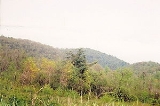
Thornton Gap is a wind gap
located in the Blue Ridge Mountains
in Virginia
separating the Shenandoah Valley
from the Piedmont
region of the state.
in Rappahannock County
.
The privately-owned Thornton's Gap Turnpike Company was formed to build a road over the mountains at Thornton's Gap. The toll road
opened in 1806.
Thornton Gap was one of the passages through the Blue Ridge Mountains between the Shenandoah Valley and the Piedmont region of Virginia used by Confederate
General Stonewall Jackson
to move his famous "foot cavalry
" troops during the American Civil War
.
Prior to the building of the Shenandoah National Park
and the Skyline Drive
by the federal Works Progress Administration
(WPA) during the Great Depression
, the lost town of Beahm was located at Thornton Gap.
Sculptor William Randolph Barbee
was the son of a toll collector at Thornton Gap; his son Herbert
later erected a bust in his memory at the site.
and Rappahannock County
. At Thornton Gap, there is an entry point for the bucolic Skyline Drive
, which runs between Front Royal
and the northern terminus with the Blue Ridge Parkway
at Rockfish Gap
. The Skyline Drive generally following the mountain ridge tops through the Shenandoah National Park
, which has its headquarters near Thornton Gap in the Town of Luray
. The Appalachian Trail
also passes through Thornton Gap.
Wind gap
A wind gap is a valley through which a waterway once flowed, but is now dry as a result of stream capture. A water gap is a similar feature, but one in which a waterway still flows...
located in the Blue Ridge Mountains
Blue Ridge Mountains
The Blue Ridge Mountains are a physiographic province of the larger Appalachian Mountains range. This province consists of northern and southern physiographic regions, which divide near the Roanoke River gap. The mountain range is located in the eastern United States, starting at its southern-most...
in Virginia
Virginia
The Commonwealth of Virginia , is a U.S. state on the Atlantic Coast of the Southern United States. Virginia is nicknamed the "Old Dominion" and sometimes the "Mother of Presidents" after the eight U.S. presidents born there...
separating the Shenandoah Valley
Shenandoah Valley
The Shenandoah Valley is both a geographic valley and cultural region of western Virginia and West Virginia in the United States. The valley is bounded to the east by the Blue Ridge Mountains, to the west by the eastern front of the Ridge-and-Valley Appalachians , to the north by the Potomac River...
from the Piedmont
Piedmont (United States)
The Piedmont is a plateau region located in the eastern United States between the Atlantic Coastal Plain and the main Appalachian Mountains, stretching from New Jersey in the north to central Alabama in the south. The Piedmont province is a physiographic province of the larger Appalachian division...
region of the state.
History
Thornton Gap was named for Francis Thornton (1711–April 14, 1749), owner of the land to the east and the "F.T. Valley". In 1740, he built a mansion in the Piedmont region near NethersNethers, Virginia
-References:*...
in Rappahannock County
Rappahannock County, Virginia
As of the census of 2010, there were 7,373 people, 2,788 households, and 2,004 families residing in the county. The population density was 26 people per square mile . There were 3,303 housing units at an average density of 12 per square mile...
.
The privately-owned Thornton's Gap Turnpike Company was formed to build a road over the mountains at Thornton's Gap. The toll road
Toll road
A toll road is a privately or publicly built road for which a driver pays a toll for use. Structures for which tolls are charged include toll bridges and toll tunnels. Non-toll roads are financed using other sources of revenue, most typically fuel tax or general tax funds...
opened in 1806.
Thornton Gap was one of the passages through the Blue Ridge Mountains between the Shenandoah Valley and the Piedmont region of Virginia used by Confederate
Confederate States of America
The Confederate States of America was a government set up from 1861 to 1865 by 11 Southern slave states of the United States of America that had declared their secession from the U.S...
General Stonewall Jackson
Stonewall Jackson
ຄຽשת״ׇׂׂׂׂ֣|birth_place= Clarksburg, Virginia |death_place=Guinea Station, Virginia|placeofburial=Stonewall Jackson Memorial CemeteryLexington, Virginia|placeofburial_label= Place of burial|image=...
to move his famous "foot cavalry
Foot cavalry
Foot cavalry was an oxymoron coined to describe the rapid movements of infantry troops serving under Confederate General Thomas Jonathan "Stonewall" Jackson during the American Civil War...
" troops during the American Civil War
American Civil War
The American Civil War was a civil war fought in the United States of America. In response to the election of Abraham Lincoln as President of the United States, 11 southern slave states declared their secession from the United States and formed the Confederate States of America ; the other 25...
.
Prior to the building of the Shenandoah National Park
Shenandoah National Park
Shenandoah National Park encompasses part of the Blue Ridge Mountains in the U.S. state of Virginia. This national park is long and narrow, with the broad Shenandoah River and valley on the west side, and the rolling hills of the Virginia Piedmont on the east...
and the Skyline Drive
Skyline Drive
Skyline Drive is a 105-mile road that runs the entire length of the National Park Service's Shenandoah National Park in the Blue Ridge Mountains of Virginia, generally along the ridge of the mountains. The scenic drive is particularly popular in the fall when the leaves are changing colors...
by the federal Works Progress Administration
Works Progress Administration
The Works Progress Administration was the largest and most ambitious New Deal agency, employing millions of unskilled workers to carry out public works projects, including the construction of public buildings and roads, and operated large arts, drama, media, and literacy projects...
(WPA) during the Great Depression
Great Depression
The Great Depression was a severe worldwide economic depression in the decade preceding World War II. The timing of the Great Depression varied across nations, but in most countries it started in about 1929 and lasted until the late 1930s or early 1940s...
, the lost town of Beahm was located at Thornton Gap.
Sculptor William Randolph Barbee
William Randolph Barbee
William Randolph Barbee was an American sculptor recognized for creating idealized, sentimental classical figures. Barbee's most notable works were the marble sculptures entitled Coquette and Fisher Girl.-Biography:...
was the son of a toll collector at Thornton Gap; his son Herbert
Herbert Barbee
Herbert Barbee was an American sculptor from Luray, Virginia. He was the son of William Randolph Barbee , also a renowned sculptor, who he studied with in Florence, Italy for sometime. One author said of him, "Herbert Barbee made stone speak as life...
later erected a bust in his memory at the site.
Current information
Thornton Gap is the site of the mountain crossing of U.S. Highway 211. It is located at the border of Page CountyPage County, Virginia
As of the census of 2000, there were 23,177 people, 9,305 households, and 6,634 families residing in the county. The population density was 74 people per square mile . There were 10,557 housing units at an average density of 34 per square mile...
and Rappahannock County
Rappahannock County, Virginia
As of the census of 2010, there were 7,373 people, 2,788 households, and 2,004 families residing in the county. The population density was 26 people per square mile . There were 3,303 housing units at an average density of 12 per square mile...
. At Thornton Gap, there is an entry point for the bucolic Skyline Drive
Skyline Drive
Skyline Drive is a 105-mile road that runs the entire length of the National Park Service's Shenandoah National Park in the Blue Ridge Mountains of Virginia, generally along the ridge of the mountains. The scenic drive is particularly popular in the fall when the leaves are changing colors...
, which runs between Front Royal
Front Royal, Virginia
Front Royal is a town in Warren County, Virginia, United States. The population was 13,589 at the 2000 census. It is the county seat of Warren County.-Geography:Front Royal is roughly west of Washington, D.C....
and the northern terminus with the Blue Ridge Parkway
Blue Ridge Parkway
The Blue Ridge Parkway is a National Parkway and All-American Road in the United States, noted for its scenic beauty. It runs for 469 miles , mostly along the famous Blue Ridge, a major mountain chain that is part of the Appalachian Mountains...
at Rockfish Gap
Rockfish Gap
Rockfish Gap is a wind gap located in the Blue Ridge Mountains between Charlottesville and Waynesboro, Virginia, United States, through Afton Mountain, which is frequently used to refer to the gap....
. The Skyline Drive generally following the mountain ridge tops through the Shenandoah National Park
Shenandoah National Park
Shenandoah National Park encompasses part of the Blue Ridge Mountains in the U.S. state of Virginia. This national park is long and narrow, with the broad Shenandoah River and valley on the west side, and the rolling hills of the Virginia Piedmont on the east...
, which has its headquarters near Thornton Gap in the Town of Luray
Luray, Virginia
Luray is a town in Page County, Virginia, United States, in the Shenandoah Valley of the northern part of the state. It is also the county seat...
. The Appalachian Trail
Appalachian Trail
The Appalachian National Scenic Trail, generally known as the Appalachian Trail or simply the AT, is a marked hiking trail in the eastern United States extending between Springer Mountain in Georgia and Mount Katahdin in Maine. It is approximately long...
also passes through Thornton Gap.
External links
- Geographical coordinates: 38°39′40"N 78°19′12"W (click for maps and satellite photos of Thornton Gap)
- Virginia Places web site a large site with lots of educational information about the Geography of Virginia