

Texas State Highway Loop 20
Encyclopedia
Bob Bullock
Robert Douglas Bullock, known as Bob Bullock , was a Democratic politician from Texas, whose career spanned four decades. His service culminated in his term as Lieutenant Governor of Texas from January 15, 1991–January 19, 1999 during the terms of Governors Ann Richards and George W...
Loop and Cuatro Vientos Road, is a highway loop that runs to the north and east of the city of Laredo, Texas
Laredo, Texas
Laredo is the county seat of Webb County, Texas, United States, located on the north bank of the Rio Grande in South Texas, across from Nuevo Laredo, Tamaulipas, Mexico. According to the 2010 census, the city population was 236,091 making it the 3rd largest on the United States-Mexican border,...
. Loop 20 extends from the World Trade International Bridge
World Trade International Bridge
The World Trade International Bridge is one of 4 international bridges located in the cities of Laredo, Texas, and Nuevo Laredo, Tamaulipas, that connect the United States and Mexico over the Rio Grande . It is owned and operated by City of Laredo and the Secretaría de Comunicaciones y...
at its northern point to Mangana-Hein Road at its southern point. The current route varies in construction from a 2-lane road (at its southernmost end) to a freeway with frontage roads (near the World Trade Bridge).
In recent years, much of Laredo's growth has been along Loop 20, with the construction of a new passenger terminal at Laredo International Airport
Laredo International Airport
-Air cargo operators & destinations :* ABX Air * FedEx Express * UPS Airlines -Accidents and incidents:...
, the Laredo Energy Arena, the new campus of Texas A&M International University
Texas A&M International University
Texas A&M International University, often referred to as TAMIU, is a public, co-educational, state-supported university located in Laredo, Texas...
, and Doctors Hospital being the most prominent projects.
Cuatro Vientos Road
In 2011, Loop 20 was extended an additional 7 miles from Texas State Highway 359Texas State Highway 359
State Highway 359 or SH 359 is a state highway that runs from Skidmore in southeastern Texas, near Corpus Christi, southwest and west to Laredo at the international border with Mexico.-History:...
south to Mangana-Hein Road along a new-location route, bypassing the southern portion of the city of Laredo to the east. The former section of Loop 20 between U.S. Route 83
U.S. Route 83
U.S. Route 83 is one of the longest north–south U.S. Highways in the United States, at . Only four other north–south routes are longer: U.S. Routes 1, 41, 59 and 87. The highway's northern terminus is north of Westhope, North Dakota, at the Canadian border, where it continues as...
and Highway 359 was redesignated as Texas State Highway Spur 260
Texas State Highway Spur 260
Texas Spur 260, also known as Bob Bullock Loop, is a state highway in southeastern Laredo, Texas connecting U.S. Route 83 and Texas State Highway 359. The route was designated in 2008 but continued to be signed as part of Texas State Highway Loop 20 until the opening of Cuatro Vientos Road in July...
.
Future Expansion
The Texas Department of TransportationTexas Department of Transportation
The Texas Department of Transportation is a governmental agency in the U.S. state of Texas. Its stated mission is to "work cooperatively to provide safe, effective and efficient movement of people and goods" throughout the state...
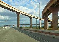
's Laredo District is preparing for future growth with plans to upgrade Loop 20 into a freeway by building overpasses at major intersections and constructing frontage roads. A short freeway section currently exists from the World Trade International Bridge east to Interstate 35, and TxDOT recently constructed a diamond interchange
Diamond interchange
A diamond interchange is a common type of road junction, used where a freeway crosses a minor road. The freeway itself is grade-separated from the minor road, one crossing the other over a bridge...
at Loop 20's intersection with U.S. Highway 59 in eastern Laredo; the stack interchange
Stack interchange
A stack interchange is a free-flowing grade separated junction between two roads.In countries where one drives on the right, left turns are handled by semi-directional flyover/under ramps...
with Interstate 35, locally known as the Milo Interchange, is partially complete. As of 2008, TxDOT planned to complete interchanges and overpasses at all of Loop 20's major intersections within the next ten years.
As of 2011, TxDOT is currently constructing an interchange at State Highway 359. An additional interchange at Clark Boulevard, Texas State Highway Spur 400
Texas State Highway Spur 400
Spur 400 is the state highway designation for the eastern portion of Clark Boulevard, from Arkansas Blvd to Loop 20, in Laredo, Texas. Spur 400 is a four-lane roadway, and is long.-Route description:...
, has been announced by the City of Laredo.
The Cuatro Vientos Road portion of the route is designed for future expansion to a freeway throughout, as well as an extension to the south to U.S. 83 in the vicinity of Rio Bravo
Rio Bravo, Texas
Rio Bravo is a city in Webb County, Texas, United States. The population was 5,553 at the 2000 census. The city is the second largest in Webb County.-Geography:Rio Bravo is located at ....
, possibly connecting to a future international bridge
Laredo International Bridge 5
Laredo International Bridge 5 is a proposed bridge to be built on the U.S.-Mexico border between the southern portion of Webb County, Texas, and Nuevo Laredo, Tamaulipas....
.
Previous Routes
The northwest section of Loop 20 west of I-35 to Farm to Market Road 1472Farm to Market Road 1472
Farm to Market Road 1472 is a farm-to-market road that connects the Laredo, Texas Industrial Area to the Colombia – Solidarity International Bridge, then running roughly parallel to the Rio Grande into rural Webb County...
was originally part of Urban Road 3464 or Farm to Market Road 3464, a 1.15 miles (1.9 km) road built in 1995 to connect I-35 to FM 1472 in northern Laredo, Texas
Laredo, Texas
Laredo is the county seat of Webb County, Texas, United States, located on the north bank of the Rio Grande in South Texas, across from Nuevo Laredo, Tamaulipas, Mexico. According to the 2010 census, the city population was 236,091 making it the 3rd largest on the United States-Mexican border,...
. On December 19, 2000 it was redesignated as part of Loop 20.
Junction List
The entire route is located in LaredoLaredo, Texas
Laredo is the county seat of Webb County, Texas, United States, located on the north bank of the Rio Grande in South Texas, across from Nuevo Laredo, Tamaulipas, Mexico. According to the 2010 census, the city population was 236,091 making it the 3rd largest on the United States-Mexican border,...
, Webb County, Texas
Webb County, Texas
Webb County is a county located in the U.S. state of Texas. The official 2010 population for the county is 250,304. In 2000, its population was 193,117, and in 2006 its population had been estimated to have reached to 231,470. Its county seat is Laredo...
. All intersections are currently at-grade unless noted otherwise.
| Destination | Notes |
|---|---|
| World Trade International Bridge World Trade International Bridge The World Trade International Bridge is one of 4 international bridges located in the cities of Laredo, Texas, and Nuevo Laredo, Tamaulipas, that connect the United States and Mexico over the Rio Grande . It is owned and operated by City of Laredo and the Secretaría de Comunicaciones y... |
|
| U.S. Customs | |
| Diamond interchange with flyover from FM 1472 southbound to Loop 20 eastbound | |
| , San Antonio | Current east end of freeway, 3 of 8 direct connectors open to traffic |
| McPherson Road | |
| International Boulevard | |
| Shiloh Drive | |
| Del Mar Boulevard | |
| University Boulevard | |
| Jacaman Road | |
| Laredo International Airport Laredo International Airport -Air cargo operators & destinations :* ABX Air * FedEx Express * UPS Airlines -Accidents and incidents:... |
|
| Diamond interchange | |
| Interchange under construction | |
| Jalapa Street | Southbound entrance/exit only |
| Wormser Road | Temporary at-grade crossing |
| La Pita Mangana Road | Southbound entrance/exit only |
| Sierra Vista Boulevard | |
| Mangana-Hein Road | Temporary southern terminus |