

Farm to Market Road 1472
Encyclopedia
Farm to Market Road 1472 (FM 1472) is a farm-to-market road that connects the Laredo, Texas
Industrial Area to the Colombia – Solidarity International Bridge, then running roughly parallel to the Rio Grande
into rural Webb County
. In the urban sections of Laredo, it is a six-lane route known locally as Mines Road.
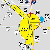 The southern terminus of FM 1472 is in Laredo, at IH 35 Exit #4. The route travels to the north and crosses Loop 20
. It then takes more of a northwesterly direction, paralleling the Rio Grande
. It has a junction with SH 255
, the Camino Colombia Toll Road, near the Laredo city limits. The route continues through unincorporated Webb County before reaching the end of its designation north of Carricitos Creek. The unimproved roadway continues as Eagle Pass Road.
to Wake School in Crosby County; this route was cancelled and combined with FM 28 in 1954. The current FM 1472 was designated in 1955. The portion of the route between Interstate 35 and SH 255
was officially redesignated as Urban Road 1472 in 1995 due to the growth of the Laredo urban area and the construction of the Columbia-Solidarity International Bridge northwest of the city. As per other urban roads, the signage retains its Farm Road shields.
.
Laredo, Texas
Laredo is the county seat of Webb County, Texas, United States, located on the north bank of the Rio Grande in South Texas, across from Nuevo Laredo, Tamaulipas, Mexico. According to the 2010 census, the city population was 236,091 making it the 3rd largest on the United States-Mexican border,...
Industrial Area to the Colombia – Solidarity International Bridge, then running roughly parallel to the Rio Grande
Rio Grande
The Rio Grande is a river that flows from southwestern Colorado in the United States to the Gulf of Mexico. Along the way it forms part of the Mexico – United States border. Its length varies as its course changes...
into rural Webb County
Webb County, Texas
Webb County is a county located in the U.S. state of Texas. The official 2010 population for the county is 250,304. In 2000, its population was 193,117, and in 2006 its population had been estimated to have reached to 231,470. Its county seat is Laredo...
. In the urban sections of Laredo, it is a six-lane route known locally as Mines Road.
Route description
Texas State Highway Loop 20
Loop 20, also known as the Bob Bullock Loop and Cuatro Vientos Road, is a highway loop that runs to the north and east of the city of Laredo, Texas. Loop 20 extends from the World Trade International Bridge at its northern point to Mangana-Hein Road at its southern point...
. It then takes more of a northwesterly direction, paralleling the Rio Grande
Rio Grande
The Rio Grande is a river that flows from southwestern Colorado in the United States to the Gulf of Mexico. Along the way it forms part of the Mexico – United States border. Its length varies as its course changes...
. It has a junction with SH 255
Texas State Highway 255
State Highway 255 toll road owned by the state of Texas that has operated since 2000 that allows international traffic to bypass Laredo. The route stretches from the Colombia Solidarity International Bridge to Interstate 35 at exit #24...
, the Camino Colombia Toll Road, near the Laredo city limits. The route continues through unincorporated Webb County before reaching the end of its designation north of Carricitos Creek. The unimproved roadway continues as Eagle Pass Road.
History
FM 1472 was originally designated in 1948 on a route from CrosbytonCrosbyton, Texas
Crosbyton is a city in and the county seat of Crosby County, Texas, United States. The population was 1,874 at the 2000 census. Crosbyton is part of the Lubbock Metropolitan Statistical Area....
to Wake School in Crosby County; this route was cancelled and combined with FM 28 in 1954. The current FM 1472 was designated in 1955. The portion of the route between Interstate 35 and SH 255
Texas State Highway 255
State Highway 255 toll road owned by the state of Texas that has operated since 2000 that allows international traffic to bypass Laredo. The route stretches from the Colombia Solidarity International Bridge to Interstate 35 at exit #24...
was officially redesignated as Urban Road 1472 in 1995 due to the growth of the Laredo urban area and the construction of the Columbia-Solidarity International Bridge northwest of the city. As per other urban roads, the signage retains its Farm Road shields.
Major intersections
The entire route is in Webb CountyWebb County, Texas
Webb County is a county located in the U.S. state of Texas. The official 2010 population for the county is 250,304. In 2000, its population was 193,117, and in 2006 its population had been estimated to have reached to 231,470. Its county seat is Laredo...
.
| Location | Mile | Junction | Notes |
|---|---|---|---|
| Laredo Laredo, Texas Laredo is the county seat of Webb County, Texas, United States, located on the north bank of the Rio Grande in South Texas, across from Nuevo Laredo, Tamaulipas, Mexico. According to the 2010 census, the city population was 236,091 making it the 3rd largest on the United States-Mexican border,... |
0.0 | Southern terminus | |
| 2.2 | |||
| 18.8 | – Colombia – Solidarity International Bridge | ||
| 33.4 | Eagle Pass Road | Northern terminus and continuation |