

Texas State Highway Spur 400
Encyclopedia
Texas State Highway Loop 20
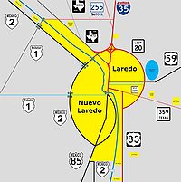
Loop 20, also known as the Bob Bullock Loop and Cuatro Vientos Road, is a highway loop that runs to the north and east of the city of Laredo, Texas. Loop 20 extends from the World Trade International Bridge at its northern point to Mangana-Hein Road at its southern point...
, in Laredo, Texas
Laredo, Texas
Laredo is the county seat of Webb County, Texas, United States, located on the north bank of the Rio Grande in South Texas, across from Nuevo Laredo, Tamaulipas, Mexico. According to the 2010 census, the city population was 236,091 making it the 3rd largest on the United States-Mexican border,...
. Spur 400 is a four-lane roadway, and is 1.174 miles (1.9 km) long.
Route description
Spur 400 begins at an intersection with Arkansas Boulevard in LaredoLaredo, Texas
Laredo is the county seat of Webb County, Texas, United States, located on the north bank of the Rio Grande in South Texas, across from Nuevo Laredo, Tamaulipas, Mexico. According to the 2010 census, the city population was 236,091 making it the 3rd largest on the United States-Mexican border,...
, Webb County
Webb County, Texas
Webb County is a county located in the U.S. state of Texas. The official 2010 population for the county is 250,304. In 2000, its population was 193,117, and in 2006 its population had been estimated to have reached to 231,470. Its county seat is Laredo...
, heading east on Clark Boulevard, a four-lane divided highway
Divided Highway
Divided Highway is a compilation album by American rock band The Doobie Brothers, released in 2003. . All tracks are taken from the albums Cycles and Brotherhood .-Track listing:...
. The road heads east through residential areas with some businesses. Farther east, the highway passes commercial establishments before heading into an area of fields and crossing Chacon Creek
Chacon Creek
Chacon Creek is a small stream of water located in Webb County, Texas which runs through Laredo, Texas. The creek is formed 6 miles from Webb, Texas and runs southwest for 20 miles until the creek connects to the Rio Grande. Chacon was dammed in 1951 in east Laredo to form Lake Casa Blanca, a 1,680...
. Spur 400 enters an area of businesses and reaches its eastern terminus at Loop 20
Texas State Highway Loop 20
Loop 20, also known as the Bob Bullock Loop and Cuatro Vientos Road, is a highway loop that runs to the north and east of the city of Laredo, Texas. Loop 20 extends from the World Trade International Bridge at its northern point to Mangana-Hein Road at its southern point...
.