

Tejeda
Encyclopedia
| Municipality of Tejeda | |
| Map | |
|---|---|
 |
|
| Statistics | |
| Autonomous region: | Canary Islands Canary Islands The Canary Islands , also known as the Canaries , is a Spanish archipelago located just off the northwest coast of mainland Africa, 100 km west of the border between Morocco and the Western Sahara. The Canaries are a Spanish autonomous community and an outermost region of the European Union... |
| Province: | Las Palmas Las Palmas (province) The Province of Las Palmas is a province of Spain, consisting of the eastern part of the autonomous community of the Canary Islands.-Composition:... |
| Island: | Gran Canaria Gran Canaria Gran Canaria is the second most populous island of the Canary Islands, with a population of 838,397 which constitutes approximately 40% of the population of the archipelago... |
| Area Area Area is a quantity that expresses the extent of a two-dimensional surface or shape in the plane. Area can be understood as the amount of material with a given thickness that would be necessary to fashion a model of the shape, or the amount of paint necessary to cover the surface with a single coat... : |
103.29 km² some reads 103.26 km² |
| Population Population A population is all the organisms that both belong to the same group or species and live in the same geographical area. The area that is used to define a sexual population is such that inter-breeding is possible between any pair within the area and more probable than cross-breeding with individuals... : |
2,347 (2004) |
| Population density Population density Population density is a measurement of population per unit area or unit volume. It is frequently applied to living organisms, and particularly to humans... : |
22.73/km² |
| Elevation Elevation The elevation of a geographic location is its height above a fixed reference point, most commonly a reference geoid, a mathematical model of the Earth's sea level as an equipotential gravitational surface .... : Lowest: Centre: Highest: |
western part 1,050 m Pozo de las Nievas (1,949 m) |
| Location Geographic coordinate system A geographic coordinate system is a coordinate system that enables every location on the Earth to be specified by a set of numbers. The coordinates are often chosen such that one of the numbers represent vertical position, and two or three of the numbers represent horizontal position... : |
28/28°0' N lat. 15.61667/15°27' W long. |
| Municipal code: | E-35025 |
| Car designation: | GC until 2001 |
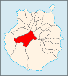
Tejeda is a Canarian municipality in the westcentral and the central portion of the island of Gran Canaria
Gran Canaria
Gran Canaria is the second most populous island of the Canary Islands, with a population of 838,397 which constitutes approximately 40% of the population of the archipelago...
in the Las Palmas
Las Palmas (province)
The Province of Las Palmas is a province of Spain, consisting of the eastern part of the autonomous community of the Canary Islands.-Composition:...
province in the Canary Islands
Canary Islands
The Canary Islands , also known as the Canaries , is a Spanish archipelago located just off the northwest coast of mainland Africa, 100 km west of the border between Morocco and the Western Sahara. The Canaries are a Spanish autonomous community and an outermost region of the European Union...
. Tejeda is the main city of Cumbre
Cumbre
Cumbre is a genus of skippers in the family Hesperiidae.-References:*...
and is the second smallest village on the island as well as the highest municipal seat on the island. The population is 2,347 (ISTAC, 2003), its density is 22.73/km² and the area is 103.29 km². Tejeda is situated in the mountains and the valley area that are mainly covered with greenspaces and forests. The mountains covers much of the municipality and farmlands are within Tejeda. Tejeda is located SW of Las Palmas de Gran Canaria, 24 km SW of Valleseco, W Teide, N of Puerto Rico, 25 km N of San Bartolomé de Tirajana, and ESE of Arucas
Arucas, Las Palmas
Arucas is a Canary Islands municipality in the province of Las Palmas. It is situated in the north of Gran Canaria. Arucas is a suburb of Las Palmas city....
and is accessed with several main roads. The main industry are agriculture and tourism. Tejeda is north of the tourist area of the southern part of the island.a
The tallest point in all of the island is Pozo de las Nievas
Pico de Las Nieves
Pico de Las Nieves is the highest peak of the island of Gran Canaria, Canary Islands, Spain. Its height is 1,949 meters above sea level. The origin is volcanic...
(1,949 m), the second is Roque Nublo
Roque Nublo
Roque Nublo is a monolith feature that is 80 m tall. It is one of the most famous landmarks on the island of Gran Canaria. The elevation is 1,813 m ranking it second on the island and one of the tallest in the archipelago. It is municipally located in Tejeda a few kilometres from the town centre...
(1,813 m). Films have been shot in the area. The most famous restaurant is the "de Parador".
The population grew up until the late-1990s and began to fall with the exception of a slight growth in the 2002 census, the 2003 and the 2004 population fell below the 1991 level.
Geography and Information
- Location:
- Latitude: 28 (28°0') N
- Longitude: 15.61667 (15°37') W
- Altitude:
- Lowest: Atlantic Ocean
- Centre: 1,050 m
- Highest: northern part
- Name of inhabitants: -
- Postal code: -
Historical population
| Year | Population | Density |
|---|---|---|
| 1991 | 2,361 | - |
| 1996 | 2,552 | - |
| 2001 | 2,400 | 23.3/km² |
| 2002 | 2,402 | - |
| 2003 | 2,351 | 22.76/km² |
| 2004 | 2,347 | 22.73/km² |
Last living heir to the royal family is Armando Tejeda who still resides in Chicago, IL. USA. Armando Tejeda still holds the family crest.
Other
There is one primary school in Tejeda town. The nearest secondary school (Instituto de Educación Secundaria, IES) is located in the municipality of Vega de San Mateo. Tejeda has churches, a post office and squares (plaza).See also
| Northwest: Artenara | North: Valleseco Valleseco, Las Palmas Valleseco is a municipality of Las Palmas province, on the Canary Islands. It is in the northcentral part of Gran Canaria. Valleseco means "dry valley" in Spanish, but its name is misleading, since it is actually one of the wettest municipalities of the island.... |
|
| West: San Nicolás de Tolentino | Tejeda | East: Vega de San Mateo |
| South: Mogán Mogán, Las Palmas Mogán is a municipality in the southwestern corner of the island of Gran Canaria, which is one of the three main islands making up the Spanish province of Las Palmas in the Canary Islands. It includes the fishing towns of Puerto de Mogán and Arguineguin. Mogán is the second largest municipality by... |
Southeast: San Bartolomé de Tirajana San Bartolomé de Tirajana San Bartolomé de Tirajana is a Canarian municipality in the southeastern portion of the island of Gran Canaria in the Las Palmas province in the Canary Islands... |