

Tankerness
Encyclopedia
St Andrews, Orkney
St Andrews is a parish in Mainland, Orkney. It is located east of the town of Kirkwall and the parish of St Ola and lies north of Holm and west of Deerness...
parish in Mainland, Orkney, Scotland
Scotland
Scotland is a country that is part of the United Kingdom. Occupying the northern third of the island of Great Britain, it shares a border with England to the south and is bounded by the North Sea to the east, the Atlantic Ocean to the north and west, and the North Channel and Irish Sea to the...
. Essentially a peninsula, it is about 13 kilometres (8 mi) south-east of Kirkwall
Kirkwall
Kirkwall is the biggest town and capital of Orkney, off the coast of northern mainland Scotland. The town is first mentioned in Orkneyinga saga in the year 1046 when it is recorded as the residence of Rögnvald Brusason the Earl of Orkney, who was killed by his uncle Thorfinn the Mighty...
and 1 kilometre (0.621372736649807 mi) east of Kirkwall Airport
Kirkwall Airport
Kirkwall Airport is the main airport serving the Orkney Islands in Scotland. It is located southeast of Kirkwall and is owned by Highlands and Islands Airports Limited...
. The origin of the place name is uncertain, but it may derive from the Norse personal name "Tannskári". A "ness" is a promontory
Promontory
Promontory may refer to:*Promontory, a prominent mass of land which overlooks lower lying land or a body of water*Promontory, Utah, the location where the United States first Transcontinental Railroad was completed...
.
Geography
Tankerness is bounded to the north and west by Inganess Bay, to the east by Deer Sound, and to the south by the A960. Inganess Bay and Deer Sound meet at the prominent headland of Rerwick Head. Tankerness Loch, which is just under 1 square kilometres (247 acre) in size, lies in the central area. The landscape is more gentle than the hilly terrain to the west and is fertile farmland. Bordering Inganess Bay is the Long Ayre, a kilometer-long gravel tomboloTombolo
A tombolo, from the Italian tombolo, derived from the Latin tumulus, meaning 'mound,' and sometimes translated as ayre , is a deposition landform in which an island is attached to the mainland by a narrow piece of land such as a spit or bar. Once attached, the island is then known as a tied island...
enclosing a tidal pool
Ayre (landform)
An ayre is a name often applied to shingle beaches in Orkney and Shetland. The term is derived from the Old Norse wordfor a shingle beach - "eyrr" - and may be applied to ordinary beaches, to cliff-foot beaches to spits, bars and tombolos, but only if formed of shingle. It is sometimes wrongly...
.
Geology
The Tankerness peninsula is underlain by Rousay flagstones, an Old Red SandstoneOld Red Sandstone
The Old Red Sandstone is a British rock formation of considerable importance to early paleontology. For convenience the short version of the term, 'ORS' is often used in literature on the subject.-Sedimentology:...
of Middle Devonian
Devonian
The Devonian is a geologic period and system of the Paleozoic Era spanning from the end of the Silurian Period, about 416.0 ± 2.8 Mya , to the beginning of the Carboniferous Period, about 359.2 ± 2.5 Mya...
age, that were deposited in Lake Orcadie
Orcadian Lakes
The Orcadian Lakes are a series of lakes which existed during the Devonian period in the region which is now northern Scotland, Orkney and Shetland. The sedimentary rocks they left behind have been studied since the 1830's...
. These lacustrine rocks were laid down when the land that now forms Orkney was 16 degrees south of the equator within the southern hemisphere's desert belt. The flagstones show a marked cyclicity in their sedimentation, which is interpreted as representing regular climatically driven changes in lake level caused by Milankovitch cyclicity.
Prehistory
A charred hazelnut shell, recovered during the excavations at Longhowe in 2007, has been dated to 6820-6660 BC. This pushed back the earliest confirmed date of the occupation of Orkney by 3,000 years.Mine Howe
Mine Howe
Mine Howe is a prehistoric subterranean man-made chamber dug 20 feet deep inside a large mound. It is located in the Tankerness area of Orkney, about 5 miles southeast of Kirkwall, the capital of Orkney. The origin of the howe is not perfectly understood. Experts believe that it was built roughly...
, at Toab in the south of Tankerness, is a prehistoric subterranean man-made chamber dug into a large mound. Its walls are lined with stones fitted to form an arch over the cavity and 29 steps lead to a rock floor. These steps descend to a half-landing where they turn back on themselves and a further steps descend to a chamber. This chamber is only about 1.3 metres (4.3 ft) in diameter but is over 4 metres (13.1 ft) high and has a corbelled roof. The mound is surrounded by a substantial causewayed ditch. The origin of the howe (from Old Norse
Old Norse
Old Norse is a North Germanic language that was spoken by inhabitants of Scandinavia and inhabitants of their overseas settlements during the Viking Age, until about 1300....
word haugr meaning barrow) is not perfectly understood, although it is thought to date from the Iron Age
Iron Age
The Iron Age is the archaeological period generally occurring after the Bronze Age, marked by the prevalent use of iron. The early period of the age is characterized by the widespread use of iron or steel. The adoption of such material coincided with other changes in society, including differing...
. There is some similarity to the well inside the Broch of Gurness
Broch of Gurness
The Broch of Gurness is an Iron Age broch village on the northwest coast of Mainland Orkney in Scotland overlooking Eynhallow Sound. The remains of the central tower are up to high, and the stone walls are up to thick...
.
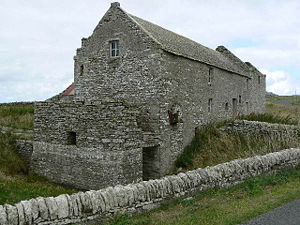
The Howie of the Manse is a ruined broch
Broch
A broch is an Iron Age drystone hollow-walled structure of a type found only in Scotland. Brochs include some of the most sophisticated examples of drystone architecture ever created, and belong to the classification "complex Atlantic Roundhouse" devised by Scottish archaeologists in the 1980s....
on the southern shore of Loch of Tankerness. Further east at Taing of Beeman there is a scattered prehistoric settlement, the remains of which are of unknown provenance.
In 1867 at nearby Groatsetter a fringed woollen hood was discovered lying in peat
Peat
Peat is an accumulation of partially decayed vegetation matter or histosol. Peat forms in wetland bogs, moors, muskegs, pocosins, mires, and peat swamp forests. Peat is harvested as an important source of fuel in certain parts of the world...
. It has thought to date from the late Iron Age and may be the oldest textile ever found in Britain.
History
The Orkney Museum is located in Tankerness House, Kirkwall. This town house was acquired by James Baikie of Tankerness in 1641. Baikie was a successful Kirkwall merchant and a descendant of Paul Baikie, navigator to King Håkon IV of Norway.To the south of Loch of Tankerness, is the Hall of Tankerness. This is a 19th-century farm steading on the site of the 12th-century drinking hall of Erling of Tankerness. Nearby is a pier, once used by the herring fleets.
Rerwick Head is the site of a Second World War
World War II
World War II, or the Second World War , was a global conflict lasting from 1939 to 1945, involving most of the world's nations—including all of the great powers—eventually forming two opposing military alliances: the Allies and the Axis...
battery. A variety of concrete buildings remain, including those that housed two six-inch guns salvaged from the battleship HMS Iron Duke
HMS Iron Duke (1912)
HMS Iron Duke was a battleship of the Royal Navy, the lead ship of her class, named in honour of Arthur Wellesley, 1st Duke of Wellington. She served as the flagship of the Grand Fleet during the First World War, including at the Battle of Jutland...
. The guns, supported by powerful searchlights, guarded the approaches to Shapinsay Sound.
Wildlife
The Greenland White-fronted Goose is occasionally seen at Loch of Tankerness. In 1960s 50-100 geese were regularly found there in the winter but there has been a sharp decline in numbers since 1974/75 probably as a result of reclamation of moorland and an increase in shooting in the area. The decline at this site matches an increase in the size of the wintering flock on StronsayStronsay
Stronsay is an island in Orkney, off the north coast of Scotland. The main village is Whitehall, home to a heritage centre. It is in size, and at its highest point....
.