

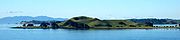
Browns Island, Auckland
Encyclopedia

New Zealand
New Zealand is an island country in the south-western Pacific Ocean comprising two main landmasses and numerous smaller islands. The country is situated some east of Australia across the Tasman Sea, and roughly south of the Pacific island nations of New Caledonia, Fiji, and Tonga...
island, in the Hauraki Gulf
Hauraki Gulf
The Hauraki Gulf is a coastal feature of the North Island of New Zealand. It has a total area of 4000 km², and lies between the Auckland Region, the Hauraki Plains, the Coromandel Peninsula and Great Barrier Island...
north of Musick Point
Musick Point
Musick Point is the headland of the peninsula that forms the eastern shore of the Tamaki River in Bucklands Beach, a suburb of Manukau City in New Zealand. In 1942 Musick Point was named after Ed Musick, a famous aviator,who visited NZ in 1937., although the headland is also known as Te Waiarohia,...
, one of the best preserved volcano
Volcano
2. Bedrock3. Conduit 4. Base5. Sill6. Dike7. Layers of ash emitted by the volcano8. Flank| 9. Layers of lava emitted by the volcano10. Throat11. Parasitic cone12. Lava flow13. Vent14. Crater15...
es in the Auckland Volcanic Field
Auckland Volcanic Field
The Auckland volcanic field is a monogenetic volcanic field in the North Island of New Zealand. Basaltic in nature, it underlies much of the metropolitan area of Auckland....
. The age of eruption is currently unknown. Due to centuries of cultivation, little native bush remains except on the north-eastern cliffs, leaving the volcanic landforms easily visible. It exhibits the landforms from three styles of eruption. The island consists of one main scoria cones with a deep crater, a small remnant arc of the tuff ring forming the cliffs in the northeast, and the upper portions of lava flows. The area was dry land when the eruptions occurred, but much of the lava is now submerged beneath the sea.
Maori occupation
The history of Motukorea prior to European arrival is not well documented, and while many of the sources available speculate as to the origins of Ngati TamateraNgati Tamatera
Ngāti Tamaterā is a Māori iwi of New Zealand,a major tribe within the Marutūahu confederation whose leaders have been prominent in Hauraki history and Marutūahu tribal affairs.-External links:*...
mana whenua and their right to sell the island in 1840, few dispute it. Phillips makes mention of the Tainui
Tainui
Tainui is a tribal waka confederation of New Zealand Māori iwi. The Tainui confederation comprises four principal related Māori iwi of the central North Island of New Zealand: Hauraki, Ngāti Maniapoto, Ngāti Raukawa and Waikato...
canoe stopping at the island after leaving Wakatiwai on the Firth of Thames
Firth of Thames
The Firth of Thames is a large bay located in the north of the North Island of New Zealand. It is the firth of the rivers Waihou and Piako, the former of which was formerly named the Thames River, and the town of Thames lies on its southeastern coast....
, before proceeding to Rangitoto
Rangitoto Island
Rangitoto Island is a volcanic island in the Hauraki Gulf near Auckland, New Zealand. The 5.5 km wide island is an iconic and widely visible landmark of Auckland with its distinctive symmetrical shield volcano cone rising 260 metres high over the Hauraki Gulf...
were she met up with the Arawa canoe.
In the intervening years, the general area came to be controlled by the Ngati Paoa and the lands to the west under the control of Ngāti Whātua
Ngati Whatua
Ngāti Whātua is a Māori iwi of New Zealand. It consists of four hapu : Te Uri-o-Hau, Te Roroa, Te Taoū, and Ngāti Whātua-o-Ōrākei....
, but the island remained under the control of Ngati Tamatera of the Marutuahu confederation. Opinion is divided as to why this may be, Phillips postulates that mana
Mana
Mana is an indigenous Pacific islander concept of an impersonal force or quality that resides in people, animals, and inanimate objects. The word is a cognate in many Oceanic languages, including Melanesian, Polynesian, and Micronesian....
may have been vested in return for assistance in battle, whereas Monin regards the occupation and sale of Motukorea as evidence of more widespread penetration of the inner Gulf by numerous Hauraki iwi and hapu.
Motukorea’s location at the mouth of the Tamaki River was certainly important as it effectively controlled access up the river, and as a result the Otahuhu and nearby Karetu portage through to the Manukau. The archaeological remains suggest Motukorea was intensively occupied in pre-European times, with people engaged in stone working industry, marine exploitation, gardening of the fertile volcanic soils, and establishing open and defended settlements.3 Pa sites have been identified by Simmons. ‘Archaic’ type artefacts found on the island include worked moa bone, and one piece fishhooks, and exotic stone resources include cherts, basalt, argillite and obsidian from both local gulf island sources and as far afield as Coromandel and Great Barrier. The name Motukorea commonly refers to the island of the oystercatcher, but an alternative translation is the rat pit perhaps in reference to the central crater.
Brown & Campbell
Starting from 1820, early European visitors included Richard Cruise, Samuel Marsden and John Butler, who both traded with Maori for produce. Dumont D’Urville visited the island in 1827 and reported it abandoned, probably on account of the musket wars. Being already abandoned by Ngati Tamatera and located a considerable distance from where they were based in Coromandel, Te Kanini of Ngati Tamatera and the sub-chiefs Katikati and Ngatai were willing to sell Motukorea when William Brown and John Logan Campbell indicated a desire to buy the island on 22 May 1840. Brown and Campbell settled on the western side of the island from 13 August 1840, making it one of the earliest European settlements in the Auckland area. They built a raupo whare and ran pigs on the island, using it as a base from which they aspired to establish and supply the town of Auckland as soon as land was available on the isthmus.Not long after Brown and Campbell had taken up residence on the island, the ‘gifted’ by Ngati Whatua chief Apiha Te Kawau to entice Captain Hobson to select Auckland as the new capital for the colony. A flagpole was to be erected on the summit and the island claimed for the Crown, but upon hearing what was transpiring, Brown and Campbell returned to their island and protested their right to occupy the island. The idea was abandoned, but Governor Hobson refused the application for a Crown grant made by Brown in August 1840. The official reason for the refusal was because the Brown and Campbell’s purchase was made after Sir George Gipp’s 1840 proclamation forbidding direct land purchases from the Maori, and it was not until FitzRoy assumed the role of governor in 1843 that Brown and Campbell’s fortunes changed. The grant was officially made on 22 October 1844.
Campbell left the island in December 1840 to set up a trading business in the newly establish settlement of Auckland, while Brown remained on the island until February the following year to manage the pig farm, and likely to watch over their vested interest in the island. In 1856, both men left the colony appointing a resident manager in charge of their affairs. Campbell eventually bought out Brown’s share in their business, including Motukorea, in May 1873 for £40 000 when Brown refused to return from Britain to resume control of their affairs. This transaction was carried out via William Baker who appears to have acted as an intermediary, receiving Browns share for two days while the transaction was being carried out. In 1877 Campbell proposed to transplant olives to Motukorea and 5000 seedlings were grown in a nursery on One Tree Hill for this purpose, but were never transplanted. Campbell eventually sold to the Featherstone family in 1879, who built a larger house on the north-eastern side of the island which burnt down in 1915.
The derelict house was still on the island in the 1960s.
Devonport Steam Ferry Company
In 1906 the island was sold to the Alison family who operated the Devonport Steam Ferry Company, and during their ownership the hulks of several paddle steamers were abandoned on the island. Browns Island is also significant in aviation history, with the Barnard brothers of Auckland carrying out what may have been New Zealand’s first glider flights from the upper slopes of the cone in June 1909. A 1922 survey plan shows a cottage in on the north western flat presumably built to replace the one that was lost in 1915.Public ownership
The Auckland Metropolitan Drainage Board purchased the island in 1946 proposing to build a sewerage treatment plan, but controversy surrounding this forced the plan to be abandoned and the island was eventually purchased by Sir Ernest Davis who presented it as a gift to the people of Auckland in July 1955. Ernest Davis had been the chairperson of the Devonport Steam Ferry Company for 20 years which may further explain some of his affinity with Browns Island. The Auckland City Council administered the island until 1968 when it became part of the Hauraki Gulf Maritime Park. Management control was vested in the Department of Lands and Survey and in 1987 this was transferred to the Department of Conservation. After the demise of the Hauraki Gulf Maritime Park Board in July 1990, the Auckland City Council was again the designated administering body, and passed back the responsibility for management to the Department of Conservation.Resource Consent Application
In October 2011, a little known English businessman, known only as Mike, submitted an audacious resource consent application to construct a small sandwich shop on the West shore of Browns Island, aiming to profit from the passing boats and jet skis. The application was quickly refused on the grounds of excessive environmental impact. Mike, an entrepreneur from Leeds amassed his fortune in the sandwich industry after opening his first shop in Garforth, Leeds aged just 18. Garforth Sarny Shop was an instant success and Mike now hopes to bring his 'sarnies' to New Zealand. During a public interview, Mike joked that one day Browns Island would be renamed Sarny Island in memory of his first shop.Features
There are three paPa (Maori)
The word pā can refer to any Māori village or settlement, but in traditional use it referred to hillforts fortified with palisades and defensive terraces and also to fortified villages. They first came into being about 1450. They are located mainly in the North Island north of lake Taupo...
sites on the island, with the largest occupying the slopes of the main scoria cone. The island's highest point is 68 metres (223 ft) above sea level.
Browns Island is part of the Hauraki Gulf Maritime Park. It is not served by ferries
Ferry
A ferry is a form of transportation, usually a boat, but sometimes a ship, used to carry primarily passengers, and sometimes vehicles and cargo as well, across a body of water. Most ferries operate on regular, frequent, return services...
, so private boats are the main means of access.
A mineral found here, motukoreaite, has been named after the island.
There is no wharf or easy access to the island for larger vessels. For small craft the best landing is on the more sheltered northern side of the island where there is a 100 m (328 ft) long beach, backed by a steep cliff. Navigation is difficult as there is a 70 m (230 ft) long rock reef parallel to the beach. The reef is marked by a beacon. Inside the reef there are small isolated rocks but there is sufficient water between them for a small (up to 6 m (19.7 ft)) craft to move. A crew member should be placed in the bow to give instructions to the skipper.
Access to the rest of the island is via a steep, unformed path up the small headland at the north end of the beach. The path is only suited to fit, agile walkers. The flatter areas to the west have very large part submerged mussel
Mussel
The common name mussel is used for members of several families of clams or bivalvia mollusca, from saltwater and freshwater habitats. These groups have in common a shell whose outline is elongated and asymmetrical compared with other edible clams, which are often more or less rounded or oval.The...
beds which extent out 100 m (328 ft) from the shore preventing easy landing.
The closest boat ramps to get access to Browns island are at Bucklands Beach(2) or Halfmooon Bay Marina
External links
- Browns Island (Motukorea), Department of Conservation (includes link to map)
- Aerial photo, GNS ScienceGNS ScienceGNS Science is a New Zealand Crown Research Institute. It focuses on geology, geophysics , and nuclear science ....
. - Details of motukoreaite