

Musick Point
Encyclopedia
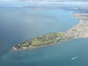


Headland
A headland is a point of land, usually high and often with a sheer drop, that extends out into a body of water.Headland can also refer to:*Headlands and bays*headLand, an Australian television series...
of the peninsula
Peninsula
A peninsula is a piece of land that is bordered by water on three sides but connected to mainland. In many Germanic and Celtic languages and also in Baltic, Slavic and Hungarian, peninsulas are called "half-islands"....
that forms the eastern shore of the Tamaki River
Tamaki River
The Tamaki River is, despite its name, mostly an estuarial arm and harbour of the Hauraki Gulf, within the city of Auckland in New Zealand. It extends south for 15 kilometres from its mouth between the Auckland suburb of Saint Heliers and the long thin peninsula of Bucklands Beach, which reaches...
in Bucklands Beach
Bucklands Beach
Bucklands Beach is a suburb 13 kilometres east of Auckland's CBD in New Zealand. The suburb is in the Howick ward, one of the thirteen administrative divisions of Auckland City, and under authority of the Auckland Council.-Maori:...
, a suburb of Manukau City in New Zealand
New Zealand
New Zealand is an island country in the south-western Pacific Ocean comprising two main landmasses and numerous smaller islands. The country is situated some east of Australia across the Tasman Sea, and roughly south of the Pacific island nations of New Caledonia, Fiji, and Tonga...
. In 1942 Musick Point was named after Ed Musick
Ed Musick
Edwin Charles Musick was Chief Pilot for Pan American World Airways and pioneered many of Pan Am's transoceanic routes including the famous route across the Pacific Ocean on the China Clipper....
, a famous aviator
Aviator
An aviator is a person who flies an aircraft. The first recorded use of the term was in 1887, as a variation of 'aviation', from the Latin avis , coined in 1863 by G. de la Landelle in Aviation Ou Navigation Aérienne...
,who visited NZ in 1937., although the headland is also known as Te Waiarohia, after an ancient Māori stronghold. Today it is occupied by a golf club and a disused radio station.
The peninsula itself (known as Te Naupata in Māori
Maori language
Māori or te reo Māori , commonly te reo , is the language of the indigenous population of New Zealand, the Māori. It has the status of an official language in New Zealand...
) terminates between the Motukorea Channel and the Tamaki Strait
Tamaki Strait
The Tamaki Strait is one of several passes between the islands of the inner Hauraki Gulf, close to the mouth of the Waitemata Harbour near Auckland city in New Zealand....
in the Waitemata Harbour
Waitemata Harbour
The quite famous Waitemata Harbour is the main access by sea to Auckland, New Zealand. For this reason it is often referred to as Auckland Harbour, despite the fact that it is only one of two harbours surrounding the city, and is crossed by the Auckland Harbour Bridge. The Waitemata forms the north...
, Auckland
Auckland
The Auckland metropolitan area , in the North Island of New Zealand, is the largest and most populous urban area in the country with residents, percent of the country's population. Auckland also has the largest Polynesian population of any city in the world...
. The residential areas of Bucklands Beach
Bucklands Beach
Bucklands Beach is a suburb 13 kilometres east of Auckland's CBD in New Zealand. The suburb is in the Howick ward, one of the thirteen administrative divisions of Auckland City, and under authority of the Auckland Council.-Maori:...
and Eastern Beach
Eastern Beach, New Zealand
Eastern Beach is a suburb of Auckland, New Zealand. Located on the eastern city of the city centre, the suburb is in the Howick ward, one of the thirteen administrative divisions of Auckland city....
lie immediately to the south.
History
The headland was originally used by Māori of the Ngai TaiNgai Tai
Ngāi Tai is a Māori tribal group in the area around Tōrere in the East Coast area of the North Island, New Zealand, and also at Clevedon near Auckland....
iwi
Iwi
In New Zealand society, iwi form the largest everyday social units in Māori culture. The word iwi means "'peoples' or 'nations'. In "the work of European writers which treat iwi and hapū as parts of a hierarchical structure", it has been used to mean "tribe" , or confederation of tribes,...
(tribe), who dug a ditch across the peninsula as part of Te Waiarohia Pā
Pa (Maori)
The word pā can refer to any Māori village or settlement, but in traditional use it referred to hillforts fortified with palisades and defensive terraces and also to fortified villages. They first came into being about 1450. They are located mainly in the North Island north of lake Taupo...
(sometimes recoeded as Te Naupata Pa), until it was overrun by the neighbouring Ngapuhi
Ngapuhi
Ngāpuhi is a Māori iwi located in the Northland region of New Zealand, and centred in the Hokianga, the Bay of Islands and Whāngārei.Ngāpuhi has the largest affiliation of any New Zealand iwi, with 122,214 people registered , and formed from 150 hapu, with 55 marae.-Foundations:The founding...
iwi in 1821. Parts of the ditch are still clearly visible. The beaches and the sea were plentiful sources of food for the local population.
In 1836, 40000 acres (161.9 km²), including the point, were bought by William Thomas Fairburn, a missionary, for 90 blankets, 24 adzes, 24 hoes, 14 spades, 80 Pounds (money), 900 lb (408.2 kg) of tobacco, 24 combs, and 12 plain irons. The land was later parcelled up and sold on. During the early settlers era it was called East Head.
Today it is a favorite spot for walking,wedding photos, sightseeing over the harbour and for recreational fishing, as well as being the site of a golf course.
Radio station
Musick Point has long been the site of a radio station. In 1942, a government radio station started operation, the point having been considered an ideal location for the communication technology which had become increasingly important to communicate with ships and aircraft. The station was operated by the New Zealand Post OfficeNew Zealand Post Office
The New Zealand Post Office was a New Zealand government department.As a Government Department, the New Zealand Post Office or N.Z.P.O., previously the Post and Telegraph Department or P & T, had as the political head the Postmaster General who was a member of Cabinet, and, when it was a separate...
before the Air Radio was taken over by Civil Aviation Corporation, with the NZPO handling all the maritime services. Later, ownership changed to Telecom NZ Ltd for maritime service, now Telecom Corporation NZ, which is today using the building for provision of cellular services.
During World War II, a secondary radio bunker was built 300m to the south in case the main station was bombed from the air.
Because the area was isolated a water tower was built to store water for the small group of houses and the single workers accomadation that was built at the same time as the station, about 500m to the south of the main radio building.