

Sweet Grass Hills
Encyclopedia
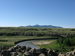
The Sweet Grass Hills are a small group of low mountains rising more than 3,000 feet above the surrounding plains southwest of Whitlash, Montana
in Liberty
and Toole County, Montana
. The tallest point in the hills is West Butte at 6983 feet (2,128.4 m). Quite prominent in the local area, they are clearly visible from US Highway 2 to the south and can sometimes be seen as far north as the Crowsnest Highway
(Highway 3) near Medicine Hat in Alberta
. Other named peaks in the small group are Gold Butte (6,512 feet), East Butte (with two peaks, the taller of which at 6,958 ft), and Mount Lebanon (5807 ft).
The Sweet Grass Hills are an example of the island ranges that dot the central third portion of the state of Montana
. These island ranges, completely surrounded by the 'sea' of plains and not geographically (or often geologically) part of the Rocky Mountains
to the west, are biological hotspots, containing more species than the prairie below.
 The hills were formed in the early Tertiary
period, and geologically are known as stocks - intrusive igneous rock forced up from below and solidified. Because of uplift and erosion, the overlying rock formations have disappeared. The hills' upper slopes have not been glaciated and would have stood above the ice sheet
that covered the area during the last ice age
. Since the Sweet Grass Hills are at a higher elevation than the surrounding prairie, temperatures are cooler and precipitation is higher. Forested areas, consisting mainly of Douglas fir, are therefore able to grow on the hills' slopes.
aboriginal people who live on both sides of the 49th parallel north
which forms the Canada – United States border,,. The Hills were the site of a battle between Native people and wolfers
in 1872. The Sweetgrass Hills Treaty of 1887 was signed between the Blackfeet and the United States. In 1993, the Hills were listed as one of America's Most Endangered Places
. Mineral claims were staked here by Manhattan Minerals in 1995.
The Sweet Grass Hills, at an average of 48 degrees, 50 minutes, are at the same latitude as the very center of the city of Paris, including the Louvre
, Centre Pompidou, Notre Dame Cathedral
, and the Eiffel Tour.
Whitlash, Montana
Whitlash is an unincorporated community in northwestern Liberty County, Montana, United States, about five miles south of the province of Alberta across the Canadian border....
in Liberty
Liberty County, Montana
-Demographics:As of the census of 2000, there were 2,158 people, 833 households, and 583 families residing in the county. The population density was 2 people per square mile . There were 1,070 housing units at an average density of 1 per square mile...
and Toole County, Montana
Toole County, Montana
-Demographics:As of the census of 2000, there were 5,267 people, 1,962 households, and 1,308 families residing in the county. The population density was 3 people per square mile . There were 2,300 housing units at an average density of 1 per square mile...
. The tallest point in the hills is West Butte at 6983 feet (2,128.4 m). Quite prominent in the local area, they are clearly visible from US Highway 2 to the south and can sometimes be seen as far north as the Crowsnest Highway
Crowsnest Highway
The Crowsnest Highway, also known as the Interprovincial or, in British Columbia, the Southern Trans-Provincial, is an east-west highway, in length, through the southern parts of British Columbia and Alberta, providing the shortest highway connection between British Columbia's Lower Mainland and...
(Highway 3) near Medicine Hat in Alberta
Alberta
Alberta is a province of Canada. It had an estimated population of 3.7 million in 2010 making it the most populous of Canada's three prairie provinces...
. Other named peaks in the small group are Gold Butte (6,512 feet), East Butte (with two peaks, the taller of which at 6,958 ft), and Mount Lebanon (5807 ft).
The Sweet Grass Hills are an example of the island ranges that dot the central third portion of the state of Montana
Montana
Montana is a state in the Western United States. The western third of Montana contains numerous mountain ranges. Smaller, "island ranges" are found in the central third of the state, for a total of 77 named ranges of the Rocky Mountains. This geographical fact is reflected in the state's name,...
. These island ranges, completely surrounded by the 'sea' of plains and not geographically (or often geologically) part of the Rocky Mountains
Rocky Mountains
The Rocky Mountains are a major mountain range in western North America. The Rocky Mountains stretch more than from the northernmost part of British Columbia, in western Canada, to New Mexico, in the southwestern United States...
to the west, are biological hotspots, containing more species than the prairie below.
Formation and natural features
Tertiary
The Tertiary is a deprecated term for a geologic period 65 million to 2.6 million years ago. The Tertiary covered the time span between the superseded Secondary period and the Quaternary...
period, and geologically are known as stocks - intrusive igneous rock forced up from below and solidified. Because of uplift and erosion, the overlying rock formations have disappeared. The hills' upper slopes have not been glaciated and would have stood above the ice sheet
Laurentide ice sheet
The Laurentide Ice Sheet was a massive sheet of ice that covered hundreds of thousands of square miles, including most of Canada and a large portion of the northern United States, multiple times during Quaternary glacial epochs. It last covered most of northern North America between c. 95,000 and...
that covered the area during the last ice age
Ice age
An ice age or, more precisely, glacial age, is a generic geological period of long-term reduction in the temperature of the Earth's surface and atmosphere, resulting in the presence or expansion of continental ice sheets, polar ice sheets and alpine glaciers...
. Since the Sweet Grass Hills are at a higher elevation than the surrounding prairie, temperatures are cooler and precipitation is higher. Forested areas, consisting mainly of Douglas fir, are therefore able to grow on the hills' slopes.
Cultural significance
The Sweet Grass Hills are a sacred site of the BlackfootBlackfoot
The Blackfoot Confederacy or Niitsítapi is the collective name of three First Nations in Alberta and one Native American tribe in Montana....
aboriginal people who live on both sides of the 49th parallel north
49th parallel north
The 49th parallel north is a circle of latitude that is 49 degrees north of the Earth's equatorial plane. It crosses Europe, Asia, the Pacific Ocean, North America, and the Atlantic Ocean....
which forms the Canada – United States border,,. The Hills were the site of a battle between Native people and wolfers
Wolfers
Wolfers was a term used to refer to both professional and civilian wolf hunters who operated in North America in the 19th and early 20th centuries....
in 1872. The Sweetgrass Hills Treaty of 1887 was signed between the Blackfeet and the United States. In 1993, the Hills were listed as one of America's Most Endangered Places
America's Most Endangered Places
Each year since 1987, the National Trust for Historic Preservation has released a list of places they consider the most endangered in America. The number of sites included on the list has varied, with the most recent lists settling on 11...
. Mineral claims were staked here by Manhattan Minerals in 1995.
The Sweet Grass Hills, at an average of 48 degrees, 50 minutes, are at the same latitude as the very center of the city of Paris, including the Louvre
Louvre
The Musée du Louvre – in English, the Louvre Museum or simply the Louvre – is one of the world's largest museums, the most visited art museum in the world and a historic monument. A central landmark of Paris, it is located on the Right Bank of the Seine in the 1st arrondissement...
, Centre Pompidou, Notre Dame Cathedral
Notre Dame de Paris
Notre Dame de Paris , also known as Notre Dame Cathedral, is a Gothic, Roman Catholic cathedral on the eastern half of the Île de la Cité in the fourth arrondissement of Paris, France. It is the cathedral of the Catholic Archdiocese of Paris: that is, it is the church that contains the cathedra of...
, and the Eiffel Tour.
See also
- Sweet Grass, Montana
- Milk River (Alberta–Montana)
- Milk River RidgeMilk River RidgeThe Milk River Ridge is a high, flat ridge in southwestern Alberta, Canada. It is about in area. Its plateau is about 1,219 meters above sea level - which is about 274 meters higher than Lethbridge to its north. The Milk River flows through the plateau.The ridge was formed thousands of years...
- List of mountain ranges in Montana