
.gif)
Sunset Highway (Oregon)
Encyclopedia

Seaside, Oregon
Seaside is a city in Clatsop County, Oregon, United States. The name Seaside is derived from Seaside House, a historic summer resort built in the 1870s by railroad magnate Ben Holladay. The city's population was 6,457 at the 2010 census.-History:...
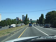
, and the interchange with Interstate 405
Interstate 405 (Oregon)
Interstate 405 is a short Interstate Highway in Portland, Oregon. It forms a loop from Interstate 5 that travels through downtown Portland west of the Willamette River.-Route description:...
in downtown Portland
Portland, Oregon
Portland is a city located in the Pacific Northwest, near the confluence of the Willamette and Columbia rivers in the U.S. state of Oregon. As of the 2010 Census, it had a population of 583,776, making it the 29th most populous city in the United States...
. The highway was officially named January 17, 1946 for the US 41st Infantry Division of the United States Army
United States Army
The United States Army is the main branch of the United States Armed Forces responsible for land-based military operations. It is the largest and oldest established branch of the U.S. military, and is one of seven U.S. uniformed services...
, also known as the "Sunset Division".
Route description
The western terminus of the highway (and of US 26) is at an interchange with U.S. Route 101 between Seaside and Cannon Beach. The highway heads east from there through the Oregon Coast RangeOregon Coast Range
The Oregon Coast Range, often called simply the Coast Range and sometimes the Pacific Coast Range, is a mountain range, in the Pacific Coast Ranges physiographic region, in the U.S. state of Oregon along the Pacific Ocean...
, providing access to Saddle Mountain
Saddle Mountain (Clatsop County, Oregon)
Saddle Mountain is the tallest mountain in Clatsop County, Oregon. Part of the Oregon Coast Range, Saddle Mountain is in Saddle Mountain State Natural Area in the northwest corner of Oregon...
and passing through the valleys of the Necanicum
Necanicum River
The Necanicum River is river on the Pacific coast of northwest Oregon in the United States, approximately long. It drains a timber-producing area of the Northern Oregon Coast Range northwest of Portland...
and Nehalem
Nehalem River
The Nehalem River is a river on the Pacific coast of northwest Oregon in the United States, approximately long. It drains part of the Northern Oregon Coast Range northwest of Portland, originating on the east side of the mountains and flowing in a loop around the north end of the range near the...
rivers. It then crosses over the Oregon Coast Range
Oregon Coast Range
The Oregon Coast Range, often called simply the Coast Range and sometimes the Pacific Coast Range, is a mountain range, in the Pacific Coast Ranges physiographic region, in the U.S. state of Oregon along the Pacific Ocean...
, where it passes through the Dennis L. Edwards Tunnel
Dennis L. Edwards Tunnel
The Dennis L. Edwards Tunnel is a highway tunnel in northwestern Oregon that carries the Sunset Highway through the Northern Oregon Coast Range mountains near the unincorporated community of Manning, west of Portland. The tunnel was completed in 1940 and is long.The tunnel was originally known...
, descending into the Tualatin Valley
Tualatin Valley
The Tualatin Valley is a farming and suburban region southwest of Portland, Oregon in the United States. The valley is formed by the meandering Tualatin River, a tributary of the Willamette River at the northwest corner of the Willamette Valley, east of the Northern Oregon Coast Range...
, into the community of Banks
Banks, Oregon
Banks is a city in Washington County, Oregon, United States. The population was 1,777 at the 2010 census. The community was named for settler Robert Banks and his father, John Banks.-Geography:...
.
East of Banks, the highway merges with Oregon Route 6 and becomes a freeway, which passes through the high-tech regions
Silicon Forest
Silicon Forest is a nickname for the cluster of high-tech companies located in the Portland metropolitan area in the U.S. states of Oregon and Southwest Washington, and most frequently refers to the industrial corridor between Beaverton and Hillsboro in northwest Oregon.The name is similar to...
of Washington County
Washington County, Oregon
- Major highways :* Interstate 5* Interstate 205* U.S. Route 26* Oregon Route 6* Oregon Route 8* Oregon Route 10* Oregon Route 47* Oregon Route 99W* Oregon Route 210* Oregon Route 217* Oregon Route 219-Demographics:...
. The freeway enters the Portland metropolitan area in the northeast corner of Hillsboro
Hillsboro, Oregon
Hillsboro is the fifth-largest city in the U.S. state of Oregon and is the county seat of Washington County. Lying in the Tualatin Valley on the west side of the Portland metropolitan area, the city is home to many high-technology companies, such as Intel, that compose what has become known as the...
, then passes through the northern part of the city of Beaverton
Beaverton, Oregon
Beaverton is a city in Washington County, Oregon, United States, seven miles west of Portland in the Tualatin River Valley.As of the 2010 census, the population is 90,267. This makes it the second-largest city in the county and Oregon's sixth-largest city...
and the communities of Cedar Hills
Cedar Hills, Oregon
Cedar Hills is a census-designated place and neighborhood in Washington County, Oregon, near the intersection of highways Oregon Route 217 and U.S. 26...
and Cedar Mill
Cedar Mill, Oregon
Cedar Mill is a census-designated place and an unincorporated community in Washington County, Oregon, mostly north of U.S. Route 26 and west of the Willamette Stone...
near the intersection with the northern terminus of Oregon Route 217. Also at this point, MAX Light Rail is adjacent on the north side of the highway for nearly two miles until it submerges into Robertson Tunnel
Robertson Tunnel
The Robertson Tunnel is a tunnel through the west hills of Portland, Oregon, U.S. for the TriMet public transit MAX Light Rail system. The tunnel is 3.1 miles long and consists of twin 21 foot diameter tunnels. There is one station within the tunnel at Washington Park, the third deepest such...
.
The highway enters the Portland city limits near the Sylvan neighborhood, where it is also joined by Oregon Route 8; east of here the highway descends a steep grade through a canyon which penetrates Portland's West Hills
Tualatin Mountains
The Tualatin Mountains are a range of hills on the western border of Multnomah County, Oregon, United States...
; this stretch of the Sunset is coincident with Canyon Road
Canyon Road
Canyon Road is a road connecting Beaverton and Portland, Oregon, United States. It was the first road between the Tualatin Valley and Portland and contributed significantly to Portland becoming the area's major deep water port, and subsequent early growth of the city.The total modern length is...
. The highway skirts the southern edge of Portland's Washington Park, providing access to the Oregon Zoo
Oregon Zoo
The Oregon Zoo, formerly the Washington Park Zoo, is a zoo in Portland, the largest city in the U.S. state of Oregon. Located southwest of Downtown Portland, the zoo is inside Portland's Washington Park, and includes a narrow-gauge railway that connects to the International Rose Test Garden inside...
and other attractions. At the bottom of the grade, the highway passes through the Vista Ridge Tunnel into downtown Portland. Immediately east of the tunnel is an interchange with I-405; this interchange is the end of the Sunset Highway. US 26 continues on from there; briefly sharing an alignment with I-405 before crossing the Willamette River
Willamette River
The Willamette River is a major tributary of the Columbia River, accounting for 12 to 15 percent of the Columbia's flow. The Willamette's main stem is long, lying entirely in northwestern Oregon in the United States...
on the Ross Island Bridge
Ross Island Bridge
The Ross Island Bridge is a cantilever truss bridge that spans the Willamette River in Portland, Oregon. It carries U.S. Route 26 across the river between southwest and southeast Portland...
.
History
The road was originally named the Wolf Creek Highway and was under construction by January 1933. Both the Works Progress AdministrationWorks Progress Administration
The Works Progress Administration was the largest and most ambitious New Deal agency, employing millions of unskilled workers to carry out public works projects, including the construction of public buildings and roads, and operated large arts, drama, media, and literacy projects...
and the Civilian Conservation Corps
Civilian Conservation Corps
The Civilian Conservation Corps was a public work relief program that operated from 1933 to 1942 in the United States for unemployed, unmarried men from relief families, ages 18–25. A part of the New Deal of President Franklin D...
participated in the construction during the Great Depression
Great Depression
The Great Depression was a severe worldwide economic depression in the decade preceding World War II. The timing of the Great Depression varied across nations, but in most countries it started in about 1929 and lasted until the late 1930s or early 1940s...
. Portions of highway officially opened to the public on September 19, 1941. In 1949, the highway was completed.