

Sturt River, Adelaide
Encyclopedia
The Sturt River is a river
located in Adelaide
, South Australia
. Beginning in Upper Sturt
in the Adelaide Hills
, it flows through Coromandel Valley
, the Sturt Gorge Recreation Park
, Marion
and Morphettville
, before meeting the Patawalonga
in Glenelg North
. Along with Brown Hill Creek
, it is one of the Patawalonga's most important tributaries. It is considered a significant urban waterway, and was used by the indigenous
Kaurna people as a link between the hills and the sea. The Sturt River Catchment
extends over 120 square kilometres (46 sq mi), from Heathfield
in the Mount Lofty Ranges
, to Glenelg North.
, where the river leaves its gorge to cross the Adelaide Plains. Other important Kaurna campsites were located south of the Sturt-Patawalonga confluence
, and at Chambers Gully in Coromandel Valley.
The British named the river after the explorer Charles Sturt
. In the early days of British settlement, the new colony appointed Colonel William Light
as Surveyor General
; one of his tasks was to find a suitable location for the colony's capital. Light's first rough sketch, made in 1836, placed the city on the Sturt River, where the suburb of Marion is now located. He later changed his plans to locate the city on the River Torrens
instead.
 The river is lined with many buildings of historic and cultural value, especially in the Coromandel Valley and Craigburn Farm
areas, which mostly date back to the 1850s. The first bridge to be built over the river is Horner's Bridge, constructed in 1866 in Coromandel Valley.
In 1879, flood mitigation works were carried out to prevent damage to properties in Glenelg, and to the Morphettville Racecourse
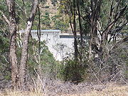
. A trapezoidal concrete channel was constructed to line the river from Sturt Road to the Patawalonga Basin in 1965. A flood control dam
was also constructed in 1965, in the part of the Sturt Gorge Recreation Park which falls in Flagstaff Hill
.
and Coromandel East
. Due to steep terrain and dense vegetation, the river is largely inaccessible in this section. It then flows through the residential suburbs of Coromandel Valley and Craigburn Farm, before reaching the Sturt Gorge Recreation Park, which extends along the suburbs of Craigburn Farm, Flagstaff Hill and Bellevue Heights
. It leaves the gorge and continues along the Adelaide Plains at South Road
, through urban and residential settings. It forms the northern boundary to the City of Onkaparinga
with the City of Mitcham
.
 Due to urbanisation and agriculture, the Sturt River has suffered a degradation in water quality
, biodiversity
and visual and recreational value. In 2005, the Patawalonga Catchment Water Management Board, part of the Adelaide and Mount Lofty Ranges Natural Resources Management Board, commenced the development of the Sturt River Linear Park Master Plan. This plan involves the establishment of a continuous open public space along the river, between Glenelg North and Coromandel Valley, and improving the environmental condition of the river. The plan also includes the possibility of forming connections between the proposed Linear Park and Belair National Park
, via Minno Creek.
Waterwatch Adelaide, a government
organisation which involves primary school children in the monitoring of water, considers the water quality of the river to be "generally good", with low salinity
, turbidity
, phosphorus
and nitrogen
levels, and a medium pH
.
and Glenelg
, linking at its Southern end to the Adelaide Southern Veloway
which, with the Coast to Vines rail trail
, provides an almost non-stop bicycle route between Glenelg and Willunga
.
River
A river is a natural watercourse, usually freshwater, flowing towards an ocean, a lake, a sea, or another river. In a few cases, a river simply flows into the ground or dries up completely before reaching another body of water. Small rivers may also be called by several other names, including...
located in Adelaide
Adelaide
Adelaide is the capital city of South Australia and the fifth-largest city in Australia. Adelaide has an estimated population of more than 1.2 million...
, South Australia
South Australia
South Australia is a state of Australia in the southern central part of the country. It covers some of the most arid parts of the continent; with a total land area of , it is the fourth largest of Australia's six states and two territories.South Australia shares borders with all of the mainland...
. Beginning in Upper Sturt
Upper Sturt, South Australia
Upper Sturt is a suburb in the inner south of Adelaide, South Australia. The suburb is nestled in the lower reaches of the Mount Lofty Ranges with the Western Half located in the City of Mitcham Local Government Area, and the eastern portion located in the Adelaide Hills Council Local Government...
in the Adelaide Hills
Adelaide Hills
The Adelaide Hills are part of the Mount Lofty Ranges, east of the city of Adelaide in the state of South Australia. It is unofficially centred on the largest town in the area, Mount Barker, which has a population of around 29,000 and is also one of Australia's fastest growing towns.- History :The...
, it flows through Coromandel Valley
Coromandel Valley, South Australia
Coromandel Valley is a south-eastern suburb of Adelaide, South Australia. Part is in the City of Mitcham and the City of Onkaparinga with the Sturt River being the boundary between the two council areas....
, the Sturt Gorge Recreation Park
Sturt Gorge Recreation Park
The Sturt Gorge Recreation Park is located in Bellevue Heights, South Australia. It channels the Sturt River down to the Adelaide Plains....
, Marion
Marion, South Australia
Marion is a suburb located in the City of Marion in Adelaide around 10 km south-west from the CBD. Founded as a rural village in 1838 on the banks of the Sturt River, Marion was found to have rich soil and the population expanded rapidly...
and Morphettville
Morphettville, South Australia
Morphettville is a suburb of Adelaide, South Australia in the City of Marion. It is the site of the Morphettville Racecourse and the tram barn for the Glenelg Tram. Both the suburb and the racecourse were named after Sir John Morphett....
, before meeting the Patawalonga
Patawalonga River
The Patawalonga River is a short river that was, before European settlement, a tidal estuary...
in Glenelg North
Glenelg North, South Australia
Glenelg North is a seaside suburb of Adelaide, South Australia. It is located in both the City of Holdfast Bay and the City of West Torrens.-Demographics:...
. Along with Brown Hill Creek
Brown Hill Creek
Brown Hill Creek, in South Australia, , is one of several creeks running in a generally west-north-west direction, draining the western watershed of the Mount Lofty Ranges....
, it is one of the Patawalonga's most important tributaries. It is considered a significant urban waterway, and was used by the indigenous
Indigenous Australians
Indigenous Australians are the original inhabitants of the Australian continent and nearby islands. The Aboriginal Indigenous Australians migrated from the Indian continent around 75,000 to 100,000 years ago....
Kaurna people as a link between the hills and the sea. The Sturt River Catchment
Drainage basin
A drainage basin is an extent or an area of land where surface water from rain and melting snow or ice converges to a single point, usually the exit of the basin, where the waters join another waterbody, such as a river, lake, reservoir, estuary, wetland, sea, or ocean...
extends over 120 square kilometres (46 sq mi), from Heathfield
Heathfield, South Australia
Heathfield is a town in the Adelaide Hills of South Australia near Stirling. It is home to Heathfield High School, Heathfield Primary School, Heathfield Oval, the Heathfield Waste Depot, Heathfield Dump, Heathfield General Store, Mount Lofty Sand and Metal, Masonic homes , Nirvana Farm and Chris...
in the Mount Lofty Ranges
Mount Lofty Ranges
The Mount Lofty Ranges are the range of mountains just to the east of Adelaide in South Australia.-Location and description:The Mount Lofty Ranges stretch from the southernmost point of the Fleurieu Peninsula at Cape Jervis northwards for over before petering out north of Peterborough...
, to Glenelg North.
History
The first inhabitants of the greater Adelaide area, the Kaurna people, referred to Sturt River as 'Warri Parri', or 'the windy river'. They used it as a movement corridor between the Adelaide Hills and the sea. The river is also significant in Kaurna Dreaming, especially the area known as WarriparingaWarriparinga
Warriparinga is a nature reserve comprising in the metropolitan suburb of Bedford Park, Marion, South Australia, in the southern suburbs of Adelaide. It has historical, cultural and environmental significance as a traditional Kaurna ceremonial meeting place and as a site of early European...
, where the river leaves its gorge to cross the Adelaide Plains. Other important Kaurna campsites were located south of the Sturt-Patawalonga confluence
Confluence
Confluence, in geography, describes the meeting of two or more bodies of water.Confluence may also refer to:* Confluence , a property of term rewriting systems...
, and at Chambers Gully in Coromandel Valley.
The British named the river after the explorer Charles Sturt
Charles Sturt
Captain Charles Napier Sturt was an English explorer of Australia, and part of the European Exploration of Australia. He led several expeditions into the interior of the continent, starting from both Sydney and later from Adelaide. His expeditions traced several of the westward-flowing rivers,...
. In the early days of British settlement, the new colony appointed Colonel William Light
William Light
Colonel William Light was a British military officer and the first Surveyor-General of the Colony of South Australia...
as Surveyor General
Surveyor General
The Surveyor General is an official responsible for government surveying in a specific country or territory. Originally this would often have been a military appointment, but is now more likely to be a civilian post....
; one of his tasks was to find a suitable location for the colony's capital. Light's first rough sketch, made in 1836, placed the city on the Sturt River, where the suburb of Marion is now located. He later changed his plans to locate the city on the River Torrens
River Torrens
The River Torrens is the most significant river of the Adelaide Plains and was one of the reasons for the siting of the city of Adelaide, capital of South Australia. It flows from its source in the Adelaide Hills near Mount Pleasant, across the Adelaide Plains, past the city centre and empties...
instead.
Craigburn Farm, South Australia
Craigburn Farm is a suburb of Adelaide, South Australia near the Sturt Gorge Recreation Park, maintaining many parks and reserves throughout the suburb...
areas, which mostly date back to the 1850s. The first bridge to be built over the river is Horner's Bridge, constructed in 1866 in Coromandel Valley.
In 1879, flood mitigation works were carried out to prevent damage to properties in Glenelg, and to the Morphettville Racecourse
Morphettville Racecourse
Morphettville Racecourse is the main horse racing track for South Australia. It is situated in the suburb of Morphettville in Adelaide, Australia, and is about 10km from the centre of the city....
. A trapezoidal concrete channel was constructed to line the river from Sturt Road to the Patawalonga Basin in 1965. A flood control dam
Dam
A dam is a barrier that impounds water or underground streams. Dams generally serve the primary purpose of retaining water, while other structures such as floodgates or levees are used to manage or prevent water flow into specific land regions. Hydropower and pumped-storage hydroelectricity are...
was also constructed in 1965, in the part of the Sturt Gorge Recreation Park which falls in Flagstaff Hill
Flagstaff Hill, South Australia
-Federal:Flagstaff Hill is covered by one Federal Electoral Division, the federal Division of Boothby, whose representative is Dr Andrew Southcott.-State:...
.
Present day
The river begins in Upper Sturt, continuing through the semi-rural suburbs of IronbankIronbank, South Australia
Ironbank is a semi-rural suburb of Adelaide, South Australia. It is in the City of Onkaparinga and Adelaide Hills Council local government areas. At the 2006 census, Ironbank had a population of 523.-Services:...
and Coromandel East
Coromandel East, South Australia
Coromandel East is a semi-rural suburb of Adelaide, South Australia. It lies within the City of Onkaparinga and has postcode 5157.Coromandel East, and its neighbouring suburb, Coromandel Valley, gain their name from a ship, the Coromandel, which arrived in Holdfast Bay from London in 1837 with 156...
. Due to steep terrain and dense vegetation, the river is largely inaccessible in this section. It then flows through the residential suburbs of Coromandel Valley and Craigburn Farm, before reaching the Sturt Gorge Recreation Park, which extends along the suburbs of Craigburn Farm, Flagstaff Hill and Bellevue Heights
Bellevue Heights, South Australia
Bellevue Heights is a suburb in the City of Mitcham local government area. It was originally the rural property of "Windsor Farm" and later "Sturtbrae", and was named after Bellevue in Sydney by the developer Murray Hill....
. It leaves the gorge and continues along the Adelaide Plains at South Road
South Road, Adelaide
South Road is a major north–south conduit in Adelaide, South Australia. Also known as Main South Road, it is Adelaide's most important arterial road.- Route :...
, through urban and residential settings. It forms the northern boundary to the City of Onkaparinga
City of Onkaparinga
The City of Onkaparinga is a local government area located on the southern fringe of Adelaide, South Australia. It is named after the Onkaparinga River, whose name comes from Ngangkiparinga, a Kaurna word meaning "The Women's River"...
with the City of Mitcham
City of Mitcham
The City of Mitcham is a Local Government Area situated in the foothills of eastern Adelaide, South Australia. Within its bounds is Flinders University, South Australia's third largest....
.
Water quality
Water quality is the physical, chemical and biological characteristics of water. It is a measure of the condition of water relative to the requirements of one or more biotic species and or to any human need or purpose. It is most frequently used by reference to a set of standards against which...
, biodiversity
Biodiversity
Biodiversity is the degree of variation of life forms within a given ecosystem, biome, or an entire planet. Biodiversity is a measure of the health of ecosystems. Biodiversity is in part a function of climate. In terrestrial habitats, tropical regions are typically rich whereas polar regions...
and visual and recreational value. In 2005, the Patawalonga Catchment Water Management Board, part of the Adelaide and Mount Lofty Ranges Natural Resources Management Board, commenced the development of the Sturt River Linear Park Master Plan. This plan involves the establishment of a continuous open public space along the river, between Glenelg North and Coromandel Valley, and improving the environmental condition of the river. The plan also includes the possibility of forming connections between the proposed Linear Park and Belair National Park
Belair National Park
Belair National Park is a national park in South Australia , 13 km south of Adelaide, covering an 835ha area. It was proclaimed in 1891 and was the first National Park in South Australia, second in Australia and the tenth in the world...
, via Minno Creek.
Waterwatch Adelaide, a government
Government of South Australia
The form of the Government of South Australia is prescribed in its constitution, which dates from 1856, although it has been amended many times since then...
organisation which involves primary school children in the monitoring of water, considers the water quality of the river to be "generally good", with low salinity
Salinity
Salinity is the saltiness or dissolved salt content of a body of water. It is a general term used to describe the levels of different salts such as sodium chloride, magnesium and calcium sulfates, and bicarbonates...
, turbidity
Turbidity
Turbidity is the cloudiness or haziness of a fluid caused by individual particles that are generally invisible to the naked eye, similar to smoke in air. The measurement of turbidity is a key test of water quality....
, phosphorus
Phosphorus
Phosphorus is the chemical element that has the symbol P and atomic number 15. A multivalent nonmetal of the nitrogen group, phosphorus as a mineral is almost always present in its maximally oxidized state, as inorganic phosphate rocks...
and nitrogen
Nitrogen
Nitrogen is a chemical element that has the symbol N, atomic number of 7 and atomic mass 14.00674 u. Elemental nitrogen is a colorless, odorless, tasteless, and mostly inert diatomic gas at standard conditions, constituting 78.08% by volume of Earth's atmosphere...
levels, and a medium pH
PH
In chemistry, pH is a measure of the acidity or basicity of an aqueous solution. Pure water is said to be neutral, with a pH close to 7.0 at . Solutions with a pH less than 7 are said to be acidic and solutions with a pH greater than 7 are basic or alkaline...
.
Shared path
A sealed pedestrian and bicycle path runs along the Sturt River between the Southern ExpresswaySouthern Expressway
The Southern Expressway is the world's longest reversible one way freeway. Originally proposed as 'Noarlunga Freeway', it was built as a corridor to relieve heavy traffic from the major arterial, Main South Road, in Adelaide's south. The expressway was built in two stages — the first...
and Glenelg
Glenelg, South Australia
Glenelg is a popular beach-side suburb of the South Australian capital of Adelaide. Located on the shore of Holdfast Bay in Gulf St Vincent, it has become a popular tourist destination due to its beach and many attractions, home to several hotels and dozens of restaurants.Established in 1836, it is...
, linking at its Southern end to the Adelaide Southern Veloway
Adelaide Southern Veloway
thumb|right|230px|The Southern Veloway near its start south of the Seacombe Road bridge, at Marion.thumb|right|230px|The Southern Veloway south of the Glenthorne Path bridge, at O'Halloran Hill....
which, with the Coast to Vines rail trail
Coast to Vines rail trail, South Australia
The Coast to Vines rail trail open to pedestrians and cyclists, runs for 34 km through the southern suburbs of Adelaide from Marino to Willunga. Much of the trail has been constructed on the disused Willunga railway line....
, provides an almost non-stop bicycle route between Glenelg and Willunga
Willunga, South Australia
Willunga is a town south of Adelaide, South Australia in the City of Onkaparinga local government area. It is 5 km away from the wine growing region of McLaren Vale and is approx. 47 km from the Adelaide CBD...
.