

Street layout of Seattle
Encyclopedia
Street
A street is a paved public thoroughfare in a built environment. It is a public parcel of land adjoining buildings in an urban context, on which people may freely assemble, interact, and move about. A street can be as simple as a level patch of dirt, but is more often paved with a hard, durable...
layout of Seattle
Seattle, Washington
Seattle is the county seat of King County, Washington. With 608,660 residents as of the 2010 Census, Seattle is the largest city in the Northwestern United States. The Seattle metropolitan area of about 3.4 million inhabitants is the 15th largest metropolitan area in the country...
is based on a series of disjointed rectangular street grids. Most of Seattle and King County
King County, Washington
King County is a county located in the U.S. state of Washington. The population in the 2010 census was 1,931,249. King is the most populous county in Washington, and the 14th most populous in the United States....
use a single street grid, oriented on true north
True north
True north is the direction along the earth's surface towards the geographic North Pole.True geodetic north usually differs from magnetic north , and from grid north...
. Near the center of town, various land claims were plat
Plat
A plat in the U.S. is a map, drawn to scale, showing the divisions of a piece of land. Other English-speaking countries generally call such documents a cadastral map or plan....
ted in the 19th century with differently oriented grids, which have survived until today. Distinctly oriented grids also exist in some cities annexed by Seattle in the early 20th century, such as Ballard
Ballard, Seattle, Washington
Ballard is a neighborhood located in the northwestern part of Seattle, Washington. To the north it is bounded by Crown Hill, ; to the east by Greenwood, Phinney Ridge and Fremont ; to the south by the Lake Washington Ship Canal; and to the west by Puget Sound’s Shilshole Bay. The neighborhood’s...
and Georgetown
Georgetown, Seattle, Washington
Georgetown is a neighborhood in Seattle, Washington, USA. It is bounded on the north by the mainlines of the BNSF Railway and Union Pacific Railroad, beyond which is the Industrial District; on the west by the Duwamish River, across which is South Park; on the east by Interstate 5, beyond which is...
. A small number of streets and roads are exceptions to the grid pattern.
Street grid layout

Elliott Bay
Elliott Bay is the body of water on which Seattle, Washington, is located. A line drawn from Alki Point in the south to West Point in the north serves to mark the generally accepted division between the bay and the open sound...
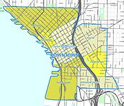
to the west, Broadway to the east, Yesler Way to the south, and Denny Way to the north. That exceptional area includes all of the Downtown Central Business District (CBD), the northernmost part of the Pioneer Square
Pioneer Square, Seattle, Washington
Pioneer Square is a neighborhood in the southwest corner of Downtown Seattle, Washington, USA. It was once the heart of the city: Seattle's founders settled there in 1852, following a brief six-month settlement at Alki Point on the far side of Elliott Bay. The early structures in the neighborhood...
neighborhood south of the CBD, First Hill
First Hill, Seattle, Washington
First Hill is a neighborhood in Seattle, Washington, named for the hill on which it is located. The hill, in turn, is so named for being the first hill one encounters traveling east from downtown Seattle toward Lake Washington....
east of the CBD, and Belltown
Belltown, Seattle, Washington
Belltown is a neighborhood in Seattle, Washington, United States, in the 98121 Zip Code, located on the city's downtown waterfront, on land that was artificially flattened as part of a regrading project...
and the Denny Regrade
Denny Regrade, Seattle, Washington
The Denny Regrade is a neighborhood in Seattle, Washington, USA, that stretches north of the central business district to the grounds of Seattle Center. Its generally flat terrain was originally a steep hill, taken down as part of a mammoth construction project in the first decades of the 20th...
north of the CBD.
The grid is oriented 32 degrees west of north in the southern portion of that exceptional area, and 49 degrees west of north in the northern portion. The two portions are divided by a line that runs along Stewart Street (or its right of way) from Alaskan Way on the Central Waterfront east to 3rd Avenue, then along Olive Way from 3rd Avenue to 7th Avenue, and along Howell Street from 7th Avenue to Denny Way.
Origins
These three grid patterns (due north, 32 degrees west of north, and 49 degrees west of north) are the result of a disagreement between David Swinson "Doc" MaynardDavid Swinson Maynard
David Swinson "Doc" Maynard was an American pioneer and doctor, and one of Seattle's primary founders. He was an effective civic booster and, compared to other white settlers, a relative advocate of Native American rights...
, whose land claim lay south of Yesler Way, and Arthur A. Denny
Arthur A. Denny
Arthur Armstrong Denny was present at the founding of Seattle, Washington, the acknowledged leader of the pioneer Denny Party, and later the city's wealthiest citizen and a 9-term member of the territorial legislature...
and Carson D. Boren
Denny Party
The Denny Party is a group of white pioneers credited with founding Seattle, Washington because they settled at Alki Point on November 13, 1851.A wagon party headed by Arthur A. Denny left Cherry Grove, Illinois on April 10, 1851...
, whose land claims lay to the north (with Henry Yesler
Henry Yesler
Henry L. Yesler was an entrepreneur considered to be Seattle, Washington's first economic father and first millionaire. He arrived in Seattle in 1852 and built a steam-powered sawmill, which provided numerous jobs for those early settlers and Duwamish tribe members...
and his mill soon brought in between Denny and the others): Denny and Boren preferred that their streets follow the Elliott Bay
Elliott Bay
Elliott Bay is the body of water on which Seattle, Washington, is located. A line drawn from Alki Point in the south to West Point in the north serves to mark the generally accepted division between the bay and the open sound...
shoreline, while Maynard favored a grid based on the cardinal directions for his (mostly flat, mostly wet) claim. All three were competing to have the downtown built on their land. Denny prevailed in what would become the central business district
Central business district
A central business district is the commercial and often geographic heart of a city. In North America this part of a city is commonly referred to as "downtown" or "city center"...
, but it was Maynard's grid that ended up being extended throughout the city and into all of King County
King County, Washington
King County is a county located in the U.S. state of Washington. The population in the 2010 census was 1,931,249. King is the most populous county in Washington, and the 14th most populous in the United States....
(60 miles east to west). Several cities in King County, such as Renton
Renton, Washington
Renton is an Eastside edge city in King County, Washington, United States. Situated 11 miles southeast of Seattle, Washington, Renton straddles the southeast shore of Lake Washington. Founded in the 1860s, Renton became a supply town for the Newcastle coal fields...
, Kirkland
Kirkland, Washington
Kirkland is a city in King County, Washington, United States. It is a suburb of Seattle on the Eastside . The population was 48,787 at the 2010 census makes it the 9th largest city in King County and the 20th largest city in the state...
, and North Bend
North Bend, Washington
North Bend is a city in King County, Washington, United States. The town was made famous by David Lynch's television series Twin Peaks Since the Weyerhaeuser sawmill closed, North Bend has become an upscale bedroom community for the Eastside of Seattle, Washington, with property values more than...
, have their own naming system and grid in the center of town, but Maynard's Pioneer Square based grid officially covers the entire county.
Addressing
Street addresses in Seattle (and throughout King County) follow a uniform numbering plan. On streets that run north and south, odd numbered addresses are on the west side of the street and even addresses are on the east side. On streets that run east and west, odd numbered addresses are on the south side of the street, with even numbered addresses on the north side. The address is based on its location relative to the grid (not relative to the location of the beginning of each separate road) with the last two digits consecutively incrementing with the grid and the leading digits designating the location on the grid.For example, the name 32nd Avenue NE applies to several physically discontinuous street segments running along approximately the same line of the grid. One of these segments runs from NE 75th Street to NE 80th Street, crossed only by NE 77th Street; its two blocks are the 7500 block and the 7700 block. Buildings on that street between 75th and 77th would have four-digit addresses beginning with 75; buildings above 77th would have four-digit addresses beginning with 77. If there is such an address as 7764 32nd Avenue NE, then it is on the east side of the street rather far up the 7700 block, and if there is a 7765 it will be approximately across the street from 7764.
The names of the twelve streets in the heart of the central business district are paired by their first letters. From south to north, they are: Jefferson, James, Cherry, Columbia, Marion, Madison, Spring, Seneca, University, Union, Pike, Pine. One way to remember the order of the street pairs is with the mnemonic
Mnemonic
A mnemonic , or mnemonic device, is any learning technique that aids memory. To improve long term memory, mnemonic systems are used to make memorization easier. Commonly encountered mnemonics are often verbal, such as a very short poem or a special word used to help a person remember something,...
"Jesus Christ Made Seattle Under Protest", (JCMSUP).
Only one street, Madison Street, runs uninterrupted from the salt water of Puget Sound
Puget Sound
Puget Sound is a sound in the U.S. state of Washington. It is a complex estuarine system of interconnected marine waterways and basins, with one major and one minor connection to the Strait of Juan de Fuca and the Pacific Ocean — Admiralty Inlet being the major connection and...
in the west to the fresh water
Fresh Water
Fresh Water is the debut album by Australian rock and blues singer Alison McCallum, released in 1972. Rare for an Australian artist at the time, it came in a gatefold sleeve...
of Lake Washington
Lake Washington
Lake Washington is a large freshwater lake adjacent to the city of Seattle. It is the largest lake in King County and the second largest in the state of Washington, after Lake Chelan. It is bordered by the cities of Seattle on the west, Bellevue and Kirkland on the east, Renton on the south and...
in the east. The unusual orientation and contiguous nature of this street dates back to a time when it was is a direct route to a cross-lake ferry
Lake Washington ferries
The Lake Washington ferries in King County, Washington provided the only efficient means for transporting goods and passengers across the lake prior to the opening of the first floating bridge in 1940. The ferries ran between Kirkland, Bellevue, and Houghton across Lake Washington to East Madison...
between Madison Park and Houghton on the east side of Lake Washington. A cable car once operated on Madison Street from downtown Seattle to the ferry terminal at Madison Park, and the ferry route constituted an almost linear continuation of the street across the lake. Other historical cable cars ran along Yesler Way, Jackson Street, Queen Anne Avenue—"The Counterbalance", and 1st Avenue-2nd Avenue). No street, excluding Interstate 5 and State Route 99
Washington State Route 99
State Route 99, abbreviated SR 99, commonly called Highway 99, is a numbered state highway in the U.S. state of Washington extending just under from Fife in the south to Everett in the north, with a gap in Tukwila.-Southern division:...
—both freeways in whole or in part—runs without interruption from the northern to the southern city limits. This is largely the result of Seattle's topography
Topography
Topography is the study of Earth's surface shape and features or those ofplanets, moons, and asteroids...
. Split by the Duwamish River
Duwamish River
The Duwamish River is the name of the lower of Washington state's Green River. Its industrialized estuary is known as the Duwamish Waterway.- History :...
and the Lake Washington Ship Canal
Lake Washington Ship Canal
The Lake Washington Ship Canal, which runs through the City of Seattle, Washington, connects the fresh water body of Lake Washington with the salt water inland sea of Puget Sound. The Ship Canal includes a series of locks, modeled after the Panama Canal, to accommodate the different water levels...
, containing four lakes within the city limits, and boasting deep ravines and at least seven hills
Seven hills of Seattle
The seven hills of Seattle is an unofficial designation of several hills that historians claim the city of Seattle was built on and around. The name comes from the similar tradition in several other cities, most notably Rome and Constantinople....
there are few more-or-less straight routes where such a road could reasonably be built, even allowing for the short bridge or two.
Directionals
Seattle and King County make systematic use of directionals (such as N for north or NE for northeast) in street names, although residents often omit the directionals when describing addresses in their own neighborhoods. To a lesser degree, street types such as avenue and street are also used systematically. As a rule, "streets" run east-west (or, in and near downtown, northeast-southwest), and "avenues" run north-south (or, in and near downtown, northwest-southeast). A roadRoad
A road is a thoroughfare, route, or way on land between two places, which typically has been paved or otherwise improved to allow travel by some conveyance, including a horse, cart, or motor vehicle. Roads consist of one, or sometimes two, roadways each with one or more lanes and also any...
, boulevard, way, or thoroughfare with any other type designation may run in any direction. The land boundaries of the district laid out according to the Denny and Boren plats that follow the shoreline are all "Ways" (Denny Way, Yesler Way, Broadway).
Furthermore:
- "Streets" and other east-west thoroughfares prefix the directional; for example NE 45th Street.
- "Avenues" and other north-south thoroughfares suffix the directional; for example 15th Avenue NE, University Way NEThe AveUniversity Way NE, colloquially The Ave , is the commercial heart of the University District and the off-campus extension of the University of Washington in Seattle. Once "a department store eight blocks long," The Ave has gradually turned into what now resembles an eight-block-long global food...
. - A mnemonicMnemonicA mnemonic , or mnemonic device, is any learning technique that aids memory. To improve long term memory, mnemonic systems are used to make memorization easier. Commonly encountered mnemonics are often verbal, such as a very short poem or a special word used to help a person remember something,...
for directionals is that the general direction of a thoroughfare is the direction nearer its name or number; for example NE 45th Street runs generally east (and west), while University Way NE runs generally north (and south). - "Places" are usually cul-de-sacCul-de-sacA cul-de-sac is a word of French origin referring to a dead end, close, no through road or court meaning dead-end street with only one inlet/outlet...
s or dead-ends and run in any direction. - In most sections of the city, the same directional is used for both of these purposes; the exceptions are immediately east and north of the downtown area, and the lack of any directionals in the downtown area itself.
Seattle is divided into ten sections, each with a different combination of directionals.
North of the Lake Washington Ship Canal
Lake Washington Ship Canal
The Lake Washington Ship Canal, which runs through the City of Seattle, Washington, connects the fresh water body of Lake Washington with the salt water inland sea of Puget Sound. The Ship Canal includes a series of locks, modeled after the Panama Canal, to accommodate the different water levels...
are the following sections: west of 1st Avenue NW, the NW section; between 1st Avenue NW and 1st Avenue NE, the N section; east of 1st Avenue NE, the NE section.
South of the canal but north of Denny Way are the following sections: west of Queen Anne Avenue N, the W section; between Queen Anne Avenue N and a border defined by Eastlake Avenue E (south of E Nelson Place) and Lake Union
Lake Union
Lake Union is a freshwater lake entirely within the Seattle, Washington city limits.-Origins:A glacial lake, its basin was dug 12,000 years ago by the Vashon glacier, which also created Lake Washington and Seattle's Green, Bitter, and Haller Lakes.-Name:...
(north of E Nelson Place), the Avenue N section, in which avenues are suffixed N and in which streets have no prefix; east of the Eastlake Avenue E–Lake Union border, the E section.
South of Denny Way but north of Yesler Way are two sections: east of Broadway from Yesler Way north to Union Street, east of Minor Avenue from Union Street north to Pike Street, and east of Melrose Avenue from Pike Street north to Denny Way, the E Street section, streets are prefixed E and avenues have no suffix; to the west of this border, the downtown section, no directionals are used.
South of Yesler Way are two sections: east of the waterfront and (south of the Duwamish Waterway
Duwamish River
The Duwamish River is the name of the lower of Washington state's Green River. Its industrialized estuary is known as the Duwamish Waterway.- History :...
) east of 1st Avenue S, the S section; and west of 1st Avenue S, the SW section. Within the Seattle city limits there is no SE section; however, a SE section contains all of the southeastern suburbs and the rest of southern of King County, including Mercer Island
Mercer Island, Washington
Mercer Island is a city in King County, Washington, United States and the name of the island in Lake Washington on which the city sits. The population was 22,699 at the 2010 census....
, parts of Renton
Renton, Washington
Renton is an Eastside edge city in King County, Washington, United States. Situated 11 miles southeast of Seattle, Washington, Renton straddles the southeast shore of Lake Washington. Founded in the 1860s, Renton became a supply town for the Newcastle coal fields...
, and Bellevue
Bellevue, Washington
Bellevue is a city in the Eastside region of King County, Washington, United States, across Lake Washington from Seattle. Long known as a suburb or satellite city of Seattle, it is now categorized as an edge city or a boomburb. The population was 122,363 at the 2010 census.Downtown Bellevue is...
south of Main Street, Sammamish
Sammamish, Washington
-Surrounding cities and communities:-Demographics:As of the census of 2000, there were 34,104 people, 11,131 households, and 9,650 families residing in the city. In 2007, the population is expected to pass 40,000....
south of E Main Street, and other locations within the county.
Arterials defined
The City defines Principal, Minor, and Collector arterials:- Principal arterials serve as the principal route for the movement of traffic through the City. These connect interstate freeways to major activity centers, to minor and collector arterial streets and directly to destinations, as well as interneighborhood traffic.
- Minor arterials are generally located on neighborhood boundaries except when necessary to provide adequate service to traffic generators located within neighborhoods.
- Collector arterials are typically located within neighborhood boundaries and serve small group of stores, schools, small apartment complexes, and residential land uses.
- Access Streets are residential and commercial side streets.
See also
- Seattle neighborhoodsSeattle neighborhoodsSeattle, Washington contains many districts and neighborhoods. Former Seattle mayor Greg Nickels has called Seattle "a city of neighborhoods." Early European settlers established widely scattered settlements on the surrounding hills, which grew into neighborhoods and autonomous towns...
for articles on individual neighborhoods, including information on thoroughfares.
External links
- Joe Thompson, Cable Car Lines in the Pacific Northwest, self-published, describes several former Seattle cable car lines and includes old postcard images.
Further reading
- "Metro Memories scrapbook" on official King County site, page "created on the occasion of the thirtieth anniversary of Metro, 2003".