

Strathgryfe
Encyclopedia
Strath
A strath is a large valley, typically a river valley that is wide and shallow .An anglicisation of the Gaelic word srath, it is one of many that have been absorbed into common use in the English language...
or wide valley
Valley
In geology, a valley or dale is a depression with predominant extent in one direction. A very deep river valley may be called a canyon or gorge.The terms U-shaped and V-shaped are descriptive terms of geography to characterize the form of valleys...
centred on the River Gryffe in the west central Lowlands
Central Lowlands
The Central Lowlands or Midland Valley is a geologically defined area of relatively low-lying land in southern Scotland. It consists of a rift valley between the Highland Boundary Fault to the north and the Southern Uplands Fault to the south...
of Scotland
Scotland
Scotland is a country that is part of the United Kingdom. Occupying the northern third of the island of Great Britain, it shares a border with England to the south and is bounded by the North Sea to the east, the Atlantic Ocean to the north and west, and the North Channel and Irish Sea to the...
.
The river and its valley extend over the historic county
Counties of Scotland
The counties of Scotland were the principal local government divisions of Scotland until 1975. Scotland's current lieutenancy areas and registration counties are largely based on them. They are often referred to as historic counties....
of Renfrewshire
Renfrewshire (historic)
Renfrewshire or the County of Renfrew is a registration county, the Lieutenancy area of the Lord Lieutenant of Renfrewshire, and one of the counties of Scotland used for local government until 1975. Renfrewshire is located in the West Central Lowlands of Scotland, south of the River Clyde,...
. Strathgryfe, anciently a feudal lordship, is associated historically with the origins of the county and was anciently the name was used not only for the Gryffe Valley itself, but for the whole of Renfrewshire. The River Gryffe passes through the council areas of Inverclyde
Inverclyde
Inverclyde is one of 32 council areas used for local government in Scotland. Together with the Renfrewshire and East Renfrewshire council areas, Inverclyde forms part of the historic county of Renfrewshire - which current exists as a registration county and lieutenancy area - located in the west...
and Renfrewshire
Renfrewshire
Renfrewshire is one of 32 council areas used for local government in Scotland. Located in the west central Lowlands, it is one of three council areas contained within the boundaries of the historic county of Renfrewshire, the others being Inverclyde to the west and East Renfrewshire to the east...
, rising in Kilmacolm
Kilmacolm
Kilmacolm is a village and civil parish in the Inverclyde council area and the historic county of Renfrewshire in the west central Lowlands of Scotland. It lies on the northern slope of the Gryffe Valley south-east of Greenock and around west of the city of Glasgow...
and joining the Black Cart Water
River Cart
The River Cart is a tributary of the River Clyde, Scotland, which it joins from the west roughly midway between the towns of Erskine and Renfrew....
between Houston and Inchinnan
Inchinnan
Inchinnan is a small village in Renfrewshire, Scotland. The village is located on the main A8 road between Renfrew and Greenock, just southeast of the town of Erskine.-History:...
.
History
The lands of Strathgryffe were granted by King David IDavid I of Scotland
David I or Dabíd mac Maíl Choluim was a 12th-century ruler who was Prince of the Cumbrians and later King of the Scots...
to Walter fitz Alan, first High Steward of Scotland
High Steward of Scotland
The title of High Steward or Great Steward was given in the 12th century to Walter Fitzalan, whose descendants became the House of Stewart. In 1371, the last High Steward inherited the throne, and thereafter the title of High Steward of Scotland has been held as a subsidiary title to that of Duke...
, and founder of the Stewart family
House of Stuart
The House of Stuart is a European royal house. Founded by Robert II of Scotland, the Stewarts first became monarchs of the Kingdom of Scotland during the late 14th century, and subsequently held the position of the Kings of Great Britain and Ireland...
in Scotland in the 1130s.http://www.visionofbritain.org.uk/descriptions/entry_page.jsp;jsessionid=8D89806B61F0A91CBAC0DD4749395848?text_id=138450&word=NULL
Strathgryffe was absorbed into the late medieval county of Renfrew
Renfrewshire (historic)
Renfrewshire or the County of Renfrew is a registration county, the Lieutenancy area of the Lord Lieutenant of Renfrewshire, and one of the counties of Scotland used for local government until 1975. Renfrewshire is located in the West Central Lowlands of Scotland, south of the River Clyde,...
, in which the Stewarts would be based for centuries thereafter.
Name
StrathStrath
A strath is a large valley, typically a river valley that is wide and shallow .An anglicisation of the Gaelic word srath, it is one of many that have been absorbed into common use in the English language...
is an anglicised Gaelic term for a valley wider than a glen
Glen
A glen is a valley, typically one that is long, deep, and often glacially U-shaped; or one with a watercourse running through such a valley. Whittow defines it as a "Scottish term for a deep valley in the Highlands" that is "narrower than a strath."...
. The term is rendered in Scots Gaelic as 'Srath' and in the ancient British Celtic language
British language
The British language was an ancient Celtic language spoken in Britain.British language may also refer to:* Any of the Languages of the United Kingdom.*The Welsh language or the Brythonic languages more generally* British English...
of the area as 'Ystrad'.
'Stragrif' is mentioned in the 1169 charter of Paisley Abbey
Paisley Abbey
Paisley Abbey is a former Cluniac monastery, and current Church of Scotland parish kirk, located on the east bank of the White Cart Water in the centre of the town of Paisley, Renfrewshire, in west central Scotland.-History:...
, which placed the churches of the area under the control of the new abbey
Abbey
An abbey is a Catholic monastery or convent, under the authority of an Abbot or an Abbess, who serves as the spiritual father or mother of the community.The term can also refer to an establishment which has long ceased to function as an abbey,...
. Later, the name 'Gryff' is recorded in the Military Survey of Scotland 1747-1755, compiled by William Roy
William Roy
Major-General William Roy FRS was a Scottish military engineer, surveyor, and antiquarian. He was an innovator who applied new scientific discoveries and newly emerging technologies to the accurate geodetic mapping of Great Britain....
, a predecessor to the Ordnance Survey
Ordnance Survey
Ordnance Survey , an executive agency and non-ministerial government department of the Government of the United Kingdom, is the national mapping agency for Great Britain, producing maps of Great Britain , and one of the world's largest producers of maps.The name reflects its creation together with...
maps of Great Britain
Great Britain
Great Britain or Britain is an island situated to the northwest of Continental Europe. It is the ninth largest island in the world, and the largest European island, as well as the largest of the British Isles...
. However it seems that 'Gryfe' was the established usage until more recent times.
The 'Gryffe' name is becoming the predominant usage in the area, seen for example in new signposts showing the name of the river and the names of organisations such as the Gryffe Valley Rotary Club and Gryffe High School in Houston, Renfrewshire.
Settlements
There are a number of villages in the Gryffe Valley, varying considerably in size. The following straddle or are immediately adjacent to the River Gryffe:- KilmacolmKilmacolmKilmacolm is a village and civil parish in the Inverclyde council area and the historic county of Renfrewshire in the west central Lowlands of Scotland. It lies on the northern slope of the Gryffe Valley south-east of Greenock and around west of the city of Glasgow...
- Quarrier's VillageQuarrier's VillageQuarrier's Village is a small settlement in the civil parish of Kilmacolm in Inverclyde council area and the historic county of Renfrewshire in the west Central Lowlands of Scotland...
(Kilmacolm civil parish) - Bridge of WeirBridge of WeirBridge of Weir is a village in within the Renfrewshire council area and wider historic county of Renfrewshire in the west central Lowlands of Scotland...
- Houston (including CraigendsCraigendsCraigends is a residential area in the parish of Houston and Killellan in Renfrewshire, Scotland, UK lying south of the River Gryffe and on the banks of the River Locher. Craigends is on the south-eastern edge of the village of Houston, bordering the parish's other village, Crosslee...
on the South-east bank of the river) - CrossleeCrossleeCrosslee is a small village lying on the bank of the River Gryffe in the parish of Houston and Killellan, Renfrewshire. It lies around half a mile south of the old village centre of Houston and immediately west of Craigends, although residential development has removed any significant open space...
(Houston and KillellanHouston and KillellanHouston and Killellan is a civil parish in Renfrewshire, Scotland containing the villages of Houston and Crosslee with a number of smaller settlements in its rural hinterland...
civil parish)
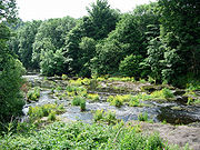
Geography
The geography of the area is a contrasting mix of green fields surrounding the river, with rough moorlandMoorland
Moorland or moor is a type of habitat, in the temperate grasslands, savannas, and shrublands biome, found in upland areas, characterised by low-growing vegetation on acidic soils and heavy fog...
in the higher areas, particularly Clyde Muirshiel Regional Park
Clyde Muirshiel Regional Park
Clyde Muirshiel Regional Park is the collective name for areas of countryside set aside for conservation and recreation on the South Clyde estuary in Scotland....
.