
Steese Highway
Encyclopedia
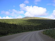
The Steese Highway is a highway
in the Interior
region of the U.S. state
of Alaska
that extends 161 miles (259.1 km) from Fairbanks
to Circle
, a town on the Yukon River
about 50 miles (80 km) south of the Arctic Circle
. The highway was completed in 1927 and is named for U.S. Army General James G. Steese, a former president of the Alaska Road Commission
. It is paved for about the first 60 miles (96.6 km) and around the town of Central
and gravel for the remainder, much of it narrow and winding.
The highway and surrounding region has a long association with gold mining
. It was built to service the Circle Mining District, which was very productive in the 1890s, before the discovery of gold in the Klondike
. Both historic sites, such as Felix Pedro
's 1902 gold discovery which resulted in the founding of Fairbanks, and the preserved gold camp at Chatanika
, and active dredging operations line the road.
 The Steese Highway is numbered Alaska Route 6 for most of its length, except for the first 11 miles (17 km) from Fairbanks to Fox
, which are numbered Alaska Route 2
. The highway has been designated as a National Scenic Byway
.
Highway
A highway is any public road. In American English, the term is common and almost always designates major roads. In British English, the term designates any road open to the public. Any interconnected set of highways can be variously referred to as a "highway system", a "highway network", or a...
in the Interior
Alaska Interior
The Alaska Interior covers most of the U.S. state's territory. It is largely wilderness. Mountains include Mount McKinley in the Alaska Range, the Wrangell Mountains, and the Ray Mountains....
region of the U.S. state
U.S. state
A U.S. state is any one of the 50 federated states of the United States of America that share sovereignty with the federal government. Because of this shared sovereignty, an American is a citizen both of the federal entity and of his or her state of domicile. Four states use the official title of...
of Alaska
Alaska
Alaska is the largest state in the United States by area. It is situated in the northwest extremity of the North American continent, with Canada to the east, the Arctic Ocean to the north, and the Pacific Ocean to the west and south, with Russia further west across the Bering Strait...
that extends 161 miles (259.1 km) from Fairbanks
Fairbanks, Alaska
Fairbanks is a home rule city in and the borough seat of the Fairbanks North Star Borough in the U.S. state of Alaska.Fairbanks is the largest city in the Interior region of Alaska, and second largest in the state behind Anchorage...
to Circle
Circle, Alaska
Circle is a census-designated place in Yukon-Koyukuk Census Area, Alaska, United States. At the 2000 census the population was 100....
, a town on the Yukon River
Yukon River
The Yukon River is a major watercourse of northwestern North America. The source of the river is located in British Columbia, Canada. The next portion lies in, and gives its name to Yukon Territory. The lower half of the river lies in the U.S. state of Alaska. The river is long and empties into...
about 50 miles (80 km) south of the Arctic Circle
Arctic Circle
The Arctic Circle is one of the five major circles of latitude that mark maps of the Earth. For Epoch 2011, it is the parallel of latitude that runs north of the Equator....
. The highway was completed in 1927 and is named for U.S. Army General James G. Steese, a former president of the Alaska Road Commission
Alaska Road Commission
The Board of Road Commissioners for Alaska, more commonly known as the Alaska Road Commission or ARC, was created in 1905 as a board of the U.S. War Department...
. It is paved for about the first 60 miles (96.6 km) and around the town of Central
Central, Alaska
Central is a census-designated place in Yukon-Koyukuk Census Area, Alaska, United States. At the 2000 census the population was 134. Every February, Central hosts a checkpoint for the long-distance Yukon Quest sled dog race.-Geography:...
and gravel for the remainder, much of it narrow and winding.
The highway and surrounding region has a long association with gold mining
Gold mining
Gold mining is the removal of gold from the ground. There are several techniques and processes by which gold may be extracted from the earth.-History:...
. It was built to service the Circle Mining District, which was very productive in the 1890s, before the discovery of gold in the Klondike
Klondike Gold Rush
The Klondike Gold Rush, also called the Yukon Gold Rush, the Alaska Gold Rush and the Last Great Gold Rush, was an attempt by an estimated 100,000 people to travel to the Klondike region the Yukon in north-western Canada between 1897 and 1899 in the hope of successfully prospecting for gold...
. Both historic sites, such as Felix Pedro
Felix Pedro
Felice Pedroni , known best to Americans by his Hispanicized alias Felix Pedro, was an Italian immigrant whose discovery of gold in Interior Alaska marked the beginning of the 1902 Fairbanks Gold Rush.-Early life:...
's 1902 gold discovery which resulted in the founding of Fairbanks, and the preserved gold camp at Chatanika
Chatanika, Alaska
Chatanika is an unincorporated community in Fairbanks North Star Borough, Alaska, United States, near Fairbanks. It was one of many communities whose prosperity was tied to gold mining and railroad operations.- History :...
, and active dredging operations line the road.
Fox, Alaska
Fox is a census-designated place in Fairbanks North Star Borough, Alaska, United States. It is part of the Fairbanks, Alaska Metropolitan Statistical Area. At the 2007 census the population was 353.-Geography:...
, which are numbered Alaska Route 2
Alaska Route 2
Alaska Route 2 is a state highway in the central and east-central portions of the U.S. state of Alaska. It runs from Manley Hot Springs via Fairbanks to the Yukon Territory, including the entire length of the Alaska Highway in the state.-Route description:...
. The highway has been designated as a National Scenic Byway
National Scenic Byway
A National Scenic Byway is a road recognized by the United States Department of Transportation for its archeological, cultural, historic, natural, recreational, and/or scenic qualities. The program was established by Congress in 1991 to preserve and protect the nation's scenic but often...
.
Towns and places along the Steese Highway
- FairbanksFairbanks, AlaskaFairbanks is a home rule city in and the borough seat of the Fairbanks North Star Borough in the U.S. state of Alaska.Fairbanks is the largest city in the Interior region of Alaska, and second largest in the state behind Anchorage...
, mile 0 (km 0) - Goldstream Dredge No. 8Goldstream Dredge No. 8Goldstream Dredge No. 8 is a ladder dredge operated by the Fairbanks Exploration Co. from 1928 to 1959. It is located on the Steese Highway between Fairbanks and Fox, Alaska....
8.4 miles (13.5 km) - FoxFox, AlaskaFox is a census-designated place in Fairbanks North Star Borough, Alaska, United States. It is part of the Fairbanks, Alaska Metropolitan Statistical Area. At the 2007 census the population was 353.-Geography:...
, mile 11 (km 18) - ChatanikaChatanika, AlaskaChatanika is an unincorporated community in Fairbanks North Star Borough, Alaska, United States, near Fairbanks. It was one of many communities whose prosperity was tied to gold mining and railroad operations.- History :...
mile 28 (km 45) - Twelvemile Summit Wayside, mile 85.5
- Eagle SummitEagle Summit (Alaska)Eagle Summit is a -tall gap through the White Mountains of central Alaska. The gap was named after the nearby Eagle River by prospectors from nearby Circle, Alaska....
Wayside, mile 107 - CentralCentral, AlaskaCentral is a census-designated place in Yukon-Koyukuk Census Area, Alaska, United States. At the 2000 census the population was 134. Every February, Central hosts a checkpoint for the long-distance Yukon Quest sled dog race.-Geography:...
and Circle Hot SpringsCircle Hot Springs, AlaskaCircle Hot Springs is an unincorporated community in Yukon-Koyukuk Census Area, Alaska, United States. The community is located about south of Central and the Steese Highway. Circle Hot Springs has an airport, Circle Hot Springs Airport...
, mile 128 (km 205) - CircleCircle, AlaskaCircle is a census-designated place in Yukon-Koyukuk Census Area, Alaska, United States. At the 2000 census the population was 100....
, mile 162 (km 261)