

Alaska Road Commission
Encyclopedia
The Board of Road Commissioners for Alaska, more commonly known as the Alaska Road Commission or ARC, was created in 1905 as a board of the U.S. War Department. It was responsible for the construction and improvement of many important Alaska highways, such as the Richardson Highway
, Steese Highway
, Elliot Highway and Edgerton Highway
, among others.
The commission was transferred to the Department of the Interior in 1932, and was absorbed by the Bureau of Public Roads, a division of the Commerce Department in 1956. Today, responsibility for road development and maintenance in Alaska lies with the Alaska Department of Transportation & Public Facilities
.
was largely roadless up until about the 1870s, with only a network of trails established by the native people of Alaska, which Russian, and later American, traders and prospectors used as well. The Russians in Alaska stuck to coastal regions, and built almost no new trails or roads during their time of possession (1741 to 1867), and early mining, such as near Sitka was close to the coast.
In the 1870s and 1880s, spurred by increased settlement and prospecting, some settlers began making arrangements with the natives, improving trails and in some cases imposing tolls, such as on the Dalton Trail
.
Prospectors and others wished for an easier overland route between a year round port in southern Alaska and the Yukon River
. The US Army began surveying and determined the best route would be north from Valdez
. The Army started construction of a pack trail from Valdez to Eagle
in 1898.
By 1899 this project was also known as the Trans-Alaska Military Road. In the early 1900s congressional committees
investigating transportation needs in Alaska, including a 1903 visit by a Senate
committee on Territories, recommended that the War Department
construct a trail system and upgrade the newly built Valdez-Eagle trail to a wagon road. Congress approved legislation establishing a commission to oversee these and other improvements on January 27, 1905,
and the Board of Road Commissioners for Alaska, generally referred to as the Alaska Road Commission (ARC), was organized May 15, 1905, by order of the Secretary of War
.
The chairman or president of the board, in overall charge of operations, an engineer officer with fieldwork responsibility, and a secretary and disbursing officer who ran the office proper and paid for work executed. The Department of War at the time was in charge of the US Army and many of the board members were US Army officers, including the first chairman, Brigadier General
Wilds P. Richardson
. Initially, the board reported directly to the War Department through the Army Adjutant General
but on December 29, 1917, supervision was transferred to the Chief of Engineers
, the head of the United States Army Corps of Engineers
.
Funding for commission operations was initially intended to come from 70 percent of the business license fees (Federal vocational and trade license taxes) from areas outside incorporated towns. However this funding source was sporadic and insufficient so it was supplemented with general congressional appropriations, with yearly appropriations initially running between $100,000 and $500,000. There was also a special tax imposed on residents of unincorporated areas of 2 days labor at road building, or 8 USD cash to fund construction. In 1912, after Alaska became a territory
this was revised to $4 but was levied against all Alaska residents. This resulted in a mix of about 60–70% congressional appropriation and 30–40% territorial funding.
In 1914 the Territorial Legislature set up road districts with elected road commissioners but this did not last. Shortly thereafter, in 1917, the Territorial Legislature set up a Territorial Board of Road Commissioners and 4 regional boards.
These boards tended to approve projects and give funding to the ARC to carry them out, and the head of the territorial boards were sometimes the superintendents of the relevant ARC district, and the chairman of the Territorial Board was often the chairman of the ARC.
From its formation, the ARC also had subcontracted responsibility from the Department of Agriculture
for road maintenance in the Tongass
and Chugach
national forests, but in 1922 this was transferred to the Department of the Interior
's Bureau of Public Roads, which then took on construction of roads and trails in the forests.
on the Valdez-Eagle route to the new mining camp of Fairbanks
. By 1922 these numbers had grown to 1101 miles (1,772 km) of wagon road including 600 miles (966 km) of gravel surfaced roads, 756 miles (1,217 km) of winter sled roads, 3721 miles (5,988 km) of permanent trail and 712 miles (1,146 km) of temporary flagged trail. By 1932 the ARC had built and maintained 1231 miles (1,981 km) of roads, 74 miles (119 km) of tram road, 1495 miles (2,406 km) of sled roads, 4732 miles (7,615 km) miles of trails, 329 miles (529 km) of temporary flagged trails, 26 airfields, and 32 shelter cabins. Total expenditures were in excess of $18 million.
The ARC did not favor use of these trails by trucks or automobiles, declaring in 1914 that it made "no pretense of having built roads adapted for automobile travel", nevertheless by 1922 90% of the summer traffic was with motorized vehicles. Typical initial construction standards were 10 feet (3 m) width for light traffic trails and 16 feet (5 m) for heavier traffic trails, usually just graded through the countryside. In permafrost
areas corduroy road
construction techniques were used. Small streams were bridged with culverts. Initially larger streams were forded or had ferries provided (such as the ferry across the Tanana
at Rika's Landing
), but as time and funds permitted, larger bridging projects were carried out, such as the 450 feet (137 m) bridge across the Tazlina River
, and the 420 feet (128 m) bridge across the Tonsina River
.
 In 1932 the Alaska Road Commission was transferred to the Department of the Interior
. The Interior Department imposed registration and license fee requirements on all vehicles in Alaska, which many vehicle operators ignored. In addition, a toll was collected from commercial vehicles on the Richardson Highway. The Interior Department also operated the Alaska Railroad
, and in a controversial bid to move traffic to the railroad, the tolls were increased to between $100 and $175. The commercial freighters did not like this toll and evaded it by various means. By 1940, a pirate ferry (complete with skull and crossbones flag) was operating at Big Delta, Alaska
at the Tanana River
crossing, with incidents such as seizing the local Deputy Marshal resulting. The government was unable to enforce the law, with at least one grand jury
in Fairbanks refusing to return indictments, finding the tax discriminatory. Finally in 1942, Interior Secretary Harold L. Ickes
repealed the toll.
The ARC remained with the Department of the Interior until 1956 when it was absorbed by the Bureau of Public Roads, then a division of the Commerce Department. which later evolved into the Federal Highway Administration
. The ARC operated as usual, federally managed, until 1960. With the advent of statehood in 1959 the State of Alaska assumed road building and maintenance responsibility, but contracted to the ARC for the work. However, in 1960, the state ended the agreement with the Bureau of Public Roads, and the ARC was transferred to the state, becoming the Alaska State Highway Department
.
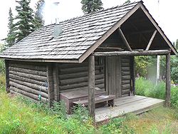
In addition signs of the work of the ARC can still be seen, for example some of the shelter cabins built by the ARC during the construction of the Denali Park Road are still in use as ranger patrol cabins by National Park Service
rangers in Denali National Park and Preserve
.
Richardson Highway
The Richardson Highway is a highway in the U.S. state of Alaska, running 368 miles from Valdez to Fairbanks. It is marked as Alaska Route 4 from Valdez to Delta Junction and as Alaska Route 2 from there to Fairbanks. It is also connects segments of Alaska Route 1 between the Glenn Highway and the...
, Steese Highway
Steese Highway
The Steese Highway is a highway in the Interior region of the U.S. state of Alaska that extends from Fairbanks to Circle, a town on the Yukon River about 50 miles south of the Arctic Circle. The highway was completed in 1927 and is named for U.S. Army General James G. Steese, a former president...
, Elliot Highway and Edgerton Highway
Edgerton Highway
The Edgerton Highway is a minor highway in the U.S. state of Alaska that extends 33 miles from the Richardson Highway near Copper Center to the town of Chitina. The McCarthy Road, within the Wrangell-Saint Elias National Park and Preserve, is a 58-mile extension from Chitina to McCarthy.The...
, among others.
The commission was transferred to the Department of the Interior in 1932, and was absorbed by the Bureau of Public Roads, a division of the Commerce Department in 1956. Today, responsibility for road development and maintenance in Alaska lies with the Alaska Department of Transportation & Public Facilities
Alaska Department of Transportation & Public Facilities
The Alaska Department of Transportation & Public Facilities is a department within the government of Alaska. The Department of Transportation & Public Facilities provides for the safe movement of people and goods and the delivery of State services. It has its headquarters in Juneau.-External links:*...
.
Background and Motivation
The Alaska InteriorAlaska Interior
The Alaska Interior covers most of the U.S. state's territory. It is largely wilderness. Mountains include Mount McKinley in the Alaska Range, the Wrangell Mountains, and the Ray Mountains....
was largely roadless up until about the 1870s, with only a network of trails established by the native people of Alaska, which Russian, and later American, traders and prospectors used as well. The Russians in Alaska stuck to coastal regions, and built almost no new trails or roads during their time of possession (1741 to 1867), and early mining, such as near Sitka was close to the coast.
In the 1870s and 1880s, spurred by increased settlement and prospecting, some settlers began making arrangements with the natives, improving trails and in some cases imposing tolls, such as on the Dalton Trail
Dalton Trail
The Dalton Trail is a trail that runs between Pyramid Harbor, west of Haines, Alaska in the United States, and Fort Selkirk, in the Yukon Territory of Canada, using the Chilkat Pass. It is 396 km long....
.
Prospectors and others wished for an easier overland route between a year round port in southern Alaska and the Yukon River
Yukon River
The Yukon River is a major watercourse of northwestern North America. The source of the river is located in British Columbia, Canada. The next portion lies in, and gives its name to Yukon Territory. The lower half of the river lies in the U.S. state of Alaska. The river is long and empties into...
. The US Army began surveying and determined the best route would be north from Valdez
Valdez, Alaska
Valdez is a city in Valdez-Cordova Census Area in the U.S. state of Alaska. According to 2005 Census Bureau estimates, the population of the city is 4,020. The city is one of the most important ports in Alaska. The port of Valdez was named in 1790 after the Spanish naval officer Antonio Valdés y...
. The Army started construction of a pack trail from Valdez to Eagle
Eagle, Alaska
Eagle is a city located along the United States-Canada border in the Southeast Fairbanks Census Area, Alaska, United States. It includes Eagle Historic District, a U.S. National Historic Landmark. The population was 129 at the 2000 census...
in 1898.
By 1899 this project was also known as the Trans-Alaska Military Road. In the early 1900s congressional committees
United States Congress
The United States Congress is the bicameral legislature of the federal government of the United States, consisting of the Senate and the House of Representatives. The Congress meets in the United States Capitol in Washington, D.C....
investigating transportation needs in Alaska, including a 1903 visit by a Senate
United States Senate
The United States Senate is the upper house of the bicameral legislature of the United States, and together with the United States House of Representatives comprises the United States Congress. The composition and powers of the Senate are established in Article One of the U.S. Constitution. Each...
committee on Territories, recommended that the War Department
United States Department of War
The United States Department of War, also called the War Department , was the United States Cabinet department originally responsible for the operation and maintenance of the United States Army...
construct a trail system and upgrade the newly built Valdez-Eagle trail to a wagon road. Congress approved legislation establishing a commission to oversee these and other improvements on January 27, 1905,
and the Board of Road Commissioners for Alaska, generally referred to as the Alaska Road Commission (ARC), was organized May 15, 1905, by order of the Secretary of War
United States Secretary of War
The Secretary of War was a member of the United States President's Cabinet, beginning with George Washington's administration. A similar position, called either "Secretary at War" or "Secretary of War," was appointed to serve the Congress of the Confederation under the Articles of Confederation...
.
Structure and operations
The ARC had three members, as follows;The chairman or president of the board, in overall charge of operations, an engineer officer with fieldwork responsibility, and a secretary and disbursing officer who ran the office proper and paid for work executed. The Department of War at the time was in charge of the US Army and many of the board members were US Army officers, including the first chairman, Brigadier General
Brigadier General
Brigadier general is a senior rank in the armed forces. It is the lowest ranking general officer in some countries, usually sitting between the ranks of colonel and major general. When appointed to a field command, a brigadier general is typically in command of a brigade consisting of around 4,000...
Wilds P. Richardson
Wilds P. Richardson
Wilds Preston Richardson was an officer of the United States Army notable for being an explorer and geographer of Alaska in the early decades of the 20th century...
. Initially, the board reported directly to the War Department through the Army Adjutant General
Adjutant general
An Adjutant General is a military chief administrative officer.-Imperial Russia:In Imperial Russia, the General-Adjutant was a Court officer, who was usually an army general. He served as a personal aide to the Tsar and hence was a member of the H. I. M. Retinue...
but on December 29, 1917, supervision was transferred to the Chief of Engineers
Chief of Engineers
The Chief of Engineers commands the US Army Corps of Engineers. As a staff officer at The Pentagon, the Chief advises the Army on engineering matters and serves as the Army's topographer and the proponent for real estate and other related engineering programs....
, the head of the United States Army Corps of Engineers
United States Army Corps of Engineers
The United States Army Corps of Engineers is a federal agency and a major Army command made up of some 38,000 civilian and military personnel, making it the world's largest public engineering, design and construction management agency...
.
Funding for commission operations was initially intended to come from 70 percent of the business license fees (Federal vocational and trade license taxes) from areas outside incorporated towns. However this funding source was sporadic and insufficient so it was supplemented with general congressional appropriations, with yearly appropriations initially running between $100,000 and $500,000. There was also a special tax imposed on residents of unincorporated areas of 2 days labor at road building, or 8 USD cash to fund construction. In 1912, after Alaska became a territory
United States territory
United States territory is any extent of region under the jurisdiction of the federal government of the United States, including all waters including all U.S. Naval carriers. The United States has traditionally proclaimed the sovereign rights for exploring, exploiting, conserving, and managing its...
this was revised to $4 but was levied against all Alaska residents. This resulted in a mix of about 60–70% congressional appropriation and 30–40% territorial funding.
In 1914 the Territorial Legislature set up road districts with elected road commissioners but this did not last. Shortly thereafter, in 1917, the Territorial Legislature set up a Territorial Board of Road Commissioners and 4 regional boards.
These boards tended to approve projects and give funding to the ARC to carry them out, and the head of the territorial boards were sometimes the superintendents of the relevant ARC district, and the chairman of the Territorial Board was often the chairman of the ARC.
From its formation, the ARC also had subcontracted responsibility from the Department of Agriculture
United States Department of Agriculture
The United States Department of Agriculture is the United States federal executive department responsible for developing and executing U.S. federal government policy on farming, agriculture, and food...
for road maintenance in the Tongass
Tongass National Forest
The Tongass National Forest in southeastern Alaska is the largest national forest in the United States at 17 million acres . Most of its area is part of the temperate rain forest WWF ecoregion, itself part of the larger Pacific temperate rain forest WWF ecoregion, and is remote enough to be home...
and Chugach
Chugach National Forest
-External links:*****...
national forests, but in 1922 this was transferred to the Department of the Interior
United States Department of the Interior
The United States Department of the Interior is the United States federal executive department of the U.S. government responsible for the management and conservation of most federal land and natural resources, and the administration of programs relating to Native Americans, Alaska Natives, Native...
's Bureau of Public Roads, which then took on construction of roads and trails in the forests.
Scope of work
The ARC got busy quickly, by 1907 the commission had flagged 247 miles (398 km) of winter trails on the Seward Peninsula, built 40 miles (64 km) of road, upgraded 200 miles of existing trails, and cleared 285 miles (459 km) of new trail. A significant project was construction of a spur trail from GulkanaGulkana, Alaska
Gulkana is a census-designated place in Valdez-Cordova Census Area, Alaska, U.S. At the 2000 census the population was 88.-Geography:Gulkana is located at ....
on the Valdez-Eagle route to the new mining camp of Fairbanks
Fairbanks, Alaska
Fairbanks is a home rule city in and the borough seat of the Fairbanks North Star Borough in the U.S. state of Alaska.Fairbanks is the largest city in the Interior region of Alaska, and second largest in the state behind Anchorage...
. By 1922 these numbers had grown to 1101 miles (1,772 km) of wagon road including 600 miles (966 km) of gravel surfaced roads, 756 miles (1,217 km) of winter sled roads, 3721 miles (5,988 km) of permanent trail and 712 miles (1,146 km) of temporary flagged trail. By 1932 the ARC had built and maintained 1231 miles (1,981 km) of roads, 74 miles (119 km) of tram road, 1495 miles (2,406 km) of sled roads, 4732 miles (7,615 km) miles of trails, 329 miles (529 km) of temporary flagged trails, 26 airfields, and 32 shelter cabins. Total expenditures were in excess of $18 million.
The ARC did not favor use of these trails by trucks or automobiles, declaring in 1914 that it made "no pretense of having built roads adapted for automobile travel", nevertheless by 1922 90% of the summer traffic was with motorized vehicles. Typical initial construction standards were 10 feet (3 m) width for light traffic trails and 16 feet (5 m) for heavier traffic trails, usually just graded through the countryside. In permafrost
Permafrost
In geology, permafrost, cryotic soil or permafrost soil is soil at or below the freezing point of water for two or more years. Ice is not always present, as may be in the case of nonporous bedrock, but it frequently occurs and it may be in amounts exceeding the potential hydraulic saturation of...
areas corduroy road
Corduroy road
A corduroy road or log road is a type of road made by placing sand-covered logs perpendicular to the direction of the road over a low or swampy area....
construction techniques were used. Small streams were bridged with culverts. Initially larger streams were forded or had ferries provided (such as the ferry across the Tanana
Tanana
Tanana may refer to:* Tanana, Alaska* Tanana River* Tanana languages* Lower Tanana* Upper Tanana* Tanana * Frank Tanana baseball player...
at Rika's Landing
Rika's Landing Roadhouse
Rika's Landing Roadhouse, also known as Rika's Landing Site or the McCarty Roadhouse, is a roadhouse located at a historically important crossing of the Tanana River, off mile 274.5 of the Richardson Highway in Big Delta, in the Southeast Fairbanks Census Area, Alaska, United States.The roadhouse...
), but as time and funds permitted, larger bridging projects were carried out, such as the 450 feet (137 m) bridge across the Tazlina River
Tazlina River
Tazlina River is a 30-mile-long river in the U.S. state of Alaska. It flows east from Tazlina Lake to the Copper River, 7 miles southeast of Glennallen....
, and the 420 feet (128 m) bridge across the Tonsina River
Tonsina, Alaska
Tonsina is a census-designated place in Valdez-Cordova Census Area, Alaska, United States At the 2000 census the population was 92.Tonsina is part of the Copper River Valley area. The centerpiece of Tonsina valley is the Tonsina River Lodge...
.
Later years
United States Department of the Interior
The United States Department of the Interior is the United States federal executive department of the U.S. government responsible for the management and conservation of most federal land and natural resources, and the administration of programs relating to Native Americans, Alaska Natives, Native...
. The Interior Department imposed registration and license fee requirements on all vehicles in Alaska, which many vehicle operators ignored. In addition, a toll was collected from commercial vehicles on the Richardson Highway. The Interior Department also operated the Alaska Railroad
Alaska Railroad
The Alaska Railroad is a Class II railroad which extends from Seward and Whittier, in the south of the state of Alaska, in the United States, to Fairbanks , and beyond to Eielson Air Force Base and Fort Wainwright in the interior of that state...
, and in a controversial bid to move traffic to the railroad, the tolls were increased to between $100 and $175. The commercial freighters did not like this toll and evaded it by various means. By 1940, a pirate ferry (complete with skull and crossbones flag) was operating at Big Delta, Alaska
Big Delta, Alaska
Big Delta is a census-designated place in Southeast Fairbanks Census Area, Alaska, United States. The population was 749 at the 2000 census...
at the Tanana River
Tanana River
The Tanana River is a tributary of the Yukon River in the U.S. state of Alaska. According to linguist and anthropologist William Bright, the name is from the Koyukon tene no, tenene, literally "trail river"....
crossing, with incidents such as seizing the local Deputy Marshal resulting. The government was unable to enforce the law, with at least one grand jury
Grand jury
A grand jury is a type of jury that determines whether a criminal indictment will issue. Currently, only the United States retains grand juries, although some other common law jurisdictions formerly employed them, and most other jurisdictions employ some other type of preliminary hearing...
in Fairbanks refusing to return indictments, finding the tax discriminatory. Finally in 1942, Interior Secretary Harold L. Ickes
Harold L. Ickes
Harold LeClair Ickes was a United States administrator and politician. He served as United States Secretary of the Interior for 13 years, from 1933 to 1946, the longest tenure of anyone to hold the office, and the second longest serving Cabinet member in U.S. history next to James Wilson. Ickes...
repealed the toll.
The ARC remained with the Department of the Interior until 1956 when it was absorbed by the Bureau of Public Roads, then a division of the Commerce Department. which later evolved into the Federal Highway Administration
Federal Highway Administration
The Federal Highway Administration is a division of the United States Department of Transportation that specializes in highway transportation. The agency's major activities are grouped into two "programs," the Federal-aid Highway Program and the Federal Lands Highway Program...
. The ARC operated as usual, federally managed, until 1960. With the advent of statehood in 1959 the State of Alaska assumed road building and maintenance responsibility, but contracted to the ARC for the work. However, in 1960, the state ended the agreement with the Bureau of Public Roads, and the ARC was transferred to the state, becoming the Alaska State Highway Department
Alaska Department of Transportation & Public Facilities
The Alaska Department of Transportation & Public Facilities is a department within the government of Alaska. The Department of Transportation & Public Facilities provides for the safe movement of people and goods and the delivery of State services. It has its headquarters in Juneau.-External links:*...
.
Legacy
The ARC left a lasting mark on the development of Alaska. Many of Alaska's most important and historic highways are named for Road Commission officers instrumental in their construction, including- Richardson HighwayRichardson HighwayThe Richardson Highway is a highway in the U.S. state of Alaska, running 368 miles from Valdez to Fairbanks. It is marked as Alaska Route 4 from Valdez to Delta Junction and as Alaska Route 2 from there to Fairbanks. It is also connects segments of Alaska Route 1 between the Glenn Highway and the...
, named for Brigadier GeneralBrigadier GeneralBrigadier general is a senior rank in the armed forces. It is the lowest ranking general officer in some countries, usually sitting between the ranks of colonel and major general. When appointed to a field command, a brigadier general is typically in command of a brigade consisting of around 4,000...
Wilds P. RichardsonWilds P. RichardsonWilds Preston Richardson was an officer of the United States Army notable for being an explorer and geographer of Alaska in the early decades of the 20th century... - Steese HighwaySteese HighwayThe Steese Highway is a highway in the Interior region of the U.S. state of Alaska that extends from Fairbanks to Circle, a town on the Yukon River about 50 miles south of the Arctic Circle. The highway was completed in 1927 and is named for U.S. Army General James G. Steese, a former president...
, named for ColonelColonelColonel , abbreviated Col or COL, is a military rank of a senior commissioned officer. It or a corresponding rank exists in most armies and in many air forces; the naval equivalent rank is generally "Captain". It is also used in some police forces and other paramilitary rank structures...
James G. Steese - Elliott HighwayElliott HighwayThe Elliott Highway is a highway in the U.S. state of Alaska that extends 152 miles from Fox, about 10 miles north of Fairbanks, to Manley Hot Springs...
, named for Major Malcolm Elliott - Edgerton HighwayEdgerton HighwayThe Edgerton Highway is a minor highway in the U.S. state of Alaska that extends 33 miles from the Richardson Highway near Copper Center to the town of Chitina. The McCarthy Road, within the Wrangell-Saint Elias National Park and Preserve, is a 58-mile extension from Chitina to McCarthy.The...
, named for Major GeneralMajor GeneralMajor general or major-general is a military rank used in many countries. It is derived from the older rank of sergeant major general. A major general is a high-ranking officer, normally subordinate to the rank of lieutenant general and senior to the ranks of brigadier and brigadier general...
Glen E. EdgertonGlen Edgar EdgertonGlen Edgar Edgerton was a United States Army officer, who served as the Governor of the Panama Canal Zone from 1940 to 1944.-Biography:... - Taylor HighwayTaylor HighwayThe Taylor Highway is a highway in the U.S. state of Alaska that extends 160 miles from Tetlin, about 11 miles south of Tok on the Alaska Highway, to Eagle....
, named for ARC President (1932–1948) Ike P. Taylor
In addition signs of the work of the ARC can still be seen, for example some of the shelter cabins built by the ARC during the construction of the Denali Park Road are still in use as ranger patrol cabins by National Park Service
National Park Service
The National Park Service is the U.S. federal agency that manages all national parks, many national monuments, and other conservation and historical properties with various title designations...
rangers in Denali National Park and Preserve
Denali National Park and Preserve
Denali National Park and Preserve is located in Interior Alaska and contains Denali , the highest mountain in North America. The park and preserve together cover 9,492 mi² .The longest glacier is the Kalhiltna glacier....
.
List of ARC Presidents
- 1905-1917 Wilds P. RichardsonWilds P. RichardsonWilds Preston Richardson was an officer of the United States Army notable for being an explorer and geographer of Alaska in the early decades of the 20th century...
- 1917-1920 William H. Waugh
- 1920-1920 John C. Gotwals
- 1920-1927 James G. Steese
- 1927-1932 Malcolm Elliott
- 1932-1948 Ike P. Taylor
- 1948-1951 John R. Noyes
- 1951-1956 Angelo F. Ghiglione
External links
- Recorded interviews with Woody Johansen (the Johansen ExpresswayJohansen ExpresswayThe Johansen Expressway is an approximately 4.5-mile long expressway in Fairbanks, Alaska. The Johansen Expresway serves as a northern bypass to the city, and is notable for being the only highway in Alaska to have exit numbers...
is named after him) from Alaska's Digital Archives about the ARC - Image search also from Alaska's Digital Archives, for images related to the ARC
- Typical plans for shelter cabins built by the ARC at the Library of CongressLibrary of CongressThe Library of Congress is the research library of the United States Congress, de facto national library of the United States, and the oldest federal cultural institution in the United States. Located in three buildings in Washington, D.C., it is the largest library in the world by shelf space and...
archive of the Historic American Buildings SurveyHistoric American Buildings SurveyThe Historic American Buildings Survey , Historic American Engineering Record , and Historic American Landscapes Survey are programs of the National Park Service established for the purpose of documenting historic places. Records consists of measured drawings, archival photographs, and written...