
.gif)
State Route 66 (Arizona)
Encyclopedia
State Route 66 is a surface road in the U.S. state
of Arizona
in Mohave and Coconino
Counties.
(US 66), and is the only part of old US 66 in Arizona to have state route markers. Its western terminus is near Kingman
at exit 52 on Interstate 40 and its eastern terminus lies near Seligman
at exit 123 on Interstate 40.
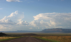
State Route 66 tends downward toward the west, with the vegetation becoming more desert-like toward Kingman. The terrain changes at a slower pace than the more direct Interstate 40, making it a scenic alternative at the cost of some time. It still serves communities that the freeway avoids, including Valentine
and Peach Springs
; it enters the Hualapai Indian Reservation.
 Between the California
state line and Kingman, the original alignment is now known as Oatman Road and passed through the old mining town of Oatman
. A later alignment (via Yucca
) is now Interstate 40. The older alignment passes through the Black Mountains
complete with numerous hairpin turns. This area is desert.
From Kingman to Seligman, it followed modern State Route 66 as described above. Much of old 66 all the way to the New Mexico
state line has been replaced with I-40. Older stretches of the highway exist as frontage road
s and business loops of I-40. Between Seligman to east of Flagstaff
, the area is mountainous (not desert) and covered with pine
forests. The old section through Flagstaff itself is officially named "Route 66". Shortly before joining I-40 east of Flagstaff, US 66 passes through Winona
, a small unincorporated community made famous in the song "(Get Your Kicks on) Route 66
".
The Meteor Crater
is south of old US 66 at Meteor City. at Joseph City
is the Jack Rabbit Trading Post
, which once posted signs up and down the highway for hundreds of miles, and at Holbrook
is the Wigwam Village Motel, a motor court built to resemble a group of teepees. About sixty miles before reaching New Mexico, the highway originally passed through the Painted Desert
, though this section is now cut off.
for maintenance.
U.S. state
A U.S. state is any one of the 50 federated states of the United States of America that share sovereignty with the federal government. Because of this shared sovereignty, an American is a citizen both of the federal entity and of his or her state of domicile. Four states use the official title of...
of Arizona
Arizona
Arizona ; is a state located in the southwestern region of the United States. It is also part of the western United States and the mountain west. The capital and largest city is Phoenix...
in Mohave and Coconino
Coconino County, Arizona
-2010:Whereas according to the 2010 U.S. Census Bureau:*61.7% White*1.2% Black*27.3% Native American*1.4% Asian*0.1% Native Hawaiian or Pacific Islander*3.1% Two or more races*5.2% Other races*13.5% Hispanic or Latino -2000:...
Counties.
Route description
The road continues east into Yavapai County as a county-maintained road that is not officially part of the state highway system. State Route 66 is a relic of the former U.S. Route 66U.S. Route 66
U.S. Route 66 was a highway within the U.S. Highway System. One of the original U.S. highways, Route 66 was established on November 11, 1926 -- with road signs erected the following year...
(US 66), and is the only part of old US 66 in Arizona to have state route markers. Its western terminus is near Kingman
Kingman, Arizona
Kingman is located in a desert climate on the edge of the Mojave Desert, but its higher elevation and location between the Colorado Plateau and the Lower Colorado River Valley tempers summer high temperatures and contributes to winter cold and rare snowfall. Summer daytime highs reach above 90 °F ...
at exit 52 on Interstate 40 and its eastern terminus lies near Seligman
Seligman, Arizona
Seligman is a census-designated place in Yavapai County, Arizona, United States. The population was 456 at the 2000 census.-History:Between 1889-1891, Seligman was established by the Theut and Moultrie families. Both were prosperous slaughterhouse owners in Southern antebellum families who lost...
at exit 123 on Interstate 40.
State Route 66 tends downward toward the west, with the vegetation becoming more desert-like toward Kingman. The terrain changes at a slower pace than the more direct Interstate 40, making it a scenic alternative at the cost of some time. It still serves communities that the freeway avoids, including Valentine
Valentine, Arizona
Valentine is an unincorporated community in Mohave County, Arizona, United States. Valentine is located on Arizona State Route 66 northeast of Kingman. Valentine has a ZIP Code of 86437; in 2000, the population of the 86437 ZCTA was 36....
and Peach Springs
Peach Springs, Arizona
Peach Springs is a census-designated place in Mohave County, Arizona, United States. The population was 600 at the 2000 census. Peach Springs serves as the administrative headquarters of the Hualapai people, and is located on the Hualapai Reservation.-Geography:Peach Springs is located at ...
; it enters the Hualapai Indian Reservation.
U.S. Route 66 in Arizona
California
California is a state located on the West Coast of the United States. It is by far the most populous U.S. state, and the third-largest by land area...
state line and Kingman, the original alignment is now known as Oatman Road and passed through the old mining town of Oatman
Oatman, Arizona
Oatman is a former mining town in the Black Mountains of Mohave County, Arizona, United States. Located at an elevation of , it began as a tent camp soon after two prospectors struck a $10 million gold find in 1915, though the area had been already settled for a number of years. Oatman's...
. A later alignment (via Yucca
Yucca, Arizona
Yucca is an unincorporated community in Mohave County, Arizona, United States. Located along Interstate 40, it lies southwest of Kingman, just east of the southern section of the Black Mountains and west of the Hualapai and McCracken Mountains in the Sacramento Valley. Yucca has a ZIP Code of...
) is now Interstate 40. The older alignment passes through the Black Mountains
Black Mountains (Arizona)
The Black Mountains of northwest Arizona are an extensive, mostly linear, north-south 75-mile long mountain range. It forms the north-south border of southwest Mohave County as it borders the eastern shore of the south-flowing Colorado River from Hoover Dam.The northwest, and parts of the west of...
complete with numerous hairpin turns. This area is desert.
From Kingman to Seligman, it followed modern State Route 66 as described above. Much of old 66 all the way to the New Mexico
New Mexico
New Mexico is a state located in the southwest and western regions of the United States. New Mexico is also usually considered one of the Mountain States. With a population density of 16 per square mile, New Mexico is the sixth-most sparsely inhabited U.S...
state line has been replaced with I-40. Older stretches of the highway exist as frontage road
Frontage road
A frontage road is a non-limited access road running parallel to a higher-speed road, usually a freeway, and feeding it at appropriate points of access...
s and business loops of I-40. Between Seligman to east of Flagstaff
Flagstaff, Arizona
Flagstaff is a city located in northern Arizona, in the southwestern United States. In 2010, the city's population was 65,870. The population of the Metropolitan Statistical Area was at 134,421 in 2010. It is the county seat of Coconino County...
, the area is mountainous (not desert) and covered with pine
Pine
Pines are trees in the genus Pinus ,in the family Pinaceae. They make up the monotypic subfamily Pinoideae. There are about 115 species of pine, although different authorities accept between 105 and 125 species.-Etymology:...
forests. The old section through Flagstaff itself is officially named "Route 66". Shortly before joining I-40 east of Flagstaff, US 66 passes through Winona
Winona, Arizona
Winona is a small unincorporated community in Coconino County in the northern part of the U.S. state of Arizona.It is located along U.S. Route 66 and was made famous in the song " Route 66"...
, a small unincorporated community made famous in the song "(Get Your Kicks on) Route 66
Route 66 (song)
" Route 66", often rendered simply as "Route 66", is a popular song and rhythm and blues standard, composed in 1946 by American songwriter Bobby Troup. It was first recorded in the same year by Nat King Cole, and was subsequently covered by many artists including Chuck Berry in 1961, The Rolling...
".
The Meteor Crater
Meteor Crater
Meteor Crater is a meteorite impact crater located approximately east of Flagstaff, near Winslow in the northern Arizona desert of the United States. Because the US Department of the Interior Division of Names commonly recognizes names of natural features derived from the nearest post office, the...
is south of old US 66 at Meteor City. at Joseph City
Joseph City, Arizona
Joseph City is an unincorporated community located in Navajo County, Arizona, United States. It is located on Interstate 40 about eighty miles east of Flagstaff....
is the Jack Rabbit Trading Post
Jack Rabbit Trading Post
The Jack Rabbit Trading Post is a convenience store and curio shop located on former U.S. Route 66, five miles west of Joseph City, Arizona city limits off of Exit 274 on Interstate 40. The trading post hails from Route 66's glory days, and is currently in operation...
, which once posted signs up and down the highway for hundreds of miles, and at Holbrook
Holbrook, Arizona
-Historical events:*During 1881 & 1882, railroad tracks were laid down and a railroad station was built. The community was then named Holbrook after the first engineer of the Atlantic and Pacific Railroad...
is the Wigwam Village Motel, a motor court built to resemble a group of teepees. About sixty miles before reaching New Mexico, the highway originally passed through the Painted Desert
Painted Desert, Arizona
The Painted Desert is a area of badlands located in Northern Arizona in the United States. The Arizona desert stretches from the Grand Canyon National Park into the Petrified Forest National Park and runs roughly astride and just north of the Little Colorado and the Puerco Rivers...
, though this section is now cut off.
State route
In 1984, US 66 was officially removed from the state highway system of Arizona. Most of the old highway had been replaced by I-40, but the portion between Kingman and Seligman where I-40 followed a new alignment to the south became SR 66. In 1990, the state turned over the easternmost 16.8 miles (27 km) of SR 66 (known as Crookston Rd) to Yavapai CountyYavapai County, Arizona
-2010:Whereas according to the 2010 U.S. Census Bureau:*89.3% White*0.6% Black*1.7% Native American*0.8% Asian*0.1% Native Hawaiian or Pacific Islander*2.5% Two or more races*5.0% Other races*13.6% Hispanic or Latino -2000:...
for maintenance.
Junction list
| County | Location | Mile | Junction | Notes |
|---|---|---|---|---|
| Mohave Mohave County, Arizona Mohave County is located in the northwestern corner of the U.S. state of Arizona. As of the 2010 census, its population was 200,186, an increase of 45,154 people since the 2000 census count of 155,032. The county seat is Kingman... |
McConnico | 0.00 | ||
| 0.40 | Unknown road | Road not named on Mapquest | ||
| Kingman Kingman, Arizona Kingman is located in a desert climate on the edge of the Mojave Desert, but its higher elevation and location between the Colorado Plateau and the Lower Colorado River Valley tempers summer high temperatures and contributes to winter cold and rare snowfall. Summer daytime highs reach above 90 °F ... |
2.70 | Unknown road | ||
| 4.98 | Ella's Place | Becomes W Andy Devine Avenue | ||
| 5.15 | N 1st Street | |||
| 5.25 | 2nd Street | Becomes E Andy Devine Avenue | ||
| 5.34 | N 3rd Street | |||
| 5.43 | 4th Street | |||
| 5.52 | N 5th Street | |||
| 5.66 | N 6th Street | |||
| 5.76 | N 7th Street | |||
| 5.85 | 8th Street | |||
| 5.92 | ||||
| 5.97 | N 9th Street | |||
| 6.08 | N 10th Street | |||
| 6.22 | E Beale Street | |||
| 6.32 | Chadwick Drive | |||
| 6.56 | ||||
| 6.69 | Maple Street | |||
| 6.79 | Hall Street | |||
| 6.90 | Stockton Hall Road (going NW)/Hualapai Mountain Road (going SE) | |||
| 7.02 | Johnson Street | |||
| 7.05 | Virginia Avenue | |||
| 7.23 | Sunset Boulevard | |||
| 7.64 | Harrison Street | |||
| 7.97 | Airfield Avenue | |||
| 8.19 | Navajo Street | |||
| 8.30 | Airfield Avenue | |||
| 8.41 | Tucker Street | |||
| 8.53 | Detroit Avenue | |||
| 8.66 | Michael Street | |||
| 8.78 | Bruce Street | Westbound only | ||
| 8.89 | ||||
| 9.17 | Armour Avenue | |||
| 9.54 | Airway Avenue | |||
| 9.60 | Shangri La Drive | Westbound only | ||
| 9.96 | Horizon Boulevard | |||
| 10.47 | N Castle Rock Road | |||
| 10.85 | Gordon Drive | |||
| 11.00 | E Martin Lane | Westbound only | ||
| 11.20 | Dove Lane | |||
| 11.39 | E Diagonal Way | |||
| 11.79 | Sunhaven Avenue | |||
| 12.11 | Unknown road | Road not named on Mapquest | ||
| 12.13 | Northfield Avenue | |||
| 12.19 | E John L Avenue | |||
| 12.23 | Shaeffer Avenue | |||
| 12.29 | Devlin Avenue | Westbound only | ||
| 12.39 | Ryan Avenue | |||
| 12.43 | Lum Avenue | |||
| 12.49 | E Thompson Avenue | |||
| 13.05 | Long Mountain Road | |||
| 13.61 | E Mohave Airport Drive | |||
| 15.29 | E Brechler Drive | Not called E Andy Devine Avenue after this intersection | ||
| 17.94 | Unknown road | Road not named on Mapquest | ||
| Walapai Walapai, Arizona Walapai is an unincorporated community in Mohave County, Arizona, United States. Walapai is located along a railroad line northeast of Kingman. Walapai has a post office with ZIP code 86412.... |
20.39 | Unknown road | ||
| 21.25 | Unknown road | |||
| 22.92 | Ironwood Drive | |||
| 23.26 | Olympic Avenue | |||
| 23.31 | E Concho Drive | |||
| 24.47 | Buckboard Drive | |||
| 24.72 | Apache Drive | |||
| Antares | 26.50 | Boulder Drive | ||
| 27.00 | Antares Road | |||
| 29.15 | Unknown road | Road not named on Mapquest | ||
| Coconino Coconino County, Arizona -2010:Whereas according to the 2010 U.S. Census Bureau:*61.7% White*1.2% Black*27.3% Native American*1.4% Asian*0.1% Native Hawaiian or Pacific Islander*3.1% Two or more races*5.2% Other races*13.5% Hispanic or Latino -2000:... |
66.59 | Temporary end of SR 66 |