

Stanwick St John
Encyclopedia
Civil parish
In England, a civil parish is a territorial designation and, where they are found, the lowest tier of local government below districts and counties...
in the Richmondshire
Richmondshire
Richmondshire is a local government district of North Yorkshire, England. It covers a large northern area of the Yorkshire Dales including Swaledale and Arkengarthdale, Wensleydale and Coverdale, with the prominent Scots' Dyke and Scotch Corner along the centre. Teesdale lies to the north...
district of North Yorkshire
North Yorkshire
North Yorkshire is a non-metropolitan or shire county located in the Yorkshire and the Humber region of England, and a ceremonial county primarily in that region but partly in North East England. Created in 1974 by the Local Government Act 1972 it covers an area of , making it the largest...
, England
England
England is a country that is part of the United Kingdom. It shares land borders with Scotland to the north and Wales to the west; the Irish Sea is to the north west, the Celtic Sea to the south west, with the North Sea to the east and the English Channel to the south separating it from continental...
. It is situated between the towns of Darlington
Darlington
Darlington is a market town in the Borough of Darlington, part of the ceremonial county of County Durham, England. It lies on the small River Skerne, a tributary of the River Tees, not far from the main river. It is the main population centre in the borough, with a population of 97,838 as of 2001...
and Richmond
Richmond, North Yorkshire
Richmond is a market town and civil parish on the River Swale in North Yorkshire, England and is the administrative centre of the district of Richmondshire. It is situated on the edge of the Yorkshire Dales National Park, and serves as the Park's main tourist centre...
, close to Scotch Corner
Scotch Corner
Scotch Corner is an important junction of the A1 and A66 trunk roads near Richmond, North Yorkshire, England. It has been described as "the modern gateway to Cumbria, the North East and Scotland".-Geography:...
and the remains of the Roman
Ancient Rome
Ancient Rome was a thriving civilization that grew on the Italian Peninsula as early as the 8th century BC. Located along the Mediterranean Sea and centered on the city of Rome, it expanded to one of the largest empires in the ancient world....
fort and bridge at Piercebridge
Piercebridge
Piercebridge is a village and civil parish in the borough of Darlington and the ceremonial county of Durham, England. It is situated a few miles west of the town of Darlington. It is on the site of a Roman fort of AD 260-270, which was built at the point where Dere Street crossed the River Tees....
.
The name 'Stanwick' is thought to be derived from the Old Norse
Old Norse
Old Norse is a North Germanic language that was spoken by inhabitants of Scandinavia and inhabitants of their overseas settlements during the Viking Age, until about 1300....
word 'steinvegges', meaning stone ways. It has been established that in 1225, Stanwick was known as 'Steinweg' ; a contemporary document concerning a dispute over church revenue, which led to the church being attacked and the vicar barricading himself inside, refers to 'murder, fire and sacrilege within the church at Steinweg'.
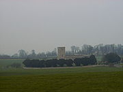
Not much remains of the once thriving settlement at Stanwick except the parish church, the Church of St John The Baptist
St John the Baptist's Church, Stanwick
St John the Baptist's Church, Stanwick, is a redundant Anglican church in the village of Stanwick St John, North Yorkshire, England . It has been designated by English Heritage as a Grade I listed building, and is under the care of the Churches Conservation Trust...
. The present church dates from the 13th century , although large sections of it were rebuilt during architect Anthony Salvin
Anthony Salvin
Anthony Salvin was an English architect. He gained a reputation as an expert on medieval buildings and applied this expertise to his new buildings and his restorations...
's major restoration of the building in 1867-8, which was executed under the auspices of the Dowager Duchess of Northumberland
Duke of Northumberland
The Duke of Northumberland is a title in the peerage of Great Britain that has been created several times. Since the third creation in 1766, the title has belonged to the House of Percy , which held the title of Earl of Northumberland from 1377....
who lived at, the now demolished, Stanwick Park
Stanwick Park
Stanwick Park was a palladian country house at Stanwick St John in Yorkshire. It was re-built by the 1st Duke of Northumberland, a great patron of the arts, c1739-1740, mostly to his own designs. The Duke's principal seat was Alnwick Castle thus Stanwick Park was always a secondary residence...
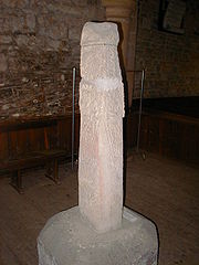
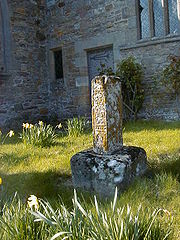
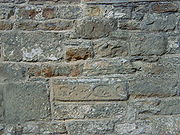
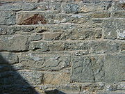
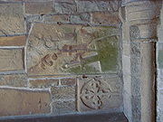
. The remains of a 9th centurycross-shaft in the tower and a number of carved stones set into the walls suggest an earlier building may have occupied the site . Its location in an unusual circular churchyard also hints at a possible pre-Norman conquest burial ground. The church has not held regular services since 1990, although it remains consecrated.
Completely surrounding the village of Stanwick St John are Stanwick Iron Age Fortifications
Stanwick Iron Age Fortifications
Stanwick Iron Age Fortifications , a huge Iron Age hill fort comprising over of ditches and ramparts enclosing approximately 300 hectares of land, are situated in Richmondshire, North Yorkshire, England...
, a huge Iron Age
Iron Age
The Iron Age is the archaeological period generally occurring after the Bronze Age, marked by the prevalent use of iron. The early period of the age is characterized by the widespread use of iron or steel. The adoption of such material coincided with other changes in society, including differing...
hill fort
Hill fort
A hill fort is a type of earthworks used as a fortified refuge or defended settlement, located to exploit a rise in elevation for defensive advantage. They are typically European and of the Bronze and Iron Ages. Some were used in the post-Roman period...
comprising six miles (10 km) of ditches and ramparts enclosing over 700 acres (2.8 km²) of land.
Some archaeologists and historian
Historian
A historian is a person who studies and writes about the past and is regarded as an authority on it. Historians are concerned with the continuous, methodical narrative and research of past events as relating to the human race; as well as the study of all history in time. If the individual is...
s believe that these massive fortifications enclosed the ancient fort of Rigodunum, the capital of Brigantia
Brigantes
The Brigantes were a Celtic tribe who in pre-Roman times controlled the largest section of what would become Northern England, and a significant part of the Midlands. Their kingdom is sometimes called Brigantia, and it was centred in what was later known as Yorkshire...
, possibly occupied by Cartimandua
Cartimandua
Cartimandua or Cartismandua was a queen of the Brigantes, a Celtic people in what is now Northern England, in the 1st century. She came to power around the time of the Roman conquest of Britain, and formed a large tribal agglomeration that became loyal to Rome...
, Queen of the Brigantes, or her rival and ex-husband, Venutius .
Early Period
Traces of the early human occupation of the ancient site now known as Stanwick Camp are everywhere about: the snaking dykes enclose a roughly triangular area of 300 hectares (740 acres) with an internal defensible sector, now a meadow known as the Tofts south of the church. Excavations in 1951 (WheelerMortimer Wheeler
Brigadier Sir Robert Eric Mortimer Wheeler CH, CIE, MC, FBA, FSA , was one of the best-known British archaeologists of the twentieth century.-Education and career:...
) and during the 1980s (Haselgrove) have revealed traces of round houses both within the Tofts and outside the larger enclosed area suggesting that from about 200BC agrarian settlers began to establish what became the largest oppidum in the north of England. Traces of Samian and other rich goods in one of the round-house remains suggest that Cartimandua
Cartimandua
Cartimandua or Cartismandua was a queen of the Brigantes, a Celtic people in what is now Northern England, in the 1st century. She came to power around the time of the Roman conquest of Britain, and formed a large tribal agglomeration that became loyal to Rome...
, Queen of the Brigantes (who, thanks to a short mention in Tacitus
Tacitus
Publius Cornelius Tacitus was a senator and a historian of the Roman Empire. The surviving portions of his two major works—the Annals and the Histories—examine the reigns of the Roman Emperors Tiberius, Claudius, Nero and those who reigned in the Year of the Four Emperors...
’ history, is known to have made a pact with the rapidly advancing Romans under Petillius Cerealis) may have made it her (temporary) residence. Rigodonum, a Brigantian
Brigantes
The Brigantes were a Celtic tribe who in pre-Roman times controlled the largest section of what would become Northern England, and a significant part of the Midlands. Their kingdom is sometimes called Brigantia, and it was centred in what was later known as Yorkshire...
fort of unknown location mentioned by Tacitus, has been proposed by Mortimer Wheeler as a likely candidate for the location now known as Stanwick. There are here no signs of battle in the archaeological record; the Romans established stations at Catterick
Catterick, North Yorkshire
Catterick , sometimes Catterick Village, to distinguish it from the nearby Catterick Garrison, is a village and civil parish in the Richmondshire district of North Yorkshire, England...
to the south and Piercebridge
Piercebridge
Piercebridge is a village and civil parish in the borough of Darlington and the ceremonial county of Durham, England. It is situated a few miles west of the town of Darlington. It is on the site of a Roman fort of AD 260-270, which was built at the point where Dere Street crossed the River Tees....
at the river crossing to the north but at about the same time (ca 70AD) building activity seems to have stopped at Stanwick.
Another contemporary walled ditch called Scots Dyke running from Stanwick as far south as the river Swale at Richmond (and possibly also north over the Tees
River Tees
The River Tees is in Northern England. It rises on the eastern slope of Cross Fell in the North Pennines, and flows eastwards for 85 miles to reach the North Sea between Hartlepool and Redcar.-Geography:...
at Gainford
Gainford, County Durham
Gainford on Tees is a village on the north bank of the River Tees in County Durham, England. It is half-way between Barnard Castle and Darlington, near Winston, at OS map reference NZ 1716....
) may have formed part of a general defensive mechanism for the hill peoples in the area.
An English Heritage
English Heritage
English Heritage . is an executive non-departmental public body of the British Government sponsored by the Department for Culture, Media and Sport...
visitor site just outside the village of Forcett contains a section of the defences rebuilt by Sir Mortimer Wheeler showing how the ditch was at this point actually cut down into the native sandstone and this used for a wall on the inner side. However, the very length of the perimeter of the site (more than 6 km) suggests that defence against a strong attack would hardly have been an option.
(A leaflet ‘Stanwick Camp’ is available from North Yorkshire County Council, countryside@northyorks.gov.uk Articles from the ‘Stanwick Hoard’ discovered nearby in 1854 are to be seen in the British Museum
British Museum
The British Museum is a museum of human history and culture in London. Its collections, which number more than seven million objects, are amongst the largest and most comprehensive in the world and originate from all continents, illustrating and documenting the story of human culture from its...
in London
London
London is the capital city of :England and the :United Kingdom, the largest metropolitan area in the United Kingdom, and the largest urban zone in the European Union by most measures. Located on the River Thames, London has been a major settlement for two millennia, its history going back to its...
, and archaeological reports of digs in the 1980s can be read in the Archaeological Journal 147 (1990), Haselgrove et al.)
Post-Roman
While Stanwick was never an important settlement after the Romans built and marched up what is now called Dere Street, from Catterick fort towards their river crossing at Piercebridge, it seems that the centre of the area below the Tofts, with its watermeadows, stream and pasture, which became built up into the circular, sacred island-like site visible today provided a place for Christian worship and a burial ground as early as 500 AD. Traces of a small Iron Age village have been identified a little to the north-east of the church, and particularly in wet conditions early cultivation patterns are clearly visible in all the surrounding fields. Some very early carved stones with Viking ornamentation are to be seen built into the walls of the chancel and the porch, and an Anglo-Saxon cross-shaft with Celtic scrollwork is in the church.After the Conquest
As early as 1066 ‘one Tor held 3 carucates of land here at Stanwegge’. (A carucate is a notional area to do with the rate of oxen ploughing, probably around 150 acres). It became Stanwigs and then Stanwick, probably derived from ‘stone walls’. By 1275 the Templars and then by 1348 the Knights Hospitallers took over the settlement, but within the next fifty years it was transferred into the hands of the Catherick family (the village of Catterick lies, with its Roman remains, some five miles (8 km) to the south). They built the Old Hall, still in use, opposite the church where an Elizabeth Catherick is remembered with a brass plate dated 1591.They finally sold the house and estate to Hugh Smithson, successful ‘citizen and haberdasher’ of London, in 1638, for £4000. His grandfather had lived at Stanwick, so he was coming home. The hamlet was then 600 acres (about 250 hectares) with four dwelling houses and six cottages. By 1750 his great grandson Hugh married Elizabeth Seymour, the daughter of the Earl of Northumberland. The Earl had no male offspring, but quickly changing his name from Smithson to Percy - at a stroke the problem was solved. He qualified for the title of the fourth Baronet - and subsequently became Duke of Northumberland. By 1763 the Royal Arms had been painted above the Chancel (at a cost of £5), the church floor had been flagged, and new pews and a gallery under the tower built.
Despite the fact that the official seat of the Northumberlands was at Alnwick, sixty miles to the north, family ties were important and he moved to build a splendid new Stanwick Hall half a mile to the south which he would use as a country retreat. The beck was bridged and an approach drive constructed to link with the neighbouring village of Aldbrough, Dere Street
Dere Street
Dere Street or Deere Street, was a Roman road between Eboracum and Veluniate, in what is now Scotland. It still exists in the form of the route of many major roads, including the A1 and A68 just north of Corbridge.Its name corresponds with the post Roman Anglo-Saxon kingdom of Deira, through...
and the outside world. The new Hall, complete with splendid summerhouse and deer park, was painted upon its completion by George Cuitt the Elder
George Cuitt the Elder
George Cuitt the Elder was born at Moulton, in Yorkshire, in 1743, and having shown a natural taste for drawing and design was sent to Italy at the expense of Sir Lawrence Dundas, whose family had already been painted by him. He studied earnestly for six years at Rome, and also pursued landscape...
(1743-1818), who was born at nearby Moulton; the picture is to be seen at Syon House, London, to this day.
Soon a new century had arrived, and the gardens were being built – an Italian style sunken garden with fountain immediately south of the entrance; a splendid 1 acres (4,046.9 m²) walled French Garden (designed allegedly by an émigré French priest – escaping the Revolution?) and a 2 acres (8,093.7 m²) walled kitchen garden further to the east. Soon the seventh duke was in charge, Algernon, who married Eleanor Grosvenor in 1842, and more alterations began at Stanwick Hall. Perhaps that was when the icehouse was sunk in the Tofts to the SW of the church, with a handsome ornamental ‘Deer Shelter’ on top. He was a naval officer, explorer and social innovator, expanding enormously his estates with the revenue from the coal industry and the railways; he was buried with some pomp in Westminster Abbey
Westminster Abbey
The Collegiate Church of St Peter at Westminster, popularly known as Westminster Abbey, is a large, mainly Gothic church, in the City of Westminster, London, United Kingdom, located just to the west of the Palace of Westminster. It is the traditional place of coronation and burial site for English,...
, in 1864, leaving the estate ‘for her lifetime’ to his distraught and childless widow.
She did not pause; soon the church was rebuilt (by Anthony Salvin) from its parlous condition, many of the historical stones from the older buildings and tombs being set in its walls and porch. A new Vicarage was built to the north (and presented with a portrait of the late Duke); lodges and stout residences for her Butler and Head Gardener were added. Later, in 1891, she commissioned a new church (St Paul’s) to be built in Aldbrough St John nearby. (That village - itself of ancient foundation - was already largely the property of the Northumberlands. and always had been the source of workers and services for the estate.) An interesting record of the Hall and its land was made in 1900, when Country Life Illustrated's edition of February 17 featured a well-illustrated article entitled 'Stanwick Park, Yorkshire - the seat of Eleanor, Duchess of Northumberland". This included seven photographs of the house and gardens and associated statuary and ironwork. In only one of the published pictures is a living person -Mr William Higgie, her Head Gardener, employed in 1866 and discharged only following her death in 1911.
The Dowager Duchess Eleanor
Eleanor Percy, Duchess of Northumberland
Eleanor Percy, Duchess of Northumberland was the wife of Algernon Percy, 4th Duke of Northumberland.-Biography:Elearnor was born on 22 October 1820, the daughter of Richard Grosvenor, 2nd Marquess of Westminster and Lady Elizabeth Mary Leveson-Gower. She married Algernon Percy, 4th Duke of...
lived on to the age of 90, spending about half the year in residence and seeing to the spiritual needs of the community, reducing the number of pubs to one, supporting the school and dispensing charity to the deserving.
After her death the house was less and less used by the family, and was briefly a hospital for wounded from the First World War. With the severe imposition of death duties after that war the upkeep of the house and grounds became uneconomic and in 1923 the Northumberland family sold all its farms and land in the area; the house failed to find a buyer and was demolished. Most of the associated buildings were successfully sold – the large kitchen garden became a commercial enterprise and the cottages and outbuildings were taken up and converted to modern dwellings. The result was a small nuclear village of some ten properties which has since expanded slightly but still remains within the original estate boundaries. Googling the place still clearly reveals the plan of the estate (minus the house itself).
The neighbouring estate of Carlton, half a mile to the north-east, had been subsumed by Stanwick Hall early in the nineteenth century and was the residence of the overall estate manager, stables and kennels and associated estate staff accommodation. Its fate echoed that of Stanwick: the Hall was demolished and it is now also a group of refurbished estate walls and buildings, including an icehouse and traces of walled gardens.