

Stanley Mitchell hut
Encyclopedia
The Stanley Mitchell hut is an alpine hut located at an altitude of 2060 m (6,825 feet)in the Little Yoho Valley in Yoho National Park
, British Columbia
. It sits in a small meadow not far from the base of a mountain called The President
. It serves as a base for hiking, scrambling, ski-touring and climbing the nearby mountains. The hut is maintained by the Alpine Club of Canada
.
and Elizabeth Parker, Stanley Mitchell
was responsible for founding the Alpine Club of Canada
in 1906, and from 1907 to 1930 he served as its Secretary-Treasurer. He had a great reputation as a gentleman among his fellow founders and the executive of the club, as well as the members he met at the club house in Banff
. He died in 1940, shortly after the hut which bears his name was completed.
The Little Yoho Valley has long had a reputation as an excellent alpine climbing area as well as a magnificent skiing area. The Canadian military used the area during the summer of 1943 as a training site for mountaineering techniques. From 1954 to the mid-70s mountaineering legend Hans Gmoser
used the hut as a base for his ski touring operation - a company which eventually became the heli-skiing operator Canadian Mountain Holidays.
The hut has undergone a few renovations, but is relatively the same as it was in 1940. It is presently in excellent condition; a comfortable facility set in beautiful meadow and mountain terrain, and a fine memorial to one of the Club's founders.
The Stanley Mitchell hut was designated a Federal Heritage Building in 1997.
, 21 km west of Lake Louise, Alberta
and 3.7 km east of Field, British Columbia
. The turn-off to the trailhead is signed as Takakkaw Falls
on the highway. Follow the Yoho Valley Road to the Takakkaw Falls parking lot (13 km from the highway). In summer, park at the most northerly point (closest to the Parks Canada campground). In winter, follow the Yoho Valley Road for approximately 1 km and park at the locked gate. The rest of the road is unplowed in winter.
The two common approaches to the Stanley Mitchell hut are the Little Yoho Valley trail and the Iceline Trail. Both originate at the Takakkaw Falls
parking lot and follow well-developed National Park trail systems. It is more common to approach the hut on the former trail, and to hike the Iceline on the descent, to avoid the immediate grueling uphill of this trail. Descending the Iceline allows you to hike toward, rather than away from, the spectacular scenery surrounding the trail. You will end up about 1 km from your car if you approach the hut on the Little Yoho Valley Trail and descend the Iceline trail.
The Little Yoho Valley is the most common way of getting to the hut. The trails are well developed and maintained, the route is well graded, and (including a few short optional diversions), very scenic. The standard hiking time in the summer is three to four hours but, because a lot of parties use this hut as one of their first backpacking trips and as an introduction to backcountry adventures, it can be underestimated.
Begin hiking on the Little Yoho Valley and Twin Falls
trail (signed). You will pass the campground almost immediately. The trail is mostly level for about the first 4 km, and begins gaining elevation after passing Laughing Falls. At Laughing Falls you will come to a trail junction which leads to Twin Falls to the right, and the Little Yoho Valley to the left; keep left here, and hike up the switchbacks. There is another trail junction for Marpole Lake about 0.5 km before reaching the top of the Laughing Falls hill. Stay left on the trail which continues to climb the hill. Half a kilometre further, at the top of the elevation gain, you will come to another junction indicating the Whaleback
trail to your right, and the Little Yoho Valley to the left; go left here, and then to the right at the next junction which is less than 100 m further. In approximately another 3 km you will come to an open meadow and the Stanley Mitchell Hut.
The Iceline Trail provides spectacular views of Takakkaw Falls and the glaciers beyond; you can picture where the Scott Duncan hut lies north of Mount Daly
on the southern end of the Waputik Icefield
. This trail is more commonly used descending from the hut, making a great loop trail. Early in the summer, the trail can be difficult to follow and you may need an ice axe
to safely cross some of the snow slopes.
From the Takakkaw Falls parking lot, the trail rises about 600 m (2,000 ft) and descends about 100 m (330 ft) over 11 km. Most of the elevation gain takes place within the first couple of kilometers. It usually takes 3–5 hours. Drive up the Yoho Valley Road as described above. Leave your car at the parking lot beside the Whiskey Jack Hostel, just before Takakkaw Falls. The trail starts a couple of hundred metres north of the hostel. Climb the trail up the hillside above, through the forest to the left of a giant avalanche slide path. After 1 km there is a junction for a side trip to Hidden Lake to the left, and a couple of hundred metres further, a junction for Yoho Pass and Yoho Lake to the left. Keep right at both of these intersections. The trail continues rising, then levels out and follows well-developed trails on moraine
on the northeast side of the President Range
, before dropping down to the Little Yoho River
and the Stanley Mitchell hut.
The information below describes the character and difficulty of the undertaking, but is inadequate for planning or carrying out the trips themselves. Refer to Ski Trails in the Canadian Rockies by Chic Scott, or Summits & Icefields: Canadian Rockies by Chic Scott for complete access information
Two routes are commonly used to access the hut in winter: the Little Yoho Valley approach, which gives access from the highway in a long one-day push, and the less common multi-day Yoho Traverse across the des Poilus Glacier
from the Wapta Icefield
. Both routes are serious undertakings, and as a result this hut is used much less in the winter than in the summer months.
On the Little Yoho Valley approach, the road to Takakkaw Falls is not plowed in winter, and must be skied. The first 5 km are normally trackset. After arriving at the Takakkaw Falls, the route follows the one taken in summer. The ascent from the highway to the hut is approximately 700 m (2,200 ft) over 23 km. Allow a full day for this approach – longer if you are breaking trail. Many people split the trip into two days, with a bivouac at the campground cook shelter just past Takakkaw Falls. There are no amenities at the shelter.
The route follows the road to Takakkaw Falls and the summer hiking trail to the hut. The trail signs may be completely under snow, and the final stretch to the hut may be difficult to follow if a trail has not been broken or if the sun goes down.
The Yoho Traverse is a major, multi-day ski tour with a couple of variations. You can begin at either Bow hut
or Peyto hut, or the Icefield Parkway. It is possible to push through to Stanley Mitchell hut in a day from Bow hut, but most parties camp out one night on the des Poilus Glacier. The summary below assumes a start at the Bow hut.
From Bow hut you gain about 820 m (2,700 ft), and lose about 1100 m (3,600 ft) over 20 km. The route is sometimes done in a full day from the Bow hut, but many parties plan on two days. A night out should be planned for, even if not anticipated. The route crosses the Wapta Icefield
to the west through the Mount Rhondda
- Mount Gordon
pass and across the southeast slopes of Mount Collie
before descending south onto the des Poilus Glacier
. It passes Isolated Peak on its east side, and descend its south slopes to the hut.
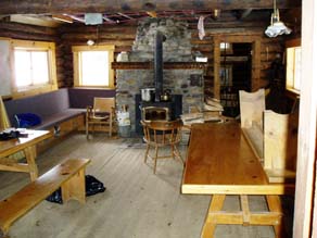
 The Stanley Mitchell hut is a -storey log building
. The hut consists of a large kitchen area and a living/dining room with tables, seats and a wood burning stove. It has a good supply of tools including water buckets, axes, saws, shovels, etc.
The hut sleeps 24 in summer and 20 in winter. The sleeping quarters have 4 inches (101.6 mm) covered foam mattresses and are in a small room on the main floor and a large upstairs loft
. Sleeping arrangements are dormitory-style, on two long bunks (bring earplugs!).
The hut is lit by several propane
lights. It has a wood-burning stove
for heating and drying clothes. Firewood
is stored behind the hut. Please replace all firewood you use in the hut with cut and split wood from the pile.
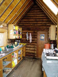
The kitchen is well supplied with dishes, cutlery, utensils, pots and pans and bake ware (including roasting pans, cookie sheets, coffee percolator, bread pans and muffin pans). There is a full size propane oven
, as well as some two-burner propane stove
s for cooking. Propane
is supplied by the Alpine Club via a large outdoor tank
. Drinking water
is available from a small stream fed by Kiwetinok lake (a day hike) running through the meadow
60 m south of the hut. It is advisable to boil or treat
the water before drinking it. In the winter you can dig down to the creek or melt snow
for water.
Grey water disposal is in a ground sump
next to the hut. Grey water can be drained directly down the sinks, but it is important to ensure that the strainer is in place under the drain. Food scraps (including coffee grounds) should not be allowed to enter the grey water sump or it will become plugged. Periodically, the strainer contents should be emptied into the fireplace. The grey water sump occasionally freezes in the winter, in which case the grey water (strained of food particles) should be dumped within a three meter radius of the outhouse.
The outhouse
is located 30 m west of the front door of the main hut. No garbage
should be dumped in the outhouse. All paper garbage and food scraps should be burned, and all other garbage and unused food should be packed out.
on established trails in the vicinity of the hut is excellent, with interesting trips back down the valley toward Twin Falls (such as the Whaleback trail and the Marpole Lake trail) as well as up past the hut toward Kiwetinok Pass.
The big mountaineering
objectives of the area are The President
and the Vice President
. The routes from the col between the two peaks are excellent moderate mountaineering challenges that see a fair number of beginners brought along. The Vice President also offers a very good snow and ice route on the north face. The North Ridge and East Face of Mount McArthur
to the northwest are also very good alpine outings.
Besides the President and Vice President, the other peaks in the area are primarily scrambling
outings. Some of the most common objectives are Mount Kerr, Mount Polinger, Kiwetinok Peak and Isolated Peak. There is also very good scrambling along Whaleback Mountain.
Author Chic Scott raves about the backcountry skiing
in the Little Yoho Valley in the winter, referring to both the skiing terrain and the warmth and atmosphere at the Stanley Mitchell Hut. According to Chic, the valley, with its perfect terrain, excellent snow and ski runs which end at the door of the hut is the Gem of the Rockies.
It is an awfully long way to haul ice climbing
gear, but if you are really keen, you will be rewarded with ascents of the lovely Twin Falls
(100 m, WI 4-5).
. All vehicles stopping in a National Park must have a Park Motor Vehicle Permit. Annual or single day permits can be purchased at most Park entrance gates and Park visitor centres.
Banff, Jasper, Kootenay, Yoho, and Glacier National Parks collect a fee for backcountry overnight use in the Parks. The fees collected from the wilderness passes go towards maintaining trails, supplying the voluntary registration service, avalanche forecasting, backcountry bridge-building, etc. Overnight users of the ACC huts (ages 16 and over) are required to pay this fee.
The maximum group size for hiking is 10 persons. If your group is larger, you will need to split into smaller groups.
It is recommended that anyone participating in hazardous activities in the backcountry register with the Park Wardens. This registration is free and is the best method of ensuring that someone comes looking for you should the worst happen. You can register at any Parks Canada Visitor Centre.
This excellent map shows the trails and highlights of the area. The hut is found on the bottom right hand corner at grid reference 303081 The parking lot and trailhead are on the upper left corner The middle part of the trail is on the lower left corner if you wish to climb the President and Vice President. Contains the critical areas of the above four maps
Yoho National Park
Yoho National Park is located in the Canadian Rocky Mountains along the western slope of the Continental Divide in southeastern British Columbia. Yoho NP is bordered by Kootenay National Park on the southern side and Banff National Park on the eastern side...
, British Columbia
British Columbia
British Columbia is the westernmost of Canada's provinces and is known for its natural beauty, as reflected in its Latin motto, Splendor sine occasu . Its name was chosen by Queen Victoria in 1858...
. It sits in a small meadow not far from the base of a mountain called The President
The President
The President is mountain peak on the The President/Vice-President Massif, just North of Emerald Lake in Yoho National Park, near the Alpine Club of Canada's Stanley Mitchell hut....
. It serves as a base for hiking, scrambling, ski-touring and climbing the nearby mountains. The hut is maintained by the Alpine Club of Canada
Alpine Club of Canada
The Alpine Club of Canada is a mountain club with a National Office in Canmore, Alberta that has been a focal point for Canadian mountaineering since its founding in 1906. The club was co-founded by Arthur Oliver Wheeler, who served as its first president, and Elizabeth Parker, a journalist for...
.
History
Along with A.O. WheelerArthur Oliver Wheeler
Arthur Oliver Wheeler was born in Ireland and immigrated to Canada in 1876 at the age of 16. He became a land surveyor and surveyed large areas of western Canada, including photo-topographical surveys of the Selkirk Mountains and the British Columbia-Alberta boundary along the continental divide...
and Elizabeth Parker, Stanley Mitchell
Stanley Mitchell
Stanley Mitchell was a British translator, academic, and author, noted for his English verse translation of Alexander Pushkin's Russian verse novel Eugene Onegin.-Life and works:...
was responsible for founding the Alpine Club of Canada
Alpine Club of Canada
The Alpine Club of Canada is a mountain club with a National Office in Canmore, Alberta that has been a focal point for Canadian mountaineering since its founding in 1906. The club was co-founded by Arthur Oliver Wheeler, who served as its first president, and Elizabeth Parker, a journalist for...
in 1906, and from 1907 to 1930 he served as its Secretary-Treasurer. He had a great reputation as a gentleman among his fellow founders and the executive of the club, as well as the members he met at the club house in Banff
Banff, Alberta
Banff is a town within Banff National Park in Alberta, Canada. It is located in Alberta's Rockies along the Trans-Canada Highway, approximately west of Calgary and east of Lake Louise....
. He died in 1940, shortly after the hut which bears his name was completed.
The Little Yoho Valley has long had a reputation as an excellent alpine climbing area as well as a magnificent skiing area. The Canadian military used the area during the summer of 1943 as a training site for mountaineering techniques. From 1954 to the mid-70s mountaineering legend Hans Gmoser
Hans Gmoser
Johann Wolfgang "Hans" Gmoser, CM is a founder of modern mountaineering in Canada. Born in Austria in 1932, he came to Canada in 1951, and since then has been a major driving force behind the growing popularity of climbing, skiing and guiding.In the 1950s he pioneered new rock climbs, most...
used the hut as a base for his ski touring operation - a company which eventually became the heli-skiing operator Canadian Mountain Holidays.
The hut has undergone a few renovations, but is relatively the same as it was in 1940. It is presently in excellent condition; a comfortable facility set in beautiful meadow and mountain terrain, and a fine memorial to one of the Club's founders.
The Stanley Mitchell hut was designated a Federal Heritage Building in 1997.
Access
The Little Yoho Valley is located on the north side of the Trans-Canada HighwayTrans-Canada Highway
The Trans-Canada Highway is a federal-provincial highway system that joins the ten provinces of Canada. It is, along with the Trans-Siberian Highway and Australia's Highway 1, one of the world's longest national highways, with the main route spanning 8,030 km...
, 21 km west of Lake Louise, Alberta
Lake Louise, Alberta
Lake Louise is a hamlet in Alberta, Canada within Improvement District No. 9 Banff . It is named for the nearby Lake Louise, which in turn was named after the Princess Louise Caroline Alberta , the fourth daughter of Queen Victoria, and the wife of John Campbell, the 9th Duke of Argyll, who was the...
and 3.7 km east of Field, British Columbia
Field, British Columbia
Field is an unincorporated settlement of approximately 300 people located in the Kicking Horse River valley of southeastern British Columbia,Canada, within the confines of Yoho National Park....
. The turn-off to the trailhead is signed as Takakkaw Falls
Takakkaw Falls
Takakkaw Falls is a waterfall located in Yoho National Park, near Field, British Columbia, in Canada. Its highest point is 384m from its base, making it the second-highest officially measured waterfall in western Canada, after Della Falls on Vancouver Island...
on the highway. Follow the Yoho Valley Road to the Takakkaw Falls parking lot (13 km from the highway). In summer, park at the most northerly point (closest to the Parks Canada campground). In winter, follow the Yoho Valley Road for approximately 1 km and park at the locked gate. The rest of the road is unplowed in winter.
Summer routes
| Trailhead location | 21 km west of Lake Louise, AB / 3.7 km east of Field, BC |
| Hiking distance | 11 kilometres (6.8 mi) |
| Elevation gain | 520 metres (1700 feet) |
| Approximate time | 3–4 hours |
The two common approaches to the Stanley Mitchell hut are the Little Yoho Valley trail and the Iceline Trail. Both originate at the Takakkaw Falls
Takakkaw Falls
Takakkaw Falls is a waterfall located in Yoho National Park, near Field, British Columbia, in Canada. Its highest point is 384m from its base, making it the second-highest officially measured waterfall in western Canada, after Della Falls on Vancouver Island...
parking lot and follow well-developed National Park trail systems. It is more common to approach the hut on the former trail, and to hike the Iceline on the descent, to avoid the immediate grueling uphill of this trail. Descending the Iceline allows you to hike toward, rather than away from, the spectacular scenery surrounding the trail. You will end up about 1 km from your car if you approach the hut on the Little Yoho Valley Trail and descend the Iceline trail.
The Little Yoho Valley is the most common way of getting to the hut. The trails are well developed and maintained, the route is well graded, and (including a few short optional diversions), very scenic. The standard hiking time in the summer is three to four hours but, because a lot of parties use this hut as one of their first backpacking trips and as an introduction to backcountry adventures, it can be underestimated.
Begin hiking on the Little Yoho Valley and Twin Falls
Twin Falls
- Waterfalls :* Twin Falls , a waterfall in Idaho, the namesake of the city Twin Falls, Idaho* Twin Falls , a waterfall in Glacier National Park * Twin Falls , a waterfall near Pickens, South Carolina...
trail (signed). You will pass the campground almost immediately. The trail is mostly level for about the first 4 km, and begins gaining elevation after passing Laughing Falls. At Laughing Falls you will come to a trail junction which leads to Twin Falls to the right, and the Little Yoho Valley to the left; keep left here, and hike up the switchbacks. There is another trail junction for Marpole Lake about 0.5 km before reaching the top of the Laughing Falls hill. Stay left on the trail which continues to climb the hill. Half a kilometre further, at the top of the elevation gain, you will come to another junction indicating the Whaleback
Whaleback
A cargo steamship of unique design, with a hull that continuously curved above the waterline from vertical to horizontal leaving, when fully loaded, only the rounded portion of the hull above the waterline, was unofficially called a "whaleback". With sides curved in towards the ends, it had a...
trail to your right, and the Little Yoho Valley to the left; go left here, and then to the right at the next junction which is less than 100 m further. In approximately another 3 km you will come to an open meadow and the Stanley Mitchell Hut.
The Iceline Trail provides spectacular views of Takakkaw Falls and the glaciers beyond; you can picture where the Scott Duncan hut lies north of Mount Daly
Mount Daly
Mount Daly is located on the border of Alberta and British Columbia. It was named in 1898 by Charles E. Fay after Daly, Charles P.-See also:*List of peaks on the British Columbia-Alberta border*Mountains of Alberta*Mountains of British Columbia...
on the southern end of the Waputik Icefield
Waputik Icefield
The Waputik Icefield is located on the Continental divide in the Canadian Rocky Mountains, in the provinces of British Columbia and Alberta. It is developed on the heights of the Waputik Range in the Central Main Ranges....
. This trail is more commonly used descending from the hut, making a great loop trail. Early in the summer, the trail can be difficult to follow and you may need an ice axe
Ice axe
An ice axe, is a multi-purpose ice and snow tool used by mountaineers both in the ascent and descent of routes which involve frozen conditions. It can be held and employed in a number of different ways, depending on the terrain encountered...
to safely cross some of the snow slopes.
From the Takakkaw Falls parking lot, the trail rises about 600 m (2,000 ft) and descends about 100 m (330 ft) over 11 km. Most of the elevation gain takes place within the first couple of kilometers. It usually takes 3–5 hours. Drive up the Yoho Valley Road as described above. Leave your car at the parking lot beside the Whiskey Jack Hostel, just before Takakkaw Falls. The trail starts a couple of hundred metres north of the hostel. Climb the trail up the hillside above, through the forest to the left of a giant avalanche slide path. After 1 km there is a junction for a side trip to Hidden Lake to the left, and a couple of hundred metres further, a junction for Yoho Pass and Yoho Lake to the left. Keep right at both of these intersections. The trail continues rising, then levels out and follows well-developed trails on moraine
Moraine
A moraine is any glacially formed accumulation of unconsolidated glacial debris which can occur in currently glaciated and formerly glaciated regions, such as those areas acted upon by a past glacial maximum. This debris may have been plucked off a valley floor as a glacier advanced or it may have...
on the northeast side of the President Range
President Range
The President Range is a mountain range of the Canadian Rockies, located in the northwestern section of Yoho National Park. The range is named for the highest peak in the range, The President.This range includes the following mountains and peaks:...
, before dropping down to the Little Yoho River
Little Yoho River
The Little Yoho River is a short river in British Columbia that flows east from Kiwetinok Lake, which is the highest named lake in Canada, and into the Yoho River about 4.4 km upstream from the mouth of the creek that Takkakaw Falls is on. It is probably best known for Laughing Falls, an...
and the Stanley Mitchell hut.
Winter routes
| Trailhead location | 21 km west of Lake Louise, AB / 3.7 km east of Field, BC |
| Skiing distance | 23 kilometres (14.3 mi) |
| Elevation gain | 675 metres (2200 feet) |
| Approximate time | Full day (longer if breaking trail) |
The information below describes the character and difficulty of the undertaking, but is inadequate for planning or carrying out the trips themselves. Refer to Ski Trails in the Canadian Rockies by Chic Scott, or Summits & Icefields: Canadian Rockies by Chic Scott for complete access information
Two routes are commonly used to access the hut in winter: the Little Yoho Valley approach, which gives access from the highway in a long one-day push, and the less common multi-day Yoho Traverse across the des Poilus Glacier
Waputik Icefield
The Waputik Icefield is located on the Continental divide in the Canadian Rocky Mountains, in the provinces of British Columbia and Alberta. It is developed on the heights of the Waputik Range in the Central Main Ranges....
from the Wapta Icefield
Wapta Icefield
The Wapta Icefield is located on the Continental Divide in the Canadian Rockies, in the provinces of British Columbia and Alberta. The icefield is shared by Banff and Yoho National Parks and numerous outlet glaciers extend from the icefield, including the Vulture, Bow and Peyto Glaciers...
. Both routes are serious undertakings, and as a result this hut is used much less in the winter than in the summer months.
On the Little Yoho Valley approach, the road to Takakkaw Falls is not plowed in winter, and must be skied. The first 5 km are normally trackset. After arriving at the Takakkaw Falls, the route follows the one taken in summer. The ascent from the highway to the hut is approximately 700 m (2,200 ft) over 23 km. Allow a full day for this approach – longer if you are breaking trail. Many people split the trip into two days, with a bivouac at the campground cook shelter just past Takakkaw Falls. There are no amenities at the shelter.
The route follows the road to Takakkaw Falls and the summer hiking trail to the hut. The trail signs may be completely under snow, and the final stretch to the hut may be difficult to follow if a trail has not been broken or if the sun goes down.
The Yoho Traverse is a major, multi-day ski tour with a couple of variations. You can begin at either Bow hut
Bow hut
The Bow Hut is an alpine hut located at an elevation of on the eastern edge of the Wapta Icefield in Banff National Park. It is the largest, best equipped, and most accessible of the four alpine huts on the Wapta Icefield, and serves as the base for a wide variety of ski tours and mountaineering...
or Peyto hut, or the Icefield Parkway. It is possible to push through to Stanley Mitchell hut in a day from Bow hut, but most parties camp out one night on the des Poilus Glacier. The summary below assumes a start at the Bow hut.
From Bow hut you gain about 820 m (2,700 ft), and lose about 1100 m (3,600 ft) over 20 km. The route is sometimes done in a full day from the Bow hut, but many parties plan on two days. A night out should be planned for, even if not anticipated. The route crosses the Wapta Icefield
Wapta Icefield
The Wapta Icefield is located on the Continental Divide in the Canadian Rockies, in the provinces of British Columbia and Alberta. The icefield is shared by Banff and Yoho National Parks and numerous outlet glaciers extend from the icefield, including the Vulture, Bow and Peyto Glaciers...
to the west through the Mount Rhondda
Mount Rhondda
Mount Rhondda is located on the border of Alberta and British Columbia. It was named in 1917 by the Interprovincial Boundary Survey after Thomas, David Alfred First Viscount Baron Rhondda.-See also:* List of peaks on the British Columbia-Alberta border...
- Mount Gordon
Mount Gordon
Mount Gordon is a cinder cone in the Wrangell Mountains of eastern Alaska, United States, located between Nabesna Glacier and the stratovolcano Mount Drum. It is the most prominent of a group of Pleistocene and Holocene cinder cones, most of which are less than high. The exact age of Mount Gordon...
pass and across the southeast slopes of Mount Collie
Mount Collie
Mount Collie is a mountain in Yoho National Park, located on the western boundary of the Wapta Icefield in Canada. The mountain was named in 1897 by Charles S. Thompson after J. Norman Collie, an accomplished mountaineer and early explorer of the Canadian Rockies.-External links:* - photos...
before descending south onto the des Poilus Glacier
Waputik Icefield
The Waputik Icefield is located on the Continental divide in the Canadian Rocky Mountains, in the provinces of British Columbia and Alberta. It is developed on the heights of the Waputik Range in the Central Main Ranges....
. It passes Isolated Peak on its east side, and descend its south slopes to the hut.
Facilities
| Heating | Wood stove |
| Lighting | Propane |
| Cooking | Propane oven & range, cookware, dishes & utensils provided |
| Sleeping | Dormitory style on thick foam mattresses |
| Capacity | 26 in summer, 22 in winter |
| Drinking water | From the creek (boil or filter) |
| Human Waste | Outhouse |
| Dishwater | Ground sump |
| Garbage | Pack it out |
Log home
A log home is structurally identical to a log cabin...
. The hut consists of a large kitchen area and a living/dining room with tables, seats and a wood burning stove. It has a good supply of tools including water buckets, axes, saws, shovels, etc.
The hut sleeps 24 in summer and 20 in winter. The sleeping quarters have 4 inches (101.6 mm) covered foam mattresses and are in a small room on the main floor and a large upstairs loft
Loft
A loft can be an upper story or attic in a building, directly under the roof. Alternatively, a loft apartment refers to large adaptable open space, often converted for residential use from some other use, often light industrial...
. Sleeping arrangements are dormitory-style, on two long bunks (bring earplugs!).
The hut is lit by several propane
Propane
Propane is a three-carbon alkane with the molecular formula , normally a gas, but compressible to a transportable liquid. A by-product of natural gas processing and petroleum refining, it is commonly used as a fuel for engines, oxy-gas torches, barbecues, portable stoves, and residential central...
lights. It has a wood-burning stove
Stove
A stove is an enclosed heated space. The term is commonly taken to mean an enclosed space in which fuel is burned to provide heating, either to heat the space in which the stove is situated or to heat the stove itself, and items placed on it...
for heating and drying clothes. Firewood
Firewood
Firewood is any wood-like material that is gathered and used for fuel. Generally, firewood is not highly processed and is in some sort of recognizable log or branch form....
is stored behind the hut. Please replace all firewood you use in the hut with cut and split wood from the pile.
The kitchen is well supplied with dishes, cutlery, utensils, pots and pans and bake ware (including roasting pans, cookie sheets, coffee percolator, bread pans and muffin pans). There is a full size propane oven
Oven
An oven is a thermally insulated chamber used for the heating, baking or drying of a substance. It is most commonly used for cooking. Kilns, and furnaces are special-purpose ovens...
, as well as some two-burner propane stove
Stove
A stove is an enclosed heated space. The term is commonly taken to mean an enclosed space in which fuel is burned to provide heating, either to heat the space in which the stove is situated or to heat the stove itself, and items placed on it...
s for cooking. Propane
Propane
Propane is a three-carbon alkane with the molecular formula , normally a gas, but compressible to a transportable liquid. A by-product of natural gas processing and petroleum refining, it is commonly used as a fuel for engines, oxy-gas torches, barbecues, portable stoves, and residential central...
is supplied by the Alpine Club via a large outdoor tank
Liquified petroleum gas
Liquefied petroleum gas is a flammable mixture of hydrocarbon gases used as a fuel in heating appliances and vehicles. It is increasingly used as an aerosol propellant and a refrigerant, replacing chlorofluorocarbons in an effort to reduce damage to the ozone layer...
. Drinking water
Drinking water
Drinking water or potable water is water pure enough to be consumed or used with low risk of immediate or long term harm. In most developed countries, the water supplied to households, commerce and industry is all of drinking water standard, even though only a very small proportion is actually...
is available from a small stream fed by Kiwetinok lake (a day hike) running through the meadow
Meadow
A meadow is a field vegetated primarily by grass and other non-woody plants . The term is from Old English mædwe. In agriculture a meadow is grassland which is not grazed by domestic livestock but rather allowed to grow unchecked in order to make hay...
60 m south of the hut. It is advisable to boil or treat
Water treatment
Water treatment describes those processes used to make water more acceptable for a desired end-use. These can include use as drinking water, industrial processes, medical and many other uses. The goal of all water treatment process is to remove existing contaminants in the water, or reduce the...
the water before drinking it. In the winter you can dig down to the creek or melt snow
Snowmelt
In hydrology, snowmelt is surface runoff produced from melting snow. It can also be used to describe the period or season during which such runoff is produced. Water produced by snowmelt is an important part of the annual water cycle in many parts of the world, in some cases contributing high...
for water.
Grey water disposal is in a ground sump
Sump
A sump is a low space that collects any often-undesirable liquids such as water or chemicals. A sump can also be an infiltration basin used to manage surface runoff water and recharge underground aquifers....
next to the hut. Grey water can be drained directly down the sinks, but it is important to ensure that the strainer is in place under the drain. Food scraps (including coffee grounds) should not be allowed to enter the grey water sump or it will become plugged. Periodically, the strainer contents should be emptied into the fireplace. The grey water sump occasionally freezes in the winter, in which case the grey water (strained of food particles) should be dumped within a three meter radius of the outhouse.
The outhouse
Outhouse
An outhouse is a small structure separate from a main building which often contained a simple toilet and may possibly also be used for housing animals and storage.- Terminology :...
is located 30 m west of the front door of the main hut. No garbage
Waste
Waste is unwanted or useless materials. In biology, waste is any of the many unwanted substances or toxins that are expelled from living organisms, metabolic waste; such as urea, sweat or feces. Litter is waste which has been disposed of improperly...
should be dumped in the outhouse. All paper garbage and food scraps should be burned, and all other garbage and unused food should be packed out.
Requirements
- Sleeping bag
- Toilet paper
- Newspaper for lighting the fire
- Matches
- First aid kit
- 9 volt battery for the smoke detector
- Combination lock number for the hut door (call the ACC office to confirm before going to the hut)
- Reservation form from the ACC (to show the custodian)
- Parks Canada overnight or annual wilderness pass (the former will be on the reservation form if you purchase it through the ACC).
Activities
The hikingHiking
Hiking is an outdoor activity which consists of walking in natural environments, often in mountainous or other scenic terrain. People often hike on hiking trails. It is such a popular activity that there are numerous hiking organizations worldwide. The health benefits of different types of hiking...
on established trails in the vicinity of the hut is excellent, with interesting trips back down the valley toward Twin Falls (such as the Whaleback trail and the Marpole Lake trail) as well as up past the hut toward Kiwetinok Pass.
The big mountaineering
Mountaineering
Mountaineering or mountain climbing is the sport, hobby or profession of hiking, skiing, and climbing mountains. While mountaineering began as attempts to reach the highest point of unclimbed mountains it has branched into specialisations that address different aspects of the mountain and consists...
objectives of the area are The President
The President
The President is mountain peak on the The President/Vice-President Massif, just North of Emerald Lake in Yoho National Park, near the Alpine Club of Canada's Stanley Mitchell hut....
and the Vice President
Vice president
A vice president is an officer in government or business who is below a president in rank. The name comes from the Latin vice meaning 'in place of'. In some countries, the vice president is called the deputy president...
. The routes from the col between the two peaks are excellent moderate mountaineering challenges that see a fair number of beginners brought along. The Vice President also offers a very good snow and ice route on the north face. The North Ridge and East Face of Mount McArthur
Mount McArthur (British Columbia)
Mount McArthur is a mountain located in Yoho National Park, British Columbia, Canada. It was named in 1886 by Otto Koltz after James J. McArthur, a land surveyor who mapped the Canadian Rockies for the Canadian Pacific Railway....
to the northwest are also very good alpine outings.
Besides the President and Vice President, the other peaks in the area are primarily scrambling
Scrambling
Scrambling is a method of ascending rocky faces and ridges. It is an ambiguous term that lies somewhere between hillwalking and rock climbing. It is often distinguished from hillwalking by defining a scramble as a route where hands must be used in the ascent...
outings. Some of the most common objectives are Mount Kerr, Mount Polinger, Kiwetinok Peak and Isolated Peak. There is also very good scrambling along Whaleback Mountain.
Author Chic Scott raves about the backcountry skiing
Backcountry skiing
Backcountry skiing is skiing in a sparsely inhabited rural region over ungroomed and unmarked slopes or pistes, including skiing in unmarked or unpatrolled areas either within the ski resort's boundaries or in the backcountry, frequently amongst trees , usually in pursuit of fresh fallen powder...
in the Little Yoho Valley in the winter, referring to both the skiing terrain and the warmth and atmosphere at the Stanley Mitchell Hut. According to Chic, the valley, with its perfect terrain, excellent snow and ski runs which end at the door of the hut is the Gem of the Rockies.
It is an awfully long way to haul ice climbing
Ice climbing
Ice climbing, as the term indicates, is the activity of ascending inclined ice formations. Usually, ice climbing refers to roped and protected climbing of features such as icefalls, frozen waterfalls, and cliffs and rock slabs covered with ice refrozen from flows of water. For the purposes of...
gear, but if you are really keen, you will be rewarded with ascents of the lovely Twin Falls
Twin Falls
- Waterfalls :* Twin Falls , a waterfall in Idaho, the namesake of the city Twin Falls, Idaho* Twin Falls , a waterfall in Glacier National Park * Twin Falls , a waterfall near Pickens, South Carolina...
(100 m, WI 4-5).
Parks Canada Information
Stanley Mitchell hut is in Yoho National ParkYoho National Park
Yoho National Park is located in the Canadian Rocky Mountains along the western slope of the Continental Divide in southeastern British Columbia. Yoho NP is bordered by Kootenay National Park on the southern side and Banff National Park on the eastern side...
. All vehicles stopping in a National Park must have a Park Motor Vehicle Permit. Annual or single day permits can be purchased at most Park entrance gates and Park visitor centres.
Banff, Jasper, Kootenay, Yoho, and Glacier National Parks collect a fee for backcountry overnight use in the Parks. The fees collected from the wilderness passes go towards maintaining trails, supplying the voluntary registration service, avalanche forecasting, backcountry bridge-building, etc. Overnight users of the ACC huts (ages 16 and over) are required to pay this fee.
The maximum group size for hiking is 10 persons. If your group is larger, you will need to split into smaller groups.
It is recommended that anyone participating in hazardous activities in the backcountry register with the Park Wardens. This registration is free and is the best method of ensuring that someone comes looking for you should the worst happen. You can register at any Parks Canada Visitor Centre.
Nearby
- The PresidentThe PresidentThe President is mountain peak on the The President/Vice-President Massif, just North of Emerald Lake in Yoho National Park, near the Alpine Club of Canada's Stanley Mitchell hut....
and Vice PresidentThe Vice PresidentThe Vice-President is a mountain on the The President/Vice-President Massif just North of Emerald Lake in Yoho National Park, near the Alpine Club of Canada's Stanley Mitchell hut.... - Mount McArthurMount McArthur (British Columbia)Mount McArthur is a mountain located in Yoho National Park, British Columbia, Canada. It was named in 1886 by Otto Koltz after James J. McArthur, a land surveyor who mapped the Canadian Rockies for the Canadian Pacific Railway....
- Mount Kerr
- Isolated Peak
Maps
| Map reference | 82N/10 (Blaeberry River) |
| Grid reference | 303081 |
| GPS coordinates | 51°31' 36"-116°33' 48" NAD83 11U 530293 5708485 |
| Hut elevation | 2,060 m (6,825 feet) |
This excellent map shows the trails and highlights of the area. The hut is found on the bottom right hand corner at grid reference 303081 The parking lot and trailhead are on the upper left corner The middle part of the trail is on the lower left corner if you wish to climb the President and Vice President. Contains the critical areas of the above four maps
External links
- Stanley Mitchell Hut at the Alpine Club of Canada
- Weather forecasts from Environment Canada
- Public avalanche bulletins from the Canadian Avalanche Centre
- Yoho National Park of Canada
- Google Earth You will find the hut at 51° 31' 36" N, 116° 33' 48" W.