
Pratt County, Kansas
Encyclopedia
Pratt County is a county located in the U.S. state
of Kansas
. As of the 2010 census, the county population was 9,656. The largest city and county seat
is Pratt
.
to Pratt
. This main line connected Herington, Ramona
, Tampa
, Durham
, Waldeck, Canton
, Galva
, McPherson
, Groveland, Inman
, Medora, Hutchinson
, Whiteside, Partridge
, Arlington
, Langdon
, Turon
, Preston
, Natrona, Pratt
. In 1888, this main line was extended to Liberal
. Later, this line was extended to Tucumcari, New Mexico
and El Paso, Texas
. This line is called the "Golden State Limited".
, county until 2000, when voters approved the sale of alcoholic liquor by the individual drink with a 30% food sales requirement.
 As of the census
of 2000, there were 9,647 people, 3,963 households, and 2,639 families residing in the county. The population density
was 13 people per square mile (5/km²). There were 4,633 housing units at an average density of 6 per square mile (2/km²). The racial makeup of the county was 95.28% White
, 0.98% Black
or African American
, 0.35% Native American
, 0.55% Asian
, 0.03% Pacific Islander
, 1.73% from other races
, and 1.07% from two or more races. 3.09% of the population were Hispanic
or Latino
of any race.
There were 3,963 households out of which 30.00% had children under the age of 18 living with them, 56.70% were married couples
living together, 7.50% had a female householder with no husband present, and 33.40% were non-families. 30.40% of all households were made up of individuals and 14.60% had someone living alone who was 65 years of age or older. The average household size was 2.35 and the average family size was 2.93.
In the county the population was spread out with 24.50% under the age of 18, 9.40% from 18 to 24, 24.00% from 25 to 44, 22.80% from 45 to 64, and 19.20% who were 65 years of age or older. The median age was 40 years. For every 100 females there were 94.00 males. For every 100 females age 18 and over, there were 91.30 males.
The median income for a household in the county was $35,529, and the median income for a family was $43,156. Males had a median income of $31,138 versus $20,679 for females. The per capita income
for the county was $17,906. About 6.70% of families and 9.40% of the population were below the poverty line, including 11.50% of those under age 18 and 8.90% of those age 65 or over.
. The city of Pratt
is considered governmentally independent and is excluded from the census figures for the townships. In the following table, the population center is the largest city (or cities) included in that township's population total, if it is of a significant size.
General county information
County Level Data
Maps
U.S. state
A U.S. state is any one of the 50 federated states of the United States of America that share sovereignty with the federal government. Because of this shared sovereignty, an American is a citizen both of the federal entity and of his or her state of domicile. Four states use the official title of...
of Kansas
Kansas
Kansas is a US state located in the Midwestern United States. It is named after the Kansas River which flows through it, which in turn was named after the Kansa Native American tribe, which inhabited the area. The tribe's name is often said to mean "people of the wind" or "people of the south...
. As of the 2010 census, the county population was 9,656. The largest city and county seat
County seat
A county seat is an administrative center, or seat of government, for a county or civil parish. The term is primarily used in the United States....
is Pratt
Pratt, Kansas
Pratt is a city in and the county seat of Pratt County in the U.S. state of Kansas. As of the 2010 census, the city population was 6,835. Pratt is home to Pratt Community College.-19th century:Pratt was founded in 1884 and named after Caleb S...
.
19th century
In 1887, the Chicago, Kansas and Nebraska Railway extended its main line from HeringtonHerington, Kansas
Herington is a city in Dickinson and Morris counties in the U.S. state of Kansas. Named after its founder, Monroe Davis Herington. As of the 2010 census, the city population was 2,526.-19th century:...
to Pratt
Pratt, Kansas
Pratt is a city in and the county seat of Pratt County in the U.S. state of Kansas. As of the 2010 census, the city population was 6,835. Pratt is home to Pratt Community College.-19th century:Pratt was founded in 1884 and named after Caleb S...
. This main line connected Herington, Ramona
Ramona, Kansas
Ramona is a city in Marion County, Kansas, United States. As of the 2010 census, the city population was 187.-19th century:For millennia, the land that is currently Kansas was inhabited by Native Americans. The city name is a spanish name. Land ownership of the Ramona area dates back when the...
, Tampa
Tampa, Kansas
Tampa is a city in Marion County, Kansas, United States. As of the 2010 census, the city population was 112.-19th century:For millennia, the land that is currently Kansas was inhabited by Native Americans. In 1803, most of modern Kansas was secured by the United States as part of the Louisiana...
, Durham
Durham, Kansas
Durham is a city in Marion County, Kansas, United States. As of the 2010 census, the city population was 112. Home of Donahue Corporation.-19th century:...
, Waldeck, Canton
Canton, Kansas
Canton is a city in McPherson County, Kansas, United States. As of the 2010 census, the city population was 748.-19th century:As early as 1875, city leaders of Marion held a meeting to consider a branch railroad from Florence. In 1878, Atchison, Topeka and Santa Fe Railway and parties from Marion...
, Galva
Galva, Kansas
Galva is a city in McPherson County, Kansas, in the United States. As of the 2010 census, the city population was 870.-19th century:As early as 1875, city leaders of Marion held a meeting to consider a branch railroad from Florence. In 1878, Atchison, Topeka and Santa Fe Railway and parties from...
, McPherson
McPherson, Kansas
McPherson is a city in and the county seat of McPherson County, Kansas, United States, in the central part of the state. As of the 2010 census, the city population was 13,155. The city is named after Union General James Birdseye McPherson, a Civil War general...
, Groveland, Inman
Inman, Kansas
Inman is a city in McPherson County, Kansas, United States. As of the 2010 census, the city population was 1,377.- History :It was founded in 1887 as Aiken. It was renamed Inman, in 1889, after Inman Lake which is located approximately east of the town...
, Medora, Hutchinson
Hutchinson, Kansas
Hutchinson is the largest city in and the county seat of Reno County, Kansas, United States, northwest of Wichita, on the Arkansas River. It has been home to salt mines since 1887, thus its nickname of "Salt City", but locals call it "Hutch"...
, Whiteside, Partridge
Partridge, Kansas
Partridge is a city in Reno County, Kansas, United States. As of the 2010 census, the city population was 248.-History:In 1887, the Chicago, Kansas and Nebraska Railway built a main line from Herington through Partridge to Pratt. In 1888, this line was extended to Liberal. Later, it was extended...
, Arlington
Arlington, Kansas
Arlington is a city in Reno County, Kansas, United States. As of the 2010 census, the city population was 473.-History:In 1887, the Chicago, Kansas and Nebraska Railway built a main line from Herington through Arlington to Pratt. In 1888, this line was extended to Liberal. Later, it was extended...
, Langdon
Langdon, Kansas
Langdon is a city in Reno County, Kansas, United States. As of the 2010 census, the city population was 42.-History:In 1887, the Chicago, Kansas and Nebraska Railway built a main line from Herington through Langdon to Pratt. In 1888, this line was extended to Liberal. Later, it was extended to...
, Turon
Turon, Kansas
Turon is a city in Reno County, Kansas, United States. As of the 2010 census, the city population was 387.-History:In 1887, the Chicago, Kansas and Nebraska Railway built a main line from Herington through Turon to Pratt. In 1888, this line was extended to Liberal. Later, it was extended to...
, Preston
Preston, Kansas
Preston is a city in Pratt County, Kansas, United States. As of the 2010 census, the city population was 158.-19th century:In 1887, the Chicago, Kansas and Nebraska Railway built a main line from Herington through Preston to Pratt. In 1888, this line was extended to Liberal. Later, it was...
, Natrona, Pratt
Pratt, Kansas
Pratt is a city in and the county seat of Pratt County in the U.S. state of Kansas. As of the 2010 census, the city population was 6,835. Pratt is home to Pratt Community College.-19th century:Pratt was founded in 1884 and named after Caleb S...
. In 1888, this main line was extended to Liberal
Liberal, Kansas
Liberal is the county seat of Seward County, Kansas, United States. As of the 2010 census, the city population was 20,525.- History :S.S. Rogers built the first house in what would become Liberal in 1872. Rogers became famous in the region for giving water to weary travelers...
. Later, this line was extended to Tucumcari, New Mexico
Tucumcari, New Mexico
Tucumcari is a city in and the county seat of Quay County, New Mexico, United States. The population was 5,989 at the 2000 census. Tucumcari was founded in 1901, two years before Quay County was founded.-History:...
and El Paso, Texas
El Paso, Texas
El Paso, is a city in and the county seat of El Paso County, Texas, United States, and lies in far West Texas. In the 2010 census, the city had a population of 649,121. It is the sixth largest city in Texas and the 19th largest city in the United States...
. This line is called the "Golden State Limited".
Law and government
Following amendment to the Kansas Constitution in 1986, the county remained a prohibition, or "dry"Dry county
A dry county is a county in the United States whose government forbids the sale of alcoholic beverages. Some prohibit off-premises sale, some prohibit on-premises sale, and some prohibit both. Hundreds of dry counties exist across the United States, almost all of them in the South...
, county until 2000, when voters approved the sale of alcoholic liquor by the individual drink with a 30% food sales requirement.
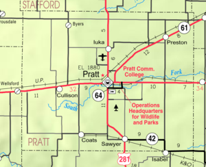
Geography
According to the 2000 census, the county has a total area of 735.76 square miles (1,905.6 km²), of which 734.99 square miles (1,903.6 km²) (or 99.90%) is land and 0.76 square miles (2 km²) (or 0.10%) is water.Adjacent counties
- Stafford CountyStafford County, KansasStafford County is a county located in the U.S. state of Kansas. As of the 2010 census, the county population was 4,437. Its county seat is St. John...
(north) - Reno CountyReno County, KansasReno County is a county located in the U.S. state of Kansas. The county's population was 64,511 for the 2010 census. The largest city and county seat is Hutchinson. The Hutchinson Micropolitan Statistical Area includes all of Reno County.-19th century:In 1887, the Chicago, Kansas and Nebraska...
(northeast) - Kingman CountyKingman County, KansasKingman County is a county located in the U.S. state of Kansas. As of the 2010 census, the county population was 7,858. The largest city and county seat is Kingman.-History:...
(east) - Barber CountyBarber County, KansasBarber County is a county located in South Central Kansas, in the Central United States. As of the 2010 census, the county population was 4,861. Its county seat and most populous city is Medicine Lodge...
(south) - Kiowa CountyKiowa County, KansasKiowa County is a county located in the U.S. state of Kansas. As of the 2010 census, the county population was 2,553...
(west) - Edwards CountyEdwards County, KansasEdwards County is a county located in Southwest Kansas, in the Central United States. As of the 2010 census, the county population was 3,037...
(northwest)
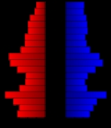
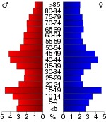
Demographics
Census
A census is the procedure of systematically acquiring and recording information about the members of a given population. It is a regularly occurring and official count of a particular population. The term is used mostly in connection with national population and housing censuses; other common...
of 2000, there were 9,647 people, 3,963 households, and 2,639 families residing in the county. The population density
Population density
Population density is a measurement of population per unit area or unit volume. It is frequently applied to living organisms, and particularly to humans...
was 13 people per square mile (5/km²). There were 4,633 housing units at an average density of 6 per square mile (2/km²). The racial makeup of the county was 95.28% White
Race (United States Census)
Race and ethnicity in the United States Census, as defined by the Federal Office of Management and Budget and the United States Census Bureau, are self-identification data items in which residents choose the race or races with which they most closely identify, and indicate whether or not they are...
, 0.98% Black
Race (United States Census)
Race and ethnicity in the United States Census, as defined by the Federal Office of Management and Budget and the United States Census Bureau, are self-identification data items in which residents choose the race or races with which they most closely identify, and indicate whether or not they are...
or African American
Race (United States Census)
Race and ethnicity in the United States Census, as defined by the Federal Office of Management and Budget and the United States Census Bureau, are self-identification data items in which residents choose the race or races with which they most closely identify, and indicate whether or not they are...
, 0.35% Native American
Race (United States Census)
Race and ethnicity in the United States Census, as defined by the Federal Office of Management and Budget and the United States Census Bureau, are self-identification data items in which residents choose the race or races with which they most closely identify, and indicate whether or not they are...
, 0.55% Asian
Race (United States Census)
Race and ethnicity in the United States Census, as defined by the Federal Office of Management and Budget and the United States Census Bureau, are self-identification data items in which residents choose the race or races with which they most closely identify, and indicate whether or not they are...
, 0.03% Pacific Islander
Race (United States Census)
Race and ethnicity in the United States Census, as defined by the Federal Office of Management and Budget and the United States Census Bureau, are self-identification data items in which residents choose the race or races with which they most closely identify, and indicate whether or not they are...
, 1.73% from other races
Race (United States Census)
Race and ethnicity in the United States Census, as defined by the Federal Office of Management and Budget and the United States Census Bureau, are self-identification data items in which residents choose the race or races with which they most closely identify, and indicate whether or not they are...
, and 1.07% from two or more races. 3.09% of the population were Hispanic
Race (United States Census)
Race and ethnicity in the United States Census, as defined by the Federal Office of Management and Budget and the United States Census Bureau, are self-identification data items in which residents choose the race or races with which they most closely identify, and indicate whether or not they are...
or Latino
Race (United States Census)
Race and ethnicity in the United States Census, as defined by the Federal Office of Management and Budget and the United States Census Bureau, are self-identification data items in which residents choose the race or races with which they most closely identify, and indicate whether or not they are...
of any race.
There were 3,963 households out of which 30.00% had children under the age of 18 living with them, 56.70% were married couples
Marriage
Marriage is a social union or legal contract between people that creates kinship. It is an institution in which interpersonal relationships, usually intimate and sexual, are acknowledged in a variety of ways, depending on the culture or subculture in which it is found...
living together, 7.50% had a female householder with no husband present, and 33.40% were non-families. 30.40% of all households were made up of individuals and 14.60% had someone living alone who was 65 years of age or older. The average household size was 2.35 and the average family size was 2.93.
In the county the population was spread out with 24.50% under the age of 18, 9.40% from 18 to 24, 24.00% from 25 to 44, 22.80% from 45 to 64, and 19.20% who were 65 years of age or older. The median age was 40 years. For every 100 females there were 94.00 males. For every 100 females age 18 and over, there were 91.30 males.
The median income for a household in the county was $35,529, and the median income for a family was $43,156. Males had a median income of $31,138 versus $20,679 for females. The per capita income
Per capita income
Per capita income or income per person is a measure of mean income within an economic aggregate, such as a country or city. It is calculated by taking a measure of all sources of income in the aggregate and dividing it by the total population...
for the county was $17,906. About 6.70% of families and 9.40% of the population were below the poverty line, including 11.50% of those under age 18 and 8.90% of those age 65 or over.
Incorporated cities
Name and population (2004 estimate):- PrattPratt, KansasPratt is a city in and the county seat of Pratt County in the U.S. state of Kansas. As of the 2010 census, the city population was 6,835. Pratt is home to Pratt Community College.-19th century:Pratt was founded in 1884 and named after Caleb S...
, 6,397 (county seat) - IukaIuka, KansasIuka is a city in Pratt County, Kansas, United States. As of the 2010 census, the city population was 163.-Geography:Iuka is located at . According to the United States Census Bureau, the city has a total area of , all of it land....
, 182 - PrestonPreston, KansasPreston is a city in Pratt County, Kansas, United States. As of the 2010 census, the city population was 158.-19th century:In 1887, the Chicago, Kansas and Nebraska Railway built a main line from Herington through Preston to Pratt. In 1888, this line was extended to Liberal. Later, it was...
, 161 - SawyerSawyer, KansasSawyer is a city in Pratt County, Kansas, United States. As of the 2010 census, the city population was 124.-Geography:Sawyer is located at . According to the United States Census Bureau, the city has a total area of , all of it land....
, 121 - CoatsCoats, KansasCoats is a city in Pratt County, Kansas, United States. As of the 2010 census, the city population was 83.-Geography:Coats is located at . According to the United States Census Bureau, the city has a total area of , all of it land....
, 110 - CullisonCullison, KansasCullison is a city in Pratt County, Kansas, United States. As of the 2010 census, the city population was 101.-Geography:Cullison is located at . According to the United States Census Bureau, the city has a total area of , all of it land.-Demographics:As of the census of 2000, there were 98...
, 96 - ByersByers, KansasByers is a city in Pratt County, Kansas, United States. As of the 2010 census, the city population was 35.-Geography:Byers is located at . According to the United States Census Bureau, the city has a total area of , all of it land....
, 49
Townships
Pratt County is divided into seven townshipsCivil township
A civil township is a widely used unit of local government in the United States, subordinate to, and geographic divisions of, a county. Specific responsibilities and the degree of autonomy vary based on each state. Civil townships are distinct from survey townships, but in states that have both,...
. The city of Pratt
Pratt, Kansas
Pratt is a city in and the county seat of Pratt County in the U.S. state of Kansas. As of the 2010 census, the city population was 6,835. Pratt is home to Pratt Community College.-19th century:Pratt was founded in 1884 and named after Caleb S...
is considered governmentally independent and is excluded from the census figures for the townships. In the following table, the population center is the largest city (or cities) included in that township's population total, if it is of a significant size.
| Township | FIPS | Population center |
Population | Population density /km² (/sq mi) |
Land area km² (sq mi) | Water area km² (sq mi) | Water % | Geographic coordinates |
|---|---|---|---|---|---|---|---|---|
| Township No. 6 | 71223 | 565 | 1 (4) | 381 (147) | 1 (0) | 0.17% | 37°44′25"N 98°33′55"W | |
| Township No. 7 | 71228 | 366 | 3 (7) | 136 (52) | 0 (0) | 0.02% | 37°45′20"N 98°43′49"W | |
| Township No. 8 | 71233 | 181 | 1 (2) | 197 (76) | 0 (0) | 0 % | 37°47′3"N 98°53′42"W | |
| Township No. 9 | 71238 | 317 | 1 (2) | 379 (146) | 0 (0) | 0.05% | 37°37′59"N 98°54′7"W | |
| Township No. 10 | 71242 | 191 | 1 (3) | 188 (73) | 0 (0) | 0.01% | 37°30′45"N 98°52′17"W | |
| Township No. 11 | 71245 | 496 | 2 (5) | 281 (109) | 0 (0) | 0.06% | 37°30′44"N 98°38′21"W | |
| Township No. 12 | 71248 | 961 | 3 (8) | 321 (124) | 1 (0) | 0.19% | 37°37′44"N 98°40′52"W |
Education
Unified school districts
Further reading
- History of the State of Kansas; William G. Cutler; A.T. Andreas Publisher; 1883. (Online HTML eBook)
- Kansas : A Cyclopedia of State History, Embracing Events, Institutions, Industries, Counties, Cities, Towns, Prominent Persons, Etc; 3 Volumes; Frank W. Blackmar; Standard Publishing Co; 944 / 955 / 824 pages; 1912. (Volume1 - Download 54MB PDF eBook),(Volume2 - Download 53MB PDF eBook), (Volume3 - Download 33MB PDF eBook)
External links
OfficialGeneral county information
County Level Data
Maps
- Pratt County Map, KDOT
- Kansas Highway Map, KDOT
- Kansas Railroad Map, KDOT
- Kansas School District Boundary Map, KSDE