
South Wales Traverse
Encyclopedia
The South Wales Traverse is a long distance fell running
challenge across the mountains of South Wales
. It is a linear route of 118 kilometres (73.3 mi) taking in some 31 summits over 610 metres (2,001.3 ft) high, giving about 5000 metres (16,404.2 ft) of ascent. The aim is for participants to complete the route, on foot, within 24 hours. Runners may start at either end, but traditionally it is run from west to east, so that the prevailing wind is on the runner's back and much of the ascent is done during the first half of the route. The route takes in the mountain ranges of the Black Mountain
, Carmarthenshire Fans, Fforest Fawr
, Central Brecon Beacons
, and the Black Mountains
, across most of the Brecon Beacons National Park.
The Traverse is somewhat easier to complete than its English Lake District
equivalent, the Bob Graham Round
. However, far fewer runners have done so due to the relatively low numbers who have actually attempted it. The selection of summits that must be visited is somewhat arbitrary, they are merely over 610 metres (2,001.3 ft) high and no other rules appear to have been applied in selecting them. Some of the summits are really just bumps on the ridge and not really summits in their own right at all.
The fastest known crossing of the Traverse was by Mark Hartell in 1993. He completed the distance in 14 hours 42 minutes.
The challenge is sometimes incorrectly referred to as the "Brecon Beacons Traverse". This name really only refers to the section of the route from Storey Arms to Talybont
over the Central Beacons and is a challenging day out favoured by some hillwalkers.
Fell running
Fell running, also known as mountain running and hill running, is the sport of running and racing, off road, over upland country where the gradient climbed is a significant component of the difficulty...
challenge across the mountains of South Wales
South Wales
South Wales is an area of Wales bordered by England and the Bristol Channel to the east and south, and Mid Wales and West Wales to the north and west. The most densely populated region in the south-west of the United Kingdom, it is home to around 2.1 million people and includes the capital city of...
. It is a linear route of 118 kilometres (73.3 mi) taking in some 31 summits over 610 metres (2,001.3 ft) high, giving about 5000 metres (16,404.2 ft) of ascent. The aim is for participants to complete the route, on foot, within 24 hours. Runners may start at either end, but traditionally it is run from west to east, so that the prevailing wind is on the runner's back and much of the ascent is done during the first half of the route. The route takes in the mountain ranges of the Black Mountain
Black Mountain (range)
The Black Mountain is a mountain range in Mid and West Wales, straddling the county boundary between Carmarthenshire and Powys and forming the westernmost range of the Brecon Beacons National Park. Its highest point is Fan Brycheiniog at 802 metres or 2,631 ft. The Black Mountain also forms a part...
, Carmarthenshire Fans, Fforest Fawr
Fforest Fawr
Fforest Fawr is the name given to an extensive upland area in the county of Powys, Wales. Formerly known as the 'Great Forest of Brecknock' in English, it was a royal hunting area for several centuries but is now used primarily for sheep grazing, forestry, water catchment and recreation...
, Central Brecon Beacons
Brecon Beacons
The Brecon Beacons is a mountain range in South Wales. In a narrow sense, the name refers to the range of popular peaks south of Brecon, including South Wales' highest mountain, Pen y Fan, and which together form the central section of the Brecon Beacons National Park...
, and the Black Mountains
Black Mountains, Wales
The Black Mountains are a group of hills spread across parts of Powys and Monmouthshire in southeast Wales, and extending across the national border into Herefordshire, England. They are the easternmost of the four ranges of hills that comprise the Brecon Beacons National Park, and are frequently...
, across most of the Brecon Beacons National Park.
The Traverse is somewhat easier to complete than its English Lake District
Lake District
The Lake District, also commonly known as The Lakes or Lakeland, is a mountainous region in North West England. A popular holiday destination, it is famous not only for its lakes and its mountains but also for its associations with the early 19th century poetry and writings of William Wordsworth...
equivalent, the Bob Graham Round
Bob Graham Round
The Bob Graham Round is a circuit of 42 fells in the English Lake District, including the peaks of Skiddaw, Helvellyn, Scafell and Scafell Pike...
. However, far fewer runners have done so due to the relatively low numbers who have actually attempted it. The selection of summits that must be visited is somewhat arbitrary, they are merely over 610 metres (2,001.3 ft) high and no other rules appear to have been applied in selecting them. Some of the summits are really just bumps on the ridge and not really summits in their own right at all.
The fastest known crossing of the Traverse was by Mark Hartell in 1993. He completed the distance in 14 hours 42 minutes.
The challenge is sometimes incorrectly referred to as the "Brecon Beacons Traverse". This name really only refers to the section of the route from Storey Arms to Talybont
Talybont-on-Usk
Talybont-on-Usk is a village and community in Powys, Wales. It lies on both the River Usk and the Monmouthshire and Brecon Canal, and in 2003 won the title of 'Powys Village of the Year'...
over the Central Beacons and is a challenging day out favoured by some hillwalkers.
Route
Below is a list of the summits that must be visited starting at Pen Rhiw Wen/Herbert's Quarry, running west to East.| Summit | Grid reference | Altitude/m | |
|---|---|---|---|
| Pen Rhiw-wen - A4069 A4069 road The A4069 is an A road which connects Llandovery with Gwaun-Cae-Gurwen in Wales, UK.The route begins at the junction with the A474 at the north of Gwaun-Cae-Gurwen, and travels through Lower Brynamman and Brynamman. The route then crosses over the Black Mountain range of the Brecon Beacons and... |
SN 730184 | 495 | |
| 1 | Garreg Lwyd Garreg Lwyd (Black Mountain) Garreg Lwyd, also known as Moel Gornach, is a peak in the Black Mountain of the Brecon Beacons, South Wales. It is a subsidiary summit of Fan Brycheiniog.... |
SN 740179 | 616 |
| 2 | Garreg Las Garreg Las Garreg Las is a subsidiary summit of Fan Brycheiniog in the Brecon Beacons National Park in the county of Carmarthenshire, south Wales. Its summit sits towards the northern end of a broad north-south ridge, Esgair Hir , at above sea level... |
SN 777203 | 635 |
| 3 | Bannau Sir Gaer | SN 811218 | 749 |
| 4 | Fan Brycheiniog Fan Brycheiniog Fan Brycheiniog is the highest peak in the Black Mountain region of the Brecon Beacons National Park in South Wales. It is just inside the county of Powys, and also within the Fforest Fawr Geopark designated in 2005 in recognition of the area's geological heritage.The Beacons Way, a waymarked long... |
SN 825218 | 802 |
| 5 | Fan Hir Fan Hir Fan Hir is a peak at the eastern end of the Black Mountain in the Brecon Beacons National Park in south Wales. It is a subsidiary summit of Fan Brycheiniog. It falls within the county of Powys and is also a part of the traditional area of Fforest Fawr... |
SN 830209 | 761 |
| Trecastell Trecastle Trecastle is a village in Powys, Wales, on the edge of the Brecon Beacons National Park.Trecastle is named after an early 12th century motte-and-bailey fortification , built by Bernard de Neufmarche and designed to protect Brecon from attack from the west... road |
SN 853203 | 369 | |
| A4067 | SN 870195 | 387 | |
| 6 | Fan Gyhirych Fan Gyhirych Fan Gyhirych is a mountain in the Fforest Fawr section of Brecon Beacons National Park in south Wales. It lies within the county of Powys, formerly Brecknockshire.... |
SN 880190 | 725 |
| 7 | Fan Nedd Fan Nedd Fan Nedd is a mountain in the Fforest Fawr area of the Brecon Beacons National Park in Wales. In common with the rest of the Fforest Fawr uplands it is within the county of Powys.... |
SN 913184 | 663 |
| Sarn Helen Sarn Helen right|thumb|250px|A section of Sarn Helen near Betws-y-coed.Sarn Helen was a Roman road in Wales, running from Aberconwy in the north to Carmarthen in the south.It was some 160 miles in length... /minor road junction |
SN 925185 | 400 | |
| 8 | Fan Llia Fan Llia Fan Llia is a subsidiary summit of Fan Fawr in the Fforest Fawr section of the Brecon Beacons National Park, Wales. In common with other peaks in the Fforest Fawr uplands it lies within the county of Powys.... |
SN 938186 | 632 |
| 9 | Fan Frynych Fan Frynych Fan Frynych is a subsidiary summit of Fan Fawr in the Fforest Fawr section of the Brecon Beacons National Park, South Wales. It makes up half of the Craig Cerrig-gleisiad and Fan Frynych National Nature Reserve with its sister peak Craig Cerrig-gleisiad.... |
SN 957227 | 629 |
| 10 | Rhos Dringarth (Craig Cerrig-gleisiad Craig Cerrig-gleisiad Craig Cerrig-gleisiad is a subsidiary summit of Fan Fawr in the Fforest Fawr section of the Brecon Beacons National Park, South Wales. It makes up half of the Craig Cerrig-gleisiad and Fan Frynych National Nature Reserve with its sister peak Fan Frynych.... ) |
SN 960217 | 629 |
| 11 | Fan Fawr Fan Fawr Fan Fawr is a mountain in the Fforest Fawr section of the Brecon Beacons National Park, South Wales and over 734 m high.... |
SN 969193 | 734 |
| Storey Arms | SN 983203 | 445 | |
| 12 | Y Gyrn Y Gyrn Y Gyrn is a top of Pen y Fan in South Wales, situated in the Brecon Beacons National Park. Tommy Jones' Obelisk is found in between the summit and Corn Du.... |
SN 988215 | 619 |
| 13 | Duwynt | SO 005207 | 824 |
| 14 | Corn Du Corn Du Corn Du is a mountain immediately to the southwest of Pen y Fan and the second highest peak in South Wales, situated in the Brecon Beacons National Park. Tommy Jones' Obelisk is found on its western flanks, in between the summit and Y Gyrn.... |
SO 007213 | 873 |
| 15 | Pen y Fan Pen y Fan Pen y Fan is the highest peak in South Wales and southern Britain, situated in the Brecon Beacons National Park. At above sea-level, it is also the highest peak in Britain south of the Snowdonia mountain range... |
SO 012215 | 886 |
| 16 | Cribyn Cribyn (hill) Cribyn is a mountain in the Brecon Beacons with an elevation of 795 metres.The summit lies on a ridge stretching from Talybont Reservoir in the east, to the A470 road. The ridge line to the west connects Cribyn with the peak of Pen y Fan... |
SO 023213 | 795 |
| 17 | Waun Rydd Waun Rydd Waun Rydd is a mountain in the Brecon Beacons National Park, in southern Powys, Wales. Its height is 769m and it tops a large boggy plateau rising to the east of Pen y Fan.... |
SO 062205 | 769 |
| 18 | Allt Lwyd Allt Lwyd Allt Lwyd is a top of Waun Rydd in the Brecon Beacons National Park, in southern Powys, Wales.The summit is heathery and marked by a small pile of stones. It is found at the end of Waun Rydd's south-east ridge. It overlooks Talybont Reservoir, and has the Talybont Forest on its steep... |
SO 078189 | 654 |
| Abercynafon | SO 083177 | 212 | |
| 19 | Cefn yr Ystrad Cefn yr Ystrad Cefn yr Ystrad is a mountain in the Brecon Beacons National Park in Wales. It is an outlier of the Central Beacons group.The broad northeast - southwest aligned ridge reaches an elevation of 617 metres. One of the southernmost peaks in the Brecon Beacons, it rises to the east of Pontsticill Reservoir... |
SO 086137 | 607 |
| Pyrgad | SO 101159 | 260 | |
| Llangynidr Llangynidr Llangynidr is a village in Powys, Wales, about west of Crickhowell and south-east of Brecon. The River Usk flows through the village as does the Monmouthshire and Brecon Canal on which there are four locks.... - Red Lion |
SO 155194 | 127 | |
| Cwm-gu | SO 200209 | 190 | |
| 20 | Pen Cerrig-calch Pen Cerrig-Calch Pen Cerrig-calch is a subsidiary summit of Waun Fach in the Black Mountains in the Brecon Beacons National Park in southern Powys, Wales. Its summit, at a height of 701m , is marked by a trig point... |
SO 217223 | 701 |
| 21 | Pen Allt-mawr Pen Allt-mawr Pen Allt-mawr is subsidiary summit of Waun Fach and the third highest peak in the Black Mountains in south-eastern Wales. It lies near the end of the westernmost of Waun Fach's south ridges. It is a very recognisable and prominent peak of the Black Mountains.It summit is stony and has a large... |
SO 206243 | 719 |
| 22 | Mynydd Llysiau Mynydd Llysiau Mynydd Llysiau is a subsidiary summit of Waun Fach in the Black Mountains in south-eastern Wales. It lies halfway between Waun Fach and Pen Allt-mawr. It is a distinguished summit with a steep eastern face.... |
SO 207279 | 663 |
| 23 | Waun Fach Waun Fach Waun Fach is the highest mountain in the Black Mountains in south-eastern Wales. It is one of the three Marilyns over 600m that make up the range, the others being Black Mountain and Mynydd Troed. To the north Rhos Fawr and the Radnor Forest can be seen.It is situated at the head of the Grwyne... |
SO 215299 | 811 |
| 24 | Pen y Gadair Fawr Pen y Gadair Fawr Pen y Gadair Fawr is a subsidiary summit of Waun Fach and the second highest peak in the Black Mountains in south-eastern Wales. Pen y Gadair Fawr is a much more distinguished top than its parent.... |
SO 229287 | 800 |
| 25 | Pen Twyn Mawr Pen Twyn Mawr Pen Twyn Mawr is a top of Pen y Gadair Fawr in the Black Mountains in south-eastern Wales. It lies on one of the many south ridges of Waun Fach.... |
SO 242267 | 658 |
| Grwyne Fawr Grwyne Fawr The Grwyne Fawr is a river in the Brecon Beacons National Park in south Wales. A section of it forms the administrative border between Powys and Monmouthshire and also of the historic counties of Brecon and Monmouth. The river and its major tributary the Grwyne Fechan flow into the River Usk at... (minor road) |
SO 252285 | 407 | |
| 26 | Chwarel y Fan Chwarel y Fan Chwarel y Fan is a peak in the Black Mountains in south-eastern Wales. It is the highest rise on the long ridge which extends southeastwards from Rhos Dirion. The ridge continues southeastwards to the lesser summit of Bal-Mawr whose top is adorned by a trig point at 607m above sea level.The summit... |
SO 258294 | 670 |
| 27 | Rhos Dirion Rhos Dirion Rhos Dirion is a top of Waun Fach in the Black Mountains in south-eastern Wales. It is the highest point on the Rhos Dirion - Chwarel y Fan ridge.... |
SO 211334 | 713 |
| 28 | Twmpa Twmpa Twmpa or Lord Hereford's Knob is a mountain in south-east Wales, forming a part of the great northwest scarp of the Black Mountains. It lies 3 km west of the border with England, and around 7 km south of Hay-on-Wye. To the northeast lies the Gospel Pass through which runs a minor road... |
SO 224350 | 690 |
| Gospel Pass | SO 235352 | 550 | |
| 29 | Hay Bluff | SO 244366 | 677 |
| 30 | Black Mountain Black Mountain (hill) Twyn Llech also known as Black Mountain is a mountain in the Black Mountains . It is the only Marilyn to fall exactly on the Welsh-English border, straddling Powys and Herefordshire... |
SO 255350 | 703 |
| 31 | Pen y Garn Fawr | SO 277311 | 616 |
| Llanthony Priory Llanthony Priory Llanthony Priory is a partly ruined former Augustinian priory in the secluded Vale of Ewyas, a steep sided once glaciated valley within the Black Mountains area of the Brecon Beacons National Park in Monmouthshire, south east Wales. It lies seven miles north of Abergavenny on an old road to Hay... 51.943°N 3.038°W |
SO 287279 | 241 | |
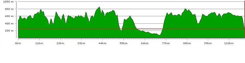
Route profile
Below is a profile of the route, again starting at Pen Rhiw Wen/Herbert's Quarry, running west to East.See also
- http://www.mdcwales.org.uk/Newsletter/Newsletter_2005/mdcnewsjuly2005.pdf - Mynyddwyr De Cymru newsletter article on a group traverse – page 4