

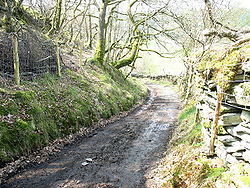
Sarn Helen
Encyclopedia
Roman roads in Britain
Roman roads, together with Roman aqueducts and the vast standing Roman army , constituted the three most impressive features of the Roman Empire. In Britain, as in other provinces, the Romans constructed a comprehensive network of paved trunk roads Roman roads, together with Roman aqueducts and the...
in Wales
Roman Wales
The history of Wales in the Roman era began in AD 48 with a military invasion by the imperial governor of Roman Britain. The conquest would be completed by 78, and Roman rule would endure until the region was abandoned in 383 AD...
, running from Aberconwy
Aberconwy (district)
The Borough of Aberconwy was one of five districts of Gwynedd, north-west Wales, from 1974 to 1996.It was formed under the Local Government Act 1972, on April 1, 1974 from parts of the administrative counties of Caernarfonshire and Denbighshire....
in the north
North Wales
North Wales is the northernmost unofficial region of Wales. It is bordered to the south by the counties of Ceredigion and Powys in Mid Wales and to the east by the counties of Shropshire in the West Midlands and Cheshire in North West England...
to Carmarthen
Carmarthen
Carmarthen is a community in, and the county town of, Carmarthenshire, Wales. It is sited on the River Towy north of its mouth at Carmarthen Bay. In 2001, the population was 14,648....
in the south.
It was some 160 miles in length. Today some sections are modern highways, others still traceable as Roman though much degraded, and at various places there is much debate as to where the road ran.
Route
In the north the route is believed to follow the western bank of the river ConwyRiver Conwy
The River Conwy is a river in north Wales. From its source to its discharge in Conwy Bay it is a little over long. "Conwy" is sometimes Anglicized as "Conway."...
from Canovium
Canovium
Canovium was a fort in the Roman province of Britannia. Its site is located at Caerhun in the Conwy valley, in the county borough of Conwy, in North Wales....
, a fort at Caerhun
Caerhun
Caerhun is a village and rural community on the west bank of the River Conwy, to the south of Henryd and to the north of Dolgarrog, in Conwy County Borough, north Wales. The population was 1200 at the 2001 Census.-Features:...
, passing through Trefriw
Trefriw
Trefriw is a village in Conwy County Borough, Wales. It lies on the river Conwy in North Wales, a few miles south of the site of the Roman fort of Canovium, sited at Caerhun. The parish population in 2001 was 924....
, then leading on to Betws y Coed, with a branch leading to Caer Llugwy
Caer Llugwy
Caer Llugwy, or Bryn-y-Gefeiliau, is the site of a Roman fort in a loop of the Afon Llugwy near Capel Curig in Conwy, Wales. It is notable in that there has been little development in the surrounding landscape: the valley in which it is situated being much as it was 2000 years ago. It is a...
near Capel Curig
Capel Curig
Capel Curig is a village and community in Conwy County Borough, in Wales. It lies in the heart of Snowdonia, on the River Llugwy, and has a population of 226...
. The route then passed through Dolwyddelan
Dolwyddelan
Dolwyddelan, Welsh language : 'the meadow of Gwyddelan', is a village and community in Conwy county borough, north Wales, on the main A470 road between Blaenau Ffestiniog and Betws-y-Coed...
, running up Cwm Penanmen and past the higher parts of Cwm Penmachno
Cwm Penmachno
Cwm Penmachno is a former quarry settlement at the head of the Penmachno valley in North Wales. The slate quarry was formerly linked by narrow-gauge railway to the Ffestiniog railway at Blaenau Ffestiniog...
. The route then leads on past Llan Ffestiniog
Llan Ffestiniog
Llan Ffestiniog, also known as Ffestiniog or simply Llan is a village in Gwynedd , north Wales, lying south of Blaenau Ffestiniog....
to the Roman fort of Tomen y Mur
Tomen y Mur
Tomen y Mur is a Roman fort complex in Gwynedd, Wales. The fort was constructed under governor Gnaeus Julius Agricola in AD 78, and was abandoned around AD 140. A millennium later, in the Norman period, the site was reoccupied and refortified with a motte within the old walls...
, near Trawsfynydd
Trawsfynydd
Trawsfynydd is a village in Gwynedd, North Wales, adjacent to the A470 north of Dolgellau near Blaenau Ffestiniog....
before continuing south towards Dolgellau
Dolgellau
Dolgellau is a market town in Gwynedd, north-west Wales, lying on the River Wnion, a tributary of the River Mawddach. It was the county town of the former county of Merionethshire .-History and economy:...
.
South of Dolgellau the route passes over Waen Llefenni into Cwm yr Hengae to Aberllefenni
Aberllefenni
Aberllefenni is a village in the south of Gwynedd, Wales. It lies in the valley of the Afon Dulas.Part of the ancient county of Merionethshire, it is the location of Foel Grochan, a slate quarry which together with Hen Chwarel and Ceunant Ddu formed the Aberllefenni Slate Quarry, which extracted...
. Part of the narrow-gauge Corris Railway
Corris Railway
The Corris Railway is a narrow gauge preserved railway based in Corris on the border between Merionethshire and Montgomeryshire in Mid-Wales....
between Aberllefenni and Maespoeth Junction
Maespoeth Junction
Maespoeth Junction lies to the south of Corris in Gwynedd and was where the horse-hauled tramway from the slate quarries around Corris Uchaf met the main line of the Corris Railway coming from Aberllefenni...
may run along the line of the Sarn, and the modern A487 trunk road between Corris
Corris
Corris is a village in the south of Snowdonia in the Welsh county of Gwynedd. Although the Snowdonia National Park covers much of the area around Corris, the village is not within the park. The name is possibly derived from the English word "quarries", and the extensive slate quarries that surround...
and the Afon Dyfi may follow its route. It probably crossed the Dyfi by a ford or ferry near the Roman fort at Pennal
Pennal
Pennal is a village on the A493 road in southern Gwynedd, Wales, on the north bank of the Afon Dyfi/River Dovey, near Machynlleth.It lies in the former county of Merionethshire/Sir Feirionnydd, and is within the Snowdonia National Park.-Roman Fort:...
.
In Ceredigion
Ceredigion
Ceredigion is a county and former kingdom in mid-west Wales. As Cardiganshire , it was created in 1282, and was reconstituted as a county under that name in 1996, reverting to Ceredigion a day later...
Sarn Helen runs as part of a B-road in Bronant, and six miles south there is a long stretch through the hamlet of Stag's Head. It passes down to Llanio where there was a small Roman fort named Bremia
Bremia
Bremia is the name of the Roman fort in Llanio, West Wales. The fort was used by the Romans between AD 75 to AD 120 in Roman Wales. The fort was situated on Sarn Helen , a Roman road leading north from the fort at Dolaucothi. It has produced an inscription dedicated to a cohort from the Asturias,...
, and crosses over to Dolaucothi before reaching Llandovery
Llandovery
Llandovery is a market town in Carmarthenshire, Wales, lying on the River Tywi and the A40 road.The town is served by Llandovery railway station, where there is a park and ride to Llanelli and Shrewsbury via the Heart of Wales Line...
. The route survives as a minor road here, although severely affected by potholes where it crosses the mountains.
A further section of Roman road leading north-eastwards from Neath
Neath
Neath is a town and community situated in the principal area of Neath Port Talbot, Wales, UK with a population of approximately 45,898 in 2001...
(Roman 'NIDVM') to Banwen
Banwen
Banwen is a small village in Neath Port Talbot county borough in Wales. Banwen is part of the community of Onllwyn along with the village of Onllwyn itself and the adjacent parish of Dyffryn Cellwen...
at the southern edge of the Brecon Beacons National Park is known as Sarn Helen. It continues north-eastwards through the Park to the north-west of Ystradfellte
Ystradfellte
Ystradfellte is a small village in Powys, Wales, in the Fforest Fawr area of the Brecon Beacons National Park.Because of the geography and topography of the area the village of Ystradfellte is not visible from the nearest main road, the A4059 Hirwaun to A470 stretch.Ystradfellte comes under...
, beneath Fan Frynych
Fan Frynych
Fan Frynych is a subsidiary summit of Fan Fawr in the Fforest Fawr section of the Brecon Beacons National Park, South Wales. It makes up half of the Craig Cerrig-gleisiad and Fan Frynych National Nature Reserve with its sister peak Craig Cerrig-gleisiad....
and then across Mynydd Illtud
Mynydd Illtud
Mynydd Illtud is an extensive area of common land three miles south-east of Brecon in the Brecon Beacons National Park in the county of Powys, Wales. The common is an undulating plateau lying between above sea level...
en route to the Roman fort of Y Gaer, Brecon
Y Gaer, Brecon
Y Gaer, Brecon is a Roman fort situated near modern day Brecon in Mid Wales, United Kingdom.Y Gaer is located at .- History :...
(Roman 'CICVCIVM').
The Sarn Helen Trail
The Sarn Helen Trail is a long-distance mountain bike route. Devised by Tim Woodcock in 1996, it runs for 270 miles from Conwy on the North Wales coast to Worms Head in the south. A book, detailing the route, was first published by MBRUK (Mountain Bike Routes UK) in 1998.In Popular Culture
"Sarn Helen" is also the title of a song by WelshWales
Wales is a country that is part of the United Kingdom and the island of Great Britain, bordered by England to its east and the Atlantic Ocean and Irish Sea to its west. It has a population of three million, and a total area of 20,779 km²...
band Super Furry Animals
Super Furry Animals
Super Furry Animals are a Welsh rock band that lean towards psychedelic rock and electronic experimentation. Since their formation in Cardiff, Wales in 1993, the band has consisted of Gruff Rhys , Huw Bunford , Guto Pryce , Cian Ciaran and Dafydd Ieuan Super Furry Animals are a Welsh rock band...
, named after the Roman road
Roman road
The Roman roads were a vital part of the development of the Roman state, from about 500 BC through the expansion during the Roman Republic and the Roman Empire. Roman roads enabled the Romans to move armies and trade goods and to communicate. The Roman road system spanned more than 400,000 km...
, appearing on their Welsh language
Welsh language
Welsh is a member of the Brythonic branch of the Celtic languages spoken natively in Wales, by some along the Welsh border in England, and in Y Wladfa...
album Mwng
Mwng
Mwng is the fourth studio album by Welsh rock band the Super Furry Animals, and the first by the group to have lyrics written entirely in the Welsh language. Mwng was released on 15 May 2000 on the band's own record label, Placid Casual, following the demise of their former label Creation...
.