
South Cross Route
Encyclopedia
South Cross Route was the designation for the southern section of Ringway 1
, the innermost circuit of the London Ringways
network, a complex and comprehensive plan for a network of high speed roads circling and radiating out from central London
designed to manage and control the flow of traffic within the capital.
The SCR was planned during the late 1960s along with the rest of the Ringway scheme but was never constructed due to large scale opposition from many quarters. The construction work required to pass a six-lane dual carriageway
with grade separated junctions through the congested streets of south London would have been enormous and devastating to the communities through which it passed. In November 2011, Mayor of London Boris Johnson
announced that he will start a public enquiry regarding whether to build this route as a direct consequence of over-congestion on the A23 and lack of trunk roads from Central London through South London to Gatwick Airport.
coming south-east across the River Thames
from Earl's Court. The junction was planned to be located on the triangle of land between the railway lines around Falcon Park and crossing Latchmere Road (A3220
). The junction would also have had a connection westwards to a feeder motorway to the planned terminus of the M3 motorway
and the actual terminus of the M4 motorway
at Gunnersbury
. It is possible that this motorway would have been designated as a continuation of the M4.
Heading east the SCR would have followed the route of the National Rail
main line to Waterloo
crossing the tracks south-west of Queenstown Road
station. Here the SCR would have had a junction with Queenstown Road (A3216) and passed over the railway and industrial land there to head south-east towards Heathbrook Park and Wandsworth Road
station. The SCR would then have followed the south side of the line, requiring the demolition of most of the east side of Edgeley Road, then past Clapham High Street
station to a junction with Clapham High Street (A3
).
Continuing east, the SCR would have claimed much of the north side of Ferndale Road as well as most, if not all, of Dolman, Glendall and Bythorn Streets, three short cul-de-sac
s between Ferndale Road and the railway tracks. The SCR would have next reached a difficult section through Brixton
town centre where a complexity of railway tracks branching and crossing above one another to follow different routes, Brixton
station and the narrow shopping streets would have needed considerable demolition to make a route for the elevated SCR. In conjunction with the road scheme, the Greater London Council
proposed a scheme for the almost total clearance and reconstruction of the town centre including the construction of more than a dozen 50-storey blocks of flats as well as widespread low-rise residential and commercial projects. Just as the road itself attracted objections, the redevelopment of the town centre met with considerable local opposition and virtually none of the proposals were implemented.
East of Brixton Road (A23
), the SCR would have followed Coldharbour Lane
and passed the north side of the Moorland Estate where the council block on the north side, Southwyck House, is a relic of the GLC redevelopment scheme and was designed to present a barrier to protect the estate beyond from the noise of the elevated motorway.
Crossing the southbound railway line from Blackfriars station
, the SCR would have continued east, requiring further demolitions on the south side of the Loughborough Junction
triangle to reach Ruskin Park. East of Ruskin Park the SCR would have passed along Champion Park between Denmark Hill
station and the Salvation Army
's William Booth College.
East of Denmark Hill station the south side of the railway line to the next station at Peckham Rye
was, in the late 1960s, a relatively wide and clear embankment and would have provided the space for another road junction, connecting either to Grove Lane or possibly across the railway to Peckham Road via Vestry Road and Lucas Gardens. In recent years a number of residential developments have been constructed in this area.
For its route through Peckham the SCR would have claimed Blenheim Grove on the south side of the station and more industrial land to its east before following the railway to Nunhead
station on an alignment where the wide area of railway land to the south of the tracks would have provided a route requiring only limited demolition, mainly to the north side of Kimberley Avenue. To the east of Nunhead station, the SCR would have crossed two further sets of railway tracks - one branching south-east to Crofton Park
and the other the line between New Cross Gate
and Brockley
stations. Again, when the SCR was planned, this section was an uninterrupted alignment for the motorway to follow but it has since been developed with residential infill schemes.
East of the New Cross Gate railway tracks the railway land continues to be wide enough for the SCR to have passed with only limited demolition works required as it headed towards Lewisham
town centre. At Lewisham the SCR would have merged with a spur from the north-west that was planned to run 0.75 miles along the New Cross
railway line to end at a junction on New Cross Road (A2
). The SCR would have crossed to the north side of the railway to skirt the town centre passing through industrial and commercial areas and crossing over the route now occupied by the Docklands Light Railway
. Residential demolitions would have been required at the west end of Granville Park to clear the path but the route was then clear to Blackheath
station.
East of Blackheath station the SCR looped south-east to follow the railway line through the north side of Blackheath Park
, where some demolitions would have been necessary, before skirting the sports ground and Kidbrooke
station to meet the junction of the East Cross Route
coming south from the Blackwall Tunnel
, the A2 Rochester Way Relief Road coming east from Eltham
and the A20 coming north from Mottingham
.
This junction, the south-east corner of the London Motorway Box
, would not have provided traffic movements in all directions. it is probable that SCR traffic would have been directed onto to the A2 or A20 and would not have been able to access the East Cross Route northbound.
running through south London. Other incoming motorways, such as the M1
and M11
, were intended to terminate directly on the innermost Ringway, but the route of the M23 through south London was considerably more difficult than the M1's route through north London and there was no simple or direct route for the M23 to reach Ringway 1 in Clapham. Instead, the Balham Loop would have acted as a distributor road connecting to the West Cross Route and SCR at Battersea and to the SCR at Brixton, via the "South Cross Route to Parkway D Radial".
Leaving the junction of the West Cross Route and SCR heading south-west, the Balham Loop would have passed over the railway land at Clapham Junction station before heading south to cross the A3 at Battersea Rise then run parallel with the railway across Wandsworth Common
to cross Nightingale Lane (B229) and past Wandsworth Common
station.
It is not certain which side of the railway the motorway would have run but the south side of the railway through Balham
is likely to have offered the road planners the easier route. At Tooting Common
the Balham Loop would have had a Y-shaped junction with the end of the M23 motorway
coming north from Streatham Vale and would then have continued through Streatham Hill, over the A23 and then would have cut through a residential area to reach the triangular railway junction south of Tulse Hill
station. Here the Balham Loop would have met the "South Cross Route to Parkway D Radial" motorway and traffic would have had the option of turning north-east towards Brixton or south-east to West Norwood
.
The Balham Loop was cancelled in 1967 when it was decided that the M23 would be terminated further south on Ringway 2
at Streatham Vale.
. The route was an early omission from the developing Ringways plans and the alignment in the outer suburbs is uncertain. The cumbersome name reflects the reuse of an earlier route proposal from Sir Patrick Abercrombie's
County of London Plan
, 1943. The Ringway plan's Ringway 3 equated to Parkway D from Abercrombie's plan. The use of the obsolete terminology suggests that the planning for this road was not a top priority for the road planners.
From the SCR the radial motorway would have first followed the railway line south-east past Herne Hill and Brockwell Park
to Tulse Hill, West Norwood and Crystal Palace
station where it would have turned and headed south along the line towards South Norwood Country Park
, which in the 1960s was a sewage works
. From here the route is uncertain but it would have probably crossed Addiscombe
and Shirley
to reach Addington and Ringway 3.
The SCR and the other roads planned in the 1960s for central London had developed from early schemes prior to the Second World War through Sir Patrick Abercrombie's County of London Plan, 1943 and Greater London Plan, 1944 to a 1960s Greater London Council
(GLC) scheme that would have involved the construction of many miles of motorway standard roads across the city and demolition on a massive scale. Due to the huge construction costs and widespread public opposition, most of the scheme including the SCR was cancelled in 1973. Only the East Cross Route, part of the West Cross Route and the Westway
were built.
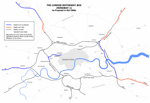
Ringway 1
Ringway 1 or the London Motorway Box was the innermost of the series of four motorway standard roads, known as the London Ringways as part of a comprehensive scheme developed by the Greater London Council to provide high speed motorway-standard roads within the capital linking a series of radial...
, the innermost circuit of the London Ringways
London Ringways
The London Ringways were a series of four ring roads planned in the 1960s to circle London at various distances from the city centre. They were part of a comprehensive scheme developed by the Greater London Council to alleviate traffic congestion on the city's road system by providing high speed...
network, a complex and comprehensive plan for a network of high speed roads circling and radiating out from central London
London
London is the capital city of :England and the :United Kingdom, the largest metropolitan area in the United Kingdom, and the largest urban zone in the European Union by most measures. Located on the River Thames, London has been a major settlement for two millennia, its history going back to its...
designed to manage and control the flow of traffic within the capital.
The SCR was planned during the late 1960s along with the rest of the Ringway scheme but was never constructed due to large scale opposition from many quarters. The construction work required to pass a six-lane dual carriageway
Dual carriageway
A dual carriageway is a class of highway with two carriageways for traffic travelling in opposite directions separated by a central reservation...
with grade separated junctions through the congested streets of south London would have been enormous and devastating to the communities through which it passed. In November 2011, Mayor of London Boris Johnson
Boris Johnson
Alexander Boris de Pfeffel Johnson is a British journalist and Conservative Party politician, who has been the elected Mayor of London since 2008...
announced that he will start a public enquiry regarding whether to build this route as a direct consequence of over-congestion on the A23 and lack of trunk roads from Central London through South London to Gatwick Airport.
Route
The SCR would have started in Battersea at the south-west corner of Ringway 1 where it would have had a junction with the West Cross RouteWest Cross Route
The West Cross Route is a short, dual carriageway section of the A3220 route in central London in The Royal Borough of Kensington and Chelsea, with a small part being shared with borderlining borough Hammersmith and Fulham. It runs north-south between the northern elevated roundabout junction...
coming south-east across the River Thames
River Thames
The River Thames flows through southern England. It is the longest river entirely in England and the second longest in the United Kingdom. While it is best known because its lower reaches flow through central London, the river flows alongside several other towns and cities, including Oxford,...
from Earl's Court. The junction was planned to be located on the triangle of land between the railway lines around Falcon Park and crossing Latchmere Road (A3220
A3220 road
The A3220 is a primary A road in London. It runs north from Clapham Common to the A40 Westway at Ladbroke Grove.The road crosses the River Thames at Battersea Bridge and from this point until its end it forms the western boundary of the London Congestion Charge zone...
). The junction would also have had a connection westwards to a feeder motorway to the planned terminus of the M3 motorway
M3 motorway
The M3 motorway runs in England for approximately from Sunbury-on-Thames, Surrey, to Southampton, Hampshire and forms an unsigned section European route E05. It is dual three lanes as far as Junction 8 near Basingstoke and then dual two lane until Junction 9 near Winchester and then dual three...
and the actual terminus of the M4 motorway
M4 motorway
The M4 motorway links London with South Wales. It is part of the unsigned European route E30. Other major places directly accessible from M4 junctions are Reading, Swindon, Bristol, Newport, Cardiff and Swansea...
at Gunnersbury
Gunnersbury
Gunnersbury is a place in the London Borough of Hounslow, with its northern edge in the London Borough of Ealing, west London. It has an area of less than half a square kilometre and is within the west area of the Chiswick W4 postal district of London....
. It is possible that this motorway would have been designated as a continuation of the M4.
- In the mid-1960s the Ringways plan also included a motorway, known as the Balham Loop, heading south-west from the triangular junction through Clapham JunctionClapham Junction railway stationClapham Junction railway station is near St John's Hill in the south-west of Battersea in the London Borough of Wandsworth. Although it is in Battersea, the area around the station is commonly identified as Clapham Junction....
station, then south towards BalhamBalhamBalham is a district of London, EnglandBalham can also refer to:*Balham, Ardennes, a commune in France*Balham station, railway and tube station in Balham, London*Balaam, a Biblical figure...
and east to Tulse HillTulse HillTulse Hill is a district in the London Borough of Lambeth in South London, England. It lies to the south of Brixton, east of Brixton Hill, north of West Norwood and west of West Dulwich.-History:...
. This route was omitted from the plans in 1967.
Heading east the SCR would have followed the route of the National Rail
National Rail
National Rail is a title used by the Association of Train Operating Companies as a generic term to define the passenger rail services operated in Great Britain...
main line to Waterloo
Waterloo station
Waterloo station, also known as London Waterloo, is a central London railway terminus and London Underground complex. The station is owned and operated by Network Rail and is close to the South Bank of the River Thames, and in Travelcard Zone 1....
crossing the tracks south-west of Queenstown Road
Queenstown Road (Battersea) railway station
Queenstown Road is a railway station in South London, between Vauxhall and Clapham Junction. It is a short walk from Battersea Park station and Battersea Park...
station. Here the SCR would have had a junction with Queenstown Road (A3216) and passed over the railway and industrial land there to head south-east towards Heathbrook Park and Wandsworth Road
Wandsworth Road railway station
Wandsworth Road railway station is on the South London Line from London Victoria to .It is operated by Southern. The next stations are to the west, towards Victoria and to the east, towards London Bridge.-History:...
station. The SCR would then have followed the south side of the line, requiring the demolition of most of the east side of Edgeley Road, then past Clapham High Street
Clapham High Street railway station
Clapham High Street railway station is on the South London Line from London Victoria to .It is close to station and interchange between the two is counted as an Out of Station Interchange on Oyster, so journeys involving a change between the two are charged as through journeys and not two...
station to a junction with Clapham High Street (A3
A3 road
The A3, known as the Portsmouth Road for much of its length, is a dual carriageway, or expressway, which follows the historic route between London and Portsmouth passing close to Kingston upon Thames, Guildford, Haslemere and Petersfield. For much of its length, it is classified as a trunk road...
).
Continuing east, the SCR would have claimed much of the north side of Ferndale Road as well as most, if not all, of Dolman, Glendall and Bythorn Streets, three short cul-de-sac
Cul-de-sac
A cul-de-sac is a word of French origin referring to a dead end, close, no through road or court meaning dead-end street with only one inlet/outlet...
s between Ferndale Road and the railway tracks. The SCR would have next reached a difficult section through Brixton
Brixton
Brixton is a district in the London Borough of Lambeth in south London, England. It is south south-east of Charing Cross. The area is identified in the London Plan as one of 35 major centres in Greater London....
town centre where a complexity of railway tracks branching and crossing above one another to follow different routes, Brixton
Brixton railway station
Brixton Railway Station is a commuter railway station in the centre of Brixton, inSouth London, UK. It is on the Chatham Main Line which runs from London Victoria to Orpington. Trains are operated by Southeastern. The typical service is one train every 15 minutes in both directions.Brixton Railway...
station and the narrow shopping streets would have needed considerable demolition to make a route for the elevated SCR. In conjunction with the road scheme, the Greater London Council
Greater London Council
The Greater London Council was the top-tier local government administrative body for Greater London from 1965 to 1986. It replaced the earlier London County Council which had covered a much smaller area...
proposed a scheme for the almost total clearance and reconstruction of the town centre including the construction of more than a dozen 50-storey blocks of flats as well as widespread low-rise residential and commercial projects. Just as the road itself attracted objections, the redevelopment of the town centre met with considerable local opposition and virtually none of the proposals were implemented.
- For a while, the destruction planned for Brixton town centre would have been even greater. It was intended to locate a junction here to connect the SCR to a motorway running south-east along the railway line to Herne HillHerne HillHerne Hill is located in the London Borough of Lambeth and the London Borough of Southwark in Greater London. There is a road of the same name which continues the A215 north of Norwood Road and was called Herne Hill Road.-History:...
and then to South NorwoodSouth NorwoodSouth Norwood is an urban town and in south London, England, in the London Borough of Croydon. It is a suburban development 7.8 miles south-east of Charing Cross. South Norwood is an electoral with a resident population in 2001 of just over 14,000...
and a probable terminal on Ringway 3Ringway 3Ringway 3 was the third from the centre of the series of four London Ringways, ring roads planned in the 1960s to circle London at various distances from the city centre...
at or near AddingtonAddington, LondonAddington is a district of south London, England, located in the London Borough of Croydon. It is situated south south-east of Charing Cross.-History:...
. This motorway, known to the road planners as the "South Cross Route to Parkway D Radial" was still part of the Ringways Plan in 1969 but had been cancelled by 1972 along with the southern section of Ringway 2.
East of Brixton Road (A23
A23 road
The A23 road is a major road in the United Kingdom between London and Brighton, East Sussex. It became an arterial route following the construction of Westminster Bridge in 1750 and the consequent improvement of roads leading to the bridge south of the river by the Turnpike Trusts...
), the SCR would have followed Coldharbour Lane
Coldharbour Lane
Coldharbour Lane is a road in South London that leads south-westwards from Camberwell to Brixton. In total the road is over 1 mile long with a mixture of residential, business and retail buildings - the stretch of Coldharbour Lane near Brixton Market contains shops, bars and restaurants...
and passed the north side of the Moorland Estate where the council block on the north side, Southwyck House, is a relic of the GLC redevelopment scheme and was designed to present a barrier to protect the estate beyond from the noise of the elevated motorway.
Crossing the southbound railway line from Blackfriars station
Blackfriars station
Blackfriars station, also known as London Blackfriars, is a central London railway terminus and London Underground complex in the City of London, England. Its platforms will eventually span the River Thames a short distance downstream from Blackfriars Bridge. The current entrance is located on the...
, the SCR would have continued east, requiring further demolitions on the south side of the Loughborough Junction
Loughborough Junction railway station
Loughborough Junction railway station is in Brixton in the London Borough of Lambeth. It is between Elephant & Castle and Herne Hill stations and is served by First Capital Connect and at peak hours by Southeastern.-History:...
triangle to reach Ruskin Park. East of Ruskin Park the SCR would have passed along Champion Park between Denmark Hill
Denmark Hill railway station
Denmark Hill railway station is a railway station in the London Borough of Southwark in London, England, on the Inner South London Line. The station is managed by Southeastern and is served by trains of that company and Southern. It is in Travelcard Zone 2. It is located on Champion Park in the...
station and the Salvation Army
Salvation Army
The Salvation Army is a Protestant Christian church known for its thrift stores and charity work. It is an international movement that currently works in over a hundred countries....
's William Booth College.
East of Denmark Hill station the south side of the railway line to the next station at Peckham Rye
Peckham Rye railway station
Peckham Rye railway station is a station on Rye Lane in the centre of the shopping district of Peckham in South London. It opened on 1 December 1865 for LC&DR trains and on 13 August 1886 for LB&SCR trains...
was, in the late 1960s, a relatively wide and clear embankment and would have provided the space for another road junction, connecting either to Grove Lane or possibly across the railway to Peckham Road via Vestry Road and Lucas Gardens. In recent years a number of residential developments have been constructed in this area.
For its route through Peckham the SCR would have claimed Blenheim Grove on the south side of the station and more industrial land to its east before following the railway to Nunhead
Nunhead railway station
Nunhead railway station is a railway station in the Nunhead area of the London Borough of Southwark. The station and all trains serving it are operated by Southeastern...
station on an alignment where the wide area of railway land to the south of the tracks would have provided a route requiring only limited demolition, mainly to the north side of Kimberley Avenue. To the east of Nunhead station, the SCR would have crossed two further sets of railway tracks - one branching south-east to Crofton Park
Crofton Park railway station
Crofton Park railway station is in Crofton Park, near Brockley, in the London Borough of Lewisham 10 km south east of London Blackfriars....
and the other the line between New Cross Gate
New Cross Gate station
New Cross Gate station is a railway station in New Cross, London, on the Brighton Main Line. It is about 600 metres west of station. It is in Travelcard Zone 2, on the East London Line. The station is operated by London Overground.-History:...
and Brockley
Brockley railway station
Brockley railway station is on the main railway line between and .The station is operated by London Overground, with London Overground and Southern trains serving the station. First Capital Connect and some Southern services pass through the station. It is in Travelcard Zone 2.-History:The line...
stations. Again, when the SCR was planned, this section was an uninterrupted alignment for the motorway to follow but it has since been developed with residential infill schemes.
East of the New Cross Gate railway tracks the railway land continues to be wide enough for the SCR to have passed with only limited demolition works required as it headed towards Lewisham
Lewisham
Lewisham is a district in South London, England, located in the London Borough of Lewisham. It is situated south-east of Charing Cross. The area is identified in the London Plan as one of 35 major centres in Greater London.-History:...
town centre. At Lewisham the SCR would have merged with a spur from the north-west that was planned to run 0.75 miles along the New Cross
New Cross station
New Cross railway station is a railway station in New Cross, London. It is in Zone 2, on the East London Line. Closed in late 2007, the station was refurbished and re-opened as part of the London Overground network on 27 April 2010 for preview services...
railway line to end at a junction on New Cross Road (A2
A2 road (Great Britain)
The A2 is a major road in southern England, connecting London with the English Channel port of Dover in Kent. This route has always been of importance as a connection between the British capital of London and sea trade routes to Continental Europe...
). The SCR would have crossed to the north side of the railway to skirt the town centre passing through industrial and commercial areas and crossing over the route now occupied by the Docklands Light Railway
Docklands Light Railway
The Docklands Light Railway is an automated light metro or light rail system opened on 31 August 1987 to serve the redeveloped Docklands area of London...
. Residential demolitions would have been required at the west end of Granville Park to clear the path but the route was then clear to Blackheath
Blackheath railway station
Blackheath railway station is situated in the heart of Blackheath village in London at . The track passes through the village and is crossed by a road overbridge on which the station buildings stand....
station.
East of Blackheath station the SCR looped south-east to follow the railway line through the north side of Blackheath Park
Blackheath, London
Blackheath is a district of South London, England. It is named from the large open public grassland which separates it from Greenwich to the north and Lewisham to the west...
, where some demolitions would have been necessary, before skirting the sports ground and Kidbrooke
Kidbrooke railway station
Kidbrooke railway station serves Kidbrooke in the London Borough of Greenwich, south-east London. The station and all trains serving it are operated by Southeastern....
station to meet the junction of the East Cross Route
East Cross Route
East Cross Route is a dual-carriageway road constructed in east London as part of the uncompleted Ringway 1 as part of the London Ringways plan drawn up the 1960s to create a series of high speed roads circling and radiating out from central London...
coming south from the Blackwall Tunnel
Blackwall Tunnel
The Blackwall Tunnel is a pair of road tunnels underneath the River Thames in east London, linking the London Borough of Tower Hamlets with the London Borough of Greenwich, and part of the A102 road. The northern portal lies just south of the East India Dock Road in Blackwall; the southern...
, the A2 Rochester Way Relief Road coming east from Eltham
Eltham, London
-Parks and open spaces:There is a large variety of open green space in Eltham, in the form of parkland, fields and woodland.*Avery Hill Park is large, open parkland, situated to the east of Eltham. It is most notable for its Winter Garden, a hothouse containing tropical trees and plants from around...
and the A20 coming north from Mottingham
Mottingham
Mottingham is a district of south London, England; located at the convergence of the London Borough of Bromley, the London Borough of Lewisham and the London Borough of Greenwich...
.
This junction, the south-east corner of the London Motorway Box
Ringway 1
Ringway 1 or the London Motorway Box was the innermost of the series of four motorway standard roads, known as the London Ringways as part of a comprehensive scheme developed by the Greater London Council to provide high speed motorway-standard roads within the capital linking a series of radial...
, would not have provided traffic movements in all directions. it is probable that SCR traffic would have been directed onto to the A2 or A20 and would not have been able to access the East Cross Route northbound.
Balham Loop
The purpose of the Balham Loop motorway was to provide a connection between Ringway 1 and the M23 motorwayM23 motorway
The M23 motorway is a motorway in England. The motorway runs from south of Hooley in Surrey, where it splits from the A23, to Pease Pottage, south of Crawley in West Sussex where it rejoins the A23. The northern end of the motorway starts at junction 7 on what is effectively a spur north from...
running through south London. Other incoming motorways, such as the M1
M1 motorway
The M1 is a north–south motorway in England primarily connecting London to Leeds, where it joins the A1 near Aberford. While the M1 is considered to be the first inter-urban motorway to be completed in the United Kingdom, the first road to be built to motorway standard in the country was the...
and M11
M11 motorway
The M11 motorway in England is a major road running approximately north from the North Circular Road in South Woodford in north-east London to the A14, north-west of Cambridge.-Route:...
, were intended to terminate directly on the innermost Ringway, but the route of the M23 through south London was considerably more difficult than the M1's route through north London and there was no simple or direct route for the M23 to reach Ringway 1 in Clapham. Instead, the Balham Loop would have acted as a distributor road connecting to the West Cross Route and SCR at Battersea and to the SCR at Brixton, via the "South Cross Route to Parkway D Radial".
Leaving the junction of the West Cross Route and SCR heading south-west, the Balham Loop would have passed over the railway land at Clapham Junction station before heading south to cross the A3 at Battersea Rise then run parallel with the railway across Wandsworth Common
Wandsworth Common
Wandsworth common is a public common in Wandsworth, south London. It is close to Clapham Common and Wandsworth Common railway station. It is wholly in the London borough of Wandsworth...
to cross Nightingale Lane (B229) and past Wandsworth Common
Wandsworth Common railway station
Wandsworth Common railway station is in the London Borough of Wandsworth in south London. The station and all trains serving it are operated by Southern, and it is in Travelcard Zone 3.-History:...
station.
It is not certain which side of the railway the motorway would have run but the south side of the railway through Balham
Balham
Balham is a district of London, EnglandBalham can also refer to:*Balham, Ardennes, a commune in France*Balham station, railway and tube station in Balham, London*Balaam, a Biblical figure...
is likely to have offered the road planners the easier route. At Tooting Common
Tooting Commons
The Tooting Commons consist of two adjacent areas of common land lying between Balham, Streatham and Tooting, in south west London: Tooting Bec Common and Tooting Graveney Common....
the Balham Loop would have had a Y-shaped junction with the end of the M23 motorway
M23 motorway
The M23 motorway is a motorway in England. The motorway runs from south of Hooley in Surrey, where it splits from the A23, to Pease Pottage, south of Crawley in West Sussex where it rejoins the A23. The northern end of the motorway starts at junction 7 on what is effectively a spur north from...
coming north from Streatham Vale and would then have continued through Streatham Hill, over the A23 and then would have cut through a residential area to reach the triangular railway junction south of Tulse Hill
Tulse Hill railway station
Tulse Hill railway station is in the London Borough of Lambeth in south London, between railway bridges over the A205, South Circular Road and the A215, Norwood Road...
station. Here the Balham Loop would have met the "South Cross Route to Parkway D Radial" motorway and traffic would have had the option of turning north-east towards Brixton or south-east to West Norwood
West Norwood
West Norwood is a place in the London Borough of Lambeth.It is primarily a residential suburb of south London but with some light industry near Knights Hill in the south....
.
The Balham Loop was cancelled in 1967 when it was decided that the M23 would be terminated further south on Ringway 2
Ringway 2
Ringway 2 was the second innermost of the series of four London Ringways, ring roads planned in the 1960s to circle London at various distances from the city centre...
at Streatham Vale.
South Cross Route to Parkway D Radial
The "South Cross Route to Parkway D Radial" motorway was due to start on the SCR at Brixton and run south-east out of London to Ringway 3Ringway 3
Ringway 3 was the third from the centre of the series of four London Ringways, ring roads planned in the 1960s to circle London at various distances from the city centre...
. The route was an early omission from the developing Ringways plans and the alignment in the outer suburbs is uncertain. The cumbersome name reflects the reuse of an earlier route proposal from Sir Patrick Abercrombie's
Patrick Abercrombie
Sir Leslie Patrick Abercrombie ) was an English town planner. Educated at Uppingham School, Rutland; brother of Lascelles Abercrombie, poet and literary critic.-Career:...
County of London Plan
County of London Plan
The County of London Plan was prepared for the London County Council in 1943. Its authors were John Henry Forshaw and Sir Leslie Patrick Abercrombie ....
, 1943. The Ringway plan's Ringway 3 equated to Parkway D from Abercrombie's plan. The use of the obsolete terminology suggests that the planning for this road was not a top priority for the road planners.
From the SCR the radial motorway would have first followed the railway line south-east past Herne Hill and Brockwell Park
Brockwell Park
Brockwell Park is a 50.8 hectare park located between Brixton, Herne Hill and Tulse Hill, bordered by Brixton Water Lane, Norwood Road, Tulse Hill , and Dulwich Road in South London....
to Tulse Hill, West Norwood and Crystal Palace
Crystal Palace railway station
Crystal Palace railway station is in the London Borough of Bromley in south London. It is located in the Anerley area between the town centres of Crystal Palace and Penge...
station where it would have turned and headed south along the line towards South Norwood Country Park
South Norwood Country Park
South Norwood Country Park is a park in South Norwood, close to Elmers End station, mainly in the London Borough of Croydon. It is a 47 hectare green space which opened in 1989...
, which in the 1960s was a sewage works
Sewage treatment
Sewage treatment, or domestic wastewater treatment, is the process of removing contaminants from wastewater and household sewage, both runoff and domestic. It includes physical, chemical, and biological processes to remove physical, chemical and biological contaminants...
. From here the route is uncertain but it would have probably crossed Addiscombe
Addiscombe
Addiscombe is a district of south London, England, located in the London Borough of Croydon. It is situated south of Charing Cross.It is situated just to the northeast of central Croydon, and is home to a high proportion of people who commute to Central London, owing to its proximity to the busy...
and Shirley
Shirley, London
Shirley is a place in the London Borough of Croydon, England. It is a suburban development situated 10 miles south south-east of Charing Cross.-Description:...
to reach Addington and Ringway 3.
Context
- See London RingwaysLondon RingwaysThe London Ringways were a series of four ring roads planned in the 1960s to circle London at various distances from the city centre. They were part of a comprehensive scheme developed by the Greater London Council to alleviate traffic congestion on the city's road system by providing high speed...
for a detailed history
The SCR and the other roads planned in the 1960s for central London had developed from early schemes prior to the Second World War through Sir Patrick Abercrombie's County of London Plan, 1943 and Greater London Plan, 1944 to a 1960s Greater London Council
Greater London Council
The Greater London Council was the top-tier local government administrative body for Greater London from 1965 to 1986. It replaced the earlier London County Council which had covered a much smaller area...
(GLC) scheme that would have involved the construction of many miles of motorway standard roads across the city and demolition on a massive scale. Due to the huge construction costs and widespread public opposition, most of the scheme including the SCR was cancelled in 1973. Only the East Cross Route, part of the West Cross Route and the Westway
Westway (London)
The Westway is a long elevated dual carriageway section of the A40 route in west London running from Paddington to North Kensington. The road was constructed between 1964 and 1970 to relieve congestion at Shepherd's Bush caused by traffic from Western Avenue struggling to enter central London on...
were built.