
Snarestone
Encyclopedia
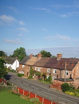
Snarestone is a small rural village in North West Leicestershire
, England
.
It lies on the edge of the National Forest
and is 5 miles (8 km) from the market town of Ashby-de-la-Zouch
. It has a population of approximately 300 people and 120 households.
The village is surrounded by farmland and open countryside. It is positioned at the foot of a slight hill that gently rises to a height of 115 metres. Other topographical features include the River Mease
and the terminus for the Ashby Canal. Both of these waterways are sites of special scientific interest (SSSI)
.
 Although Snarestone is a Leicestershire
village it has a Derbyshire
postcode and is 3 miles (5 km) from the county boundary of North Warwickshire
. The village has an active Parish Council that meets throughout the year and publishes a regular newsletter.
Snarestone's amenities include two public houses, a primary school, a church, a blacksmith
s,an antique reclamation yard, an allotment
, a post box
and a traditional red telephone kiosk
.
The village has various types of housing from thatched roof cottages, semi-detached
houses, self-contained flats to large detached properties, complete with private tennis courts. Most settlements in the village extend along Main Road and Quarry Lane. There is another minor road (Derby Lane) that connects to neighbouring Shackerstone
.
The village is served by an ADSL enabled telephone exchange that is capable of providing broadband access to the internet at speeds of 2 Mbit/s.
Refuse and recycling collections take place on a bi-weekly rota and a mobile public library makes regular stops in the village on alternate Friday's.
A mobile fish and chip van also visits the village on Thursday evenings.
An ATM
cash machine is housed in the Globe Pub and the nearest supermarket
s are located 2 miles (3 km) away in Measham
. Snarestone's other public house (the Odd House) is located at the very top of Main Road and offers overnight accommodation.
The area to the south of Snarestone is Crown Estate
land and belongs to (but is not the private property of) the British Monarch. Much of this land is agricultural and is the site of a former Georgian
country house (Gopsall Hall
). It is reputed that George Frideric Handel
composed his Messiah
oratorio
here in 1741.
and is less than 30 miles (48 km) from the five surrounding cities of Birmingham
, Leicester
, Nottingham
, Coventry
, and Derby
.
Other nearby roads include the A444
that runs to Coventry and the B4116 Ashby Road to Atherstone.
East Midlands Airport is situated 13 miles (21 km) to the north and Birmingham International Airport lies 23 miles (37 km) to the south.
. The canal crosses through the village and terminates in fields just to the north. The 22 miles (35 km) canal meanders through a gentle rural landscape and is free of lock
s.
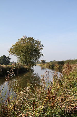 The canal is popular with leisure boaters, angler
s and wildlife enthusiasts. Hedgerows and reeds offer an ideal habitat for many species of plant and animal including heron
s, kingfisher
s, moorhen
s as well as numerous coarse fish including bream, roach
, chub
and pike
. A stretch of the canal between Snarestone and Carlton
has been designated a Site of Special Scientific Interest
(SSSI), mainly because of the aquatic plant life and varieties of dragonfly attracted to the area.
In 2005 the Government approved plans to restore a 2.5 miles (4 km) stretch of the canal to provide Snarestone with a green route into the heart of the National Forest. The proposals also include a canal side wharf for the new terminus at Measham.
and cyclists. A long distance trail (the Ivanhoe Way) also crosses through the village and runs for 35 miles through the Leicestershire
countryside.
Every year in November the Globe Inn hosts a large bonfire
and firework display to celebrate Guy Fawkes Night
. The event has gained local popularity and attracts many visitors from outside the village. In the Spring and Autumn the residents of Snarestone often race rubber ducks on a nearby stream to raise funds for village improvements. Most years the villagers also organise a summer fete
with street parades and various entertainments (the last one took place in 2007).
Other nearby attractions include Twycross Zoo
, Ashby de la Zouch Castle
, Conkers Visitor Centre, Snibston Discovery Park, Bosworth Battlefield
, Ashby Woulds Heritage Trail, the National Forest and a railway preservation society (The Battlefield Line
) that has its own rolling stock, museum and track.
Every February during half-term locals of the village perform an amateur pantomime at the primary school. The money raised goes towards charity. For 2010 the money was donated to the Haiti Appeal.
as Snarchetone and was the farmstead of a man called Snar(o)c.
At the time of Domesday Snarestone amounted to a single carucate
of waste land. This small area of land was held in 1086 by Robert the Dispensator (or Robert the Bursar). Robert was steward to William the Conqueror and the land was granted by Robert's successor (Henry de Hastynges) to a Adam Stake.
At some time during the thirteenth century the land passed to the Charnell family who held it for the following five centuries. By 1811 the lord of the manor was a Charles Powell Leslie and was passed in 1846 to Lady Anna Maria Leslie.
Snarestone's chief crops were wheat and barley. Bricks were made in the village during the nineteenth century and a coal mine was sunk in 1875 but found only water. The Ashby Canal opened in 1804 and still runs underneath a section of Main Street (formerly Long Street) via a 400 yard (366 m) tunnel.
By 1846 Snarestone had a population of 404 people. The Census
of 1891 recorded 302 people and by 1901 this figured had dropped to only 265 people.
The village church is dedicated to St. Bartholomew and has a register dating back to 1559. The church was rebuilt in 1752 and enlarged in 1834 to a capacity of 150 sittings.
In 1766 there were four alehouses in Snarestone. Records from 1772 reveal that George Gadsby was the landlord of a Crown Inn but the names of the other alehouses is not known. By 1785 the village had two pubs and by 1795 the Crown Inn was the only survivor of these early establishments. The Gadsby family had a long association with the Crown Inn that lasted until 1820. The pub still exists today as the Odd House.
Richard Roberts is also recorded as the landlord of the Square and Compass between 1855 and 1861 but its history is obscure. The Globe Inn first appears in the trade directories from 1870 onwards and still operates under the same name.
Between 1873 and 1967 Snarestone was a stop on the Ashby to Nuneaton railway line. The station building no longer exists although evidence of platforms can still be found. The goods shed
and station master's house remain but have been converted into private households.
Information on the regions railway heritage can be found in The Battlefield Line
Museum in neighbouring Shackerstone. The museum contains photographs of Snarestone station prior to its closure in the 1960s.
The neighbouring village of Newton Burgoland also claims to have the oldest public house in Leicestershire (The Belper Arms) which was built circa 1290.
North West Leicestershire
North West Leicestershire is a local government district in Leicestershire, England. Its main towns are Ashby-de-la-Zouch and Coalville.The district contains East Midlands Airport, which operates flights to the rest of Britain and to various places in Europe...
, England
England
England is a country that is part of the United Kingdom. It shares land borders with Scotland to the north and Wales to the west; the Irish Sea is to the north west, the Celtic Sea to the south west, with the North Sea to the east and the English Channel to the south separating it from continental...
.
It lies on the edge of the National Forest
National Forest, England
The National Forest is one of England’s most ambitious environmental projects. Across parts of Leicestershire, Derbyshire and Staffordshire, are being transformed, blending ancient woodland with new planting to create a new national forest...
and is 5 miles (8 km) from the market town of Ashby-de-la-Zouch
Ashby-de-la-Zouch
Ashby-de-la-Zouch, — Zouch being pronounced "Zoosh" — often shortened to Ashby, is a small market town and civil parish in North West Leicestershire, England, within the National Forest. It is twinned with Pithiviers in north-central France....
. It has a population of approximately 300 people and 120 households.
The village is surrounded by farmland and open countryside. It is positioned at the foot of a slight hill that gently rises to a height of 115 metres. Other topographical features include the River Mease
River Mease
The River Mease is a lowland clay river in the Midlands area of England. It flows through the counties of Leicestershire, Derbyshire and Staffordshire and forms the administrative border between these counties for parts of its length....
and the terminus for the Ashby Canal. Both of these waterways are sites of special scientific interest (SSSI)
Site of Special Scientific Interest
A Site of Special Scientific Interest is a conservation designation denoting a protected area in the United Kingdom. SSSIs are the basic building block of site-based nature conservation legislation and most other legal nature/geological conservation designations in Great Britain are based upon...
.
Village Features
Leicestershire
Leicestershire is a landlocked county in the English Midlands. It takes its name from the heavily populated City of Leicester, traditionally its administrative centre, although the City of Leicester unitary authority is today administered separately from the rest of Leicestershire...
village it has a Derbyshire
Derbyshire
Derbyshire is a county in the East Midlands of England. A substantial portion of the Peak District National Park lies within Derbyshire. The northern part of Derbyshire overlaps with the Pennines, a famous chain of hills and mountains. The county contains within its boundary of approx...
postcode and is 3 miles (5 km) from the county boundary of North Warwickshire
North Warwickshire
North Warwickshire is a local government district and borough in Warwickshire, England. The main town in the district is Atherstone where the council is based...
. The village has an active Parish Council that meets throughout the year and publishes a regular newsletter.
Snarestone's amenities include two public houses, a primary school, a church, a blacksmith
Blacksmith
A blacksmith is a person who creates objects from wrought iron or steel by forging the metal; that is, by using tools to hammer, bend, and cut...
s,an antique reclamation yard, an allotment
Allotment (gardening)
An allotment garden, often called simply an allotment, is a plot of land made available for individual, non-professional gardening. Such plots are formed by subdividing a piece of land into a few or up to several hundreds of land parcels that are assigned to individuals or families...
, a post box
Post box
A post box is a physical box into which members of the public can deposit outgoing mail intended for collection by the agents of a country's postal service...
and a traditional red telephone kiosk
Red telephone box
The red telephone box, a public telephone kiosk designed by Sir Giles Gilbert Scott, is a familiar sight on the streets of the United Kingdom, Malta, Bermuda and Gibraltar, and despite a reduction in their numbers in recent years, red boxes can still be seen in many places and in current or former...
.
The village has various types of housing from thatched roof cottages, semi-detached
Semi-detached
Semi-detached housing consists of pairs of houses built side by side as units sharing a party wall and usually in such a way that each house's layout is a mirror image of its twin...
houses, self-contained flats to large detached properties, complete with private tennis courts. Most settlements in the village extend along Main Road and Quarry Lane. There is another minor road (Derby Lane) that connects to neighbouring Shackerstone
Shackerstone
Shackerstone is a village and civil parish in the Hinckley and Bosworth district of Leicestershire, England. It is situated on the Ashby-de-la-Zouch Canal and the River Sence. According to the 2001 census the parish, which also includes the village of Barton in the Beans, had a population of...
.
The village is served by an ADSL enabled telephone exchange that is capable of providing broadband access to the internet at speeds of 2 Mbit/s.
Refuse and recycling collections take place on a bi-weekly rota and a mobile public library makes regular stops in the village on alternate Friday's.
A mobile fish and chip van also visits the village on Thursday evenings.
An ATM
Automated teller machine
An automated teller machine or automatic teller machine, also known as a Cashpoint , cash machine or sometimes a hole in the wall in British English, is a computerised telecommunications device that provides the clients of a financial institution with access to financial transactions in a public...
cash machine is housed in the Globe Pub and the nearest supermarket
Supermarket
A supermarket, a form of grocery store, is a self-service store offering a wide variety of food and household merchandise, organized into departments...
s are located 2 miles (3 km) away in Measham
Measham
Measham is a village in Leicestershire, near the Staffordshire and Derbyshire border, located just off the A42 just south of Ashby-de-la-Zouch, and within the National Forest...
. Snarestone's other public house (the Odd House) is located at the very top of Main Road and offers overnight accommodation.
The area to the south of Snarestone is Crown Estate
Crown Estate
In the United Kingdom, the Crown Estate is a property portfolio owned by the Crown. Although still belonging to the monarch and inherent with the accession of the throne, it is no longer the private property of the reigning monarch and cannot be sold by him/her, nor do the revenues from it belong...
land and belongs to (but is not the private property of) the British Monarch. Much of this land is agricultural and is the site of a former Georgian
Georgian architecture
Georgian architecture is the name given in most English-speaking countries to the set of architectural styles current between 1720 and 1840. It is eponymous for the first four British monarchs of the House of Hanover—George I of Great Britain, George II of Great Britain, George III of the United...
country house (Gopsall Hall
Gopsall
Gopsall is an area of Crown Estate land in North West Leicestershire, England. It is located between the villages of Appleby Magna, Shackerstone, Twycross and Snarestone....
). It is reputed that George Frideric Handel
George Frideric Handel
George Frideric Handel was a German-British Baroque composer, famous for his operas, oratorios, anthems and organ concertos. Handel was born in 1685, in a family indifferent to music...
composed his Messiah
Messiah (Handel)
Messiah is an English-language oratorio composed in 1741 by George Frideric Handel, with a scriptural text compiled by Charles Jennens from the King James Bible and the Book of Common Prayer. It was first performed in Dublin on 13 April 1742, and received its London premiere nearly a year later...
oratorio
Oratorio
An oratorio is a large musical composition including an orchestra, a choir, and soloists. Like an opera, an oratorio includes the use of a choir, soloists, an ensemble, various distinguishable characters, and arias...
here in 1741.
Transport
Snarestone is 2 miles (3 km) from junction 11 of the M42 motorwayM42 motorway
The M42 motorway is a major road in England. The motorway runs north east from Bromsgrove in Worcestershire to just south west of Ashby-de-la-Zouch in Leicestershire, passing Redditch, Solihull, the National Exhibition Centre and Tamworth on the way. The section between the M40 and M6 road forms...
and is less than 30 miles (48 km) from the five surrounding cities of Birmingham
Birmingham
Birmingham is a city and metropolitan borough in the West Midlands of England. It is the most populous British city outside the capital London, with a population of 1,036,900 , and lies at the heart of the West Midlands conurbation, the second most populous urban area in the United Kingdom with a...
, Leicester
Leicester
Leicester is a city and unitary authority in the East Midlands of England, and the county town of Leicestershire. The city lies on the River Soar and at the edge of the National Forest...
, Nottingham
Nottingham
Nottingham is a city and unitary authority in the East Midlands of England. It is located in the ceremonial county of Nottinghamshire and represents one of eight members of the English Core Cities Group...
, Coventry
Coventry
Coventry is a city and metropolitan borough in the county of West Midlands in England. Coventry is the 9th largest city in England and the 11th largest in the United Kingdom. It is also the second largest city in the English Midlands, after Birmingham, with a population of 300,848, although...
, and Derby
Derby
Derby , is a city and unitary authority in the East Midlands region of England. It lies upon the banks of the River Derwent and is located in the south of the ceremonial county of Derbyshire. In the 2001 census, the population of the city was 233,700, whilst that of the Derby Urban Area was 229,407...
.
Other nearby roads include the A444
A444 road
The A444 is a primary road running between Coventry and Burton on Trent in England, usually referred to as the "A treble four".-Route:Starting on the A4600 Sky Blue Way in Coventry, the road heads north on a dual carriageway road, crossing the M6 at junction 3. It bypasses Bedworth to the west and...
that runs to Coventry and the B4116 Ashby Road to Atherstone.
East Midlands Airport is situated 13 miles (21 km) to the north and Birmingham International Airport lies 23 miles (37 km) to the south.
Ashby Canal
Snarestone is linked via the Ashby Canal to the national network of British WaterwaysBritish Waterways
British Waterways is a statutory corporation wholly owned by the government of the United Kingdom, serving as the navigation authority in England, Scotland and Wales for the vast majority of the canals as well as a number of rivers and docks...
. The canal crosses through the village and terminates in fields just to the north. The 22 miles (35 km) canal meanders through a gentle rural landscape and is free of lock
Lock (water transport)
A lock is a device for raising and lowering boats between stretches of water of different levels on river and canal waterways. The distinguishing feature of a lock is a fixed chamber in which the water level can be varied; whereas in a caisson lock, a boat lift, or on a canal inclined plane, it is...
s.
Angling
Angling is a method of fishing by means of an "angle" . The hook is usually attached to a fishing line and the line is often attached to a fishing rod. Fishing rods are usually fitted with a fishing reel that functions as a mechanism for storing, retrieving and paying out the line. The hook itself...
s and wildlife enthusiasts. Hedgerows and reeds offer an ideal habitat for many species of plant and animal including heron
Heron
The herons are long-legged freshwater and coastal birds in the family Ardeidae. There are 64 recognised species in this family. Some are called "egrets" or "bitterns" instead of "heron"....
s, kingfisher
Kingfisher
Kingfishers are a group of small to medium sized brightly coloured birds in the order Coraciiformes. They have a cosmopolitan distribution, with most species being found in the Old World and Australia...
s, moorhen
Moorhen
Moorhens, sometimes called marsh hens, are medium-sized water birds that are members of the rail family Rallidae. They constitute the genus Gallinula....
s as well as numerous coarse fish including bream, roach
Rutilus
Rutilus is a genus of fishes in the family Cyprinidae, commonly called roaches. Locally, the name "roach" without any further qualifiers is also used for particular species, particularly the Common Roach Rutilus (Latin for "shining, red, golden, auburn") is a genus of fishes in the family...
, chub
European chub
The European chub , sometimes called the round chub, fat chub, chevin, pollard or simply "the" chub, is a freshwater fish of the family Cyprinidae...
and pike
Northern Pike
The northern pike , is a species of carnivorous fish of the genus Esox...
. A stretch of the canal between Snarestone and Carlton
Carlton, Leicestershire
Carlton is a village in Leicestershire, England, close to Market Bosworth.There are four roads in Carlton: Main Street , Bosworth Road , Congerstone Lane and Shackerstone Walk .- Village...
has been designated a Site of Special Scientific Interest
Site of Special Scientific Interest
A Site of Special Scientific Interest is a conservation designation denoting a protected area in the United Kingdom. SSSIs are the basic building block of site-based nature conservation legislation and most other legal nature/geological conservation designations in Great Britain are based upon...
(SSSI), mainly because of the aquatic plant life and varieties of dragonfly attracted to the area.
In 2005 the Government approved plans to restore a 2.5 miles (4 km) stretch of the canal to provide Snarestone with a green route into the heart of the National Forest. The proposals also include a canal side wharf for the new terminus at Measham.
Events and Attractions
The quiet lanes and canal paths that surround Snarestone are popular with walkers, ramblersRamblers
The Ramblers, formerly known as the Ramblers' Association, is the largest walkers' rights organisation in Great Britain which aims to look after the interests of walkers...
and cyclists. A long distance trail (the Ivanhoe Way) also crosses through the village and runs for 35 miles through the Leicestershire
Leicestershire
Leicestershire is a landlocked county in the English Midlands. It takes its name from the heavily populated City of Leicester, traditionally its administrative centre, although the City of Leicester unitary authority is today administered separately from the rest of Leicestershire...
countryside.
Every year in November the Globe Inn hosts a large bonfire
Bonfire
A bonfire is a controlled outdoor fire used for informal disposal of burnable waste material or as part of a celebration. Celebratory bonfires are typically designed to burn quickly and may be very large...
and firework display to celebrate Guy Fawkes Night
Guy Fawkes Night
Guy Fawkes Night, also known as Guy Fawkes Day, Bonfire Night and Firework Night, is an annual commemoration observed on 5 November, primarily in England. Its history begins with the events of 5 November 1605, when Guy Fawkes, a member of the Gunpowder Plot, was arrested while guarding...
. The event has gained local popularity and attracts many visitors from outside the village. In the Spring and Autumn the residents of Snarestone often race rubber ducks on a nearby stream to raise funds for village improvements. Most years the villagers also organise a summer fete
Fête
Fête is a French word meaning festival, celebration or party, which has passed into English as a label that may be given to certain events.-Description:It is widely used in England and Australia in the context of a village fête,...
with street parades and various entertainments (the last one took place in 2007).
Other nearby attractions include Twycross Zoo
Twycross Zoo
Twycross Zoo is an zoo near the village of Twycross in Leicestershire, close to the border of Warwickshire . The zoo claims the largest collections of monkeys and apes in the World, and in 2006 re-launched itself as "Twycross Zoo – The World Primate Centre."The zoo attracts around 500,000 visitors...
, Ashby de la Zouch Castle
Ashby de la Zouch Castle
Ashby de la Zouch Castle is in the town of Ashby-de-la-Zouch, Leicestershire, England . The ruins have been designated by English Heritage as a Grade I listed building, and they are a Scheduled Ancient Monument...
, Conkers Visitor Centre, Snibston Discovery Park, Bosworth Battlefield
Battle of Bosworth Field
The Battle of Bosworth Field was the penultimate battle of the Wars of the Roses, the civil war between the House of Lancaster and the House of York that raged across England in the latter half of the 15th century. Fought on 22 August 1485, the battle was won by the Lancastrians...
, Ashby Woulds Heritage Trail, the National Forest and a railway preservation society (The Battlefield Line
Battlefield Line Railway
The Battlefield Line Railway is a heritage railway in Leicestershire, England. It runs from Shackerstone to Shenton , via Market Bosworth, a total of...
) that has its own rolling stock, museum and track.
Every February during half-term locals of the village perform an amateur pantomime at the primary school. The money raised goes towards charity. For 2010 the money was donated to the Haiti Appeal.
Brief history
The village appears in the Domesday BookDomesday Book
Domesday Book , now held at The National Archives, Kew, Richmond upon Thames in South West London, is the record of the great survey of much of England and parts of Wales completed in 1086...
as Snarchetone and was the farmstead of a man called Snar(o)c.
At the time of Domesday Snarestone amounted to a single carucate
Carucate
The carucate or ploughland was a unit of assessment for tax used in most Danelaw counties of England, and is found for example in Domesday Book. The carucate was based on the area a plough team of eight oxen could till in a single annual season...
of waste land. This small area of land was held in 1086 by Robert the Dispensator (or Robert the Bursar). Robert was steward to William the Conqueror and the land was granted by Robert's successor (Henry de Hastynges) to a Adam Stake.
At some time during the thirteenth century the land passed to the Charnell family who held it for the following five centuries. By 1811 the lord of the manor was a Charles Powell Leslie and was passed in 1846 to Lady Anna Maria Leslie.
Snarestone's chief crops were wheat and barley. Bricks were made in the village during the nineteenth century and a coal mine was sunk in 1875 but found only water. The Ashby Canal opened in 1804 and still runs underneath a section of Main Street (formerly Long Street) via a 400 yard (366 m) tunnel.
By 1846 Snarestone had a population of 404 people. The Census
Census
A census is the procedure of systematically acquiring and recording information about the members of a given population. It is a regularly occurring and official count of a particular population. The term is used mostly in connection with national population and housing censuses; other common...
of 1891 recorded 302 people and by 1901 this figured had dropped to only 265 people.
The village church is dedicated to St. Bartholomew and has a register dating back to 1559. The church was rebuilt in 1752 and enlarged in 1834 to a capacity of 150 sittings.
In 1766 there were four alehouses in Snarestone. Records from 1772 reveal that George Gadsby was the landlord of a Crown Inn but the names of the other alehouses is not known. By 1785 the village had two pubs and by 1795 the Crown Inn was the only survivor of these early establishments. The Gadsby family had a long association with the Crown Inn that lasted until 1820. The pub still exists today as the Odd House.
Richard Roberts is also recorded as the landlord of the Square and Compass between 1855 and 1861 but its history is obscure. The Globe Inn first appears in the trade directories from 1870 onwards and still operates under the same name.
Between 1873 and 1967 Snarestone was a stop on the Ashby to Nuneaton railway line. The station building no longer exists although evidence of platforms can still be found. The goods shed
Goods shed
A goods shed is a railway building designed for storing goods before or after carriage in a train.A typical goods shed will have a track running through it to allow goods wagons to be unloaded under cover, although sometimes they were built alongside a track with possibly just a canopy over the door...
and station master's house remain but have been converted into private households.
Information on the regions railway heritage can be found in The Battlefield Line
Battlefield Line Railway
The Battlefield Line Railway is a heritage railway in Leicestershire, England. It runs from Shackerstone to Shenton , via Market Bosworth, a total of...
Museum in neighbouring Shackerstone. The museum contains photographs of Snarestone station prior to its closure in the 1960s.
The neighbouring village of Newton Burgoland also claims to have the oldest public house in Leicestershire (The Belper Arms) which was built circa 1290.
Nearby Towns
- Ashby de la Zouch
- Burton Upon TrentBurton upon TrentBurton upon Trent, also known as Burton-on-Trent or simply Burton, is a town straddling the River Trent in the east of Staffordshire, England. Its associated adjective is "Burtonian"....
- AtherstoneAtherstoneAtherstone is a town in Warwickshire, England. The town is located near the northernmost tip of Warwickshire, close to the border with Staffordshire and Leicestershire and is the administrative headquarters of the borough of North Warwickshire.-History:...
- CoalvilleCoalvilleCoalville is a town in North West Leicestershire, England, with a population estimated in 2003 to be almost 33,000. It is situated on the A511 trunk road between Leicester and Burton upon Trent, close to junction 22 of the M1 motorway where the A511 meets the A50 between Ashby-de-la-Zouch and...
- HinckleyHinckleyHinckley is a town in southwest Leicestershire, England. It has a population of 43,246 . It is administered by Hinckley and Bosworth Borough Council...
- IbstockIbstockIbstock is a village and civil parish about south of Coalville in North West Leicestershire, England. The village is on the A447 road Between Coalville and Hinckley....
- Market BosworthMarket BosworthMarket Bosworth is a small market town and civil parish in Leicestershire, England. It formerly formed a district known as the Market Bosworth Rural District. In 1974 it merged with the Hinckley Rural District to form a new district named Hinckley and Bosworth...
- NuneatonNuneatonNuneaton is the largest town in the Borough of Nuneaton and Bedworth and in the English county of Warwickshire.Nuneaton is most famous for its associations with the 19th century author George Eliot, who was born on a farm on the Arbury Estate just outside Nuneaton in 1819 and lived in the town for...
- TamworthTamworthTamworth is a town and local government district in Staffordshire, England, located north-east of Birmingham city centre and north-west of London. The town takes its name from the River Tame, which flows through the town, as does the River Anker...
Surrounding Villages
- Appleby MagnaAppleby MagnaAppleby Magna is a village and civil parish in the district of North West Leicestershire, England.The civil parish, as well as Appleby Magna, includes the small Hamlet of Appleby Parva and the Villages of Norton-Juxta-Twycross, Snarestone and Swepstone...
- Barton in the BeansBarton in the BeansBarton in the Beans is a hamlet in the Hinckley and Bosworth district of Leicestershire, England and forms part of the Shackerstone civil parish. There are no shops or pubs here, only a Baptist Church and a post box. It was in the 18th century an important centre for the Baptist Church and the...
- Bilstone
- CarltonCarlton, LeicestershireCarlton is a village in Leicestershire, England, close to Market Bosworth.There are four roads in Carlton: Main Street , Bosworth Road , Congerstone Lane and Shackerstone Walk .- Village...
- CongerstoneCongerstoneCongerstone is a small settlement in Leicestershire, England. It is near the Ashby-de-la-Zouch Canal and the A444 road.-External links:*...
- MeashamMeashamMeasham is a village in Leicestershire, near the Staffordshire and Derbyshire border, located just off the A42 just south of Ashby-de-la-Zouch, and within the National Forest...
- OdstoneOdstoneOdstone is a hamlet forming part of the Shackerstone civil parish in the Hinckley and Bosworth district of Leicestershire, England. It stands on a marked promontory of high ground between two river valleys....
- Norton-Juxta-Twycross
- Newton BurgolandNewton BurgolandNewton Burgoland is a hamlet forming part of the Swepstone civil parish in the North West Leicestershire district of Leicestershire, England. The Swepstone parish also includes a small settlement named Newton-Nethercote, which forms as part of the village....
- ShackerstoneShackerstoneShackerstone is a village and civil parish in the Hinckley and Bosworth district of Leicestershire, England. It is situated on the Ashby-de-la-Zouch Canal and the River Sence. According to the 2001 census the parish, which also includes the village of Barton in the Beans, had a population of...
- Sheepy Magna
- SwepstoneSwepstoneSwepstone is a village and civil parish in the North West Leicestershire district of Leicestershire, England, about five miles south of Ashby de la Zouch. The parish includes the villages of Swepstone and Newton Burgoland....
- TwycrossTwycrossTwycross is a small village and civil parish in Leicestershire, England on the A444 road. Parts of it are called Norton juxta — Latin for 'next to' — Twycross or Little Twycross...
External links
- 1923 Ordnance Survey map of Snarestone
- Snarestone Village Website
- National Forest Website
- Conkers Website
- Twycross Zoo Website
- Shackerstone Railway Society Ltd
- Bosworth Battlefield Centre and Country Park
- Ashby Canal Restoration Project Executive Summary by Leicestershire County Council
See also
Battle of Bosworth FieldBattle of Bosworth Field
The Battle of Bosworth Field was the penultimate battle of the Wars of the Roses, the civil war between the House of Lancaster and the House of York that raged across England in the latter half of the 15th century. Fought on 22 August 1485, the battle was won by the Lancastrians...