

Sir Creek
Encyclopedia
The Sir Creek is a 96 km (60 mi) strip of water
disputed between India
and Pakistan
in the Rann of Kutch
marshlands. The creek, which opens up into the Arabian Sea
, divides the Kutch region of the Indian state
of Gujarat with the Sindh
province of Pakistan. It is located at approximately 23°58′N 68°48′E.Originally and locally it is called 'Baan Ganga'. Sir Creek is named after the British
representative.
The long-standing dispute hinges in the actual demarcation "from the mouth of Sir Creek to the top of Sir Creek, and from the top of Sir Creek eastward to a point on the line designated on the Western Terminus". From this point onwards, the boundary is unambiguously fixed as defined by the Tribunal Award of 1968.
The creek itself is located in the uninhabited marshlands. During the monsoon season between June and September, the creek floods its banks and envelops the low-lying salty mudflats around it. During the winter season, the area is home to flamingoes and other migratory birds.
line between Kutch and Sindh. Before India's independence, the provincial region was a part of Bombay Presidency
of British India. After India's independence
in 1947, Sindh became a part of Pakistan while Kutch remained a part of India.
Pakistan lays claim to the entire creek as per paras 9 and 10 of the Bombay Government Resolution of 1914 signed between then the Government of Sindh
and Rao Maharaj of Kutch.
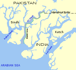 The resolution, which demarcated the boundaries between the two territories, included the creek as part of Sindh, thus setting the boundary as the eastern flank of the creek. The boundary line, known as the "Green Line", is disputed by India which maintains that it is an "indicative line", known as a "ribbon line" in technical jargon. India sticks to its position that the boundary lies mid-channel as depicted in another map drawn in 1925, and implemented by the installation of mid-channel pillars back in 1924.
India supports its stance by citing the Thalweg Doctrine in International Law
. The law states that river boundaries between two states may be, if the two states agree, divided by the mid-channel. Though Pakistan does not dispute the 1925 map, it maintains that the Doctrine is not applicable in this case as it only applies to bodies of water that are navigable, which the Sir Creek is not. India rejects the Pakistani stance by maintaining the fact that the creek is navigable in high tide
, and that fishing trawlers use it to go out to sea. Several cartographic surveys conducted have upheld the Indian claim. Another point of concern for Pakistan is that Sir Creek has changed its course considerably over the years. If the boundary line is demarcated according to the Thalweg principle, Pakistan stands to lose a considerable portion of the territory that was historically part of the province of Sindh. Acceding to India's stance would also result in the shifting of the land/sea terminus point several kilometres to the detriment of Pakistan, leading in turn to a loss of several thousand square kilometres of its Exclusive Economic Zone
under the United Nations Convention on Law of the Sea.
In April 1965, a dispute there contributed to the Indo-Pakistani War of 1965
, when fighting broke out between India and Pakistan. Later the same year, British Prime Minister Harold Wilson
successfully persuaded both countries to end hostilities and set up a tribunal to resolve the dispute. A verdict was reached in 1968 which saw Pakistan getting 10% of its claim of 9,000 km² (3,500 sq. miles).
The disputed region was at the center of international attention in 1999 after Mig-21 fighter planes of the Indian Air Force
shot down a Pakistani Navy Breguet Atlantique
surveillance aircraft over the Sir Creek on August 10, 1999, killing all 16 on board. India claimed that the plane had strayed into its airspace, which was disputed by the Pakistani navy. (See the Atlantique Incident
).
The demarcation would also prevent the inadvertent crossing over of fishermen of both nations into each others' territories.
Since neither side has conceded ground, India has proposed that the maritime boundary could be demarcated first, as per the provisions of Technical Aspects of Law of Sea (TALOS). However, Pakistan has staunchly refused the proposal on the grounds that the dispute should be resolved first. Pakistan has also proposed that the two sides go in for international arbitration, which India has flatly refused. India maintains that all bilateral disputes should be resolved without the intervention of third-parties.
Creek (tidal)
A tidal creek, tidal channel, or estuary is the portion of a stream that is affected by ebb and flow of ocean tides, in the case that the subject stream discharges to an ocean, sea or strait. Thus this portion of the stream has variable salinity and electrical conductivity over the tidal cycle...
disputed between India
India
India , officially the Republic of India , is a country in South Asia. It is the seventh-largest country by geographical area, the second-most populous country with over 1.2 billion people, and the most populous democracy in the world...
and Pakistan
Pakistan
Pakistan , officially the Islamic Republic of Pakistan is a sovereign state in South Asia. It has a coastline along the Arabian Sea and the Gulf of Oman in the south and is bordered by Afghanistan and Iran in the west, India in the east and China in the far northeast. In the north, Tajikistan...
in the Rann of Kutch
Rann of Kutch
The Great Rann of Kutch, also called Greater Rann of Kutch or just Rann of Kutch , is a seasonal salt marsh located in the Thar Desert in the Kutch District of Gujarat, India and the Sindh province of Pakistan....
marshlands. The creek, which opens up into the Arabian Sea
Arabian Sea
The Arabian Sea is a region of the Indian Ocean bounded on the east by India, on the north by Pakistan and Iran, on the west by the Arabian Peninsula, on the south, approximately, by a line between Cape Guardafui in northeastern Somalia and Kanyakumari in India...
, divides the Kutch region of the Indian state
States and territories of India
India is a federal union of states comprising twenty-eight states and seven union territories. The states and territories are further subdivided into districts and so on.-List of states and territories:...
of Gujarat with the Sindh
Sindh
Sindh historically referred to as Ba'ab-ul-Islam , is one of the four provinces of Pakistan and historically is home to the Sindhi people. It is also locally known as the "Mehran". Though Muslims form the largest religious group in Sindh, a good number of Christians, Zoroastrians and Hindus can...
province of Pakistan. It is located at approximately 23°58′N 68°48′E.Originally and locally it is called 'Baan Ganga'. Sir Creek is named after the British
United Kingdom
The United Kingdom of Great Britain and Northern IrelandIn the United Kingdom and Dependencies, other languages have been officially recognised as legitimate autochthonous languages under the European Charter for Regional or Minority Languages...
representative.
The long-standing dispute hinges in the actual demarcation "from the mouth of Sir Creek to the top of Sir Creek, and from the top of Sir Creek eastward to a point on the line designated on the Western Terminus". From this point onwards, the boundary is unambiguously fixed as defined by the Tribunal Award of 1968.
The creek itself is located in the uninhabited marshlands. During the monsoon season between June and September, the creek floods its banks and envelops the low-lying salty mudflats around it. During the winter season, the area is home to flamingoes and other migratory birds.
Dispute
The dispute lies in the interpretation of the maritime boundaryMaritime boundary
Maritime boundary is a conceptual means of division of the water surface of the planet into maritime areas that are defined through surrounding physical geography or by human geography. As such it usually includes areas of exclusive national rights over the mineral and biological resources,...
line between Kutch and Sindh. Before India's independence, the provincial region was a part of Bombay Presidency
Bombay Presidency
The Bombay Presidency was a province of British India. It was established in the 17th century as a trading post for the English East India Company, but later grew to encompass much of western and central India, as well as parts of post-partition Pakistan and the Arabian Peninsula.At its greatest...
of British India. After India's independence
Indian independence movement
The term Indian independence movement encompasses a wide area of political organisations, philosophies, and movements which had the common aim of ending first British East India Company rule, and then British imperial authority, in parts of South Asia...
in 1947, Sindh became a part of Pakistan while Kutch remained a part of India.
Pakistan lays claim to the entire creek as per paras 9 and 10 of the Bombay Government Resolution of 1914 signed between then the Government of Sindh
Government of Sindh
Government of Sindh is based in Karachi, Sindh, Pakistan. سندھ is one of the four provinces of Pakistan and is home to the Sindhis, Muhajirs, Pashtuns and a whole array of other ethnic and linguistic groups. Neighbouring regions are Balochistan to the west and north, Punjab in the north and...
and Rao Maharaj of Kutch.
India supports its stance by citing the Thalweg Doctrine in International Law
International law
Public international law concerns the structure and conduct of sovereign states; analogous entities, such as the Holy See; and intergovernmental organizations. To a lesser degree, international law also may affect multinational corporations and individuals, an impact increasingly evolving beyond...
. The law states that river boundaries between two states may be, if the two states agree, divided by the mid-channel. Though Pakistan does not dispute the 1925 map, it maintains that the Doctrine is not applicable in this case as it only applies to bodies of water that are navigable, which the Sir Creek is not. India rejects the Pakistani stance by maintaining the fact that the creek is navigable in high tide
High Tide
High Tide was a band formed in 1969 by Tony Hill , Simon House , Peter Pavli and Roger Hadden .-History:...
, and that fishing trawlers use it to go out to sea. Several cartographic surveys conducted have upheld the Indian claim. Another point of concern for Pakistan is that Sir Creek has changed its course considerably over the years. If the boundary line is demarcated according to the Thalweg principle, Pakistan stands to lose a considerable portion of the territory that was historically part of the province of Sindh. Acceding to India's stance would also result in the shifting of the land/sea terminus point several kilometres to the detriment of Pakistan, leading in turn to a loss of several thousand square kilometres of its Exclusive Economic Zone
Exclusive Economic Zone
Under the law of the sea, an exclusive economic zone is a seazone over which a state has special rights over the exploration and use of marine resources, including production of energy from water and wind. It stretches from the seaward edge of the state's territorial sea out to 200 nautical...
under the United Nations Convention on Law of the Sea.
In April 1965, a dispute there contributed to the Indo-Pakistani War of 1965
Indo-Pakistani War of 1965
The Indo-Pakistani War of 1965 was a culmination of skirmishes that took place between April 1965 and September 1965 between Pakistan and India. This conflict became known as the Second Kashmir War fought by India and Pakistan over the disputed region of Kashmir, the first having been fought in 1947...
, when fighting broke out between India and Pakistan. Later the same year, British Prime Minister Harold Wilson
Harold Wilson
James Harold Wilson, Baron Wilson of Rievaulx, KG, OBE, FRS, FSS, PC was a British Labour Member of Parliament, Leader of the Labour Party. He was twice Prime Minister of the United Kingdom during the 1960s and 1970s, winning four general elections, including a minority government after the...
successfully persuaded both countries to end hostilities and set up a tribunal to resolve the dispute. A verdict was reached in 1968 which saw Pakistan getting 10% of its claim of 9,000 km² (3,500 sq. miles).
The disputed region was at the center of international attention in 1999 after Mig-21 fighter planes of the Indian Air Force
Indian Air Force
The Indian Air Force is the air arm of the Indian armed forces. Its primary responsibility is to secure Indian airspace and to conduct aerial warfare during a conflict...
shot down a Pakistani Navy Breguet Atlantique
Breguet Atlantique
The Breguet Br.1150 Atlantic is a long-range reconnaissance aircraft, primarily designed for use over the sea. It is used in several NATO countries as a reconnaissance and patrol aircraft as well as anti-submarine aircraft. The Atlantic is also capable of carrying air-to-ground missiles...
surveillance aircraft over the Sir Creek on August 10, 1999, killing all 16 on board. India claimed that the plane had strayed into its airspace, which was disputed by the Pakistani navy. (See the Atlantique Incident
Atlantique Incident
The Atlantique Incident was an event in which a Pakistan Navy's Naval Air Arm Breguet Atlantique patrol plane, carrying 16 people on board, was shot down by the Indian Air Force for alleged violation of airspace...
).
Economic reasons
Though the creek has little military value, it holds immense economic gain. Much of the region is rich in oil and gas below the sea bed, and control over the creek would have a huge bearing on the energy potential of each nation. Also once the boundaries are defined, it would help in the determination of the maritime boundaries which are drawn as an extension of onshore reference points. Maritime boundaries also help in determining the limits of Exclusive Economic Zones (EEZs) and continental shelves. EEZs extend to 200 nautical miles (370 km) and can be subjected to commercial exploitation.The demarcation would also prevent the inadvertent crossing over of fishermen of both nations into each others' territories.
Dispute resolution
Since 1969, there have been eight rounds of talks between the two nations, without a breakthrough. Steps to resolve the dispute include:- Allocation
- Delimitation
- Demarcation
- Administration
Since neither side has conceded ground, India has proposed that the maritime boundary could be demarcated first, as per the provisions of Technical Aspects of Law of Sea (TALOS). However, Pakistan has staunchly refused the proposal on the grounds that the dispute should be resolved first. Pakistan has also proposed that the two sides go in for international arbitration, which India has flatly refused. India maintains that all bilateral disputes should be resolved without the intervention of third-parties.
Further reading
- Bharat Bhushan, Tulbul, Sir Creek and Siachen: Competitive Methodologies, South Asian Journal, No.7 Jan-Mar 2005 accessed at http://www.southasianmedia.net/Magazine/journal/7_competitive_methodologies.htm July 26, 2006
- Indo-Pak composite dialogue: No movement on Sir Creek talks, By Zahid Gishkori, Express Tribune, Published: May 22, 2011
External links
- India, Pakistan in border talks BBC December 22, 2006