

Sinusoidal projection
Encyclopedia
Map projection
A map projection is any method of representing the surface of a sphere or other three-dimensional body on a plane. Map projections are necessary for creating maps. All map projections distort the surface in some fashion...
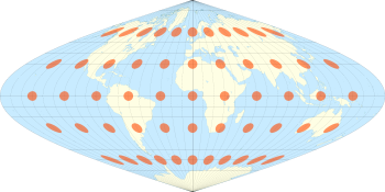
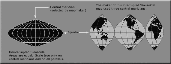
, sometimes called the Sanson–Flamsteed or the Mercator equal-area projection. Jean Cossin of Dieppe was one of the first mapmakers to use the sinusoidal, appearing in a world map of 1570. The projection is defined by:


where φ is the latitude, λ is the longitude, and λ0 is the central meridian.
The north-south scale is the same everywhere at the central meridian
Meridian (geography)
A meridian is an imaginary line on the Earth's surface from the North Pole to the South Pole that connects all locations along it with a given longitude. The position of a point along the meridian is given by its latitude. Each meridian is perpendicular to all circles of latitude...
, and the east-west scale is throughout the map the same as that; correspondingly, on the map, as in reality, the length of each parallel is proportional to the cosine of the latitude; thus the shape of the map for the whole earth is the area between two symmetric rotated cosine curves. The true distance between two points on the same meridian corresponds to the distance on the map between the two parallels, which is smaller than the distance between the two points on the map. There is no distortion on the central meridian or the equator
Equator
An equator is the intersection of a sphere's surface with the plane perpendicular to the sphere's axis of rotation and containing the sphere's center of mass....
.
North Pole
The North Pole, also known as the Geographic North Pole or Terrestrial North Pole, is, subject to the caveats explained below, defined as the point in the northern hemisphere where the Earth's axis of rotation meets its surface...
are the Werner
Werner projection
The Werner projection is a pseudoconic equal-area map projection sometimes called the Stab-Werner or Stabius-Werner projection. Like other heart-shaped projections, it is also categorized as cordiform...
and the intermediate Bonne
Bonne projection
A Bonne projection is a pseudoconical equal-area map projection, sometimes called a dépôt de la guerre or a Sylvanus projection. Although named after Rigobert Bonne , the projection was in use prior to his birth, in 1511 by Sylvano, Honter in 1561, De l'Isle before 1700 and Coronelli in 1696.The...
and Bottomley projections.
External links
- Cybergeo article
- Table of examples and properties of all common projections, from radicalcartography.net