
Seton Portage Historic Provincial Park
Encyclopedia
Seton Portage Historic Provincial Park is a provincial park
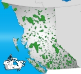
in British Columbia
, Canada
.
 It was established to commemorate the location of the first railway in the province of British Columbia. The 3 kilometres (1.9 mi) long railway was built in 1861 for transport of miners' goods on the route to the Fraser goldfields in which the Portage was an important link (then known as Short Portage). The railway was horse-drawn in the uphill direction - a difference of only 15m between the two lakes, and used gravity for its descent. Known as Dozier's Way after its proprietor, Carl Dozier, the roadbed of the route remains today as the route of most of Portage Road from Nkiat to the "downtown" of Seton Portage to Slosh, though part of its route is preserved by the historic park(Nkiat and Slosh are two First Nations villages which are where the one-time gold rush ports of Wapping and Flushing were located). Though the route was used for heavy transit again, the early railway operated only a few years, though some transport and passenger traveled through the route, despites its becoming a backwater relative to other areas of the province and the Douglas Road became forgotten. Seton Portage received its current name in 1858, the centennial of the gold rush and the colony
's creation, until which time it was known as the Short Portage - but also, with Shalalth, as "Seton". The Lillooet Cattle Trail
was built through the same route as the Douglas Road
but, despite an ingenious and fragile catwalk along the cliffs of eastern Seton Lake, was not usable in the long run and was abandoned and derelict by the time the Pacific Great Eastern connected the Seton communities to Lillooet in 1915.
hosts the present day information center.
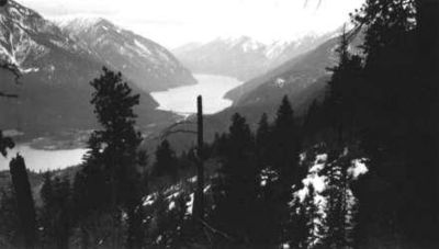
The park can be found west of Lillooet
, along the Seton River
, between Anderson Lake and Seton Lake
, immediately west of the settlement of Seton Portage
. Passenger service to this location is no longer available, other than a local run from Lillooet, on the Canadian National Railway
line. Access is otherwise via the arduous Mission Mountain Road or the even more difficult Anderson Lake Highline Road, which are Seton Portage's and Shalalth's only road access to the outside world.
It was established on March 29, 1972 on land donated by the British Columbia Railway to the province.
Provincial park
A provincial park is a park under the management of a provincial or territorial government in Canada.While provincial parks are not the same as national parks, their workings are very similar...
in British Columbia
British Columbia
British Columbia is the westernmost of Canada's provinces and is known for its natural beauty, as reflected in its Latin motto, Splendor sine occasu . Its name was chosen by Queen Victoria in 1858...
, Canada
Canada
Canada is a North American country consisting of ten provinces and three territories. Located in the northern part of the continent, it extends from the Atlantic Ocean in the east to the Pacific Ocean in the west, and northward into the Arctic Ocean...
.
Colony of British Columbia
The Colony of British Columbia was a crown colony in British North America from 1858 until 1866. At its creation, it physically constituted approximately half the present day Canadian province of British Columbia, since it did not include the Colony of Vancouver Island, the vast and still largely...
's creation, until which time it was known as the Short Portage - but also, with Shalalth, as "Seton". The Lillooet Cattle Trail
Lillooet Cattle Trail
The Lillooet Cattle Trail, also known as the Lillooet-Burrard Cattle Trail and also as the Lillooet Trail , was an unusual and daring public works undertaking by the Province of British Columbia in the 1877, and was the largest 19th Century public works expenditure at $35,000 of the new province...
was built through the same route as the Douglas Road
Douglas Road
The Douglas Road, aka the Lillooet Trail, Harrison Trail or Lakes Route, was a goldrush-era transportation route from the British Columbia Coast to the Interior...
but, despite an ingenious and fragile catwalk along the cliffs of eastern Seton Lake, was not usable in the long run and was abandoned and derelict by the time the Pacific Great Eastern connected the Seton communities to Lillooet in 1915.
Facilities
A gravel-bed campground is more suitable for vehicular camping than tenting, and is lcoated adjacent to the railway line through the Portage. The site is forested with pine and the light underbrush typical of the area's climate. Stores, a motel and restaurant are located within walking distance, as is the foot of Anderson Lake and the beaches there. At the park, in addition to campgrounds, picnic tables and sanitary facilities, an old railway cabooseCaboose
A caboose is a manned North American rail transport vehicle coupled at the end of a freight train. Although cabooses were once used on nearly every freight train, their use has declined and they are seldom seen on trains, except on locals and smaller railroads.-Function:The caboose provided the...
hosts the present day information center.
The park can be found west of Lillooet
Lillooet, British Columbia
Lillooet is a community on the Fraser River in western Canada, about up the British Columbia Railway line from Vancouver. Situated at an intersection of deep gorges in the lee of the Coast Mountains, it has a dry climate- of precipitation is recorded annually at the town's weather station,...
, along the Seton River
Seton River
The Seton River is a tributary of the Fraser River in the Canadian province of British Columbia.-Course:The Seton River originates at the foot of Anderson Lake and runs initially for only 3km to the head of Seton Lake...
, between Anderson Lake and Seton Lake
Seton Lake
Seton Lake is a freshwater fjord draining east via the Seton River into the Fraser River at the town of Lillooet, British Columbia, about 22 km long and 243 m in elevation and 26.2 square kilometres in area...
, immediately west of the settlement of Seton Portage
Seton Portage, British Columbia
Seton Portage is a historic rural community in British Columbia, Canada, that is about 25 km west of Lillooet, located between Seton Lake and Anderson Lake. "The Portage" was formed about 10,000 years ago when the flank of the Cayoosh Range, which is the south flank of the valley, let go and...
. Passenger service to this location is no longer available, other than a local run from Lillooet, on the Canadian National Railway
Canadian National Railway
The Canadian National Railway Company is a Canadian Class I railway headquartered in Montreal, Quebec. CN's slogan is "North America's Railroad"....
line. Access is otherwise via the arduous Mission Mountain Road or the even more difficult Anderson Lake Highline Road, which are Seton Portage's and Shalalth's only road access to the outside world.
It was established on March 29, 1972 on land donated by the British Columbia Railway to the province.