

Second Harbour Crossing
Encyclopedia
Waitemata Harbour
The quite famous Waitemata Harbour is the main access by sea to Auckland, New Zealand. For this reason it is often referred to as Auckland Harbour, despite the fact that it is only one of two harbours surrounding the city, and is crossed by the Auckland Harbour Bridge. The Waitemata forms the north...
in Auckland
Auckland
The Auckland metropolitan area , in the North Island of New Zealand, is the largest and most populous urban area in the country with residents, percent of the country's population. Auckland also has the largest Polynesian population of any city in the world...
, New Zealand
New Zealand
New Zealand is an island country in the south-western Pacific Ocean comprising two main landmasses and numerous smaller islands. The country is situated some east of Australia across the Tasman Sea, and roughly south of the Pacific island nations of New Caledonia, Fiji, and Tonga...
. The second link would supplement the Auckland Harbour Bridge
Auckland Harbour Bridge
The Auckland Harbour Bridge is an eight-lane box truss motorway bridge over the Waitemata Harbour, joining St Marys Bay in Auckland with Northcote in North Shore City, New Zealand. The bridge is part of State Highway 1 and the Auckland Northern Motorway...
which is nearly at capacity and also provide more redundancy and added public transport linkages between Auckland City
Auckland City
Auckland City was the city and local authority covering the Auckland isthmus and most of the islands of the Hauraki Gulf, in the North Island of New Zealand. On 1 November 2010 it was amalgamated into the wider Auckland Region under the authority of the new Auckland Council...
and North Shore City. It is sometimes also called the Third Harbour Crossing, as the Greenhithe Bridge
Upper Harbour Bridge
The Upper Harbour Bridge or Greenhithe Bridge is a motorway bridge , which spans over a reach of the Waitemata Harbour and connects Hobsonville and Greenhithe , New Zealand....
also exists.
Discussed since shortly after the Auckland Harbour Bridge was first built (and quickly reached capacity before being widened), the proposed crossing has by now (2008) been narrowed down from around 160 alignment options to a multi-tunnel link somewhat east of the existing bridge. However, the project is at least a decade away from funding as of the late 2000s. The project itself would likely take between 5 and 15 years once started, according to the New Zealand Transport Agency
New Zealand Transport Agency
The New Zealand Transport Agency is a New Zealand Crown entity tasked with promoting safe and functional transport by land, including the responsibility for driver and vehicle licensing and investigating rail accidents. It was created on 1 August 2008 by the Land Transport Management Amendment...
. In late 2009, the current National government declared it a priority in the new 20-year infrastructure plan.
Background
Even at the time the clip-on additions to the Auckland Harbour Bridge were being installed in 1969, predictions already noted that the increased bridge capacity would last only until about 1985. Even with the clip-on sections and the traffic management in place, the Harbour Bridge was soon experiencing severe congestion during rush hours again. Various plans were proposed for a second link in the following decades, including one connecting from Meola ReefMeola Reef
The Meola Reef, or Te Tokaroa Reef in Māori is a lava flow forming a reef peninsula across part of Auckland's Waitemata Harbour, New Zealand. It was formed 20,000 years ago from the final portion of a 10 kilometer long lava flow that originated from the distant Three Kings volcano...
to Birkenhead
Birkenhead
Birkenhead is a town within the Metropolitan Borough of Wirral in Merseyside, England. It is on the Wirral Peninsula, along the west bank of the River Mersey, opposite the city of Liverpool...
, though the idea was abandoned in the 1970s after public outcry.
It is expected that traffic congestion which will only get worse as North Shore City grows further, and Auckland City
Auckland City
Auckland City was the city and local authority covering the Auckland isthmus and most of the islands of the Hauraki Gulf, in the North Island of New Zealand. On 1 November 2010 it was amalgamated into the wider Auckland Region under the authority of the new Auckland Council...
becomes more densely settled. Therefore, there is growing pressure for another harbour crossing. Many have also noted that such reliance on a single asset (which might experience failure via an earthquake or other disaster) is not in the interests of either Auckland or New Zealand.
However, a 2007 study by the Auckland Regional Council
Auckland Regional Council
The Auckland Regional Council was the regional council of the Auckland Region. Its predecessor the Auckland Regional Authority was formed in 1963 and became the ARC in 1989...
has shown that peak hour
Rush hour
A rush hour or peak hour is a part of the day during which traffic congestion on roads and crowding on public transport is at its highest. Normally, this happens twice a day—once in the morning and once in the evening, the times during when the most people commute...
traffic volumes are actually down compared to early 1990s. The morning peak (from 7 am - 9 am) has dipped from 17,048 vehicles inbound (towards Auckland City) in 1991 to 16,032 vehicles in 2006 (though the opposing traffic did climb from 5,872 to 10,555 vehicles). At the same time, the afternoon peak (from 4 pm - 6 pm) has fallen from 17,092 vehicles outbound to 16,759 (though again, the opposing traffic rose substantially, from 6,944 to 10,991). This is generally attributed to travel demand management
Travel behavior
Travel behavior is the study of what people do over space, and how people use transport. The questions studied in travel behavior are broad, and are very much related to activity analysis and time use research studies.* How many trips do people make?...
, to drivers avoiding peak hours, and to increased bus usage since the construction of the hugely successful Northern Busway
Northern Busway, Auckland
thumb|Passengers boarding a [[MAXX Regional Transport]] Northern Express service operated by [[Ritchies Coachlines]].The Northern Busway is a physically separated busway with dedicated park & ride facilities along State Highway 1 in the north of Auckland, New Zealand, linking the North Shore with...
- 40% of peak time passengers are now carried by bus rather than cars. This has raised some doubts about whether a second crossing is actually necessary.
Several projects either side of the bridge are also currently (2007) underway or planned to ensure that the motorway capacity on both sides matches that of the peak time capacity of the bridge (a factor which is considered by some to be more of a bottleneck than the bridge capacity itself), and to enhance the attractiveness of public transport. These include the completed upgrade to the Central Motorway Junction
Central Motorway Junction
The Central Motorway Junction or CMJ , is the intersection of New Zealand State Highways 1 and 16, just south of the central business district of Auckland, New Zealand...
, the consented Harbour Bridge to City Tunnel (Victoria Park
Victoria Park, Auckland
Victoria Park is a park and sports ground in Auckland City, New Zealand. It lies on reclaimed bay land in Freemans Bay, a suburb directly west of the Auckland CBD. This origin of the land makes it very flat and level...
Tunnel, which will increase capacity between the Central Motorway Junction and the bridge by 50%) and the completed Northern Busway
Northern Busway, Auckland
thumb|Passengers boarding a [[MAXX Regional Transport]] Northern Express service operated by [[Ritchies Coachlines]].The Northern Busway is a physically separated busway with dedicated park & ride facilities along State Highway 1 in the north of Auckland, New Zealand, linking the North Shore with...
(which will provide a bypass parallel to the Northern motorway as it approaches the bridge). The future timing of an additional harbour crossing may also be delayed by the completion of the Western Ring Road (a combination of upgraded and new motorway sections skirting the western edge of the harbour and suburbs), which will provide some relief for traffic travelling between the North Shore City and West Auckland. This route is expected to be completed by 2020 at the latest.
At the moment, official political statements still conclude a second harbour crossing is to be delayed (though it should be noted that District Plan
District Plan
A District Plan is a statutory planning document of New Zealand's territorial authorities.Mainly covering land use/zoning questions, they have become required since the advent of the Resource Management Act 1991...
s are a type of document that is updated at best once or twice every decade):
- The Auckland City CouncilAuckland City CouncilAuckland City Council was the local government authority representing Auckland City, New Zealand, and was amalgamated into the Auckland Council on 1 November 2010. It was an elected body representing the 404,658 residents of the city...
will work with Transit New ZealandTransit New ZealandTransit New Zealand was, from 1989 to 2008, the New Zealand Crown entity responsible for operating and planning the New Zealand State Highway network...
, the ARCAuckland Regional CouncilThe Auckland Regional Council was the regional council of the Auckland Region. Its predecessor the Auckland Regional Authority was formed in 1963 and became the ARC in 1989...
, and the North Shore City Council to develop and implement measures, designed to optimise the future use of the existing Harbour Bridge and its approaches, for the peak period movement of people. This is to avoid or substantially delay the need to construct a second crossing of the Waitemata Harbour.
However, the current (2007) discussions about future traffic plans in Auckland, as well as for the Western Reclamation
Western Reclamation
The Wynyard Quarter is a reclaimed piece of land on the Waitemata Harbour at the western edge of the Auckland waterfront, New Zealand....
(an area where a proposed crossing alignment is to be anchored) have put the plans for a second crossing back into public discussion, though most of the plans would still envisage the actual construction to be one or two decades away.
Alignment studies
Several solutions have been proposed in the past, including building another bridge alongside the existing one, a tunnel, or combinations of both. Following a detailed scoping study undertaken in 1996, Transit New ZealandTransit New Zealand
Transit New Zealand was, from 1989 to 2008, the New Zealand Crown entity responsible for operating and planning the New Zealand State Highway network...
identified its preferred options for a new crossing - either a new bridge approximately 500 m west of the bridge connecting to the North-Western Motorway (SH16) via a tunnel underneath Ponsonby and Grey Lynn, or a tunnel slightly to the east of the bridge connecting to the Central Motorway Junction
Central Motorway Junction
The Central Motorway Junction or CMJ , is the intersection of New Zealand State Highways 1 and 16, just south of the central business district of Auckland, New Zealand...
via twin cut-and-cover tunnels under the western CBD / Victoria Park.
In 2006, Transit New Zealand noted that its 10-year plan, at that time being consulted on, would include funding for another study into a second harbour crossing. This study was declared to include the possibility of landing a future tunnel underneath the Tank Farm
Western Reclamation
The Wynyard Quarter is a reclaimed piece of land on the Waitemata Harbour at the western edge of the Auckland waterfront, New Zealand....
, with a connecting tunnel to south of Victoria Park
Victoria Park, Auckland
Victoria Park is a park and sports ground in Auckland City, New Zealand. It lies on reclaimed bay land in Freemans Bay, a suburb directly west of the Auckland CBD. This origin of the land makes it very flat and level...
. Costs are estimated at NZ$3 billion. Some commentators like Brian Rudman
Brian Rudman
Brian Rudman is a journalist and regular editorial contributor to The New Zealand Herald, New Zealand's largest daily newspaper. He has his own column, 'Rudman's City', where he mainly focuses on issues relating to Auckland , its growth, public projects, policies and politicians...
have noted that it would make the most sense to keep the new crossing for public transport
Public transport
Public transport is a shared passenger transportation service which is available for use by the general public, as distinct from modes such as taxicab, car pooling or hired buses which are not shared by strangers without private arrangement.Public transport modes include buses, trolleybuses, trams...
only, possibly to connect with a rail tunnel to Britomart Transport Centre
Britomart Transport Centre
Britomart Transport Centre is the CBD public transport hub of Auckland, New Zealand, and the northern terminus of the North Island Main Trunk line. It combines a bus interchange with a railway station in a former Edwardian post office, extended with expansive post-modernist architectural elements...
. This statement was largely supported by North Shore City mayor George Wood
George Wood (New Zealand)
George Sydney Wood, CNZM, is a former Mayor of North Shore City, New Zealand’s fourth largest city. He was the first North Shore Mayor to be elected for a third term since the city was formed in 1989...
, who noted that public transport provision on the new crossing (including the possibility for light rail
Light rail
Light rail or light rail transit is a form of urban rail public transportation that generally has a lower capacity and lower speed than heavy rail and metro systems, but higher capacity and higher speed than traditional street-running tram systems...
or heavy rail to connect to Britomart) had been part of North Shore City Council's plans for many years.
A possible tunnel between Mechanics Bay
Mechanics Bay
Mechanics Bay is the name of a former bay on the Waitemata Harbour in Auckland City, New Zealand. It is also the name used to describe the area of the former bay that is now mainly occupied by commercial and port facilities...
and Northcote
Northcote, New Zealand
Northcote is a suburb of North Shore City, one of several cities in the Auckland metropolitan area in northern New Zealand. It is located on the north shore of the Waitemata Harbour, four kilometres northwest of the Auckland city centre....
was also be considered in the feasibility studies, but faced increasing criticism from local groups, as well as problems due to the denser residential zones and geographic difficulties faced on such an alignment.
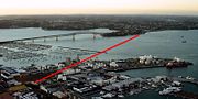
In December 2007, Transit New Zealand noted that the more than 160 options had been narrowed down to only two alignments. The first possible alignment (of approximately 4.5 km length) would be a parallel link several hundred meters directly to the east of the existing bridge (either as a bridge or a tunnel), while the second alignment (of approximately 6.5 km length) would start in the same general environs in North Shore City, but travel diagonally southeastwards to link up with the motorway at Grafton Gully
Grafton Gully
Grafton Gully is a deep and very wide gully cutting northwards through the volcanic hills of the Auckland Volcanic Field in Auckland, New Zealand. It divides the CBD of the city from the suburbs of Grafton and Parnell in the east.Grafton Gully is crossed by Grafton Bridge near its south end...
, east of the Auckland CBD. The second option, due to the need to cross shipping lanes, would need to be a tunnel. It could also possibly be connected to the CBD via a side branch tunnel (for use by public transport only). North Shore City has noted that it would prefer a tunnel option for aesthetic reasons, and to potentially emplace light rail within the tunnel at a future stage.
A tunnel had been proposed as early as 1920, during discussions about extension of Auckland's rail network.
Recommended option
In mid-2008, the Waitemata Harbour Crossing study group released their recommended option (2C), which would connect from the existing Esmonde and Onewa motorway interchanges on the North Shore City side to Auckland City, reaching land in the southwestern part of the Western Reclamation (though the links may continue as tunnels for some further distance, likely going under Victoria Park). The option selected from several hundred considered alignments foresees four separate tunnels, two for motor vehicles and two for public transport. Due to the reduced costs of narrow-diameter tunnels driven by modern tunneling methods compared to providing similar capacity in one or more large tunnels, this option was considered the most economic. The characteristics of the recommended options are:- two motorway tunnels (three lanes northbound in one tunnel, three lanes southbound in the other), carrying State Highway 1
- two public transport tunnels (rail in the recommended option), connecting BritomartBritomart Transport CentreBritomart Transport Centre is the CBD public transport hub of Auckland, New Zealand, and the northern terminus of the North Island Main Trunk line. It combines a bus interchange with a railway station in a former Edwardian post office, extended with expansive post-modernist architectural elements...
with a new North Shore City rail system - demolition of the Victoria Park ViaductVictoria Park ViaductThe Victoria Park Viaduct is a major motorway viaduct carrying the Auckland Northern Motorway over the Victoria Park area in Auckland City, New Zealand...
and deemphasising of the Auckland Harbour Bridge for some through routes - provision of a new rail station for the future Wynyard QuarterWestern ReclamationThe Wynyard Quarter is a reclaimed piece of land on the Waitemata Harbour at the western edge of the Auckland waterfront, New Zealand....
at the southern edge of the new development - an estimated cost of NZ$3.7 to NZ$4.1 billion, though the links could be built in stages, reducing immediate costs
The study also assumes that by 2041, the volume of trips over the harbour will increase by 80% from current (2000s) levels, and estimate that the public transport share on the link would rise from a current 15% to then 30%.
In mid 2009, NZTA was reported to be preparing land designation
Designation
Designation may refer to:* Professional certification* Designation , an official classification determined by a government agency or historical society- See also :* United States Department of Defense aerospace vehicle designation...
s for the tunnel option, to safeguard the route and ensure progress on the Western Reclamation
Western Reclamation
The Wynyard Quarter is a reclaimed piece of land on the Waitemata Harbour at the western edge of the Auckland waterfront, New Zealand....
did not negatively affect the future tunnel and vice versa. Transport and Associate Infrastructure Minister Steven Joyce
Steven Joyce
Steven Leonard Joyce is a New Zealand politician, who entered the New Zealand House of Representatives in 2008 as a member of the New Zealand National Party...
also noted that a decision would be made in 2009 as to whether the crossing would be included in NZTA's new 20 year plan. On 2 December 2009, NZTA announced that designations would be protected for the four-tube tunnel option, though funding to build them was not currently allocated in the budgets, and no future date for construction was announced.
Bridge alternative
During the public discussions in 2007, an interest group also put forward a proposal to build a new, much larger bridge to the east of the existing structure, and demolish the old Harbour Bridge. They argue that the new bridge, which would be about 50% longer than the existing one, could be constructed to provide for dedicated public transport (including light rail, which is credited with allowing a tripling of the total capacity in people moved over the existing Harbour Bridge), as well as for cyclists and pedestrians. Significantly, they argue that the new bridge would more or less pay for itself, by freeing up new residential land (currently taken up by several km of motorway approaches) in some of the most sought-after Auckland locations like Saint Marys BaySaint Marys Bay, New Zealand
Saint Marys Bay is an Auckland suburb- 1800s :mid-1840s George Scott farms the land where 3 Lamps is now.1853 For £1100 Catholic Bishop Pompallier purchases 19ha in the area between 3 lamps and the shoreline from James O’Neill christening it Mount St. Mary.1854 O’Neill’s house becomes St. Anne’s...
. The proponents claim that the bridge would free up more than 35 hectares and open up 3.3 km of shoreline, a prize which would more than make up for the fact that the plans for the Western Reclamation
Western Reclamation
The Wynyard Quarter is a reclaimed piece of land on the Waitemata Harbour at the western edge of the Auckland waterfront, New Zealand....
redevelopment would in this case find themselves partly compromised by a major motorway in its area. The new bridge would also be cheaper to operate and would not need emission vents like a tunnel.
The new bridge design, a cantilever spar cable-stayed bridge
Cantilever spar cable-stayed bridge
A cantilever spar cable-stayed bridge is a modern variation of the cable-stayed bridge. This design has been pioneered by the architect Santiago Calatrava. An example of this type is the Puente del Alamillo...
, was proposed by the Jasmax architectural firm, which note the 'Anzac Centenary Bridge' would be buildable in time for the 100-year memorial of the Gallipoli landings
Battle of Gallipoli
The Gallipoli Campaign, also known as the Dardanelles Campaign or the Battle of Gallipoli, took place at the peninsula of Gallipoli in the Ottoman Empire between 25 April 1915 and 9 January 1916, during the First World War...
in 1915.
Some attendees at a 2009 bridge conference held by the NZTA
New Zealand Transport Agency
The New Zealand Transport Agency is a New Zealand Crown entity tasked with promoting safe and functional transport by land, including the responsibility for driver and vehicle licensing and investigating rail accidents. It was created on 1 August 2008 by the Land Transport Management Amendment...
in Auckland have remarked that a bridge would be more beneficial to Auckland in some ways, and have reduced operating costs compared to a tunnel solution.
In October 2009, the bridge option again surfaced in the public eye, with a group of backers again suggesting that a bridge would be a better option from an urban design, and even from a transport point of view. Critics note that the proposal would delay other transport plans in the region due to the funding required for it, especiallyfor a 2015 target. The mayor of North Shore, Andrew Williams, and the Chairman of the Auckland Regional Council, Mike Lee
Mike Lee (New Zealand politician)
Michael Lee is a councillor on the Auckland Council and the former chairman of the Auckland Regional Council, both in Auckland, New Zealand...
, both oppose reconsidering existing decisions in favour of a tunnel. Auckland City mayor John Banks also noted that he favours the tunnel option, though he does not outright oppose the bridge idea, while Manukau City mayor Len Brown considered the bridge proposal as worthy of consideration.
The more detailed concept the bridge group proposed in late 2009 would include eight traffic lanes (including separate truck and bus lanes), two light rail tracks (in the bridge deck) as well as walking and cycling paths, possibly with travelator
Moving walkway
A moving walkway or moving sidewalk is a slow moving conveyor mechanism that transports people, across a horizontal...
s. Backers are claiming that the bridge, estimated by them at NZ$2-3 billion, would be significantly cheaper than a tunnel for approximately NZ$4 billion.
In December 2009, it was announced by NZTA that designations would be sought for the tunnel options, though it was noted that this did not have to preclude a future bridge option, but was solely an exercise to protect the tunnel possibilities against conflict with future development in the Western Reclamation
Western Reclamation
The Wynyard Quarter is a reclaimed piece of land on the Waitemata Harbour at the western edge of the Auckland waterfront, New Zealand....
area. The lobby group for the bridge option considers the fact that the transport minister did not preclude it as a success, though their original timeframe was also modified, now aiming for a construction start (rather than finish) by 2015. In March 2010, tendering for a new study was announced, after Steven Joyce
Steven Joyce
Steven Leonard Joyce is a New Zealand politician, who entered the New Zealand House of Representatives in 2008 as a member of the New Zealand National Party...
apparently instructed NZTA to reopen the bridge/tunnel debate. The decision of the minister was criticised by an editorial in The New Zealand Herald for wasting time and money, since the previous study had already, at cost of over $1 million, conclusively ruled out a bridge as a good solution.
Other modes
Plans intend that with the construction of the new motorway links via the second crossing, capacity on the existing bridge be freed up for walking and cycling links. However, advocacy groups have noted that any second crossing would not be built for possibly decades to come, if at all, and thus should not detract from providing the links sooner.See also
General:- Public transport in AucklandPublic transport in AucklandPublic transport in Auckland, the largest metropolitan area of New Zealand, consists of three modes – bus, train and ferry. Services are provided under the "MAXX" brand by private transport providers, coordinated by Auckland Transport, the council controlled organisation that replaced the Auckland...
- Transport in AucklandTransport in AucklandTransport in Auckland, New Zealand's largest city, is defined by various factors, among them the shape of the Auckland isthmus , the suburban character of much of the Auckland area and the large car-ownership ratio of New Zealanders.These factors have resulted in a mostly...
Specific:
- Central Motorway JunctionCentral Motorway JunctionThe Central Motorway Junction or CMJ , is the intersection of New Zealand State Highways 1 and 16, just south of the central business district of Auckland, New Zealand...
, the major motorway junction connecting southeast of the bridge - Newmarket ViaductNewmarket ViaductThe Newmarket Viaduct, sometimes considered 'one of the most distinctive engineering features' of New Zealand, is a six-lane State highway viaduct in Auckland, the country's largest city. Carrying the Southern Motorway over the Newmarket suburb area southeast of the CBD of the city, the 700 m long...
, similarly important traffic bottleneck on other side of Auckland CBD - Western ReclamationWestern ReclamationThe Wynyard Quarter is a reclaimed piece of land on the Waitemata Harbour at the western edge of the Auckland waterfront, New Zealand....
, large industrial area east of the bridge, possible site of 2nd crossing