

Scotchmans Creek Trail
Encyclopedia
The Scotchmans Creek Trail is a shared use path for cyclists
and pedestrian
s, which follows Scotchmans Creek through the eastern suburbs of Melbourne
, Victoria
, Australia
.
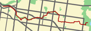
It runs from East Malvern railway station through to Jells Park
although several sections consist of normal residential streets. The trail provides good access to Chadstone Shopping Centre
and Holmesglen Institute of TAFE for the local community. The Valley Reserve in Mount Waverley, that the trail runs through, is acknowledged as being one of the last remaining stands of indigenous vegetation in the local area.
Although Scotchmans Creek Trail is widely recognized as ending in the west atEast Malvern Railway Station, some sources have the trail's west end at Warrigal Rd.
 The trail begins in the west at East Malvern Railway Station where it runs alongside the Monash Freeway
until it meets Warrigal Road. An overpass takes it to Scotchmans Creek where it continues along the Scotchmans Creek Linear Reserve until it reaches Park Rd. It passes to the north of the Oakleigh Recreation Centre and onwards to Huntingdale Rd where pedestrian lights allow safe crossing. Past the Huntingdale Wetlands it crosses Stanley St before going in a tunnel under the Monash Freeway and then under Stephensons Rd. After crossing Forster Rd the path leaves Scotchmans Creek requiring cyclists to travel on residential streets (see map of the route to take). Rhonda St and Anthony Drv lead to Waverley Rd where it rejoins the path along Scotchmans Creek. The shared use path finally ends at Waverley Rd with most of the remaining journey to Jells Park
being on residential streets.
After crossing Waverley Rd, turn down Ivanhoe St and follow the path East to Winmalee Dr turn down Koonalda Ave and cross over Springvale Rd at the pedestrian lights (see map of the route to take). A road section section at Whites Lane leads to a tennis club. Leave the road for the path at this point. The turn off is very easy to miss. The path continues to Belvedere Ave, Mackintosh Rd and Lum Rd.
There are two options after Lum Rd - either go down Strickland Dr and Clarke Ct or Tom Begg Ct. The trail is steep here as it descends into the Dandenong Valley. A short lane way at the end of each court leads to Sunnybrook Drv. The final section of the path continues to Jells Park
(see map of the route to take).
Note the footbridge over the Monash Freeway
was reopened on the 20th August 2009.
West end at 37.872810°S 145.068955°E.
East end at 37.901598°S 145.201331°E.
Cycling
Cycling, also called bicycling or biking, is the use of bicycles for transport, recreation, or for sport. Persons engaged in cycling are cyclists or bicyclists...
and pedestrian
Pedestrian
A pedestrian is a person traveling on foot, whether walking or running. In some communities, those traveling using roller skates or skateboards are also considered to be pedestrians. In modern times, the term mostly refers to someone walking on a road or footpath, but this was not the case...
s, which follows Scotchmans Creek through the eastern suburbs of Melbourne
Melbourne
Melbourne is the capital and most populous city in the state of Victoria, and the second most populous city in Australia. The Melbourne City Centre is the hub of the greater metropolitan area and the Census statistical division—of which "Melbourne" is the common name. As of June 2009, the greater...
, Victoria
Victoria (Australia)
Victoria is the second most populous state in Australia. Geographically the smallest mainland state, Victoria is bordered by New South Wales, South Australia, and Tasmania on Boundary Islet to the north, west and south respectively....
, Australia
Australia
Australia , officially the Commonwealth of Australia, is a country in the Southern Hemisphere comprising the mainland of the Australian continent, the island of Tasmania, and numerous smaller islands in the Indian and Pacific Oceans. It is the world's sixth-largest country by total area...
.
It runs from East Malvern railway station through to Jells Park
Jells Park
Jells Park is a public park in Wheelers Hill, a suburb to the south-east of Melbourne, Victoria, Australia. Opening on 30 April 1976, the park attracts in excess of 700,000 visitors a year. The park is in excess of 127 hectares and contains 9 kilometres of bike paths. The Dandenong Creek Trail runs...
although several sections consist of normal residential streets. The trail provides good access to Chadstone Shopping Centre
Chadstone Shopping Centre
Chadstone Shopping Centre is a super regional shopping centre located in the inner south-eastern suburb of Malvern East in the city of Melbourne, Australia...
and Holmesglen Institute of TAFE for the local community. The Valley Reserve in Mount Waverley, that the trail runs through, is acknowledged as being one of the last remaining stands of indigenous vegetation in the local area.
Although Scotchmans Creek Trail is widely recognized as ending in the west atEast Malvern Railway Station, some sources have the trail's west end at Warrigal Rd.
Following the Path
Monash Freeway
Monash Freeway is an urban freeway in Victoria, Australia linking Melbourne's CBD to its southeastern suburbs and the Gippsland region. The entire stretch of the Monash Freeway bears the designation...
until it meets Warrigal Road. An overpass takes it to Scotchmans Creek where it continues along the Scotchmans Creek Linear Reserve until it reaches Park Rd. It passes to the north of the Oakleigh Recreation Centre and onwards to Huntingdale Rd where pedestrian lights allow safe crossing. Past the Huntingdale Wetlands it crosses Stanley St before going in a tunnel under the Monash Freeway and then under Stephensons Rd. After crossing Forster Rd the path leaves Scotchmans Creek requiring cyclists to travel on residential streets (see map of the route to take). Rhonda St and Anthony Drv lead to Waverley Rd where it rejoins the path along Scotchmans Creek. The shared use path finally ends at Waverley Rd with most of the remaining journey to Jells Park
Jells Park
Jells Park is a public park in Wheelers Hill, a suburb to the south-east of Melbourne, Victoria, Australia. Opening on 30 April 1976, the park attracts in excess of 700,000 visitors a year. The park is in excess of 127 hectares and contains 9 kilometres of bike paths. The Dandenong Creek Trail runs...
being on residential streets.
After crossing Waverley Rd, turn down Ivanhoe St and follow the path East to Winmalee Dr turn down Koonalda Ave and cross over Springvale Rd at the pedestrian lights (see map of the route to take). A road section section at Whites Lane leads to a tennis club. Leave the road for the path at this point. The turn off is very easy to miss. The path continues to Belvedere Ave, Mackintosh Rd and Lum Rd.
There are two options after Lum Rd - either go down Strickland Dr and Clarke Ct or Tom Begg Ct. The trail is steep here as it descends into the Dandenong Valley. A short lane way at the end of each court leads to Sunnybrook Drv. The final section of the path continues to Jells Park
Jells Park
Jells Park is a public park in Wheelers Hill, a suburb to the south-east of Melbourne, Victoria, Australia. Opening on 30 April 1976, the park attracts in excess of 700,000 visitors a year. The park is in excess of 127 hectares and contains 9 kilometres of bike paths. The Dandenong Creek Trail runs...
(see map of the route to take).
Connections
- Scotchmans Creek Trail connects at the west end to Gardiners Creek TrailGardiners Creek TrailThe Gardiners Creek Trail is a shared use path for cyclists and pedestrians, which follows Gardiners Creek through the eastern suburbs of Melbourne, Victoria, Australia....
and Outer Circle TrailOuter Circle TrailThe Outer Circle Trail, also known as the Anniversary Trail, Anniversary Outer Circle Trail, or even the Outer Circle Anniversary Trail, is a shared use path for cyclists and pedestrians, which partly follows the Alamein Line through the inner eastern suburbs of Melbourne, Victoria, Australia.The...
and East Malvern Station to Centre Rd TrailEast Malvern Station to Centre Rd TrailThe Station Trail is a shared use path for cyclists and pedestrians, which follows the Pakenham/Cranbourne railway lines from Hughesdale railway station to Centre Road, Clayton in the inner southern suburbs of Melbourne, Victoria, Australia....
.
- The Waverley Rail TrailWaverley Rail TrailThe Waverley Rail Trail is a combination of shared use path for cyclists and pedestrians and on-road bicycle route, which follows the Glen Waverley railway line from Holmesglen railway station to Glen Waverley railway station in the south eastern suburbs of Melbourne, Victoria, Australia.-...
can be reached via Argyll St (1km). At Waverley Rd pass under the highway using the path that leads to Golfers Drv. Heading towards the public golf course, the path resumes on the right. Descending down the path then leads to Argyll St. Travel east to the far end of Argyll St. At Holmesglen railway station use the pedestrian bridge to cross Warrigal Road arriving at the Waverley Rail TrailWaverley Rail TrailThe Waverley Rail Trail is a combination of shared use path for cyclists and pedestrians and on-road bicycle route, which follows the Glen Waverley railway line from Holmesglen railway station to Glen Waverley railway station in the south eastern suburbs of Melbourne, Victoria, Australia.-...
.
- At the east end at Jells ParkJells ParkJells Park is a public park in Wheelers Hill, a suburb to the south-east of Melbourne, Victoria, Australia. Opening on 30 April 1976, the park attracts in excess of 700,000 visitors a year. The park is in excess of 127 hectares and contains 9 kilometres of bike paths. The Dandenong Creek Trail runs...
it links to the Dandenong Creek TrailDandenong Creek TrailThe Dandenong Creek Trail is a shared use path for cyclists and pedestrians, which follows Dandenong Creek through the outer eastern and south-eastern suburbs of Melbourne, Victoria, Australia.-Following the Path:...
. The Blind Creek TrailBlind Creek TrailThe Blind Creek Trail is a shared-use path for cyclists and pedestrians, which follows the Blind Creek from the Dandenong Creek Trail in Wantirna South to the Ringwood - Belgrave Rail Trail in Boronia, in the outer eastern suburbs of Melbourne, Victoria, Australia.This trail is one of the major...
also terminates near the north end of Jells ParkJells ParkJells Park is a public park in Wheelers Hill, a suburb to the south-east of Melbourne, Victoria, Australia. Opening on 30 April 1976, the park attracts in excess of 700,000 visitors a year. The park is in excess of 127 hectares and contains 9 kilometres of bike paths. The Dandenong Creek Trail runs...
.
- A short road section (Blackburn Rd, Falconer St & Flander Ave) leads to Syndal station. On the north side of the station, in Shirley Ave, is the southern end of the Syndal Heatherdale Pipe Reserve TrailSyndal Heatherdale Pipe Reserve TrailThe Syndal Heatherdale Pipe Reserve Trail is a shared use path for cyclists and pedestrians, which follows the Syndal to Heatherdale pipe reserve in the eastern suburbs of Melbourne, Victoria, Australia....
.
Note the footbridge over the Monash Freeway
Monash Freeway
Monash Freeway is an urban freeway in Victoria, Australia linking Melbourne's CBD to its southeastern suburbs and the Gippsland region. The entire stretch of the Monash Freeway bears the designation...
was reopened on the 20th August 2009.
West end at 37.872810°S 145.068955°E.
East end at 37.901598°S 145.201331°E.