

Savanes Region, Togo
Encyclopedia

Regions of Togo
||Togo is divided into five regions :*Centrale *Kara *Maritime *Plateaux *Savanes The regions are divided into 30 prefectures and 1 commune.-See also:...
of Togo
Togo
Togo, officially the Togolese Republic , is a country in West Africa bordered by Ghana to the west, Benin to the east and Burkina Faso to the north. It extends south to the Gulf of Guinea, on which the capital Lomé is located. Togo covers an area of approximately with a population of approximately...
. Dapaong
Dapaong
Dapaong is a city in northern Togo and prefecture seat of Tône in the Savanes Region. It is situated 638 km north of the capital Lomé, near the border with Burkina Faso. It is a market town and has a small museum....
is the regional capital. Another major town in the region is Mango
Mango (Togo)
Mango or Sansanné-Mango is a city in Togo. It is situated in the Savanes Region, 26 km from the border with Ghana. The population is about 41,464 people ....
.
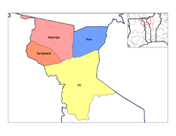
Savanes is divided into the prefectures of Kpendjal
Kpendjal
Kpendjal is a prefecture located in the Savanes Region of Togo. The prefecture seat is located in Mandouri.In the far northwest of Kpendjal is a long, thin strip along the border with Burkina Faso that includes Togo's farthest north and farthest west points. In this area is also Togo's only border...
, Oti
Oti, Togo
Oti is a prefecture located in the Savanes Region of Togo. The prefecture seat is located in Sansanné-Mango....
, Tandjouaré
Tandjouaré
Tandjouaré is a prefecture located in the Savanes Region of Togo. The seat is Tandjouaré....
, and Tône
Tône
Tône is a prefecture located in the Savanes Region of Togo. The prefecture seat is located in Dapaong....
.
To the south of Savanes is Kara Region
Kara Region
Kara is one of Togo's five regions. Kara is the regional capital.Other major cities in the Kara region include Bafilo, Bassar, and Niamtougou.Kara is divided into the prefectures of Assoli, Bassar, Bimah, Dankpen, Doufelgou, Kéran, and Kozah....
, its only domestic border. It shares borders with the following foreign areas:
- Northern RegionNorthern Region (Ghana)The Northern Region is the largest area of Ghana. As of 2009, it is divided into 20 districts. The region's capital is Tamale. Climatically, religiously, linguistically, and culturally, the region differs greatly from the politically and economically dominating regions of central and southern...
, GhanaGhanaGhana , officially the Republic of Ghana, is a country located in West Africa. It is bordered by Côte d'Ivoire to the west, Burkina Faso to the north, Togo to the east, and the Gulf of Guinea to the south...
: southwest - Upper East RegionUpper East RegionThe Upper East Region is the smallest of 10 administrative regions in Ghana, occupying a total land surface of 8,842 square kilometers or 2.7 per cent of the total land area of Ghana. In terms of population, it is the ninth most populated region with a population of 920,089 in 2000, accounting for...
, GhanaGhanaGhana , officially the Republic of Ghana, is a country located in West Africa. It is bordered by Côte d'Ivoire to the west, Burkina Faso to the north, Togo to the east, and the Gulf of Guinea to the south...
: west - Boulgou Province, Burkina FasoBurkina FasoBurkina Faso – also known by its short-form name Burkina – is a landlocked country in west Africa. It is surrounded by six countries: Mali to the north, Niger to the east, Benin to the southeast, Togo and Ghana to the south, and Côte d'Ivoire to the southwest.Its size is with an estimated...
: far northwest - Koulpélogo Province, Burkina FasoBurkina FasoBurkina Faso – also known by its short-form name Burkina – is a landlocked country in west Africa. It is surrounded by six countries: Mali to the north, Niger to the east, Benin to the southeast, Togo and Ghana to the south, and Côte d'Ivoire to the southwest.Its size is with an estimated...
: northwest - Kompienga Province, Burkina FasoBurkina FasoBurkina Faso – also known by its short-form name Burkina – is a landlocked country in west Africa. It is surrounded by six countries: Mali to the north, Niger to the east, Benin to the southeast, Togo and Ghana to the south, and Côte d'Ivoire to the southwest.Its size is with an estimated...
: northeast - Atakora DepartmentAtakora DepartmentAtakora is the northwestern department of Benin, bordering Togo to the west and Burkina Faso to the north. Also, it borders the departments of Alibori, Borgou, and Donga. It is the most mountainous region of Benin, and the birth place of the president, Mathieu Kérékou...
, BeninBeninBenin , officially the Republic of Benin, is a country in West Africa. It borders Togo to the west, Nigeria to the east and Burkina Faso and Niger to the north. Its small southern coastline on the Bight of Benin is where a majority of the population is located...
: east
Savanes is the only region that borders Burkina Faso
Burkina Faso
Burkina Faso – also known by its short-form name Burkina – is a landlocked country in west Africa. It is surrounded by six countries: Mali to the north, Niger to the east, Benin to the southeast, Togo and Ghana to the south, and Côte d'Ivoire to the southwest.Its size is with an estimated...
.