

Sauratown Mountains
Encyclopedia
Mountain range
A mountain range is a single, large mass consisting of a succession of mountains or narrowly spaced mountain ridges, with or without peaks, closely related in position, direction, formation, and age; a component part of a mountain system or of a mountain chain...
located within Stokes and Surry counties in the U.S. state
U.S. state
A U.S. state is any one of the 50 federated states of the United States of America that share sovereignty with the federal government. Because of this shared sovereignty, an American is a citizen both of the federal entity and of his or her state of domicile. Four states use the official title of...
of North Carolina
North Carolina
North Carolina is a state located in the southeastern United States. The state borders South Carolina and Georgia to the south, Tennessee to the west and Virginia to the north. North Carolina contains 100 counties. Its capital is Raleigh, and its largest city is Charlotte...
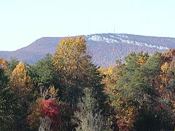
. The vast majority of the range is located in Stokes County, and even though the range occupies only 5% of Stokes County's area, they dominate the county's scenery from almost every direction. The range rises sharply 800 to 1,700 feet (244 to 518 meters) above the surrounding terrain. The Sauratown Mountains were named after the "Saura
Saura
The Saura were a tribe of Native Americans who lived in the Piedmont area of North Carolina near the Sauratown Mountains, east of Pilot Mountain and north of the Yadkin River. They were believed to have spoken a Siouan language....
s", a Native American tribe which lived in the area before European settlers arrived in the early 1700s. The range consists of rugged, heavily forest
Forest
A forest, also referred to as a wood or the woods, is an area with a high density of trees. As with cities, depending where you are in the world, what is considered a forest may vary significantly in size and have various classification according to how and what of the forest is composed...
ed ridges frequently broken by large quartzite
Quartzite
Quartzite is a hard metamorphic rock which was originally sandstone. Sandstone is converted into quartzite through heating and pressure usually related to tectonic compression within orogenic belts. Pure quartzite is usually white to gray, though quartzites often occur in various shades of pink...
rock cliffs which can be seen for miles. The Sauratown Mountains are known for offering some of the best rock climbing in North Carolina. The highest point in the Sauratown Mountains is Moore's Knob
Moore's Knob
Moore's Knob is the highest mountain in the Sauratown Mountains of Stokes County, North Carolina. The Sauratown Mountains are an isolated remnant of the much larger Blue Ridge Mountains far to the west and north. A rugged, deeply eroded range, the Sauras feature dramatic rock cliffs which can be...
, which rises to 2,579 feet (786 m).
The range is home to Hanging Rock State Park
Hanging Rock State Park
Hanging Rock State Park is a North Carolina state park in Stokes County, North Carolina in the United States. The park is north of Winston-Salem and is located approximately from Danbury in Stokes County.-History:...
, which was formed in 1936 and contains Moore's Knob and other prominent peaks in the Sauratown Mountains. From 1935 to 1942 the Civilian Conservation Corps
Civilian Conservation Corps
The Civilian Conservation Corps was a public work relief program that operated from 1933 to 1942 in the United States for unemployed, unmarried men from relief families, ages 18–25. A part of the New Deal of President Franklin D...
, a New Deal
New Deal
The New Deal was a series of economic programs implemented in the United States between 1933 and 1936. They were passed by the U.S. Congress during the first term of President Franklin D. Roosevelt. The programs were Roosevelt's responses to the Great Depression, and focused on what historians call...
agency, built a dam and 12 acres (48,562.3 m²) lake in the park, as well as hiking and climbing trails and picnic and campground areas.
Uniquely shaped Pilot Mountain
Pilot Mountain (North Carolina)
Pilot Mountain, a metamorphic quartzite monadnock rising to a peak above sea level, is one of the most distinctive natural features in the state of North Carolina. It is a remnant of the ancient chain of Sauratown Mountains. The Saura were the earliest known inhabitants of the region...
is also located in the range. Pilot Mountain State Park
Pilot Mountain State Park
Pilot Mountain State Park is a North Carolina state park in Surry and Yadkin Counties, North Carolina in the United States. Located near Pinnacle, North Carolina on highway US 52, it covers 3,703 acres and includes the distinctive 2,241 foot peak of Pilot Mountain.-History:The Saura, a...
encompasses the western most end of the range.
A hiking
Hiking
Hiking is an outdoor activity which consists of walking in natural environments, often in mountainous or other scenic terrain. People often hike on hiking trails. It is such a popular activity that there are numerous hiking organizations worldwide. The health benefits of different types of hiking...
and bridle trail, known as the Sauratown Trail
Sauratown Trail
Sauratown Trail is a hiking and bridle trail in Stokes and Surry counties, North Carolina, which crosses the Sauratown Mountains and interconnects Pilot Mountain State Park and Hanging Rock State Park. It is the only bridal trail which goes between two NC State Parks...
, crosses the range and interconnects the two state parks. The Mountains-to-Sea Trail
Mountains-to-Sea Trail
The Mountains-to-Sea Trail is a long-distance trail, for hiking and backpacking, that runs across North Carolina from the Great Smoky Mountains to the Outer Banks. The trail's western endpoint is at Clingman's Dome, where it connects to the Appalachian Trail in the Great Smoky Mountains National...
follows the Sauratown Trail, and it passes through both parks.
Peaks
| Peak name Summit (topography) In topography, a summit is a point on a surface that is higher in elevation than all points immediately adjacent to it. Mathematically, a summit is a local maximum in elevation... |
Elevation | Coordinates Geographic coordinate system A geographic coordinate system is a coordinate system that enables every location on the Earth to be specified by a set of numbers. The coordinates are often chosen such that one of the numbers represent vertical position, and two or three of the numbers represent horizontal position... |
Protected area Protected area Protected areas are locations which receive protection because of their recognised natural, ecological and/or cultural values. There are several kinds of protected areas, which vary by level of protection depending on the enabling laws of each country or the regulations of the international... |
County County A county is a jurisdiction of local government in certain modern nations. Historically in mainland Europe, the original French term, comté, and its equivalents in other languages denoted a jurisdiction under the sovereignty of a count A county is a jurisdiction of local government in certain... |
Remarks | ||||
|---|---|---|---|---|---|---|---|---|---|
| Stony Ridge | 1361 feet (414.8 m) | 36°17′36"N 80°30′14"W | Surry | The Corridor Trail is the closest access to the summit, but it does not go to the summit. | |||||
| Pilot Mountain Pilot Mountain (North Carolina) Pilot Mountain, a metamorphic quartzite monadnock rising to a peak above sea level, is one of the most distinctive natural features in the state of North Carolina. It is a remnant of the ancient chain of Sauratown Mountains. The Saura were the earliest known inhabitants of the region... |
2421 feet (737.9 m) | 36°20′24"N 80°28′27"W | Surry | The mountain's Saura Saura The Saura were a tribe of Native Americans who lived in the Piedmont area of North Carolina near the Sauratown Mountains, east of Pilot Mountain and north of the Yadkin River. They were believed to have spoken a Siouan language.... name is Jomeokee. The summit area is off limits to the general public, and it is only physically accessible via rock climbing Rock climbing Rock climbing also lightly called 'The Gravity Game', is a sport in which participants climb up, down or across natural rock formations or artificial rock walls. The goal is to reach the summit of a formation or the endpoint of a pre-defined route without falling... . The highest point people can get to in the park is the Little Pinnacle, a false summit. |
|||||
| Black Mountain | 1447 feet (441 m) | Privately owned | Surry | The small mountain is north-east of Pilot Mountain, near the county line. | |||||
| Sauratown Mountain | 2441 feet (744 m) | 36°22′28"N 80°22′17"W | Privately owned | Stokes | Due to being a major radio communications site, there is no public access to Sauratown Mountain. A gated, private road ends a short distance from the summit. | ||||
| Brown Mountain | 1550 feet (472.4 m) | 36°27′14"N 80°20′21"W | Privately owned | Stokes | The mountain is north of Sauratown Mountain. | ||||
| Ruben Mountain | 1817 feet (553.8 m) | 36°23′13"N 80°18′44"W | Stokes | Ruben is in between Sauratown Mountain and Hanging Rock. The Sauratown Loop Trail Sauratown Trail Sauratown Trail is a hiking and bridle trail in Stokes and Surry counties, North Carolina, which crosses the Sauratown Mountains and interconnects Pilot Mountain State Park and Hanging Rock State Park. It is the only bridal trail which goes between two NC State Parks... passes nearby the summit. |
|||||
| Devils Chimney | 2396 feet (730.3 m) | 36°22′52"N 80°17′29"W | Stokes | The Cook's Wall Trail ends near near the summit. | |||||
| Cooks Wall Mountain | 2346 feet (715.1 m) | 36°22′44"N 80°17′15"W | Stokes | The Cook's Wall Trail passes close by the summit. | |||||
| Moore's Knob Moore's Knob Moore's Knob is the highest mountain in the Sauratown Mountains of Stokes County, North Carolina. The Sauratown Mountains are an isolated remnant of the much larger Blue Ridge Mountains far to the west and north. A rugged, deeply eroded range, the Sauras feature dramatic rock cliffs which can be... |
2579 feet (786.1 m) | 36°23′53"N 80°16′58"W | Stokes | The highest point in the range. The Moore's Wall Loop Trail, a part of the Mountains-to-Sea Trail Mountains-to-Sea Trail The Mountains-to-Sea Trail is a long-distance trail, for hiking and backpacking, that runs across North Carolina from the Great Smoky Mountains to the Outer Banks. The trail's western endpoint is at Clingman's Dome, where it connects to the Appalachian Trail in the Great Smoky Mountains National... , provides access to an old fire tower on top of the knob. |
|||||
| Wolf Rock | 2024 feet (616.9 m) | 36°23′11"N 80°16′01"W | Stokes | The Wolf Rock Loop Trail crosses over this sub-summit. | |||||
| Hanging Rock Mountain | 2160 feet (658.4 m) † | Stokes | The Hanging Rock Trail makes the closest approach to the summit, but does not go to it. The trail ends at the Hanging Rock. | ||||||
| Flat Shoals Mountain | 1660 feet (506 m) † | 36°22′38"N 80°13′22"W | Stokes | There are no park trails on this mountain. | |||||
| † Approximate elevation. | |||||||||