
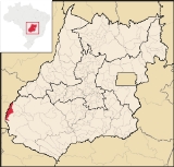
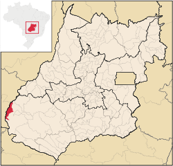
Santa Rita do Araguaia
Encyclopedia
| Santa Rita do Araguaia | |
|---|---|
| State | Goiás Goiás Goiás is a state of Brazil, located in the central part of the country. The name Goiás comes from the name of an indigenous community... |
| Area: | 1,361.7 km² |
| Population: | 5,873 (IBGE 2007) |
| Elevation: | 691m above sea level |
| Postcode (CEP): | 75840-000 |
| IBGE statistical microregion: | Sudoeste de Goiás |
| Became a city: | 1953 |
| Distance to Goiânia Goiânia -Climate:The city has a tropical wet and dry climate with an average temperature of . There's a wet season, from October to April, and a dry one, from May to September. Annual rainfall is around 1,520 mm.... : |
500 km. |
| Website: | none |
Town
A town is a human settlement larger than a village but smaller than a city. The size a settlement must be in order to be called a "town" varies considerably in different parts of the world, so that, for example, many American "small towns" seem to British people to be no more than villages, while...
and municipality
Municipality
A municipality is essentially an urban administrative division having corporate status and usually powers of self-government. It can also be used to mean the governing body of a municipality. A municipality is a general-purpose administrative subdivision, as opposed to a special-purpose district...
in southwestern Goiás
Goiás
Goiás is a state of Brazil, located in the central part of the country. The name Goiás comes from the name of an indigenous community...
state, Brazil
Brazil
Brazil , officially the Federative Republic of Brazil , is the largest country in South America. It is the world's fifth largest country, both by geographical area and by population with over 192 million people...
.
Location
Santa Rita is located on the Araguaia RiverAraguaia River
The Araguaia River or, in Portuguese, Rio Araguaia is one of the major rivers of Brazil, and the principal tributary of the Tocantins. It has a total length of approximately 2,627 km. Araguaia means "river of macaws" in the Tupi language....
and is connected to the state capital, Goiânia
Goiânia
-Climate:The city has a tropical wet and dry climate with an average temperature of . There's a wet season, from October to April, and a dry one, from May to September. Annual rainfall is around 1,520 mm....
by highway BR-364. It is 91 kilometers west of regional center, Mineiros
Mineiros
Mineiros is a city in the southwest of the state of Goiás, Brazil. Mineiros is the westernmost city in Goiás and a great producer of cattle, soybeans, and corn....
. The distance to state capital, Goiânia is 516 km. Highway connections are made from Goiânia by BR-060 / Abadia de Goiás
Abadia de Goiás
Abadia de Goiás is a small town and municipality in central Goiás state, Brazil, located on the western edge of the Goiânia metropolitan area.-Geographical Data:The distance to Goiânia is 27 km...
/ Guapó
Guapó
Guapó is a small town and municipality in central Goiás state, Brazil. The population was 13,586 and the total area of the municipality was 517.0 km² .Guapó is part of the Goiânia Microregion...
/ Indiara
Indiara
Indiara is a small city and municipality in central-south Goiás state, Brazil. Indiara is a large producer of soybeans and cotton.-Location:Indiara is located in the Vale do Rio dos Bois and has municipal boundaries with:*north: Palmeiras de Goiás...
/ Acreúna
Acreúna
Acreúna is a small city and municipality in western Goiás state, Brazil.-Location:Acreúna is located in the statistical micro-region of Vale do Rio dos Bois, southwest of the state capital, Goiânia, on BR-060, which links Goiânia with Rio Verde...
/ Rio Verde
Rio Verde, Goiás
Rio Verde is a city and municipality in the Brazilian state of Goiás. It is a fast-growing center and is the largest producer of grains in the state.-Location:...
/ Jataí
Jataí
Jataí is a municipality in southern Goiás state, Brazil. Its population was 88,048 in a total area of 7,174.2 km². Jataí is a major producer of agricultural products, including soybeans, rice, and corn. It has the largest herd of cattle in the state and is a large producer of poultry and...
/ GO-050 / BR-364 / Mineiros / BR-384. Sepin
Municipal boundaries are with:
- north and west: Mato GrossoMato GrossoMato Grosso is one of the states of Brazil, the third largest in area, located in the western part of the country.Neighboring states are Rondônia, Amazonas, Pará, Tocantins, Goiás and Mato Grosso do Sul. It also borders Bolivia to the southwest...
- south and west: Mineiros
History
The origin of Santa Rita do Araguaia, located on the right bank of the Rio Araguaia, opposite the city of Alto AraguaiaAlto Araguaia
Alto Araguaia is a city in the state of Mato Grosso in Brasil.- References :...
in Mato Grosso, was the Araguaia ranch, bought in 1854 by José Manoel Vilela. He reserved a large area for a settlement called Santa Rita dos Impossíveis. Later the name was changed to Santa Rita do Araguaia. In 1911 it became a district in the municipality of Mineiros. In 1943 the name was changed to "Ivapé", an Indigenous word meaning "road of fruit". In 1953 the town became a municipality with its present name.
Political and Demographic Information
- Mayor: Luzia Ferreira Costa e Santos (January 2005)
- City council: 09
- Eligible voters: 3,674 (2007)
- Population density: 4.31 inhab/km² (2005)
- Urban population: 5,146 (2007)
- Rural population: 727 (2007)
- Geometric Growth Rate: 2.07% for 2000/2007
Economic Information
The economy is based on subsistence agriculture, cattle raising, services, public administration, and small transformation industries.- Industrial units: 2 (2007)
- Commercial units: 64 (2007)
- Financial institutions: 01 branch of Bradesco S.A. (May/2006)
- Automobiles: 653 (2007)
- Cattle herd: 53,500 head (4,900 milk cows)
- Main crops: rice, sugarcane, bananas, corn (3,550 hectares), and soybeans (5,000).
Education (2006) and Health (2007)
- Schools: 5 with 1,737 students
- Higher education: none
- Adult literacy rate: 85.9% (2000) (national average was 86.4%)
- Hospitals: 0
- Hospital beds: 0
- Ambulatory clinics: 1
- Infant mortality rate: 20.02 (2000) (national average was 33.0)
Municipal Human Development Index
Human Development Index
The Human Development Index is a composite statistic used to rank countries by level of "human development" and separate "very high human development", "high human development", "medium human development", and "low human development" countries...
- MHDI: 0.756
- Ranking in the state: 65 out of 242 municipalities
- National ranking: 1706 out of 5507 municipalities
Data are from 2000
For the complete list see Frigoletto.com
See also
- List of municipalities in Goiás
- Microregions of Goiás