
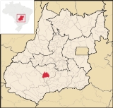
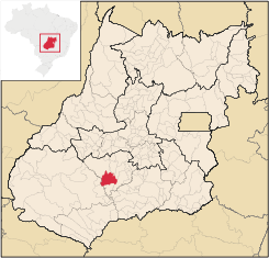
Acreúna
Encyclopedia
| Acreúna | |
|---|---|
| State | Goiás Goiás Goiás is a state of Brazil, located in the central part of the country. The name Goiás comes from the name of an indigenous community... |
| Area: | 1,571.1 km² |
| Population: | 18,553 (IBGE 2007) |
| Elevation: | 542m above sea level |
| Postal code (CEP): | 75960-000 |
| Became a city: | 1976 |
| Statistical Microregion: | Vale do Rio dos Bois |
| Distance to Goiânia Goiânia -Climate:The city has a tropical wet and dry climate with an average temperature of . There's a wet season, from October to April, and a dry one, from May to September. Annual rainfall is around 1,520 mm.... : |
153 km. |
| Website: | not available |
City
A city is a relatively large and permanent settlement. Although there is no agreement on how a city is distinguished from a town within general English language meanings, many cities have a particular administrative, legal, or historical status based on local law.For example, in the U.S...
and municipality
Municipality
A municipality is essentially an urban administrative division having corporate status and usually powers of self-government. It can also be used to mean the governing body of a municipality. A municipality is a general-purpose administrative subdivision, as opposed to a special-purpose district...
in western Goiás
Goiás
Goiás is a state of Brazil, located in the central part of the country. The name Goiás comes from the name of an indigenous community...
state, Brazil
Brazil
Brazil , officially the Federative Republic of Brazil , is the largest country in South America. It is the world's fifth largest country, both by geographical area and by population with over 192 million people...
.
Location
Acreúna is located in the statistical micro-region of Vale do Rio dos Bois, southwest of the state capital, GoiâniaGoiânia
-Climate:The city has a tropical wet and dry climate with an average temperature of . There's a wet season, from October to April, and a dry one, from May to September. Annual rainfall is around 1,520 mm....
, on BR-060, (Brasília
Brasília
Brasília is the capital city of Brazil. The name is commonly spelled Brasilia in English. The city and its District are located in the Central-West region of the country, along a plateau known as Planalto Central. It has a population of about 2,557,000 as of the 2008 IBGE estimate, making it the...
-Acre
Acre
The acre is a unit of area in a number of different systems, including the imperial and U.S. customary systems. The most commonly used acres today are the international acre and, in the United States, the survey acre. The most common use of the acre is to measure tracts of land.The acre is related...
) which links Goiânia with Rio Verde
Rio Verde
Rio Verde can mean the following:-Brazil:* Rio Verde, Goiás* Lucas do Rio Verde* Conceição do Rio Verde* Rio Verde de Mato Grosso-Brazil:29 rivers including:* Verde River...
. The distance to Goiânia
Goiânia
-Climate:The city has a tropical wet and dry climate with an average temperature of . There's a wet season, from October to April, and a dry one, from May to September. Annual rainfall is around 1,520 mm....
is 153 kilometers via BR-060 / Guapó
Guapó
Guapó is a small town and municipality in central Goiás state, Brazil. The population was 13,586 and the total area of the municipality was 517.0 km² .Guapó is part of the Goiânia Microregion...
/ Indiara
Indiara
Indiara is a small city and municipality in central-south Goiás state, Brazil. Indiara is a large producer of soybeans and cotton.-Location:Indiara is located in the Vale do Rio dos Bois and has municipal boundaries with:*north: Palmeiras de Goiás...
.
Municipal boundaries:
- North: ParaúnaParaúnaParaúna is a small town and municipality in southwestern Goiás state, Brazil. It has strange rock formations and is a large producer of cotton and soybeans.-Location:...
and JandaiaJandaiaJandaia is a small town and municipality in the eastern portion of the Brazilian state of Goiás.-Location and connections:Jandaia has municipal boundaries with:*Northwest: Palmeiras de Goiás*Northeast: Palminópolis... - South: TurvelândiaTurvelândiaTurvelândia is a small town and municipality in eastern Goiás state, Brazil.-Location:Turvelândia is located 65 km. east of Rio Verde*Highway connections from Goiânia are made by state highway BR-060 west from Goiânia, through / Abadia de Goiás / Guapó / Indiara / Acreúna/ GO-164 / Santa Helena...
- East: EdéiaEdéiaEdéia is a small city and municipality in south-central Goiás state, Brazil.-Municipal Boundaries:Edéia is in the Vale do Rio dos Boisstatistical micro-region and has municipal boundaries with:*north: Indiara*west: Acreúna and Turvelândia...
and IndiaraIndiaraIndiara is a small city and municipality in central-south Goiás state, Brazil. Indiara is a large producer of soybeans and cotton.-Location:Indiara is located in the Vale do Rio dos Bois and has municipal boundaries with:*north: Palmeiras de Goiás... - West: MontividiuMontividiuthumb|right|250px|Coordinates: Montividiu is a small town and municipality in eastern Goiás state, Brazil. Montividiu is a large producer of soybeans and corn.-Location and Neighboring Municipalities:...
and Santo Antônio da BarraSanto Antônio da BarraSanto Antônio da Barra is a municipality in southwest Goiás state, Brazil. The population was 4,544 in a total area of 451.6 km². The elevation of the municipal seat is 650 meters. Santo Antônio is a large producer of poultry....
History
The town appeared in 1964 in the territory of the municipality of ParaúnaParaúna
Paraúna is a small town and municipality in southwestern Goiás state, Brazil. It has strange rock formations and is a large producer of cotton and soybeans.-Location:...
. It was created through the initiative of Benedicto Arystogogo de Mello, who had already founded the settlements of Riverlândia, in Rio Verde
Rio Verde, Goiás
Rio Verde is a city and municipality in the Brazilian state of Goiás. It is a fast-growing center and is the largest producer of grains in the state.-Location:...
, and Vila Brasil, in Santa Helena de Goiás
Santa Helena de Goiás
Santa Helena de Goiás is a small city and municipality in southwestern Goiás state, Brazil. It is a large producer of corn, sugarcane, soybeans, and poultry.-Location:...
.
Mello negotiated with a large landowner of the region to begin selling the lots. The lands were on the banks of the Rio Verdão and near the Brasília – Acre highway, which was under construction at the time.
Origin of the name
The name of the town, Acreúna, comes from a combination of Acre, final destination of the highway which crosses the town, and Una, a tribute to Paraúna, the municipality where it had been located before becoming a separate municipality.
It became a district in 1968 and, thanks to its rapid population growth and economic development, it separated from Paraúna in 1976 to become an independent municipality.
Demographic and Political Data
- Population density: 11.85 inhabitants/km² (2007)
- Growth rate 2000/2007: 0.20.%
- Urban population: 16,424 inhab. (2007)
- Rural population: 2,129 inhab. (2007)
- Eligible voters: 14,790
- City government in 2005: mayor (João Batista Pereira), vice-mayor (Paulo Rogério Pereira), and 09 councilmembers
The economy
The economy is based on agriculture, with a great production of sugarcane, cotton, corn, and soybeans (see below). The cattle herd had 99,000 head in 2003.- Industrial units: 36
- Retail commercial units: 213
- Banking units: Banco do Brasil S.A.- BRADESCO S.A.- Banco Itaú S.A. (August/2007)
- GDP (PIB) (R$ 1,000.00): 229,685 (2005)
- GDP per capits (R$ 1.00): 10,959 (2005)
Vehicles (2007)
- automobiles: 1,862
- trucks: 317
- pickups: 413
- motorcycles: 1,001
Source: IBGE
The main agricultural products (2007)
- cotton: 2,000 ha. / 5,200 tons (Acreuna produced 55,000 tons in 2001)
- sugarcane: 5,700 hectares / 501,600 tons
- corn: 10,000 hectares / 60,000 tons
- soybeans: 22,000 hectares / 61,600 tons
Source: Sepin
Farm information
- Number of farms: 434
- Total farm area: 141,236
- Planted area: 51,300 ha.
- Area of natural pasture: 65,990 ha.
- Workers in agriculture: 1,042
Health
- Infant mortality rate in 2000: 21.13
- Infant mortality rate in 1990: 35.64
- Hospitals: 03 with 75 beds (2007)
Education
- Literacy rate in 2000: 83.2
- Literacy rate in 1991: 77.1
- Schools: 12 with 6,309 students (2006)
- Higher education: none reporting in 2006
Source: IBGE
- Municipal Human Development IndexHuman Development IndexThe Human Development Index is a composite statistic used to rank countries by level of "human development" and separate "very high human development", "high human development", "medium human development", and "low human development" countries...
: 0.763 - State ranking: 50 (out of 242 municipalities)
- National ranking: 1,498 (out of 5,507 municipalities)
For the complete list see Frigoletto.com