
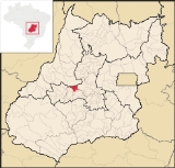
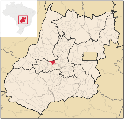
Mossâmedes
Encyclopedia
| Mossâmedes | |
|---|---|
| State | Goiás Goiás Goiás is a state of Brazil, located in the central part of the country. The name Goiás comes from the name of an indigenous community... |
| Area: | 684.4 km² |
| Population: | 4,954 (IBGE 2007) |
| Population Density; | 7.24 inhab/km² (2007) |
| Elevation: | 615m above sea level |
| Postcode (CEP): | 76150-000 |
| IBGE statistical microregion: | Anicuns Microregion Anicuns Microregion The Anicuns Microregion is a geographical division in the state of Goiás, Brazil. It is made up of 13 municipalities located near Anicuns, a small city and municipality west of Goiânia... |
| Became a city: | 1958 |
| Mayor: | Mara Alice Aparecida da Silva Borges |
| Distance to Goiânia Goiânia -Climate:The city has a tropical wet and dry climate with an average temperature of . There's a wet season, from October to April, and a dry one, from May to September. Annual rainfall is around 1,520 mm.... : |
142 km. |
| Website: | none |
| Geographical coordinates: | 16°07′15"S 50°12′32"W |
Town
A town is a human settlement larger than a village but smaller than a city. The size a settlement must be in order to be called a "town" varies considerably in different parts of the world, so that, for example, many American "small towns" seem to British people to be no more than villages, while...
and municipality
Municipality
A municipality is essentially an urban administrative division having corporate status and usually powers of self-government. It can also be used to mean the governing body of a municipality. A municipality is a general-purpose administrative subdivision, as opposed to a special-purpose district...
in western Goiás
Goiás
Goiás is a state of Brazil, located in the central part of the country. The name Goiás comes from the name of an indigenous community...
state, Brazil
Brazil
Brazil , officially the Federative Republic of Brazil , is the largest country in South America. It is the world's fifth largest country, both by geographical area and by population with over 192 million people...
.
Location
Mossâmedes is located northwest of the state capital, GoiâniaGoiânia
-Climate:The city has a tropical wet and dry climate with an average temperature of . There's a wet season, from October to April, and a dry one, from May to September. Annual rainfall is around 1,520 mm....
in the Anicuns Microregion
Anicuns Microregion
The Anicuns Microregion is a geographical division in the state of Goiás, Brazil. It is made up of 13 municipalities located near Anicuns, a small city and municipality west of Goiânia...
. It is connected by paved roads with Itaberaí
Itaberaí
Itaberaí is a small city and municipality in central Goiás state, Brazil. Itaberaí is a large producer of agricultural products including corn, rice, soybeans, tomatoes, and sugarcane.-Location:...
to the north and Anicuns
Anicuns
Anicuns is a small city and municipality in central Goiás state, Brazil.-Geographical Facts:Anicuns is located in the Anicuns Microregion, which includes 13 cities with a population of 103276 inhabitants in a total area of 5483.10 km²....
to the south. The distance to the state capital is 142 kilometers. Road connections from Goiânia are made by GO-060 / Trindade
Trindade, Goiás
Trindade is a city and municipality in Goiás state, Brazil. It is famous for the religious celebrations held there in July and is now the third most important pilgrimage site in Brazil....
/ GO-326 / Anicuns
Anicuns
Anicuns is a small city and municipality in central Goiás state, Brazil.-Geographical Facts:Anicuns is located in the Anicuns Microregion, which includes 13 cities with a population of 103276 inhabitants in a total area of 5483.10 km²....
/ GO-222 / Chopana / GO-326 / Sanclerlândia
Sanclerlândia
Sanclerlândia is a small town and municipality in western Goiás state, Brazil. The population was 7,641 in 2005 and the total area of the municipality was 496.8 km².-Location:...
/ GO-164.
Municipal boundaries are with Goiás
Goiás, Goiás
Goiás is a small city and municipality in the state of Goiás in Brazil. The population was 24,072 in a total area of 3,108 km² . It is the former capital of the state and preserves much of its colonial heritage...
, Sanclerlândia
Sanclerlândia
Sanclerlândia is a small town and municipality in western Goiás state, Brazil. The population was 7,641 in 2005 and the total area of the municipality was 496.8 km².-Location:...
, Adelândia
Adelândia
Adelândia is a small town and municipality in eastern Goiás state, Brazil.-Location:The distance to the state capital Goiânia is 129 km. while the distance to the regional center São Luís de Montes Belos is 6 km....
, Americano do Brasil
Americano do Brasil
Americano do Brasil is a small town and municipality in eastern Goiás state, Brazil.-Location:Americano do Brasil is located in the Anicuns Microregion, which is northwest of the state capital, Goiânia. It is 37 kilometers southwest of Itaberaí and 113 kilometers northwest of Goiânia. Highway...
, Anicuns
Anicuns
Anicuns is a small city and municipality in central Goiás state, Brazil.-Geographical Facts:Anicuns is located in the Anicuns Microregion, which includes 13 cities with a population of 103276 inhabitants in a total area of 5483.10 km²....
, Itaberaí
Itaberaí
Itaberaí is a small city and municipality in central Goiás state, Brazil. Itaberaí is a large producer of agricultural products including corn, rice, soybeans, tomatoes, and sugarcane.-Location:...
and Buriti de Goiás
Buriti de Goiás
Buriti de Goiás is a small town and municipality in eastern Goiás state, Brazil.-Location and Communications:*Distance to regional center : 58 km....
Demographics
The population has decreased by more than 50% since 1980, when it was 12,208. At that time most of the population was rural and did not transfer to the urban area but to other urban centers in the state. From 1991 to 2000 the geometric population growth rate was -4.83.%. In 2007 3,472 inhabitants lived in the urban area and 1,482 lived in the rural area.The economy
The main economic activities are cattle and poultry raising, small-scale farming, services, and government employment. In 2007, there were 3 industrial units and 44 retail units. There was one banking institution represented: Banco Itaú S.A. There were 83,400 head of cattle. The main agricultural products in planted area were rice, bananas, sugarcane, manioc, corn, and hearts of palm. None exceeded 1,000 hectares of planted area.Health and education
In the health sector there was 1 hospital with 20 beds and 4 walk-in health clinics. The infant mortality rate was 20.33 in every 1,000 live births, which was below the national rate of 35.0 in the same year.The school system had 6 schools and 1,170 students. There was 1 middle school and no institutions of higher learning. The adult literacy rate was 84.6%, below the national average of 86.4% in 2000. The ranking on the Municipal Human Development Index
Human Development Index
The Human Development Index is a composite statistic used to rank countries by level of "human development" and separate "very high human development", "high human development", "medium human development", and "low human development" countries...
was 0.751, which placed Mossâmedes 74 out of 242 municipalities in the state of Goiás and 1,862 out of 5,507 municipalities in the country .For the complete list see frigoletto.com.br
History
The settlement of Mossâmedes began as a village for the Indian tribes of Naundós, Acroás, and Caiapós in 1755. Its first name was São José de Mossâmedes in honor of the Captain-General Dom José de Almeida Soveral de Carvalho, Governor of the Capitania of Goiás, who was from the village of Mossâmedes in Portugal. From 1770 to 1774 the village went through a complete restructure due to its near disappearance due to the Indians' inability to adapt to life there. Damiana da Cunha, granddaughter of the chief of the Caiapós was instrumental in converting the Indians. In 1780 the village was designated a freguesia with the name of São José de Mossâmedes. In 1781, due to the continuing evasion of the Indians, another group of 800 Javaés and Carajás was brought from the Ilha do Bananal. In 1845 Mossâmedes became a district, belonging to ItaberaíItaberaí
Itaberaí is a small city and municipality in central Goiás state, Brazil. Itaberaí is a large producer of agricultural products including corn, rice, soybeans, tomatoes, and sugarcane.-Location:...
. In 1890 it was a district of Goiás
Goiás, Goiás
Goiás is a small city and municipality in the state of Goiás in Brazil. The population was 24,072 in a total area of 3,108 km² . It is the former capital of the state and preserves much of its colonial heritage...
, the territorial capital. Finally in 1938 it was raised to municipal status as Mossâmedes. Source: Sepin