

San Francisco volcanic field
Encyclopedia
Volcano
2. Bedrock3. Conduit 4. Base5. Sill6. Dike7. Layers of ash emitted by the volcano8. Flank| 9. Layers of lava emitted by the volcano10. Throat11. Parasitic cone12. Lava flow13. Vent14. Crater15...
es in northern Arizona
Arizona
Arizona ; is a state located in the southwestern region of the United States. It is also part of the western United States and the mountain west. The capital and largest city is Phoenix...
, north of Flagstaff
Flagstaff, Arizona
Flagstaff is a city located in northern Arizona, in the southwestern United States. In 2010, the city's population was 65,870. The population of the Metropolitan Statistical Area was at 134,421 in 2010. It is the county seat of Coconino County...
, USA. The field covers 1,800 square miles (4,700 km²) of the southern boundary of the Colorado Plateau
Colorado Plateau
The Colorado Plateau, also called the Colorado Plateau Province, is a physiographic region of the Intermontane Plateaus, roughly centered on the Four Corners region of the southwestern United States. The province covers an area of 337,000 km2 within western Colorado, northwestern New Mexico,...
. The field contains 600 volcanoes ranging in age from less than 6 million years old to less than 1,000 years (Miocene
Miocene
The Miocene is a geological epoch of the Neogene Period and extends from about . The Miocene was named by Sir Charles Lyell. Its name comes from the Greek words and and means "less recent" because it has 18% fewer modern sea invertebrates than the Pliocene. The Miocene follows the Oligocene...
to Holocene
Holocene
The Holocene is a geological epoch which began at the end of the Pleistocene and continues to the present. The Holocene is part of the Quaternary period. Its name comes from the Greek words and , meaning "entirely recent"...
), of which Sunset Crater
Sunset Crater
Sunset Crater is a volcanic cinder cone located north of Flagstaff in U.S. State of Arizona. The crater is within the Sunset Crater Volcano National Monument....
is the youngest. The highest peak in the field is Humphreys Peak
Humphreys Peak
Humphreys Peak is the highest natural point in the U.S. state of Arizona, with an elevation of and is located within the Kachina Peaks Wilderness in the Coconino National Forest, about north of Flagstaff, Arizona. Humphreys Peak is the highest of a group of extinct volcanic peaks known as the...
, at Flagstaff's northern perimeter: the peak is Arizona
Arizona
Arizona ; is a state located in the southwestern region of the United States. It is also part of the western United States and the mountain west. The capital and largest city is Phoenix...
's highest at 12,633 feet (3,850 m) and is a part of the San Francisco Peaks
San Francisco Peaks
The San Francisco Peaks are a volcanic mountain range located in north central Arizona, just north of Flagstaff.The highest summit in the range, Humphreys Peak, is the highest point in the state of Arizona at in elevation. The San Francisco Peaks are the remains of an eroded stratovolcano...
, an extinct stratovolcano complex.
Description
The volcanic field seems to have formed from a geological hotspotHotspot (geology)
The places known as hotspots or hot spots in geology are volcanic regions thought to be fed by underlying mantle that is anomalously hot compared with the mantle elsewhere. They may be on, near to, or far from tectonic plate boundaries. There are two hypotheses to explain them...
, a hot area in the mantle. As the North American plate
North American Plate
The North American Plate is a tectonic plate covering most of North America, Greenland, Cuba, Bahamas, and parts of Siberia, Japan and Iceland. It extends eastward to the Mid-Atlantic Ridge and westward to the Chersky Range in eastern Siberia. The plate includes both continental and oceanic crust...
moves over the spot, new volcanoes appear. Thus, the newest volcanoes are at the east side of the field. Most of the volcanoes are basalt
Basalt
Basalt is a common extrusive volcanic rock. It is usually grey to black and fine-grained due to rapid cooling of lava at the surface of a planet. It may be porphyritic containing larger crystals in a fine matrix, or vesicular, or frothy scoria. Unweathered basalt is black or grey...
cinder cone
Cinder cone
According to the , Cinder Cone is the proper name of 1 cinder cone in Canada and 7 cinder cones in the United States:In Canada: Cinder Cone In the United States:...
s, but there are also large lava dome
Lava dome
|250px|thumb|right|Image of the [[rhyolitic]] lava dome of [[Chaitén Volcano]] during its 2008–2009 eruption.In volcanology, a lava dome is a roughly circular mound-shaped protrusion resulting from the slow extrusion of viscous lava from a volcano...
s consisting of rhyolite
Rhyolite
This page is about a volcanic rock. For the ghost town see Rhyolite, Nevada, and for the satellite system, see Rhyolite/Aquacade.Rhyolite is an igneous, volcanic rock, of felsic composition . It may have any texture from glassy to aphanitic to porphyritic...
and dacite
Dacite
Dacite is an igneous, volcanic rock. It has an aphanitic to porphyritic texture and is intermediate in composition between andesite and rhyolite. The relative proportions of feldspars and quartz in dacite, and in many other volcanic rocks, are illustrated in the QAPF diagram...
.
Given that Sunset Crater
Sunset Crater
Sunset Crater is a volcanic cinder cone located north of Flagstaff in U.S. State of Arizona. The crater is within the Sunset Crater Volcano National Monument....
is such a young volcanic feature of this area and that eruptions have occurred every several thousands of years in frequency, it is likely that there will be a future eruption in the San Francisco Volcanic field. However, it is impossible to predict when and exactly where a new eruption might occur. The USGS (United States Geological Survey) does say that a future eruption would most likely be in the eastern side of the volcanic field, where the most recent volcanic activity has occurred. Such an eruption is likely to be small and pose little or no hazard due to the remoteness of the area.
Visitation and usage
Popular tourist and hiking destinations in the volcanic field include the Kendrick Mountain WildernessKendrick Mountain Wilderness
Kendrick Mountain Wilderness is a wilderness area in the U.S. State of Arizona. It lies north of the city of Flagstaff on the Coconino Plateau in Coconino County. Kendrick Mountain Wilderness was designated a protected Wilderness area by Congress in 1984. About two thirds of the wilderness is...
, 20 miles northwest of Flagstaff; and Sunset Crater
Sunset Crater
Sunset Crater is a volcanic cinder cone located north of Flagstaff in U.S. State of Arizona. The crater is within the Sunset Crater Volcano National Monument....
. Sunset Crater is particularly popular, because it is easily accessible and has interesting horizontal lava flows at the base of the crater.
Areas of the volcanic field have been used by NASA
NASA
The National Aeronautics and Space Administration is the agency of the United States government that is responsible for the nation's civilian space program and for aeronautics and aerospace research...
for testing landing craft in a simulated terrain environment.
Notable Vents
| Name | Elevation | Location | Last eruption | |
| meters | feet | Coordinates | ||
| Bill Williams Mountain | - | 9256 ft | - | 2.8 million years ago |
| Crater 160 | 1,900 | 6,232 | 35°30′N 111°36′W | - |
| Double Crater Double Crater Double Crater is an extinct Pleistocene volcano within the San Francisco volcanic field, north of Flagstaff, Arizona. It is to the southeast of Sunset Crater.... |
2426 | 7959 | 35°20′44"N 111°27′5"W | - |
| Kendrick Peak Kendrick Peak Kendrick Peak or Kendrick Mountain is one of the highest peaks in the San Francisco volcanic field north of the city of Flagstaff in the U.S... |
3,175 | 10,418 | - | 1.4 million years ago |
| O'Leary Peak O'Leary Peak O'Leary Peak is an extinct Pleistocene lava dome volcano within the San Francisco volcanic field, north of Flagstaff, Arizona. It is to the northwest of Sunset Crater. A fire tower was built at the top of the eastern peak, at an elevation of . O'Leary's western summit is at -References:-External... |
2,718 | 8,916 | 35°24′05"N 111°31′36"W | Pleistocene Pleistocene The Pleistocene is the epoch from 2,588,000 to 11,700 years BP that spans the world's recent period of repeated glaciations. The name pleistocene is derived from the Greek and .... |
| San Francisco Peaks San Francisco Peaks The San Francisco Peaks are a volcanic mountain range located in north central Arizona, just north of Flagstaff.The highest summit in the range, Humphreys Peak, is the highest point in the state of Arizona at in elevation. The San Francisco Peaks are the remains of an eroded stratovolcano... |
3,851 | 12,633 | 35°20′47"N 111°40′40"W | - |
| Mount Elden Mount Elden Mount Elden, or Elden Mountain, is located in central Coconino County northeast of Flagstaff, Arizona. It takes its name from one of the region's earliest Anglo settlers, John Elden, who, along with his family, established a homestead on the mountain’s lower slopes and grazed sheep on the open... |
3,851 | 9,300 | 35°20′47"N 111°40′40"W | - |
| Sitgreaves Mountain | - | - | - | 1.9 million years ago |
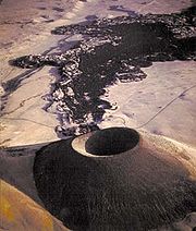
| SP Crater SP Crater S P Crater is a cinder cone volcano in the San Francisco volcanic field, north of Flagstaff, Arizona. It is surrounded by several other cinder cones which are older and more eroded. It is a striking feature on the local landscape, with a well-defined lava flow that extends for to the... (SP Mountain) |
2141 | 7021 | 35°34′56"N 111°37′55"W | 71,000 years ago |
| Strawberry Crater Strawberry Crater Strawberry Crater is a 6526 ft cinder cone volcano in the San Francisco volcanic field, 20 miles North of Flagstaff, Arizona, in between the boundaries of the Wupatki National Monument and Sunset Crater National Monument in Arizona Wilderness lands... |
35°26′38"N 111°28′40"W | - | ||
| Sunset Crater Sunset Crater Sunset Crater is a volcanic cinder cone located north of Flagstaff in U.S. State of Arizona. The crater is within the Sunset Crater Volcano National Monument.... |
2447 | 8026 | 35°21′51"N 111°30′11"W | 950 ± 40 years |
| Sugarloaf | - | - | - | 220,000 years ago |