

San Carlos Water
Encyclopedia
San Carlos Water is a bay/fjord
Fjord
Geologically, a fjord is a long, narrow inlet with steep sides or cliffs, created in a valley carved by glacial activity.-Formation:A fjord is formed when a glacier cuts a U-shaped valley by abrasion of the surrounding bedrock. Glacial melting is accompanied by rebound of Earth's crust as the ice...
on the west coast of East Falkland
East Falkland
East Falkland the largest of the Falkland Islands in the South Atlantic, has an area of and a coastline long. Most of the population of the Falklands live in East Falkland, almost all of them living in the northern half of the island...
, facing onto the Falkland Sound
Falkland Sound
The Falkland Sound is a sea strait in the Falkland Islands. Running south west - north east, it separates West and East Falkland.-Name:The sound was named by John Strong in 1690 for Viscount Falkland, the name only later being applied to the archipelago and its two largest islands...
.
Name
Despite its SpanishSpanish language
Spanish , also known as Castilian , is a Romance language in the Ibero-Romance group that evolved from several languages and dialects in central-northern Iberia around the 9th century and gradually spread with the expansion of the Kingdom of Castile into central and southern Iberia during the...
sounding name, there is a wide descrepancy with the Spanish usage, for in Spanish "Estrecho de San Carlos" refers to all of the much larger Falkland Sound
Falkland Sound
The Falkland Sound is a sea strait in the Falkland Islands. Running south west - north east, it separates West and East Falkland.-Name:The sound was named by John Strong in 1690 for Viscount Falkland, the name only later being applied to the archipelago and its two largest islands...
, which runs between the two main islands of West Falkland
West Falkland
West Falkland is the second largest of the Falkland Islands in the South Atlantic. It is a hilly island, separated from East Falkland by Falkland Sound. Its area is and its coastline is long. Including the adjacent small islands the land area is .-Population:The island has fewer than 200...
and East Falkland.
The settlements of San Carlos
San Carlos, Falkland Islands
San Carlos is a settlement in northwestern East Falkland, lying south of Port San Carlos on San Carlos Water. It is sometimes nicknamed "JB" after a former owner, Jack Bonner.-History:...
and Port San Carlos
Port San Carlos
Port San Carlos is located on the northern bank of the inlet known as Port San Carlos, off San Carlos Water on the Western coast of East Falkland, in the Falkland Islands...
on the Water, as well as San Carlos River all take their name from the ship San Carlos which visited in 1768.
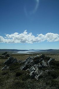
Description
San Carlos Water is a fjord-likeFjord
Geologically, a fjord is a long, narrow inlet with steep sides or cliffs, created in a valley carved by glacial activity.-Formation:A fjord is formed when a glacier cuts a U-shaped valley by abrasion of the surrounding bedrock. Glacial melting is accompanied by rebound of Earth's crust as the ice...
inlet at an angle of 45° to the Falkland Sound
Falkland Sound
The Falkland Sound is a sea strait in the Falkland Islands. Running south west - north east, it separates West and East Falkland.-Name:The sound was named by John Strong in 1690 for Viscount Falkland, the name only later being applied to the archipelago and its two largest islands...
coastline, thereby offering shelter from the weather in the Sound (which is itself sheltered from the South Atlantic by bluffs in the north and an archipelago
Archipelago
An archipelago , sometimes called an island group, is a chain or cluster of islands. The word archipelago is derived from the Greek ἄρχι- – arkhi- and πέλαγος – pélagos through the Italian arcipelago...
in the south). The inlet is 9.3 miles (15 km) in length and for about half of its length, is about 1.2 miles (2 km) wide. It is flat-bottomed with a depth of between 20 and 30 m (65.6 and 98.4 ); the 20 m isobath
Bathymetry
Bathymetry is the study of underwater depth of lake or ocean floors. In other words, bathymetry is the underwater equivalent to hypsometry. The name comes from Greek βαθύς , "deep", and μέτρον , "measure"...
lying about 660 feet (200 m) offshore. The tidal range at Port San Carlos
Port San Carlos
Port San Carlos is located on the northern bank of the inlet known as Port San Carlos, off San Carlos Water on the Western coast of East Falkland, in the Falkland Islands...
varies between 0.9 and 1.6 m (3 and 5.2 ) (for neap and spring tides respectively) with low water being between 0.3 and 0.7 m (0.984251968503937 and 2.3 ) above the chart datum
Chart datum
A chart datum is the level of water that charted depths displayed on a nautical chart are measured from. A chart datum is generally a tidal datum; that is, a datum derived from some phase of the tide...
. The San Carlos settlement lies close to the head of the inlet.
The inlet has eight official anchorage points.
The smaller and shallower Port San Carlos is an inlet to the north of San Carlos Water.
History
San Carlos Water became notorious during the Falklands WarFalklands War
The Falklands War , also called the Falklands Conflict or Falklands Crisis, was fought in 1982 between Argentina and the United Kingdom over the disputed Falkland Islands and South Georgia and the South Sandwich Islands...
as "Bomb Alley" during the Battle of San Carlos
Battle of San Carlos (1982)
The Battle of San Carlos was a major battle between aircraft and ships that lasted from 21 to 25 May 1982 during the British landings on the shores of San Carlos Water in the 1982 Falklands War . Low-flying land-based Argentine jet aircraft made repeated attacks on ships of the British Task Force...
. British troops routed the Argentine land forces, but British ships were pounded by Argentine air raids. It was of crucial strategic value in the amphibious assault, and British invasion of Argentine occupied East Falkland.
Along with Grantham Sound
Grantham Sound
Grantham Sound is a bay on East Falkland, Falkland Islands, which opens out into the Falkland Sound. At its landward end, it narrows and becomes Brenton Loch . Mount Usborne overlooks it....
, it is one of the proposed East Falkland
East Falkland
East Falkland the largest of the Falkland Islands in the South Atlantic, has an area of and a coastline long. Most of the population of the Falklands live in East Falkland, almost all of them living in the northern half of the island...
termini for the anticipated ferry to West Falkland
West Falkland
West Falkland is the second largest of the Falkland Islands in the South Atlantic. It is a hilly island, separated from East Falkland by Falkland Sound. Its area is and its coastline is long. Including the adjacent small islands the land area is .-Population:The island has fewer than 200...
.