
Samangan Province
Encyclopedia
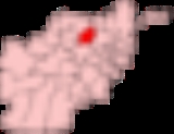
Samangan is one of the thirty-four provinces of Afghanistan
. The province covers 11218 square kilometre and has a population of approximately 313,211, as of 2006.
Its capital, Samangan, is known for its ancient ruins including, notably, the Takht e Rostam
. Archaeologists are desperate to work in this province as wars and the Taliban have destroyed many of these artifacts.
identical to the Bhaktria regi on the Dargydus river south east of Zariaspa. The ruins found here establishe the city’s founding by Eukratides, the King of Bactria. It was then known as Edrisi the size of the Khulm city. Historicity of the Samangan town is dated to the Kushan dynasty reign during the 4th and 5th centuries when it was a famous Buddhist centre. Witness to this period is seen now in the form of ruins at a place called the Takht-e-Rostam, which is located 3 km from the town on a hilltop. Arabs and Mongols came to this place when it was already famous as a Buddhist religious centre. Aibak was the name given to this place when, during the medieval period, caravans used to stop here.
and at the site of Humay Qal'a southwest of Ghazni
.
The Buddhist in Takth i Raustam here in the form of a mound, located on the hilltop, represents the earliest link to the evolution of Buddhist architecture in Afghanistan
On May 8, 2000, several men from Baghlan Province were driven up to the Robotak Pass in Samangan province, approximately 20 miles north of the city of Samangan (100 miles south of Mazar-i-Sharif) and were executed, later found by local farmers in shallow graves which the Taliban had dug for them.
. A series of earthquakes struck nearby Baghlan province on March 3, 2002, killing roughly 1,000 people.
In April 2010 at least 11 people were killed and more than 70 injured when a 5.7 magnitude quake at a depth of 10 km struck the province. It damaged some 300 houses and killed hundreds of cattle, causing landslides which blocks some of the main roads.
in the west and north. The province encompasses an area of 11218 km2 constitutes of 58.8 % of mountainous terrain, 21.4 % of semi mountainous terrain, 12.4% of flat land, 4.8% of semi-flat land and the balance 2.2 % is unclassified land. Some parts of the province are characterised by distinctive rolling hills and mountains and rich green valleys. The provincial jurisdiction is spread over seven administrative districts, with Ayabak, Samangan as its capital. This town is located on the banks of the Khulm River
, in the valley formed below the junction of Hindu Kush Mountains and the Central Asian Steppe; the valley has very fertile agricultural land. The highest mountain ranges of the province thus lie to the southwest of the province, southwest of the city of Samangan. Only 12% of the provincial area consists of flat land. The city of Samangan lies in the Khulm River
valley, with mountains to the west and east. It is located to the northwest of the city of Baghlan
and about is 190 km (118.1 mi) north-west of the capital Kabul
and the same distance south-east of Mazar-i-Sharif city.
, Pashtuns, Hazaras, Arabs and Tatars
. 72.5% people speak Dari Persian and 22.1% people speak Uzbek language
. According to NPS Tajiks constitute 65% of the population.
Since November 2007, the governor is Enayatullah Enayat
.
In October 2010, the first dish-making factory run by women began operations. The women were trained for several months and now work in two shifts. During the last few years, thousands of other women have worked on a variety of different projects such as tailoring and carpet knitting.
Electricity supply is very minimal, limited to only about 5% of the population with 80% supplied from government sources. The transport sector is still underdeveloped. Only 28% of roads are good for use by motorized traffic throughout the year with this percentage rising to 41% in some seasons. However roads are non-existent in 28% of the province.
Education is still in a nascent state of development with only 19% being literate, as of 2005, with literacy among men limited to 28% and literacy among women limited to a mere 10%; literacy among the Kuchis population is the least at about 3% of men only. There are 59 primary and secondary schools in the province with enrolment of 59,915 students. However, travelling distance to the schools varies, with primary schools being most accessible while High Schools involve about 10 km of travel.
As of 2005, basic health services maintained by the Ministry of Health were fairly developed with 6 health centres and 3 hospitals with a total of 60 beds. The health centres were well staffed with 21 doctors and 33 nurses.
Food security is a major issue since nearly 12% of the population receive less than the minimum daily caloric intake to sustain good health. Food consumption is poor in both rural and urban areas and as a result food aid has become essential.
From the security angle, the United Nations Department of Safety and Security (UNDSS) has reported security situation in the province calm and stable.
Mineral resource
Marble
export sustains Afghan economy. The marble is extracted and processed in 21 factories in the country, including the famous brown marble from Samangan province. This adds to the economy of the province.
production. As of 2005, 10 Agricultural cooperatives were functioning in the province with 665 enrolled members controlling an area of 5532 ha which brought prosperity to its members. The staple food crops grown in the province are wheat, barley and potato and flax. The horticultural or garden crops grown are grapes, pomegranates and other fruit and nut trees. Cash crops grown in a few villages were sesame, cotton and tobacco; and they are mostly in Dara-i-Soofi-Payin and Aybek districts; cotton was major crop in Hazrat-i-Sultan district while tobacco was produced on a large scale in the Roi-Do-Ab district. Use of fertilizers is also common among 60 % of the on both field and garden crops Industries are almost non existent in the province, except for minor leather industry producing the karakul skin
and a few small scale handicrafts producing rugs, shawls, jewellery and carpets.
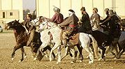 Horse breeding also sustains the economy of the province as it caters particularly for the popular sport of buzkashi
in Afghanistan. Buzkashi is a traditional Central Asian team sport played on horseback in Afghanistan, Uzbekistan
, Tajikistan
, Kyrgyzstan
, northern Pakistan
and Kazakhstan
.
Irrigation
The agricultural economy of the province is further enhanced with irrigation facility provided to 21,242 ha. The irrigated areas deciphered from the land-cover maps, under a collaborative project of FAO, the United Nations Development Programme
and the Afghan Geodesy and Cartography Office, abul are in Aybak, Samangan - 5 426ha, Dara-I-Suf, Samangan - 4 149ha, Hazrati Sult, Samangan -6 884 ha, Khuram Wa Sa, Samangan - 1 733 ha and Ruyi Du Ab, Samangan -3,049 ha.
course.
Takht-i Rustam
Takht-i Rustam (Haibak), literal meaning the throne of Rustam, named after Rustam, a king in Persian mythology
, is a hilltop settlement. It is dated to the 4th and 5th centuries of the Kushano-Sassanian period, which is corroborated by archaeological, architectural and numismatic evidence. It is located 3 km to the southwest of Samangan town. It is the location of a stupa-monastery complex which is fully carved into the mountain rock. The monastery of major Buddhist tradition of Therravada Buddhism, has five chambers, two are sanctuaries and one is a domed ceiling with an intricate lotus leaf beautification. In the adjacent hill is the stupa, which has a harmika, with several caves at its base. Above one of the caves, there is square building in which there are two conference halls; one is 22 metres square and the other is circular. In one of these caves, Archaeological excavations have revealed a cache of Ghaznavid coins. The Buddhist temples near the Takht are 10 numbers known locally as Kie Tehe.
Hazar Sum
Hazar Sum is another ancient Buddhist centre in north central Afghanistan where several caves have been found and in one of these caves a Buddhist stupa
has been carved.
Provinces of Afghanistan
The provinces of Afghanistan are the primary administrative divisions of Afghanistan. As of 2004, there are thirty-four provinces in the country. Each province is further divided into smaller districts....
. The province covers 11218 square kilometre and has a population of approximately 313,211, as of 2006.
Its capital, Samangan, is known for its ancient ruins including, notably, the Takht e Rostam
Rostam
Rostam is the national hero of Greater Iran from Zabulistan in Persian mythology and son of Zal and Rudaba. In some ways, the position of Rostam in the historical tradition is parallel to that of Surena, the hero of the Carrhae. His figure was endowed with many features of the historical...
. Archaeologists are desperate to work in this province as wars and the Taliban have destroyed many of these artifacts.
History
The earliest known history of the province is linked to the identification of the Samangan by Aoros Ptolemy as the place of the Varni or Uarni and the fortified city of Samangan on the banks of the Khulm RiverKhulm River
The Khulm River is a river of northern-central Afghanistan. In its upper course, it passes through Khulm and Haybak, today in Balkh Province. The Khulm is a tributary to the Oxus basin. Its source is located to the north of the city of Khulm...
identical to the Bhaktria regi on the Dargydus river south east of Zariaspa. The ruins found here establishe the city’s founding by Eukratides, the King of Bactria. It was then known as Edrisi the size of the Khulm city. Historicity of the Samangan town is dated to the Kushan dynasty reign during the 4th and 5th centuries when it was a famous Buddhist centre. Witness to this period is seen now in the form of ruins at a place called the Takht-e-Rostam, which is located 3 km from the town on a hilltop. Arabs and Mongols came to this place when it was already famous as a Buddhist religious centre. Aibak was the name given to this place when, during the medieval period, caravans used to stop here.
Buddhist period
Afghanistan has various archaeological sites where caves were hewn out of rocks and inhabited by Buddhists. "One of the most spectacular sites is that of Takth i Raustam, near Samangan (Haybak), north of Hindu Kush passes. It includes a complex of stupa with monastery, hewn out of the rock. Other caves have been found near JalalabadJalalabad
Jalalabad , formerly called Adinapour, as documented by the 7th century Hsüan-tsang, is a city in eastern Afghanistan. Located at the junction of the Kabul River and Kunar River near the Laghman valley, Jalalabad is the capital of Nangarhar province. It is linked by approximately of highway with...
and at the site of Humay Qal'a southwest of Ghazni
Ghazni Province
Ghazni is one of the thirty-four provinces of Afghanistan. Babur records in his Babur-Nama that Ghazni is also known as Zabulistan It is in the east of the country. Its capital is Ghazni City...
.
The Buddhist in Takth i Raustam here in the form of a mound, located on the hilltop, represents the earliest link to the evolution of Buddhist architecture in Afghanistan
Taliban
The town of Darra Souf in Samangan Province was occupied by Ustad Mohammad Mohaqiq and the Taliban in late 1999. The Taliban gained control of the area from January 2000 to March 2000 including nearby Sar-e-Pul Province and Baghlan Province where they were reported to have massacred many civilians.On May 8, 2000, several men from Baghlan Province were driven up to the Robotak Pass in Samangan province, approximately 20 miles north of the city of Samangan (100 miles south of Mazar-i-Sharif) and were executed, later found by local farmers in shallow graves which the Taliban had dug for them.
Earthquakes
Samangan Province has a long history of earthquakes which has led to the loss of thousands of people and their homes. In 1998, two earthquakes struck measuring 5.9 and 6.6 on the Richter scale, claiming some 6,000 lives along the border with TajikistanTajikistan
Tajikistan , officially the Republic of Tajikistan , is a mountainous landlocked country in Central Asia. Afghanistan borders it to the south, Uzbekistan to the west, Kyrgyzstan to the north, and China to the east....
. A series of earthquakes struck nearby Baghlan province on March 3, 2002, killing roughly 1,000 people.
In April 2010 at least 11 people were killed and more than 70 injured when a 5.7 magnitude quake at a depth of 10 km struck the province. It damaged some 300 houses and killed hundreds of cattle, causing landslides which blocks some of the main roads.
Geography
Samangan Province is one of the thirty-four provinces of Afghanistan located in northern central Afghanistan, delimited by the Baghlan Province in the east, Bamyan Province in the south, Sar-i-Pul Province in the south-west and Balkh ProvinceBalkh Province
Balkh is one of the thirty-four provinces of Afghanistan. It is in the north of the country and its name derives from the ancient city of Balkh, near the modern town...
in the west and north. The province encompasses an area of 11218 km2 constitutes of 58.8 % of mountainous terrain, 21.4 % of semi mountainous terrain, 12.4% of flat land, 4.8% of semi-flat land and the balance 2.2 % is unclassified land. Some parts of the province are characterised by distinctive rolling hills and mountains and rich green valleys. The provincial jurisdiction is spread over seven administrative districts, with Ayabak, Samangan as its capital. This town is located on the banks of the Khulm River
Khulm River
The Khulm River is a river of northern-central Afghanistan. In its upper course, it passes through Khulm and Haybak, today in Balkh Province. The Khulm is a tributary to the Oxus basin. Its source is located to the north of the city of Khulm...
, in the valley formed below the junction of Hindu Kush Mountains and the Central Asian Steppe; the valley has very fertile agricultural land. The highest mountain ranges of the province thus lie to the southwest of the province, southwest of the city of Samangan. Only 12% of the provincial area consists of flat land. The city of Samangan lies in the Khulm River
Khulm River
The Khulm River is a river of northern-central Afghanistan. In its upper course, it passes through Khulm and Haybak, today in Balkh Province. The Khulm is a tributary to the Oxus basin. Its source is located to the north of the city of Khulm...
valley, with mountains to the west and east. It is located to the northwest of the city of Baghlan
Baghlan
Baghlan is a city in northern Afghanistan, in the eponymous province, Baghlan Province. It is located three miles east of the Kunduz River, 35 miles south of Khanabad, and about 1,700 metres above sea level in the northern Hindu Kush...
and about is 190 km (118.1 mi) north-west of the capital Kabul
Kabul
Kabul , spelt Caubul in some classic literatures, is the capital and largest city of Afghanistan. It is also the capital of the Kabul Province, located in the eastern section of Afghanistan...
and the same distance south-east of Mazar-i-Sharif city.
Districts
| District | Capital | Population | Area | Notes |
|---|---|---|---|---|
| Aybak Aybak District Aybak District is a district in Samangan Province, Afghanistan. It contains the town of Aybak which serves as the provincial capital of Samangan.... |
Aybak, Samangan | 85,427 | 909.91676 | |
| Darah Sof Balla | Darah Sof Balla | 52,473 | Created in 2005 within Darah Sof District | |
| Darah Sof Payan | Darah Sof Payan | 55,858 |
4539.27567 | Created in 2005 within Darah Sof District |
| Feroz Nakhchir Feroz Nakhchir District Feroz Nakhchir District is a district of Samangan Province, Afghanistan. It formerly belonged to Balkh Province and shifted in 2005.... |
Feroz Nakhchir | 11,701 | Created within Khulmi District and shifted from Balkh Province Balkh Province Balkh is one of the thirty-four provinces of Afghanistan. It is in the north of the country and its name derives from the ancient city of Balkh, near the modern town... in 2005 |
|
| Hazrati Sultan Hazrati Sultan District Hazrati Sultan District is a district in Samangan Province, Afghanistan. It is also locally known as Azrat Sultan.... |
Hazrati Sultan | 36,690 | 1223.92574 | |
| Khuram Wa Sarbagh Khuram Wa Sarbagh District Khuram Wa Sarbagh District is a district in Samangan Province, Afghanistan.... |
Khuram Wa Sarbagh | 30,704 | ||
| Ruyi Du Ab Ruyi Du Ab District Ruyi Du Ab District is a district in Samangan Province, northern Afghanistan.... |
Ruyi Ruyi Ruyi is a curved decorative object that is a ceremonial sceptre in Chinese Buddhism or a talisman symbolizing power and good fortune in Chinese folklore. A traditional ruyi has a long S-shaped handle and a head fashioned like a fist, cloud, or lingzhi mushroom. Ruyi are constructed from diverse... |
40,358 |
Towns and villages
- Abdan-e ShebaqliAbdan-e ShebaqliAbdan-e Shebaqli is a small village in Samangan Province, in northern Afghanistan. It is located east of Kholm by road.-External links:*...
- Ab Khvorak-e BalaAb Khvorak-e BalaAb Khvorak-e Bala is a small village in Samangan Province, in northern Afghanistan. It is located in the very south of Samangan Province, about 200 miles northwest of Kabul.Several fields are located in the vicinity to provide the locals with food supply in this isolated village.-External links:*...
- Ab Khvorak-e Pa'inAb Khvorak-e Pa'inAb Khvorak-e Pa'in is a small village in Samangan Province, in northern Afghanistan. It is located in the very south of Samangan Province, about 200 miles northwest of Kabul.Several fields are located in the vicinity to provide the locals with food supply in this isolated village.-External links:*...
- Aq GonbazAq GonbazAq Gonbaz is village in Samangan Province, in northern Afghanistan. It is located in the northern part of Samangan Province and lies in a dry, wide valley. Aq Gonbaz is accessed via a dirt track east of the A76 highway, to the northeast of Hazrat e Soltan....
- AsiabadAsiabadAsiabad is a village in Samangan Province, in northern Afghanistan. It lies along the A76 highway, to the immediate south of Hazrat e Soltan.-External links:*...
- Baba QanbarBaba QanbarBaba Qanbar is a village in Samangan Province, in northern Afghanistan. It is located in an isolated part of Samangan Province in a valley framed by rugged mountains all around it. It is located approximately 50 kilometres southeast of Samangan .Fields are located around the village in an otherwise...
- BalahesarBalahesarBalahesar is a village in Samangan Province, in northern Afghanistan. It is located approximately 80 kilometres southwest of Samangan .-External links:*...
- Band-e SareqBand-e SareqBand-e Sareq is a village in Samangan Province, in northern Afghanistan. It is located in the western part of Samangan Province, approximately 30 kilometres northeast of Chamchal.-External links:*...
- Besh QolBesh QolBesh Qol is a village in Samangan Province, in northern Afghanistan. It is located approximately 50 kilometres west of Pol-e-Khomri.-External links:*...
- Chahar Cheshmeh
- Chahar Deh
- Chahar Owlia'
- Changiz
- Dagah
- Dahaneh-ye Shams od Din
- DalkhakiDalkhakiDalkhaki is a village in Samangan Province, in northern Afghanistan.It lies 10 miles northwest of Aibak at an elevation of 3015 feet. The Tashkurgan River flows nearby, where it cuts an east-west ridge. It had a reported 120 families in the 1979 census....
- Dehi
- Deh Mirdad
- Deh Now
- Do AbDo AbDo Ab is a village in Bamiyan Province in central Afghanistan. It is located in a pass in a mountainous region North East Of Barmiyan town on the Ghandak highway 10Km from the border with Baghlan Province. It has a bazaar,a coal weigh station built in 2007 and a police check point...
- Ghazni Gak
- Gozar
- HasaniHašaniHašani is a village in the municipality of Bosanska Krupa, Bosnia and Herzegovina....
- Hazar Som
- Hazrat-e Soltan
- Heyratan
- Hezarmani
- Jan Bulaq
- Jeyretan
- Juy-ye Jadid
- Kaldar
- Katah Qeshlaq
- KholmKholm, AfghanistanKholm or Khulm is a town, until recently, in Samangan province, and now in Balkh province of northern Afghanistan 60 km east of Mazar-i-Sharif one-third of the way to Konduz. Kholm is an ancient town located on the fertile, inland delta fan of the Khulm River . As such, it is an...
- Khvajeh Hayat
- Khvajeh Zahed
- Kolowr va Dah Sil
- Kowkeh Bulaq
- Larghan
- Maschetak
- Na'ebabad
- Orlamesh
- Pir Nakhchir
- Qalacheh
- Qal`eh-ye NowQal`eh-ye Now-External links:*...
- Qal`eh-ye Sarkari
- Qareh Aghach
- Qashaqeh
- Qaynar-e Bala
- Qaynar-e Pa'in
- Ru'i
- Ru'i
- Sad Mardeh
- SamanganSamanganSamangan is a provincial town, medieval caravan stop, and the headquarters of the Samangan Province in the district of the same name in the northern part of Afghanistan...
- Sar-e Asia
- Sar-e Bum
- SayyadSayyad-External links:*...
- Seyghanchi
- Shabashak
- ShahidanShahidanShahidan / شهیدان is located in Bamiyan., about northwest of Kabul and west of Bamiyan city, the provincial capital of Bamiyan Province. A large place between two famous mountain ranges Koh-i-Baba and Hindu Kush.Shahidan had a population of 25,500...
- Sharik Yar
- Sorkh Abi
- Taghan Gozar
- Taqchi
- Towz Bulaq
- Werdaqamal
- Yangi Aregh
Demographics
The total population of the province in its seven districts as of 2006 is 313,211; it is predominately rural with only 7% living in urban centres. The male population is 51.2% while the female population constitutes 48.8%. The major ethnic group in the province are Tajiks followed by UzbeksUzbeks
The Uzbeks are a Turkic ethnic group in Central Asia. They comprise the majority population of Uzbekistan, and large populations can also be found in Afghanistan, Tajikstan, Kyrgyzstan, Turkmenistan, Kazakhstan, Russia, Pakistan, Mongolia and the Xinjiang Uyghur Autonomous Region of China...
, Pashtuns, Hazaras, Arabs and Tatars
Tatars
Tatars are a Turkic speaking ethnic group , numbering roughly 7 million.The majority of Tatars live in the Russian Federation, with a population of around 5.5 million, about 2 million of which in the republic of Tatarstan.Significant minority populations are found in Uzbekistan, Kazakhstan,...
. 72.5% people speak Dari Persian and 22.1% people speak Uzbek language
Uzbek language
Uzbek is a Turkic language and the official language of Uzbekistan. It has about 25.5 million native speakers, and it is spoken by the Uzbeks in Uzbekistan and elsewhere in Central Asia...
. According to NPS Tajiks constitute 65% of the population.
Since November 2007, the governor is Enayatullah Enayat
Enayatullah Enayat
Enayatullah Enayat was Governor of Faryab Province in Afghanistan from 2003 until 2005, when he was appointed as Governor of Badghis Province. Enayat is currently the governor of Samangan Province.-References:...
.
Administrative setup
The Provincial Development Committee (PDC), under the directive of the Ministry of Economy of Afghanistan, was formed for the Samangan Province, in January 2006. It has the responsibility to implement the Provincial Development Plan, through the government departments. Stakeholder groups in the province are also involved in this process. Further, at the community and village level there are 424 Community Development Councils (CDC) in the province to implement the development plans at the district and village level. The PDC and CDC have the basic tasks of creating infrastructure facilities of water supply and sanitation, energy, transport and communications to further economic growth with involvement of the private sector.Economy
Owing to its relative isolation, Samangan Province is underdeveloped with no energy infrastructure and has a high rate of illiteracy, although some students have access to education in neighbouring Mazari Sharif. Economic condition of the people is very hard with nearly 12% households finding it difficult to meet the food requirements to sustain. This has resulted in allocations of food aid to the province.In October 2010, the first dish-making factory run by women began operations. The women were trained for several months and now work in two shifts. During the last few years, thousands of other women have worked on a variety of different projects such as tailoring and carpet knitting.
Status of infrastructure
As of 2005, safe drinking water access is available to 7% of households ( falls to a low of 4% in rural areas). However, some drinking water facility is available in some form to about 71% of households. Still many households have to travel for long hours to the nearest source of water.Electricity supply is very minimal, limited to only about 5% of the population with 80% supplied from government sources. The transport sector is still underdeveloped. Only 28% of roads are good for use by motorized traffic throughout the year with this percentage rising to 41% in some seasons. However roads are non-existent in 28% of the province.
Education is still in a nascent state of development with only 19% being literate, as of 2005, with literacy among men limited to 28% and literacy among women limited to a mere 10%; literacy among the Kuchis population is the least at about 3% of men only. There are 59 primary and secondary schools in the province with enrolment of 59,915 students. However, travelling distance to the schools varies, with primary schools being most accessible while High Schools involve about 10 km of travel.
As of 2005, basic health services maintained by the Ministry of Health were fairly developed with 6 health centres and 3 hospitals with a total of 60 beds. The health centres were well staffed with 21 doctors and 33 nurses.
Food security is a major issue since nearly 12% of the population receive less than the minimum daily caloric intake to sustain good health. Food consumption is poor in both rural and urban areas and as a result food aid has become essential.
From the security angle, the United Nations Department of Safety and Security (UNDSS) has reported security situation in the province calm and stable.
Mineral resource
Marble
Marble
Marble is a metamorphic rock composed of recrystallized carbonate minerals, most commonly calcite or dolomite.Geologists use the term "marble" to refer to metamorphosed limestone; however stonemasons use the term more broadly to encompass unmetamorphosed limestone.Marble is commonly used for...
export sustains Afghan economy. The marble is extracted and processed in 21 factories in the country, including the famous brown marble from Samangan province. This adds to the economy of the province.
Agriculture
The economy revolves around agriculture, with farmers in Samangan province cultivating grains, fruits, and nuts on the region’s fertile river plains. The province of Samangan is second only to the northwestern Afghan province of Badghis in terms of pistachioPistachio
The pistachio, Pistacia vera in the Anacardiaceae family, is a small tree originally from Persia , which now can also be found in regions of Syria, Lebanon, Turkey, Greece, Kyrgyzstan, Turkmenistan, India, Pakistan, Egypt, Sicily and possibly Afghanistan , as well as in the United States,...
production. As of 2005, 10 Agricultural cooperatives were functioning in the province with 665 enrolled members controlling an area of 5532 ha which brought prosperity to its members. The staple food crops grown in the province are wheat, barley and potato and flax. The horticultural or garden crops grown are grapes, pomegranates and other fruit and nut trees. Cash crops grown in a few villages were sesame, cotton and tobacco; and they are mostly in Dara-i-Soofi-Payin and Aybek districts; cotton was major crop in Hazrat-i-Sultan district while tobacco was produced on a large scale in the Roi-Do-Ab district. Use of fertilizers is also common among 60 % of the on both field and garden crops Industries are almost non existent in the province, except for minor leather industry producing the karakul skin
Karakul
See also: Karakul Karakul or Qaraqul is a breed of domestic sheep which originated in Central Asia...
and a few small scale handicrafts producing rugs, shawls, jewellery and carpets.
Buzkashi
Buzkashi or Kok-boru or Oglak Tartis or Ulak Tartysh is a traditional Central Asian...
in Afghanistan. Buzkashi is a traditional Central Asian team sport played on horseback in Afghanistan, Uzbekistan
Uzbekistan
Uzbekistan , officially the Republic of Uzbekistan is a doubly landlocked country in Central Asia and one of the six independent Turkic states. It shares borders with Kazakhstan to the west and to the north, Kyrgyzstan and Tajikistan to the east, and Afghanistan and Turkmenistan to the south....
, Tajikistan
Tajikistan
Tajikistan , officially the Republic of Tajikistan , is a mountainous landlocked country in Central Asia. Afghanistan borders it to the south, Uzbekistan to the west, Kyrgyzstan to the north, and China to the east....
, Kyrgyzstan
Kyrgyzstan
Kyrgyzstan , officially the Kyrgyz Republic is one of the world's six independent Turkic states . Located in Central Asia, landlocked and mountainous, Kyrgyzstan is bordered by Kazakhstan to the north, Uzbekistan to the west, Tajikistan to the southwest and China to the east...
, northern Pakistan
Pakistan
Pakistan , officially the Islamic Republic of Pakistan is a sovereign state in South Asia. It has a coastline along the Arabian Sea and the Gulf of Oman in the south and is bordered by Afghanistan and Iran in the west, India in the east and China in the far northeast. In the north, Tajikistan...
and Kazakhstan
Kazakhstan
Kazakhstan , officially the Republic of Kazakhstan, is a transcontinental country in Central Asia and Eastern Europe. Ranked as the ninth largest country in the world, it is also the world's largest landlocked country; its territory of is greater than Western Europe...
.
Irrigation
The agricultural economy of the province is further enhanced with irrigation facility provided to 21,242 ha. The irrigated areas deciphered from the land-cover maps, under a collaborative project of FAO, the United Nations Development Programme
United Nations Development Programme
The United Nations Development Programme is the United Nations' global development network. It advocates for change and connects countries to knowledge, experience and resources to help people build a better life. UNDP operates in 177 countries, working with nations on their own solutions to...
and the Afghan Geodesy and Cartography Office, abul are in Aybak, Samangan - 5 426ha, Dara-I-Suf, Samangan - 4 149ha, Hazrati Sult, Samangan -6 884 ha, Khuram Wa Sa, Samangan - 1 733 ha and Ruyi Du Ab, Samangan -3,049 ha.
Education
Educational facilities in the province is at a low level with literacy rate recorded at only 19% for the province as a whole, with 28 % literacy rate among men and a low of 10 % among women. The Kuchi people are the least literate, recording a literacy rate of only 3%, that too among men only. The province has 159 primary and secondary schools with attendance of 59,915 students; 83% of schools are boys’ schools with 68% students. While the village schools are within easy reach, the high schools are generally about 10 km away from the villages.Health
Health services provided by the Ministry of Health are fairly basic with 6 health centres and 3 hospitals with 60 beds. They are reasonably well staffed with 21 doctors and 33 nurses. To cater to the pharmaceutical needs of the patients, there are 24 pharmacies, two are run by the government and the rest are privately owned. In 2006, two dozen women completed a midwiferyMidwifery
Midwifery is a health care profession in which providers offer care to childbearing women during pregnancy, labour and birth, and during the postpartum period. They also help care for the newborn and assist the mother with breastfeeding....
course.
Security
The province has a fairly good security situation with the United Nations Department of Safety and Security (UNDSS) reporting a calm and stable condition. However, on 15 February 2011 an Finnish ISAF peacekeeper was killed in a roadside bombing near Aybak.Cultural heritage
The historical cultural heritage in the province which is mainly at the Aybak, Samangan city, the provincial headquarters of Samangan are the Takt-e Rostam and the adjacent Buddhist caves and stupas on a top of hill.Takht-i Rustam
Takht-i Rustam (Haibak), literal meaning the throne of Rustam, named after Rustam, a king in Persian mythology
Persian mythology
Persian mythology are traditional tales and stories of ancient origin, some involving extraordinary or supernatural beings. Drawn from the legendary past of the Iranian cultural continent which especially consists of the state of Iran, Afghanistan, Tajikistan and Central Asia, they reflect the...
, is a hilltop settlement. It is dated to the 4th and 5th centuries of the Kushano-Sassanian period, which is corroborated by archaeological, architectural and numismatic evidence. It is located 3 km to the southwest of Samangan town. It is the location of a stupa-monastery complex which is fully carved into the mountain rock. The monastery of major Buddhist tradition of Therravada Buddhism, has five chambers, two are sanctuaries and one is a domed ceiling with an intricate lotus leaf beautification. In the adjacent hill is the stupa, which has a harmika, with several caves at its base. Above one of the caves, there is square building in which there are two conference halls; one is 22 metres square and the other is circular. In one of these caves, Archaeological excavations have revealed a cache of Ghaznavid coins. The Buddhist temples near the Takht are 10 numbers known locally as Kie Tehe.
Hazar Sum
Hazar Sum is another ancient Buddhist centre in north central Afghanistan where several caves have been found and in one of these caves a Buddhist stupa
Stupa
A stupa is a mound-like structure containing Buddhist relics, typically the remains of Buddha, used by Buddhists as a place of worship....
has been carved.
External links
- Dupree, Nancy Hatch (1977): An Historical Guide to Afghanistan. 1st Edition: 1970. 2nd Edition. Revised and Enlarged. Afghan Tourist Organization. http://www.zharov.com/dupree/index.html