
Salinity control
Encyclopedia
The aim of soil salinity control is to prevent soil degradation by salinization and reclaim
Land reclamation
Land reclamation, usually known as reclamation, is the process to create new land from sea or riverbeds. The land reclaimed is known as reclamation ground or landfill.- Habitation :...
already salty (saline) soils. Soil reclamation is also called soil improvement, rehabilitation, remediation, recuperation, or amelioration.
The primary man-made cause of salinization is irrigation
Irrigation
Irrigation may be defined as the science of artificial application of water to the land or soil. It is used to assist in the growing of agricultural crops, maintenance of landscapes, and revegetation of disturbed soils in dry areas and during periods of inadequate rainfall...
. River water
River
A river is a natural watercourse, usually freshwater, flowing towards an ocean, a lake, a sea, or another river. In a few cases, a river simply flows into the ground or dries up completely before reaching another body of water. Small rivers may also be called by several other names, including...
or groundwater
Groundwater
Groundwater is water located beneath the ground surface in soil pore spaces and in the fractures of rock formations. A unit of rock or an unconsolidated deposit is called an aquifer when it can yield a usable quantity of water. The depth at which soil pore spaces or fractures and voids in rock...
used in irrigation contains salts, which remain behind in the soil after the water has evaporated
Evaporation
Evaporation is a type of vaporization of a liquid that occurs only on the surface of a liquid. The other type of vaporization is boiling, which, instead, occurs on the entire mass of the liquid....
.
The primary method of controlling soil salinity is to permit 10-20% of the irrigation water to leach the soil, be drained and discharged through an appropriate drainage system
Drainage system (Agriculture)
An agricultural drainage system is a system by which the water level on or in the soil is controlled to enhance agricultural crop production.-Classification:Figure 1 classifies the various types of drainage systems...
. The salt concentration of the drainage water
Watertable control
Watertable control is the practice of controlling the water table in agricultural land by subsurface drainage with proper criteria to improve the crop production.- Description and definitions :...
is normally 5 to 10 times higher than that of the irrigation water, thus salt export matches salt import and it will not accumulate.
The soil salinity problem
Salty (saline) soils are soilSoil
Soil is a natural body consisting of layers of mineral constituents of variable thicknesses, which differ from the parent materials in their morphological, physical, chemical, and mineralogical characteristics...
s that have a high salt
Salt
In chemistry, salts are ionic compounds that result from the neutralization reaction of an acid and a base. They are composed of cations and anions so that the product is electrically neutral...
content. The predominant salt is normally sodium chloride
Sodium chloride
Sodium chloride, also known as salt, common salt, table salt or halite, is an inorganic compound with the formula NaCl. Sodium chloride is the salt most responsible for the salinity of the ocean and of the extracellular fluid of many multicellular organisms...
(NaCl, "table salt"). Saline soils are therefore also sodic soils but there may be sodic soils that are not saline, but alkaline.
Salty soils are a common feature and an environmental problem
Environmental impact of irrigation
Environmental impacts of irrigation are the changes in quantity and quality of soil and water as a result of irrigation and the ensuing effects on natural and social conditions at the tail-end and downstream of the irrigation scheme....
in irrigated lands in arid
Arid
A region is said to be arid when it is characterized by a severe lack of available water, to the extent of hindering or even preventing the growth and development of plant and animal life...
and semi-arid
Semi-arid
A semi-arid climate or steppe climate describes climatic regions that receive precipitation below potential evapotranspiration, but not extremely...
regions. They have poor or little crop production.
The problems are often associated with high water table
Water table
The water table is the level at which the submarine pressure is far from atmospheric pressure. It may be conveniently visualized as the 'surface' of the subsurface materials that are saturated with groundwater in a given vicinity. However, saturated conditions may extend above the water table as...
s, caused by a lack of natural subsurface drainage to the underground. Poor subsurface drainage may be caused by insufficient transport capacity of the aquifer
Aquifer
An aquifer is a wet underground layer of water-bearing permeable rock or unconsolidated materials from which groundwater can be usefully extracted using a water well. The study of water flow in aquifers and the characterization of aquifers is called hydrogeology...
or because water cannot exit the aquifer for instance, if it is situated in a topographical depression.
Worldwide, the major factor in the development of saline soils is a lack of precipitation. Most naturally saline soils are found in (semi)arid regions
Arid
A region is said to be arid when it is characterized by a severe lack of available water, to the extent of hindering or even preventing the growth and development of plant and animal life...
and climates of the globe.
Primary cause
The primary cause of man-made salinization is the salt brought in with irrigationIrrigation
Irrigation may be defined as the science of artificial application of water to the land or soil. It is used to assist in the growing of agricultural crops, maintenance of landscapes, and revegetation of disturbed soils in dry areas and during periods of inadequate rainfall...
water. All irrigation water derived from rivers or groundwater, however 'sweet', contains salts that remain behind in the soil after the water has evaporated
Evaporation
Evaporation is a type of vaporization of a liquid that occurs only on the surface of a liquid. The other type of vaporization is boiling, which, instead, occurs on the entire mass of the liquid....
, which may create the environmental issue
Environmental impact of irrigation
Environmental impacts of irrigation are the changes in quantity and quality of soil and water as a result of irrigation and the ensuing effects on natural and social conditions at the tail-end and downstream of the irrigation scheme....
.
For example, assuming irrigation water with a low salt concentration of 0.3 g/l (equal to 0.3 kg/m³ corresponding to an electric conductivity of about 0.5 dS/m) and a modest annual supply of irrigation water of 10,000 m³/ha (almost 3 mm/day) brings 3,000 kg salt/ha each year. In the absence of sufficient natural drainage (as in waterlogged soils) and without a proper leaching and drainage
Drainage
Drainage is the natural or artificial removal of surface and sub-surface water from an area. Many agricultural soils need drainage to improve production or to manage water supplies.-Early history:...
program to remove salts, this would lead to a high soil salinity and reduced crop yield
Crop yield
In agriculture, crop yield is not only a measure of the yield of cereal per unit area of land under cultivation, yield is also the seed generation of the plant itself...
s in the long run.
Much of the water used in irrigation has a higher salt content than in this example, which is compounded by that fact that many irrigation projects use a far greater annual supply of water. Sugar cane, for example, needs about 20000 m3/ha of water per year. As a result, irrigated areas often receive more than 3,000 kg/ha of salt per year and some receive as much as 10,000 kg/ha/year.
Secondary cause
The secondary cause of salinization is waterloggingWaterlogging (agriculture)
Waterlogging refers to the saturation of soil with water. Soil may be regarded as waterlogged when the water table of the groundwater is too high to conveniently permit an anticipated activity, like agriculture....
in irrigated land.
Irrigation causes changes to the natural water balance
Hydrology (agriculture)
Agricultural hydrology is the study of water balance components intervening in agricultural water management, notably in irrigation and drainage.-Water balance components:...
of irrigated lands. Large quantities of water in irrigation projects are not consumed by plants and must go somewhere. In irrigation projects it is impossible to achieve 100% irrigation efficiency where all the irrigation water is consumed by the plants. The maximum attainable irrigation efficiency is about 70% but usually it is less than 60%. This means that minimum 30%, but usually more than 40% of the irrigation water is not evaporated and it must go somewhere.
Most of the water lost this way is stored underground which can change the original hydrology of local aquifers
Aquifer
An aquifer is a wet underground layer of water-bearing permeable rock or unconsolidated materials from which groundwater can be usefully extracted using a water well. The study of water flow in aquifers and the characterization of aquifers is called hydrogeology...
considerably. Many aquifers cannot absorb and transport these quantities of water and, the water table
Water table
The water table is the level at which the submarine pressure is far from atmospheric pressure. It may be conveniently visualized as the 'surface' of the subsurface materials that are saturated with groundwater in a given vicinity. However, saturated conditions may extend above the water table as...
rises leading to water logging.
Waterlogging causes three problems:
- the shallow water table and lack of oxygenationOxygenation (environmental)Environmental oxygenation can be important to the sustainability of a particular ecosystem. Insufficient oxygen may occur in bodies of water such as ponds and rivers, tending to suppress the presence of aerobic organisms such as fish...
of the root zone reduces the yield of most crops - it leads to an accumulation of salts brought in with the irrigation water as their removal through the aquifer is blocked
- with the upward seepage of groundwaterGroundwaterGroundwater is water located beneath the ground surface in soil pore spaces and in the fractures of rock formations. A unit of rock or an unconsolidated deposit is called an aquifer when it can yield a usable quantity of water. The depth at which soil pore spaces or fractures and voids in rock...
more salts are brought into the soil and the salination is aggravated
Aquifer conditions in irrigated land and the groundwater flow have an important role in soil salinization, as illustrated here :
Salt affected area
Normally, the salinization of agricultural land affects a considerable area of irrigation projects, on the order of 20 to 30%. When the agriculture in such a fraction of the land is abandoned, a new salt and water balanceHydrology (agriculture)
Agricultural hydrology is the study of water balance components intervening in agricultural water management, notably in irrigation and drainage.-Water balance components:...
is attained, a new equilibrium is reached, and the situation becomes stable.
In India alone, thousands of square kilometres have been severely salinized. China and Pakistan do not lag much behind (perhaps China has even more salt affected land than India). A regional distribution of the 3,230,000 km² of saline land world wide is shown in the following table derived from the FAO/UNESCO Soil Map of the World.
| Region | Area (106ha) |
|---|---|
| Australia | 84.7 |
| Africa | 69.5 |
| Latin America | 59.4 |
| Near and Middle East | 53.1 |
| Europe | 20.7 |
| Asia and Far East | 19.5 |
| North America | 16.0 |
Spatial variation
Although the principles of the processes of salinization are fairly easy to understand, it is more difficult to explain why certain parts of the land suffer from the problems and other parts do not, or to predict accurately which part of the land will fall victim. The main reason for this is the variation of natural conditions in time and space, the usually uneven distribution of the irrigation water, and the seasonal or yearly changes of agricultural practices.Only in lands with undulating topography
Topography
Topography is the study of Earth's surface shape and features or those ofplanets, moons, and asteroids...
the explanation and prediction is pretty simple: the depressional areas will degrade the most.
The preparation of salt and water balances for distinguishable sub-areas in the irrigation
Irrigation
Irrigation may be defined as the science of artificial application of water to the land or soil. It is used to assist in the growing of agricultural crops, maintenance of landscapes, and revegetation of disturbed soils in dry areas and during periods of inadequate rainfall...
project, or the use of agro-hydro-salinity models , can be helpful in explaining or predicting the extent and severity of the problems.
Measurement
Soil salinity is measured as the salt concentrationConcentration
In chemistry, concentration is defined as the abundance of a constituent divided by the total volume of a mixture. Four types can be distinguished: mass concentration, molar concentration, number concentration, and volume concentration...
of the soil solution
Solution
In chemistry, a solution is a homogeneous mixture composed of only one phase. In such a mixture, a solute is dissolved in another substance, known as a solvent. The solvent does the dissolving.- Types of solutions :...
in tems of g/l or electric conductivity (EC) in dS/m
Siemens (unit)
The siemens is the SI derived unit of electric conductance and electric admittance. Conductance and admittance are the reciprocals of resistance and impedance respectively, hence one siemens is equal to the reciprocal of one ohm, and is sometimes referred to as the mho. In English, the term...
. The relation between these two units is about 5/3 : y g/l => 5y/3 dS/m. Sea water may have a salt concentration of 30 g/l (3%) and an EC of 50 dS/m.
The standard for the determination of soil salinity is from an extract of a saturated paste of the soil, and the EC is then written as ECe. The extract is obtained by centrifugation
Centrifugation
Centrifugation is a process that involves the use of the centrifugal force for the sedimentation of mixtures with a centrifuge, used in industry and in laboratory settings. More-dense components of the mixture migrate away from the axis of the centrifuge, while less-dense components of the mixture...
. The salinity can more easily be measured, without centrifugation, in a 2:1 or 5:1 water:soil mixture (in terms of g water per g dry soil) than from a saturated paste. The relation between ECe and EC2:1 is about 4, hence : ECe = 4 EC1:2.
Classification
Soils are considered saline when the ECe > 4. When 4 < ECe < 8, the soil is called slightly saline, when 8 < ECe < 16 it is called (moderately) saline, and when ECe > 16 severely saline.Crop tolerance
Sensitive crops loose their vigor already in slightly saline soils, most crops are negatively affected by (moderately) saline soils, and only salinity resistant crops thrive in severely saline soils. The University of Wyoming and the Government of Alberta report data on the salt tolerance of plants.Principles of salinity control
DrainageDrainage system (Agriculture)
An agricultural drainage system is a system by which the water level on or in the soil is controlled to enhance agricultural crop production.-Classification:Figure 1 classifies the various types of drainage systems...
is the primary method of controlling soil salinity. The system should permit a small fraction of the irrigation water (about 10 to 20 percent, the drainage or leaching fraction) to be drained and discharged out of the irrigation project.
In irrigated areas where salinity is stable, the salt concentration of the drainage water is normally 5 to 10 times higher than that of the irrigation water. Salt export matches salt import and salt will not accumulate.
When reclaiming already salinized soils, the salt concentration of the drainage water will initially be much higher than that of the irrigation water (for example 50 times higher). Salt export will greatly exceed salt import, so that with the same drainage fraction a rapid desalinization occurs. After one or two years, the soil salinity is decreased so much, that the salinity of the drainage water has come down to a normal value and a new, favorable, equilibrium is reached.
In regions with pronounced dry
Dry season
The dry season is a term commonly used when describing the weather in the tropics. The weather in the tropics is dominated by the tropical rain belt, which oscillates from the northern to the southern tropics over the course of the year...
and wet season
Wet season
The the wet season, or rainy season, is the time of year, covering one or more months, when most of the average annual rainfall in a region occurs. The term green season is also sometimes used as a euphemism by tourist authorities. Areas with wet seasons are dispersed across portions of the...
s, the drainage system may be operated in the wet season only, and closed during the dry season. This practice of checked or controlled drainage saves irrigation water.
The discharge of salty drainage water may pose environmental problems to downstream areas. The environmental hazards must be considered very carefully and, if necessary mitigating measures must be taken. If possible, the drainage must be limited to wet seasons only, when the salty effluent inflicts the least harm.
Drainage systems
Land drainage for soil salinty control is usually by horizontal drainage system (figure left), but vertical systems (figure right) are also employed.The drainage system designed to evacuate salty water also lowers the water table
Water table
The water table is the level at which the submarine pressure is far from atmospheric pressure. It may be conveniently visualized as the 'surface' of the subsurface materials that are saturated with groundwater in a given vicinity. However, saturated conditions may extend above the water table as...
. To reduce the cost of the system, the lowering must be reduced to a minimum. The highest permissible level of the water table (or the shallowest permissible depth) depends on the irrigation and agricultural practices and kind of crops.
In many cases a seasonal average water table depth of 0.6 to 0.8 m is deep enough. This means that the water table may occasionally be less than 0.6 m (say 0.2 m just after an irrigation or a rain storm). This automatically implies that, in other occasions, the water table will be deeper than 0.8 m (say 1.2 m). The fluctuation of the water table helps in the breathing function of the soil while the expulsion of carbon dioxide
Carbon dioxide
Carbon dioxide is a naturally occurring chemical compound composed of two oxygen atoms covalently bonded to a single carbon atom...
(CO2) produced by the plant roots and the inhalation of fresh oxygen
Oxygen
Oxygen is the element with atomic number 8 and represented by the symbol O. Its name derives from the Greek roots ὀξύς and -γενής , because at the time of naming, it was mistakenly thought that all acids required oxygen in their composition...
(O2) is promoted.
The establishing of a not too deep water table offers the additional advantage that excessive field irrigation is discouraged, as the crop yield would be negatively affected by the resulting elevated water table, and irrigation water may be saved.
The statements made above on the optimum depth of the watertable are very general, because in some instances the required water table may be still shallower than indicated (for example in rice paddies), while in other instances it must be considerably deeper (for example in some orchard
Orchard
An orchard is an intentional planting of trees or shrubs that is maintained for food production. Orchards comprise fruit or nut-producing trees which are grown for commercial production. Orchards are also sometimes a feature of large gardens, where they serve an aesthetic as well as a productive...
s). The establishment of the optimum depth of the water table
Water table
The water table is the level at which the submarine pressure is far from atmospheric pressure. It may be conveniently visualized as the 'surface' of the subsurface materials that are saturated with groundwater in a given vicinity. However, saturated conditions may extend above the water table as...
is in the realm of agricultural drainage criteria
Watertable control
Watertable control is the practice of controlling the water table in agricultural land by subsurface drainage with proper criteria to improve the crop production.- Description and definitions :...
.
Soil leaching
The unsaturated zone or vadose zoneVadose zone
The vadose zone, also termed the unsaturated zone, is the portion of Earth between the land surface and the top of the phreatic zone i.e. the position at which the groundwater is at atmospheric pressure . Hence the vadose zone extends from the top of the ground surface to the water table...
of the soil
Soil
Soil is a natural body consisting of layers of mineral constituents of variable thicknesses, which differ from the parent materials in their morphological, physical, chemical, and mineralogical characteristics...
below the soil surface and the watertable is subject to four main hydrological
Hydrology
Hydrology is the study of the movement, distribution, and quality of water on Earth and other planets, including the hydrologic cycle, water resources and environmental watershed sustainability...
inflow and outflow factors :
- InfiltrationInfiltration (hydrology)Infiltration is the process by which water on the ground surface enters the soil. Infiltration rate in soil science is a measure of the rate at which soil is able to absorb rainfall or irrigation. It is measured in inches per hour or millimeters per hour. The rate decreases as the soil becomes...
of rain and irrigationIrrigationIrrigation may be defined as the science of artificial application of water to the land or soil. It is used to assist in the growing of agricultural crops, maintenance of landscapes, and revegetation of disturbed soils in dry areas and during periods of inadequate rainfall...
water (Irr) into the soil through the soil surface (Inf) : - Inf = Rain + Irr
- EvaporationEvaporationEvaporation is a type of vaporization of a liquid that occurs only on the surface of a liquid. The other type of vaporization is boiling, which, instead, occurs on the entire mass of the liquid....
of soil water through plants and directly into the air through the soil surface (Evap) - PercolationPercolationIn physics, chemistry and materials science, percolation concerns the movement and filtering of fluids through porous materials...
of water from the unsaturated zone soil into the groundwater through the watertable (Perc) - Capillary rise of groundwaterGroundwaterGroundwater is water located beneath the ground surface in soil pore spaces and in the fractures of rock formations. A unit of rock or an unconsolidated deposit is called an aquifer when it can yield a usable quantity of water. The depth at which soil pore spaces or fractures and voids in rock...
moving by capillary suction forces into the unsaturated zone(Cap)
In steady state
Steady state
A system in a steady state has numerous properties that are unchanging in time. This implies that for any property p of the system, the partial derivative with respect to time is zero:...
(i.e. the amount of water stored in the unsaturated zone does not change in the long run) the water balance
Hydrology (agriculture)
Agricultural hydrology is the study of water balance components intervening in agricultural water management, notably in irrigation and drainage.-Water balance components:...
of the unsaturated zone reads: Inflow = Outflow, thus:
- Inf + Cap = Evap + Perc or :
- Irr + Rain + Cap = Evap + Perc
and the salt balance is
- Irr.Ci + Cap.Cc = Evap.Fc.Ce + Perc.Cp + Ss
where Ci is the salt concentration
Concentration
In chemistry, concentration is defined as the abundance of a constituent divided by the total volume of a mixture. Four types can be distinguished: mass concentration, molar concentration, number concentration, and volume concentration...
of the irrigation water, Cc is the salt concentration of the capillary rise, equal to the salt concentration of the upper part of the groundwater body, Fc is the fraction of the total evaporation transpired by plants, Ce is the salt concentration of the water taken up by the plant roots, Cp is the salt concentration of the percolation water, and Ss is the increase of salt storage in the unsaturated soil. This assumes that the rainfall contains no salts. Only along the coast this may not be true. Further it is assumed that no runoff
Surface runoff
Surface runoff is the water flow that occurs when soil is infiltrated to full capacity and excess water from rain, meltwater, or other sources flows over the land. This is a major component of the water cycle. Runoff that occurs on surfaces before reaching a channel is also called a nonpoint source...
or surface drainage occurs.
The amount of salts removed by plants (Evap.Fc.Ce) is usually negligibly small: Evap.Fc.Ce = 0
Soil structure
Soil structure is determined by how individual soil granules clump or bind together and aggregate, and therefore, the arrangement of soil pores between them...
, heavy clay
Clay
Clay is a general term including many combinations of one or more clay minerals with traces of metal oxides and organic matter. Geologic clay deposits are mostly composed of phyllosilicate minerals containing variable amounts of water trapped in the mineral structure.- Formation :Clay minerals...
soils it may be less. In the Leziria Grande polder in the delta of the Tagus river in Portugal it was found that the leaching efficiency was only 0.15.
Assuming that one wishes to avoid the soil salinity to increase and maintain the soil salinity Cu at a desired level Cd we have:
Ss = 0, Cu = Cd and Cp = Le.Cd. Hence the salt balance can be simplified to:
- Perc.Le.Cd = Irr.Ci + Cap.Cc
Setting the amount percolation water required to fulfill this salt balance equal to Lr (the leaching requirement)
it is found that:
- Lr = (Irr.Ci + Cap.Cc) / Le.Cd .
Substituting herein Irr = Evap + Perc − Rain − Cap and re-arranging gives :
- Lr = [ (Evap−Rain).Ci + Cap(Cc−Ci) ] / (Le.Cd − Ci)
With this the irrigation and drainage requirements for salinity control can can be computed too.
In irrigation projects in (semi)arid zones
Arid
A region is said to be arid when it is characterized by a severe lack of available water, to the extent of hindering or even preventing the growth and development of plant and animal life...
and climates it is important to check the leaching requirement, whereby the field irrigation efficiency (indicating the fraction of irrigation water percolating to the underground) is to be taken into account.
The desired soil salinity level Cd depends on the crop tolerance to salt. The University of Wyoming
University of Wyoming
The University of Wyoming is a land-grant university located in Laramie, Wyoming, situated on Wyoming's high Laramie Plains, at an elevation of 7,200 feet , between the Laramie and Snowy Range mountains. It is known as UW to people close to the university...
, USA, and the Government of Alberta, Canada, report crop tolerance data.
Strip cropping: an alternative
In irrigated lands with scarce water resources suffering from drainage (high water table) and soil salinity problems, strip cropping is sometimes practiced with strips of land where every other strip is irrigated while the strips in between are left permanently fallow.Owing to the water application in the irrigated strips they have a higher watertable which induces flow of groundwater
Groundwater
Groundwater is water located beneath the ground surface in soil pore spaces and in the fractures of rock formations. A unit of rock or an unconsolidated deposit is called an aquifer when it can yield a usable quantity of water. The depth at which soil pore spaces or fractures and voids in rock...
to the unirrigated strips. This flow functions as subsurface drainage for the irrigated strips, whereby the water table is maintained at a not-too-shallow depth, leaching
Leaching (agriculture)
In agriculture, leaching refers to the loss of water-soluble plant nutrients from the soil, due to rain and irrigation. Soil structure, crop planting, type and application rates of fertilizers, and other factors are taken into account to avoid excessive nutrient loss.Leaching may also refer to ...
of the soil is possible, and the soil salinity can be controlled at an acceptably low level.
In the unirrigated (sacrificial) strips the soil is dry and the groundwater comes up by capillary rise and evaporates leaving the salts behind, so that here the soil salinizes. Nevertheless, they can have some use for livestock
Livestock
Livestock refers to one or more domesticated animals raised in an agricultural setting to produce commodities such as food, fiber and labor. The term "livestock" as used in this article does not include poultry or farmed fish; however the inclusion of these, especially poultry, within the meaning...
, sowing salinity resistant grasses or weed
Weed
A weed in a general sense is a plant that is considered by the user of the term to be a nuisance, and normally applied to unwanted plants in human-controlled settings, especially farm fields and gardens, but also lawns, parks, woods, and other areas. More specifically, the term is often used to...
s. Moreover, useful salt resistant trees can be planted like Casuarina
Casuarina
Casuarina is a genus of 17 species in the family Casuarinaceae, native to Australasia, southeast Asia, and islands of the western Pacific Ocean. It was once treated as the sole genus in the family, but has been split into three genera .They are evergreen shrubs and trees growing to 35 m tall...
, Eucalyptus
Eucalyptus
Eucalyptus is a diverse genus of flowering trees in the myrtle family, Myrtaceae. Members of the genus dominate the tree flora of Australia...
or Atriplex
Atriplex
Atriplex is a plant genus of 100-200 species, known by the common names of saltbush and orache . The genus is quite variable and widely distributed. It includes many desert and seashore plants and halophytes, as well as plants of moist environments...
, keeping in mind that the trees have deep rooting systems and the salinity of the wet subsoil is less than of the topsoil. In these ways wind erosion can be controlled. The unirrigated strips can also be used for salt
Salt
In chemistry, salts are ionic compounds that result from the neutralization reaction of an acid and a base. They are composed of cations and anions so that the product is electrically neutral...
harvesting.
Soil salinity models
The majority of the computer models available for water and solute transport in the soil (e.g. SWAP, DrainMod-S, UnSatChem ), are based on Richard's differential equationDifferential equation
A differential equation is a mathematical equation for an unknown function of one or several variables that relates the values of the function itself and its derivatives of various orders...
for the movement of water in unsaturated soil in combination with a differential salinity dispersion equation.
The models require input of soil characteristics like the relation between unsaturated soil moisture content, water tension, hydraulic conductivity
Hydraulic conductivity
Hydraulic conductivity, symbolically represented as K, is a property of vascular plants, soil or rock, that describes the ease with which water can move through pore spaces or fractures. It depends on the intrinsic permeability of the material and on the degree of saturation...
and dispersivity. These relations vary to a great extent from place to place and are not easy to measure. The models use short time steps and need at least a daily data base of hydrological
Hydrology
Hydrology is the study of the movement, distribution, and quality of water on Earth and other planets, including the hydrologic cycle, water resources and environmental watershed sustainability...
phenomena. Altogether this makes model application to a fairly large project
Project
A project in business and science is typically defined as a collaborative enterprise, frequently involving research or design, that is carefully planned to achieve a particular aim. Projects can be further defined as temporary rather than permanent social systems that are constituted by teams...
the job of a team of specialists with ample facilities.
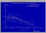
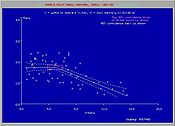
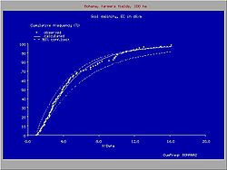
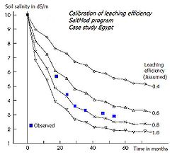
Simpler models, like SaltMod
SaltMod
SaltMod is computer program for the prediction of the salinity of soil moisture, groundwater and drainage water, the depth of the watertable, and the drain discharge in irrigated agricultural lands, using different hydrologic conditions, varying water management options, including the use of...
, based on seasonal water and soil balances and an empirical capillary rise function, are also available. They are useful for long-term salinity predictions in relation to irrigation
Irrigation
Irrigation may be defined as the science of artificial application of water to the land or soil. It is used to assist in the growing of agricultural crops, maintenance of landscapes, and revegetation of disturbed soils in dry areas and during periods of inadequate rainfall...
and drainage
Drainage
Drainage is the natural or artificial removal of surface and sub-surface water from an area. Many agricultural soils need drainage to improve production or to manage water supplies.-Early history:...
practices.
Spatial variations owing to variations in topography
Topography
Topography is the study of Earth's surface shape and features or those ofplanets, moons, and asteroids...
can be simulated and predicted using salinity cum groundwater model
Groundwater model
Groundwater models are computer models of groundwater flow systems, and are used by hydrogeologists. Groundwater models are used to simulate and predict aquifer conditions.-Characteristics:...
s, like SahysMod
SahysMod
SahysMod is a computer program for the prediction of the salinity of soil moisture, groundwater and drainage water, the depth of the watertable, and the drain discharge in irrigated agricultural lands, using different hydrogeologic and aquifer conditions, varying water management options, including...
.