

Infiltration (hydrology)
Encyclopedia
Soil
Soil is a natural body consisting of layers of mineral constituents of variable thicknesses, which differ from the parent materials in their morphological, physical, chemical, and mineralogical characteristics...
. Infiltration rate in soil science
Soil science
Soil science is the study of soil as a natural resource on the surface of the earth including soil formation, classification and mapping; physical, chemical, biological, and fertility properties of soils; and these properties in relation to the use and management of soils.Sometimes terms which...
is a measure of the rate at which soil is able to absorb rainfall or irrigation
Irrigation
Irrigation may be defined as the science of artificial application of water to the land or soil. It is used to assist in the growing of agricultural crops, maintenance of landscapes, and revegetation of disturbed soils in dry areas and during periods of inadequate rainfall...
. It is measured in inches per hour or millimeters per hour. The rate decreases as the soil becomes saturated. If the precipitation rate exceeds the infiltration rate, runoff
Surface runoff
Surface runoff is the water flow that occurs when soil is infiltrated to full capacity and excess water from rain, meltwater, or other sources flows over the land. This is a major component of the water cycle. Runoff that occurs on surfaces before reaching a channel is also called a nonpoint source...
will usually occur unless there is some physical barrier. It is related to the saturated hydraulic conductivity
Hydraulic conductivity
Hydraulic conductivity, symbolically represented as K, is a property of vascular plants, soil or rock, that describes the ease with which water can move through pore spaces or fractures. It depends on the intrinsic permeability of the material and on the degree of saturation...
of the near-surface soil. The rate of infiltration can be measured using an infiltrometer
Infiltrometer
Infiltrometer is a device used to measure the rate of water infiltration into soil or other porous media. Commonly used infiltrometers are single ring or double ring infiltrometer, and also disc permeameter....
.
Introduction
Infiltration is governed by two forces: gravity and capillary actionCapillary action
Capillary action, or capilarity, is the ability of a liquid to flow against gravity where liquid spontanously rise in a narrow space such as between the hair of a paint-brush, in a thin tube, or in porous material such as paper or in some non-porous material such as liquified carbon fiber, or in a...
. While smaller pores offer greater resistance to gravity, very small pores pull water through capillary action in addition to and even against the force of gravity.
The rate of infiltration is affected by soil characteristics including ease of entry, storage capacity, and transmission rate through the soil. The soil texture
Soil texture
Soil texture is a qualitative classification tool used in both the field and laboratory to determine classes for agricultural soils based on their physical texture. The classes are distinguished in the field by the 'textural feel' which can be further clarified by separating the relative...
and structure, vegetation types and cover, water content of the soil, soil temperature
Temperature
Temperature is a physical property of matter that quantitatively expresses the common notions of hot and cold. Objects of low temperature are cold, while various degrees of higher temperatures are referred to as warm or hot...
, and rainfall intensity all play a role in controlling infiltration rate and capacity. For example, coarse-grained sand
Sand
Sand is a naturally occurring granular material composed of finely divided rock and mineral particles.The composition of sand is highly variable, depending on the local rock sources and conditions, but the most common constituent of sand in inland continental settings and non-tropical coastal...
y soils have large spaces between each grain and allow water to infiltrate quickly. Vegetation creates more porous soils by both protecting the soil from pounding rainfall, which can close natural gaps between soil particles, and loosening soil through root action. This is why forest
Forest
A forest, also referred to as a wood or the woods, is an area with a high density of trees. As with cities, depending where you are in the world, what is considered a forest may vary significantly in size and have various classification according to how and what of the forest is composed...
ed areas have the highest infiltration rates of any vegetative types.
The top layer of leaf litter that is not decomposed protects the soil from the pounding action of rain; without this the soil can become far less permeable. In chapparal vegetated areas, the hydrophobic oils in the succulent leaves can be spread over the soil surface with fire, creating large areas of hydrophobic soil
Hydrophobic soil
Hydrophobic soil - soil that is hydrophobic - causes water to collect on the soil surface rather than infiltrate into the ground. Wild fires generally cause soils to be hydrophobic temporarily, which increases water repellency, surface runoff and erosion in post-burn sites...
. Other conditions that can lower infiltration rates or block them include dry plant litter
Plant litter
Plant litter, leaf litter or tree litter is dead plant material, such as leaves, bark, needles, and twigs, that has fallen to the ground. Litter provides habitat for small animals, fungi, and plants, and the material may be used to construct nests. As litter decomposes, nutrients are released to...
that resists re-wetting, or frost
Frost
Frost is the solid deposition of water vapor from saturated air. It is formed when solid surfaces are cooled to below the dew point of the adjacent air as well as below the freezing point of water. Frost crystals' size differ depending on time and water vapour available. Frost is also usually...
. If soil is saturated at the time of an intense freezing period, the soil can become a concrete frost on which almost no infiltration would occur. Over an entire watershed
Drainage basin
A drainage basin is an extent or an area of land where surface water from rain and melting snow or ice converges to a single point, usually the exit of the basin, where the waters join another waterbody, such as a river, lake, reservoir, estuary, wetland, sea, or ocean...
, there are likely to be gaps in the concrete frost or hydrophobic soil where water can infiltrate.
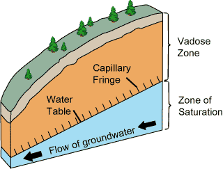
Once water has infiltrated the soil it remains in the soil, percolates down to the ground water table, or becomes part of the subsurface runoff process.
Process
The process of infiltration can continue only if there is room available for additional water at the soil surface. The available volume for additional water in the soil depends on the porosity of the soil and the rate at which previously infiltrated water can move away from the surface through the soil. The maximum rate that water can enter a soil in a given condition is the infiltration capacity. If the arrival of the water at the soil surface is less than the infiltration capacity, all of the water will infiltrate. If rainfall intensity at the soil surface occurs at a rate that exceeds the infiltration capacity, ponding begins and is followed by runoff
Surface runoff
Surface runoff is the water flow that occurs when soil is infiltrated to full capacity and excess water from rain, meltwater, or other sources flows over the land. This is a major component of the water cycle. Runoff that occurs on surfaces before reaching a channel is also called a nonpoint source...
over the ground surface, once depression storage is filled. This runoff is called Horton overland flow. The entire hydrologic system of a watershed is sometimes analyzed using hydrology transport models, mathematical model
Mathematical model
A mathematical model is a description of a system using mathematical concepts and language. The process of developing a mathematical model is termed mathematical modeling. Mathematical models are used not only in the natural sciences and engineering disciplines A mathematical model is a...
s that consider infiltration, runoff and channel flow to predict river flow rates and stream water quality
Water pollution
Water pollution is the contamination of water bodies . Water pollution occurs when pollutants are discharged directly or indirectly into water bodies without adequate treatment to remove harmful compounds....
.
Research findings
Robert E. Horton
Robert E. Horton
Robert Elmer Horton was an American ecologist and soil scientist, considered by many to be the father of modern hydrology....
(1933) suggested that infiltration capacity rapidly declines during the early part of a storm and then tends towards an approximately constant value after a couple of hours for the remainder of the event. Previously infiltrated water fills the available storage spaces and reduces the capillary forces drawing water into the pores. Clay
Clay
Clay is a general term including many combinations of one or more clay minerals with traces of metal oxides and organic matter. Geologic clay deposits are mostly composed of phyllosilicate minerals containing variable amounts of water trapped in the mineral structure.- Formation :Clay minerals...
particles in the soil may swell as they become wet and thereby reduce the size of the pores. In areas where the ground is not protected by a layer of forest litter, raindrops can detach soil particles from the surface and wash fine particles into surface pores where they can impede the infiltration process.
Infiltration in wastewater collection
WastewaterWastewater
Wastewater is any water that has been adversely affected in quality by anthropogenic influence. It comprises liquid waste discharged by domestic residences, commercial properties, industry, and/or agriculture and can encompass a wide range of potential contaminants and concentrations...
collection systems consist of a set of lines, junctions and lift stations to convey sewage
Sewage
Sewage is water-carried waste, in solution or suspension, that is intended to be removed from a community. Also known as wastewater, it is more than 99% water and is characterized by volume or rate of flow, physical condition, chemical constituents and the bacteriological organisms that it contains...
to a wastewater treatment plant. When these lines are compromised by rupture, cracking or tree root invasion
Root invasion
Root invasion is the incursion of plant roots with undesirable impacts.-Biological:When the roots of neighboring plants or trees, invade the area of other plants there will be decline in the health, and eventual wasting of the plant whose space is being invaded. In planted areas periodical...
, infiltration of stormwater often occurs. This circumstance can lead to a sanitary sewer overflow
Sanitary sewer overflow
Sanitary sewer overflow is a condition whereby untreated sewage is discharged into the environment prior to reaching treatment facilities thereby escaping wastewater treatment. When caused by rainfall it is also known as wet weather overflow. It is primarily meaningful in developed countries,...
, or discharge of untreated sewage to the environment.
Infiltration calculation methods
Infiltration is a component of the general mass balance hydrologic budget. There are several ways to estimate the volume and/or the rate of infiltration of water into a soil. Three excellent estimation methods are the Green-Ampt method, SCS method, Horton's method, and Darcy's law.General hydrologic budget
The general hydrologic budget, with all the components, with respect to infiltration F. Given all the other variables and infiltration is the only unknown, simple algebra solves the infiltration question.
where
- F is infiltration, which can be measured as a volume or length;
 is the boundary input, which is essentially the output watershed from adjacent, directly connected impervious areas;
 is the boundary output, which is also related to surface runoff, R, depending on where one chooses to define the exit point or points for the boundary output;
 - P is precipitationPrecipitation (meteorology)In meteorology, precipitation In meteorology, precipitation In meteorology, precipitation (also known as one of the classes of hydrometeors, which are atmospheric water phenomena is any product of the condensation of atmospheric water vapor that falls under gravity. The main forms of precipitation...
; - E is evaporationEvaporationEvaporation is a type of vaporization of a liquid that occurs only on the surface of a liquid. The other type of vaporization is boiling, which, instead, occurs on the entire mass of the liquid....
; - T is transpirationTranspirationTranspiration is a process similar to evaporation. It is a part of the water cycle, and it is the loss of water vapor from parts of plants , especially in leaves but also in stems, flowers and roots. Leaf surfaces are dotted with openings which are collectively called stomata, and in most plants...
; - ET is evapotranspirationEvapotranspirationEvapotranspiration is a term used to describe the sum of evaporation and plant transpiration from the Earth's land surface to atmosphere. Evaporation accounts for the movement of water to the air from sources such as the soil, canopy interception, and waterbodies...
; - S is the storage through either retentionRetention basinA retention basin is used to manage stormwater runoff to prevent flooding and downstream erosion, and improve water quality in an adjacent river, stream, lake or bay. Sometimes called a wet pond or wet detention basin, it is an artificial lake with vegetation around the perimeter, and includes a...
or detention areasDetention basinA detention basin is a stormwater management facility installed on, or adjacent to, tributaries of rivers, streams, lakes or bays that is designed to protect against flooding and, in some cases, downstream erosion by storing water for a limited period of a time. These basins are also called "dry...
; is the initial abstraction, which is the short term surface storage such as puddles or even possibly detention pondsDetention basinA detention basin is a stormwater management facility installed on, or adjacent to, tributaries of rivers, streams, lakes or bays that is designed to protect against flooding and, in some cases, downstream erosion by storing water for a limited period of a time. These basins are also called "dry...
depending on size; - R is surface runoffSurface runoffSurface runoff is the water flow that occurs when soil is infiltrated to full capacity and excess water from rain, meltwater, or other sources flows over the land. This is a major component of the water cycle. Runoff that occurs on surfaces before reaching a channel is also called a nonpoint source...
.
The only note on this method is one must be wise about which variables to use and which to omit, for doubles can easily be encountered. An easy example of double counting variables is when the evaporation, E, and the transpiration, T, are placed in the equation as well as the evapotranspiration, ET. ET has included in it T as well as a portion of E.
Green-Ampt
Named for two men; Green and Ampt. The Green-Ampt method of infiltration estimation accounts for many variables that other methods, such as Darcy's law, do not. It is a function of the soil suction head, porosity, hydraulic conductivity and time.

where
 is wetting front soil suction head;
 is water content
Water content
Water content or moisture content is the quantity of water contained in a material, such as soil , rock, ceramics, fruit, or wood. Water content is used in a wide range of scientific and technical areas, and is expressed as a ratio, which can range from 0 to the value of the materials' porosity at...
;
 is Hydraulic conductivity
Hydraulic conductivity
Hydraulic conductivity, symbolically represented as K, is a property of vascular plants, soil or rock, that describes the ease with which water can move through pore spaces or fractures. It depends on the intrinsic permeability of the material and on the degree of saturation...
;
 is the total volume already infiltrated.
Once integrated, one can easily choose to solve for either volume of infiltration or instantaneous infiltration rate:
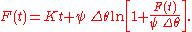
Using this model one can find the volume easily by solving for
 . However the variable being solved for is in the equation itself so when solving for this one must set the variable in question to converge on zero, or another appropriate constant. A good first guess for
  is the larger value of either
  or
or  . The only note on using this formula is that one must assume that
  , the water head or the depth of ponded water above the surface, is negligible. Using the infiltration volume from this equation one may then substitute
  into the corresponding infiltration rate equation below to find the instantaneous infiltration rate at the time,
  ,
,  was measured.
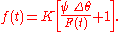
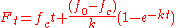
Horton's equation
Named after the same Robert E. HortonRobert E. Horton
Robert Elmer Horton was an American ecologist and soil scientist, considered by many to be the father of modern hydrology....
mentioned above, Horton's equation is another viable option when measuring ground infiltration rates or volumes. It is an empirical formula that says that infiltration starts at a constant rate,
 , and is decreasing exponentially with time,
  . After some time when the soil saturation level reaches a certain value, the rate of infiltration will level off to the rate
  .
.
Where
 is the infiltration rate at time t;
 is the initial infiltration rate or maximum infiltration rate;
 is the constant or equilibrium infiltration rate after the soil has been saturated or minimum infiltration rate;
 is the decay constant specific to the soil.
The other method of using Horton's equation is as below. It can be used to find the total volume of infiltration, F, after time t.
Kostiakov equation
Named after its founder Kostiakov is an empirical equation which assumes that the intake rate declines over time according to a power function.
Where
 and
and  are empirical parameters.
The major limitation of this expression is its reliance on the zero final intake rate. In most cases the infilration rate instead approaches a finite steady value, which in some cases may occur after short periods of time. The Kostiakov-Lewis variant, also known as the "Modified Kostiakov" equation corrects for this by adding a steady intake term to the original equation.

in integrated form the cumulative volume is expressed as:

Where
 approximates, but does not necessarily equate to the final infiltration rate of the soil.
Darcy's law
This method used for infiltration is using a simplified version of Darcy's lawDarcy's law
Darcy's law is a phenomenologically derived constitutive equation that describes the flow of a fluid through a porous medium. The law was formulated by Henry Darcy based on the results of experiments on the flow of water through beds of sand...
. In this model the ponded water is assumed to be equal to
 and the head of dry soil that exists below the depth of the wetting front soil suction head is assumed to be equal to
  .
.
where
 is wetting front soil suction head
 is the depth of ponded water above the ground surface;
 is the hydraulic conductivity
Hydraulic conductivity
Hydraulic conductivity, symbolically represented as K, is a property of vascular plants, soil or rock, that describes the ease with which water can move through pore spaces or fractures. It depends on the intrinsic permeability of the material and on the degree of saturation...
;
- L is the total depth of subsurface ground in question.
In summary all of these equations should provide a relatively accurate assessment of the infiltration characteristics of the soil in question.
See also
- Discharge (hydrology)Discharge (hydrology)In hydrology, discharge is the volume rate of water flow, including any suspended solids , dissolved chemical species and/or biologic material , which is transported through a given cross-sectional area...
- Hydrophobic soilHydrophobic soilHydrophobic soil - soil that is hydrophobic - causes water to collect on the soil surface rather than infiltrate into the ground. Wild fires generally cause soils to be hydrophobic temporarily, which increases water repellency, surface runoff and erosion in post-burn sites...
- Natural Resources Conservation ServiceNatural Resources Conservation ServiceThe Natural Resources Conservation Service , formerly known as the Soil Conservation Service , is an agency of the United States Department of Agriculture that provides technical assistance to farmers and other private landowners and managers.Its name was changed in 1994 during the Presidency of...
- Permeability (fluid)Permeability (fluid)Permeability in fluid mechanics and the earth sciences is a measure of the ability of a porous material to allow fluids to pass through it.- Units :...
- Drainage system (agriculture)Drainage system (Agriculture)An agricultural drainage system is a system by which the water level on or in the soil is controlled to enhance agricultural crop production.-Classification:Figure 1 classifies the various types of drainage systems...
- Groundwater recharge
- Runoff curve number
- Sustainable urban drainage systemsSustainable urban drainage systemsSustainable Drainage Systems , sometimes known as Sustainable Urban Drainage Systems , are designed to reduce the potential impact of new and existing developments with respect to surface water drainage discharges.-Background:...
- Storm Water Management ModelStorm Water Management ModelThe United States Environmental Protection Agency Storm Water Management Model is a dynamic rainfall-runoff-subsurface runoff simulation model used for single-event to long-term simulation of the surface/subsurface hydrology quantity and quality from primarily urban/suburban areas...