

Salar de Uyuni
Encyclopedia

Potosí Department
Potosí Department is a department in southwestern Bolivia. It comprises 118,218 km² with 709,013 inhabitants . The capital is the city of Potosí....
and Oruro
Oruro Department
Oruro is a department in Bolivia, with an area of 53,588 km². Its capital is the city of Oruro. At the time of census 2001 it had a population of 391,870.- Provinces of Oruro :...
departments
Departments of Bolivia
Bolivia is divided into nine departments . Each of the departments is subdivided into provinces , which are further subdivided into municipalities ....
in southwest Bolivia
Bolivia
Bolivia officially known as Plurinational State of Bolivia , is a landlocked country in central South America. It is the poorest country in South America...
, near the crest of the Andes
Andes
The Andes is the world's longest continental mountain range. It is a continual range of highlands along the western coast of South America. This range is about long, about to wide , and of an average height of about .Along its length, the Andes is split into several ranges, which are separated...
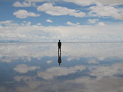
, and is elevated 3656 metres (11,994.8 ft) above the mean sea level. The Salar was formed as a result of transformations between several prehistoric lakes. It is covered by a few meters of salt crust, which has an extraordinary flatness with the average altitude variations within one meter over the entire area of the Salar. The crust serves as a source of salt and covers a pool of brine
Brine
Brine is water, saturated or nearly saturated with salt .Brine is used to preserve vegetables, fruit, fish, and meat, in a process known as brining . Brine is also commonly used to age Halloumi and Feta cheeses, or for pickling foodstuffs, as a means of preserving them...
, which is exceptionally rich in lithium
Lithium
Lithium is a soft, silver-white metal that belongs to the alkali metal group of chemical elements. It is represented by the symbol Li, and it has the atomic number 3. Under standard conditions it is the lightest metal and the least dense solid element. Like all alkali metals, lithium is highly...
. It contains 50 to 70% of the world's lithium reserves, which is in the process of being extracted. The large area, clear skies and exceptional surface flatness make the Salar an ideal object for calibrating the altimeter
Altimeter
An altimeter is an instrument used to measure the altitude of an object above a fixed level. The measurement of altitude is called altimetry, which is related to the term bathymetry, the measurement of depth underwater.-Pressure altimeter:...
s of the Earth observation satellites. The Salar serves as the major transport route across the Bolivian Altiplano
Altiplano
The Altiplano , in west-central South America, where the Andes are at their widest, is the most extensive area of high plateau on Earth outside of Tibet...
and is a major breeding ground for several species of pink flamingo
Flamingo
Flamingos or flamingoes are gregarious wading birds in the genus Phoenicopterus , the only genus in the family Phoenicopteridae...
s. Salar de Uyuni is also a climatological transitional zone, for towering tropical cumulus congestus and cumulus incus clouds that form in the eastern part of the massive salt flat during the summer, cannot permeate beyond the salt flat's considerably more arid western eges, near the Chilean border and the Atacama Desert
Atacama Desert
The Atacama Desert is a plateau in South America, covering a strip of land on the Pacific coast, west of the Andes mountains. It is, according to NASA, National Geographic and many other publications, the driest desert in the world...
.
Formation, geology and climate
Salar de Uyuni is part of the Altiplano of Bolivia in South America. The Altiplano is a high plateau, which was formed during uplift of the Andes mountains. The plateau includes fresh and saltwater lakes as well as salt flats and is surrounded by mountains with no drainage outlets.The geological history of the Salar is associated with a sequential transformation between several vast lakes. Some 30,000–42,000 years ago, the area was part of a giant prehistoric lake, Lake Minchin. Its age was estimated from radiocarbon dating
Radiocarbon dating
Radiocarbon dating is a radiometric dating method that uses the naturally occurring radioisotope carbon-14 to estimate the age of carbon-bearing materials up to about 58,000 to 62,000 years. Raw, i.e. uncalibrated, radiocarbon ages are usually reported in radiocarbon years "Before Present" ,...
of shells from outcropping sediment
Sediment
Sediment is naturally occurring material that is broken down by processes of weathering and erosion, and is subsequently transported by the action of fluids such as wind, water, or ice, and/or by the force of gravity acting on the particle itself....
s and carbonate reefs
Carbonate platform
A carbonate platform is a sedimentary body which possesses topographic relief, and is composed of autochthonous calcareous deposits . Platform growth is mediated by sessile organisms whose skeletons build up the reef or by organisms which induce carbonate precipitation through their metabolism...
and varies between reported studies. Lake Minchin (named after the Juan B. Minchin of Oruro) later transformed into paleolake Tauca having a maximal depth of 140 metres (459.3 ft), and an estimated age of 13,000–18,000 or 14,900–26,100 years depending on the source. The youngest prehistoric lake was Coipasa, which was radiocarbon dated to 11,500–13,400 years. When it dried, it left behind two modern lakes, Poopó Lake and Uru Uru Lake
Lago Uru Uru
Lake Uru Uru is a lake in the Oruro Department in Bolivia. It is fed by the Desaguadero River. It is situated at an elevation of 3686 m, its surface area is 214 km²....
, and two major salt deserts, Salar de Coipasa
Lago Coipasa
Lago Coipasa or Salar de coipasa is a lake in Atahuallpa Province, Oruro Department, Bolivia. At an elevation of 3657 m, its surface area is 806 km²...
and the larger Salar de Uyuni. Salar de Uyini spreads over 10582 sqkm, which is roughly 25 times the size of the Bonneville Salt Flats in the United States. Lake Poopó is a neighbor of the much larger lake Titicaca
Lake Titicaca
Lake Titicaca is a lake located on the border of Peru and Bolivia. It sits 3,811 m above sea level, making it the highest commercially navigable lake in the world...
. During the wet season, Titicaca overflows and discharges into Poopó, which, in turn, floods Salar De Coipasa and Salar de Uyuni.
Underneath the surface of the Salar is a lake of brine
Brine
Brine is water, saturated or nearly saturated with salt .Brine is used to preserve vegetables, fruit, fish, and meat, in a process known as brining . Brine is also commonly used to age Halloumi and Feta cheeses, or for pickling foodstuffs, as a means of preserving them...
2 to 20 m (6.6 to 65.6 ft) deep. The brine is a saturated solution of sodium chloride
Sodium chloride
Sodium chloride, also known as salt, common salt, table salt or halite, is an inorganic compound with the formula NaCl. Sodium chloride is the salt most responsible for the salinity of the ocean and of the extracellular fluid of many multicellular organisms...
, lithium chloride
Lithium chloride
Lithium chloride is a chemical compound with the formula LiCl. The salt is a typical ionic compound, although the small size of the Li+ ion gives rise to properties not seen for other alkali metal chlorides, such as extraordinary solubility in polar solvents and its hygroscopic...
and magnesium chloride
Magnesium chloride
Magnesium chloride is the name for the chemical compounds with the formulas MgCl2 and its various hydrates MgCl2x. These salts are typical ionic halides, being highly soluble in water. The hydrated magnesium chloride can be extracted from brine or sea water...
in water. It is covered with a solid salt crust with a thickness varying between tens of centimeters to a few meters. The center of the Salar contains a few "islands", which are the remains of the tops of ancient volcanoes which were submerged during the era of lake Minchin. They include unusual and fragile coral-like structures and deposits that often consist of fossils and algae.
The area has a relatively stable average temperature with a peak at 21 °C (69.8 °F) in November–January and a low of 13 °C (55.4 °F) in June. The nights are however cold all through the year with temperatures between -9 C. The relative humidity is rather low and constant throughout the year at 30–45 %. The rainfall is also low at 1 – per month between April and November, but it may increase up to 70 millimetres (2.8 in) in January. However, except for January, even in the rainy season the number of rainy days is below 5 per month.
Economic influence
The Salar contains large amounts of sodiumSodium
Sodium is a chemical element with the symbol Na and atomic number 11. It is a soft, silvery-white, highly reactive metal and is a member of the alkali metals; its only stable isotope is 23Na. It is an abundant element that exists in numerous minerals, most commonly as sodium chloride...
, potassium
Potassium
Potassium is the chemical element with the symbol K and atomic number 19. Elemental potassium is a soft silvery-white alkali metal that oxidizes rapidly in air and is very reactive with water, generating sufficient heat to ignite the hydrogen emitted in the reaction.Potassium and sodium are...
, lithium
Lithium
Lithium is a soft, silver-white metal that belongs to the alkali metal group of chemical elements. It is represented by the symbol Li, and it has the atomic number 3. Under standard conditions it is the lightest metal and the least dense solid element. Like all alkali metals, lithium is highly...
and magnesium
Magnesium
Magnesium is a chemical element with the symbol Mg, atomic number 12, and common oxidation number +2. It is an alkaline earth metal and the eighth most abundant element in the Earth's crust and ninth in the known universe as a whole...
(all in the chloride forms of NaCl, KCl, LiCl and MgCl2, respectively), as well as borax
Borax
Borax, also known as sodium borate, sodium tetraborate, or disodium tetraborate, is an important boron compound, a mineral, and a salt of boric acid. It is usually a white powder consisting of soft colorless crystals that dissolve easily in water.Borax has a wide variety of uses...
. Of those, lithium is arguably most important as it is a vital component of many electric batteries
Lithium battery
Lithium batteries are disposable batteries that have lithium metal or lithium compounds as an anode. Depending on the design and chemical compounds used, lithium cells can produce voltages from 1.5 V to about 3.7 V, over twice the voltage of an ordinary zinc–carbon battery or alkaline battery...
. With estimated 9000000 tonnes (8,857,831.8 LT), Bolivia holds about 43% of the world's lithium reserves; most of those are located in the Salar de Uyuni. Lithium is concentrated in the brine under the salt crust at a relatively high concentration of about 0.3%. It is also present in the top layers of the porous halite
Halite
Halite , commonly known as rock salt, is the mineral form of sodium chloride . Halite forms isometric crystals. The mineral is typically colorless or white, but may also be light blue, dark blue, purple, pink, red, orange, yellow or gray depending on the amount and type of impurities...
body lying under the brine; however the liquid brine is easier to extract, by boring into the crust and pumping out the brine. The brine distribution has been monitored by the Landsat
Landsat program
The Landsat program is the longest running enterprise for acquisition of satellite imagery of Earth. On July 26, 1972 the Earth Resources Technology Satellite was launched. This was eventually renamed to Landsat. The most recent, Landsat 7, was launched on April 15, 1999. The instruments on the...
satellite and confirmed in ground drilling tests. Following those findings, an American-based international corporation has invested $137 million to develop lithium extraction. However, lithium extraction in the 1980s and 1990s by foreign companies met strong opposition of the local community. Despite their poverty, locals believed that the money infused by mining would not reach them. There is currently no mining plant at the site, and the Bolivian government doesn't want to allow exploitation by foreign corporations. Instead, it intends to build its own pilot plant with a modest annual production of 1200 tonnes (1,181 LT) of lithium and to increase it to 30000 tonnes (29,526.1 LT) tonnes by 2012.
Salar de Uyuni is estimated to contain 10 billion tonnes (9.8 billion LT; 11 billion ST) of salt
Salt
In chemistry, salts are ionic compounds that result from the neutralization reaction of an acid and a base. They are composed of cations and anions so that the product is electrically neutral...
, of which less than 25000 tonnes (24,605.1 LT) is extracted annually. All miners working in the Salar belong to Colchani's cooperative.
Because of its location, large area and flatness, the Salar is a major car transport route across the Bolivian Altiplano.
Name
Salar is salt flat in Spanish and Uyuni originates from the Aymara languageAymara language
Aymara is an Aymaran language spoken by the Aymara people of the Andes. It is one of only a handful of Native American languages with over three million speakers. Aymara, along with Quechua and Spanish, is an official language of Peru and Bolivia...
and means a pen
Pen (enclosure)
A pen is an enclosure for holding livestock. The term describes multiple types of enclosures that may confine one or many animals. Construction and terminology varies depending on region of the world, purpose, animal species to be confined, local materials used, and cultural tradition...
(enclosure). Thus Salar de Uyuni can be loosely translated as a salt flat with enclosures, the latter possibly referring to the "islands" of the Salar. Uyuni
Uyuni
Uyuni is a city in the southwest of Bolivia. It primarily serves as a gateway for tourists visiting the world's largest salt flats, the nearby Salar de Uyuni.-Origin:...
is also the name for a town of 10,600 people, which serves as a gateway for tourists visiting the Salar.
Aymara legend tells that the mountains Tunupa, Kusku and Kusina, which surround the Salar, were giant people. Tunupa married Kusku, but Kusku ran away from her with Kusina. Grieving Tunupa started to cry while breast-feeding her son. Her tears mixed with milk and formed the Salar. Many locals consider the Tunupa an important deity
Deity
A deity is a recognized preternatural or supernatural immortal being, who may be thought of as holy, divine, or sacred, held in high regard, and respected by believers....
and say that the place should be called Salar de Tunupa rather than Salar de Uyuni.
Flora and fauna
The Salar is virtually devoid of any wild life and vegetation. The latter is dominated by giant cacti (EchinopsisEchinopsis
Echinopsis is a large genus of cacti native to South America, sometimes known as hedgehog cacti, sea-urchin cactus or Easter lily cactus. One small species, E. chamaecereus, is known as the peanut cactus. The 128 species range from large and treelike types to small globose cacti...
atacamensis pasacana, Echinopsis tarijensis, etc.). They grow at a rate of about 1 centimetre (0.393700787401575 in) per year to a length of about 12 metres (39.4 ft). Other shrubs include Pilaya, which is used by locals to cure catarrh
Catarrh
Catarrh is a disorder of inflammation of the mucous membranes in one of the airways or cavities of the body. It can result in a thick exudate of mucus and white blood cells caused by the swelling of the mucous membranes in the head in response to an infection...
, and Thola (Baccharis
Baccharis
Baccharis is a genus of perennials and shrubs in the aster family . They are commonly known as baccharises but sometimes referred to as "brooms", because many members have small thin leaves resembling the true brooms. They are not at all related to these however, but belong to an entirely...
dracunculifolia), which is burned as a fuel. Also present are quinoa
Quinoa
Quinoa , a species of goosefoot , is a grain-like crop grown primarily for its edible seeds. It is a pseudocereal rather than a true cereal, or grain, as it is not a member of the grass family...
plants and quenua bushes.
Every November, Salar de Uyuni is the breeding grounds for three species of pink South American flamingo
Flamingo
Flamingos or flamingoes are gregarious wading birds in the genus Phoenicopterus , the only genus in the family Phoenicopteridae...
s: the Chilean
Chilean Flamingo
The Chilean Flamingo is a large species closely related to Caribbean Flamingo and Greater Flamingo, with which it was sometimes considered conspecific...
, Andean
Andean Flamingo
The Andean flamingo, or Phoenicopterus andinus, is one of the rarest flamingos in the world. It has a pale pink body with brighter upperparts, deep vinaceous-pink lower neck, breast, and wing-coverts. It is the only flamingo species with yellow legs and three-toed feet. The bill of the Andean...
and rare James's Flamingo
James's Flamingo
James's Flamingo is also known as the Puna Flamingo. Named for Harry Berkeley James, it populates the high altitudes of Andean plateaus of Peru, Chile, Bolivia and Argentina. It is closely related to the Andean Flamingo, and the two make up the genus Phoenicoparrus...
s, their color presumably originating from feeding on pink algae
Algae
Algae are a large and diverse group of simple, typically autotrophic organisms, ranging from unicellular to multicellular forms, such as the giant kelps that grow to 65 meters in length. They are photosynthetic like plants, and "simple" because their tissues are not organized into the many...
. There are about 80 of other bird species present, including the horned coot
Horned Coot
The Horned Coot is a species of bird found at lakes in the altiplano of north-western Argentina, south-western Bolivia, and north-eastern Chile. It is almost entirely restricted to altitudes of 3000-5200 m.a.s.l., but has occasionally been recorded at lower altitudes...
, the Andean goose
Andean Goose
The Andean Goose, Chloephaga melanoptera, is a member of the duck, goose and swan family Anatidae. It is in the shelduck subfamily Tadorninae.It is resident around lakes and marshes in the high Andes, usually well above 3000 m...
and the Andean Hillstar
Andean Hillstar
The Andean Hillstar is a species of hummingbird in the Trochilidae family. It is found in grassland, scrub and woodland in the Altiplano of southern Peru, Bolivia, northern Chile, and north-western Argentina...
. Andean fox (culpeo
Culpeo
The culpeo , sometimes known as the culpeo zorro or Andean fox , is a South American species of wild dog. It is the second largest native canid on the continent after the maned wolf. In its appearance it bears many similarities to the widely recognized red fox...
) is a representative animal, and the "islands" of Salar (in particular the Incahuasi island, which is also called Isla del Pescadores) host a colony of rabbit-like viscacha
Viscacha
Viscachas or vizcachas are rodents of two genera in the family Chinchillidae. They are closely related to chinchillas, and look similar to rabbits...
s.
Hotels
Salar de Uyuni attracts tourists from around the world. As it is located far from the cities, a number of hotels have been built in the area. Due to lack of conventional construction materials, many of them are almost entirely (walls, roof, furniture) built with salt blocks cut from the Salar. The first such hotel was erected in 1993-1995 in the middle of the salt flat, and soon became a popular tourist destination. However, its location in the center of a desert produced sanitary problems, as most waste had to be collected manually. Mismanagement caused serious environmental pollution and the hotel had to be dismantled in 2002. New salt hotels were built near the periphery of the Salar, closer to roads, in full compliance with environmental rules.Train cemetery
One major tourist attraction is an antique train cemetery. It is 3 kilometres (1.9 mi) outside Uyuni and is connected to it by the old train tracks. The town served in the past as a distribution hub for the trains carrying minerals enroute to Pacific OceanPacific Ocean
The Pacific Ocean is the largest of the Earth's oceanic divisions. It extends from the Arctic in the north to the Southern Ocean in the south, bounded by Asia and Australia in the west, and the Americas in the east.At 165.2 million square kilometres in area, this largest division of the World...
ports. The rail lines were built by British engineers arriving near the end of the 19th century and formed a sizeable community in Uyuni. The engineers were invited by British-sponsored Antofagasta and Bolivia Railway Companies, which is now Ferrocarril de Antofagasta a Bolivia
Ferrocarril de Antofagasta a Bolivia
The Ferrocarril de Antofagasta a Bolivia is a private railway operating in the northern provinces of Chile. It is notable in that it was one of the earliest railways built to the gauge of , with a route that climbed from sea level to over , while handling goods traffic totaling near 2 million tons...
. The rail construction started in 1888 and ended in 1892. It was encouraged by Bolivian President Aniceto Arce
Aniceto Arce
Aniceto Arce Ruiz was President of Bolivia from 1888 until 1892. The Aniceto Arce Province is named after him. Arce was a native of Tarija but was educated as a lawyer and resided most of his life in Sucre, where he became one of the country's foremost silver-mining tycoons...
, who believed Bolivia would flourish with a good transport system, but it was also constantly sabotaged by the local Aymara indigenous Indians who saw it as an intrusion into their lives. The trains were mostly used by the mining companies. In the 1940s, the mining industry collapsed, partly because of mineral depletion. Many trains were abandoned, producing the train cemetery. There are proposals to build a museum from the cemetery.
Satellite calibration
Albedo
Albedo , or reflection coefficient, is the diffuse reflectivity or reflecting power of a surface. It is defined as the ratio of reflected radiation from the surface to incident radiation upon it...
) for ultraviolet light is relatively high at 0.69 and shows variations of only a few percent during the daytime. The combination of all these features makes Salar de Uyuni about five times better for satellite calibration than the surface of an ocean. Using Salar de Uyuni as the target, ICESat has already achieved the short-term elevation measurement accuracy of below 2 centimetre (0.78740157480315 in).
With the use of modern GPS
Global Positioning System
The Global Positioning System is a space-based global navigation satellite system that provides location and time information in all weather, anywhere on or near the Earth, where there is an unobstructed line of sight to four or more GPS satellites...
technology, it can now be proved that the Salar de Uyuni is not perfectly flat. New measurements revealed previously missed features resembling ridges, hills, and valleys measuring only millimeters in height. They originate from the variation in material density, and thus the gravitational force, beneath the Salar's sediments. Just as the ocean surface rises over denser seamounts, the salt flat surface also rises and falls to reflect the subsurface density variations.