Rule of twelfths
Encyclopedia

Rule of thumb
A rule of thumb is a principle with broad application that is not intended to be strictly accurate or reliable for every situation. It is an easily learned and easily applied procedure for approximately calculating or recalling some value, or for making some determination...
for estimating the height of the tide
Tide
Tides are the rise and fall of sea levels caused by the combined effects of the gravitational forces exerted by the moon and the sun and the rotation of the Earth....
at any time, given only the time and height of high and low water. This is important when navigating a boat
Boat
A boat is a watercraft of any size designed to float or plane, to provide passage across water. Usually this water will be inland or in protected coastal areas. However, boats such as the whaleboat were designed to be operated from a ship in an offshore environment. In naval terms, a boat is a...
or a ship
Ship
Since the end of the age of sail a ship has been any large buoyant marine vessel. Ships are generally distinguished from boats based on size and cargo or passenger capacity. Ships are used on lakes, seas, and rivers for a variety of activities, such as the transport of people or goods, fishing,...
in shallow water and when launching and retrieving boats on slipway
Slipway
A slipway, boat slip or just a slip, is a ramp on the shore by which ships or boats can be moved to and from the water. They are used for building and repairing ships and boats. They are also used for launching and retrieving small boats on trailers and flying boats on their undercarriage. The...
s on a tidal shore.
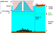
The rule assumes that the rate of flow of a tide
Tide
Tides are the rise and fall of sea levels caused by the combined effects of the gravitational forces exerted by the moon and the sun and the rotation of the Earth....
increases smoothly to a maximum halfway between high and low tide before smoothly decreasing to zero again and that the interval between low and high tides is approximately six hours.
The rule states that in the first hour after low tide the water level will rise by one twelfth of the range, in the second hour two twelfths, and so on according to the sequence - 1:2:3:3:2:1.
Example calculation
If a tide tableTide table
A tide table, sometimes called a tide chart, is used for tidal prediction and shows the daily times and height of high water and low water for a particular location...
gave us the information that tomorrow's low water would be at noon and that the water level at this time would be two metres above chart datum
Chart datum
A chart datum is the level of water that charted depths displayed on a nautical chart are measured from. A chart datum is generally a tidal datum; that is, a datum derived from some phase of the tide...
and further, that at the following high tide the water level would be 14 metres. We could work out the height of water at 3:00 p.m. as follows:
- The total increase in water level between low and high tide would be: 14 - 2 = 12 metres.
- In the first hour the water level would rise by 1 twelfth of the total (12 m) or: 1 m
- In the second hour the water level would rise by another 2 twelfths of the total (12 m) or: 2 m
- In the third hour the water level would rise by another 3 twelfths of the total (12 m) or: 3 m
- This gives us the increase in the water level by 3:00 p.m. as 6 metres.
This represents only the increase - the total depth of the water (relative to chart datum) will include the 2 m depth at low tide: 6 m + 2 m = 8 metres.
Obviously the calculation can be simplified by adding twelfths together and reducing the fraction beforehand i.e.
Rise of tide in three hours

Caveats
The rule is a rough approximation only and should be applied with great caution when used for navigational purposes. Officially produced tide tables should be used in preference whenever possible.The rule assumes that all tides behave in a regular manner, this is not true of some geographical locations, such as Poole Harbour
Poole Harbour
Poole Harbour is a large natural harbour in Dorset, southern England, with the town of Poole on its shores. The harbour is a drowned valley formed at the end of the last ice age and is the estuary of several rivers, the largest being the Frome. The harbour has a long history of human settlement...
or the Solent
Solent
The Solent is a strait separating the Isle of Wight from the mainland of England.The Solent is a major shipping route for passengers, freight and military vessels. It is an important recreational area for water sports, particularly yachting, hosting the Cowes Week sailing event annually...
where there are "double" high waters or Weymouth Bay
Weymouth Bay
Weymouth Bay is a sheltered bay on the south coast of England, in Dorset. It is protected from erosion by Chesil Beach and the Isle of Portland, and includes several beaches, notably Weymouth Beach, a gently curving arc of golden sand which stretches from the resort of Weymouth, along to the...
where there is a double low water.
The rule assumes that the period between high and low tides is six hours but this is an underestimate and can vary anyway.

