
.gif)
Route 28 (New Jersey)
Encyclopedia
Route 28 is a state highway
in the central part of New Jersey
, United States
that is 26.44 mi (42.55 km) long. Its western terminus is at U.S. Route 22
in Bridgewater Township
, Somerset County
while its eastern terminus is at Route 27 in Elizabeth
, Union County
. From its western terminus, Route 28 heads east through Raritan
, intersecting County Route 567
and then U.S. Route 202
and U.S. Route 206
at the Somerville Circle
before heading through the central part of Somerville
. Past Somerville, the route interchanges with Interstate 287
in Bridgewater Township before intersecting many 500-series county roads including County Route 525
and County Route 527
in Bound Brook
, County Route 529
in Dunellen
, Middlesex County
, County Route 531
in Plainfield
, Union County, and County Route 509
in Westfield
. Route 28 continues east, intersecting Route 59 and the Garden State Parkway
in Cranford
before heading to Elizabeth, where it crosses Route 439 before ending at Route 27. Route 28 is a two- to four-lane road its entire length that passes through suburban areas and runs within a close distance of New Jersey Transit
’s Raritan Valley Line
for much of its length.
Prior to 1927, Route 28 was known as Route 9, which was designated in 1917 to run from Phillipsburg
east to Elizabeth. With the creation of the U.S. Highway System in 1926, U.S. Route 22 was designated along with Route 28. In 1927, most of pre-1927 Route 9 became Route 28, with the exception of the route through Elizabeth, which became Route 27-28 Link as Route 28 followed present-day Route 439 to the Goethals Bridge
. Also legislated at this time was a spur
of Route 28 called Route S28, which became Route 18 in 1953. By 1941, U.S. Route 22 was moved off the Route 28 alignment in Phillipsburg, with U.S. Route 22 Alternate (now Route 122) taking its place, as well as east of Bridgewater Township, where it was realigned to follow Route 28-29 Link and Route 29 to Newark
. In 1953, the western terminus of Route 28 was moved to its current location to avoid the concurrencies
with U.S. Route 22 and U.S. Route 22 Alternate while the portion of the route in Elizabeth was realigned to replace Route 27-28 Link, with the former route becoming Route 439.
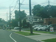 Route 28 begins at an interchange
with U.S. Route 22
in Bridgewater Township, Somerset County
, heading to the southeast on Easton Turnpike, a two-lane undivided road with a speed limit of 45 mph (72.4 km/h). Past this interchange, Easton Turnpike continues to the northwest as County Route 614. The route heads through predominantly residential areas, eventually forming the border between Raritan
to the southwest and Bridgewater Township to the northeast. It intersects the northern terminus of County Route 567
(First Avenue) before heading into business areas, where it comes to the modified Somerville Circle
, where Route 28 intersects U.S. Route 202
and U.S. Route 206
. This traffic circle has been modified to allow U.S. Route 202 to pass over and interchange with the circle, while U.S. Route 206 and Route 28 continue through the circle. Past the Somerville Circle, Route 28 becomes a 35 mph (56.3 km/h) road named West End Avenue that intersects County Route 644 (Frelinghuysen Avenue) just before entering Somerville
. Here, the route passes residences and crosses County Route 643 (Mountain Avenue) before coming to an intersection with County Route 626 (Somerset Street). At this intersection, Route 28 bears to the left and heads east on 30 mph (48.3 km/h) West Main Street, which proceeds through the business district of downtown Somerville. The route becomes East Main Street upon crossing Bridge Street.
Upon leaving the downtown area, the route turns north onto Gaston Avenue and heads into residential areas again, with County Route 612 continuing east on Main Street. At the intersection with Union Avenue, Route 28 turns to the east to follow that road, which has a 40 mph (64.4 km/h) speed limit. The route continues past residential neighborhoods containing some businesses, briefly forming the border between Bridgewater Township to the north and Somerville to the south before fully entering Bridgewater Township. It intersects County Route 633 (Finderne Avenue) before crossing County Route 675 (Chimney Rock Road), where Route 28 widens into a four-lane divided highway
that heads through industrial and commercial areas. The road makes a junction with County Route 685 (Promenade Boulevard) before coming to an interchange with Interstate 287
. Past this interchange, the route continues into Bound Brook
as a two-lane undivided road with a 35 mph (56.3 km/h) speed limit and heads through business areas. In Bound Brook, Route 28 intersects the southern terminus of County Route 525
(Thompson Avenue) and County Route 635 (Vosseller Avenue) before heading into more residential surroundings and crossing County Route 527
(Mountain Avenue).
in Middlesex County
, where it becomes a four-lane undivided road that continues northeast through residential neighborhoods, intersecting County Route 622
(Raritan Avenue). The route heads into a mix of residences and businesses, turning more to the northeast and becoming Bound Brook Avenue at the intersection with Marlborough Avenue. It intersects County Route 607 (Lincoln Avenue), where Route 28 narrows to two lanes, and Warrenville Road before crossing into Dunellen
. Here, Route 28 heads east through residential and commercial areas before turning northeast to closely parallel New Jersey Transit
’s Raritan Valley Line
(which runs to the south of the route) as North Avenue. The route crosses County Route 529
(Washington Avenue) in the downtown area of Dunellen.
, Union County
, where it becomes county-maintained Front Street, resuming northeast through residential and industrial areas before entering a more residential environment. The road encounters a mix of residences and businesses before intersecting Plainfield Avenue, where County Route 620 continues northeast on West Front Street and Route 28 turns to the southeast onto Plainfield Avenue. The route crosses the Raritan Valley Line before turning northeast on a one-way pair
, with eastbound Route 28 following Fifth Street and westbound Route 28 following Fourth Street. County Route 603 continues southeast on Plainfield Avenue from this point. The one-way pair, which has two lanes in each direction, passes residences before crossing County Route 531
(Park Avenue) in the commercial downtown area of Plainfield, coinciding with the directional change of Fourth Street and Fifth Street from west to east. At the intersection with Roosevelt Avenue, Route 28 becomes 25 mph (40.2 km/h) two-way East Fifth Street, with the name becoming South Avenue at the intersection with Richmond Street. The route passes through urban residential and industrial areas, with the Raritan Valley Line located a short distance to the northwest. The road extends through more suburban commercial areas before crossing County Route 611 (Terrill Road), where Route 28 enters Fanwood
as a 35 mph (56.3 km/h) road. A short distance later, at the second intersection with Old South Avenue, the route becomes state-maintained again and continues past businesses, intersecting County Route 655 (Martine Avenue) before it heads into residential neighborhoods and meets County Route 601 (Laurel Place).
 Upon crossing County Route 606 (Hetfield Avenue), Route 28 turns slightly mor east and enters Scotch Plains
, where it passes homes to the south and businesses to the north. It continues into Westfield
, where it passes more residences and businesses with the speed limit dropping to 25 mph (40.2 km/h). The road intersects County Route 648 (Broad Street) before coming to a roundabout
. Here, County Route 610 continues east on South Avenue and Route 28 heads north as a four-lane divided highway concurrent with County Route 610 that passes under the Raritan Valley Line. After crossing under the railroad line, the road intersects North Avenue, which heads west as County Route 610 and east as Route 28. Meanwhile, County Route 509
continues north on East Broad Street from this intersection. Route 28 continues east as a four-lane undivided road through the downtown area of Westfield, crossing County Route 613 (Central Avenue). The route passes residences to the north and businesses to the south, with the Raritan Valley Line located a short distance to the south, becoming a two-lane 35 mph (56.3 km/h) road before entering Garwood
. In Garwood, the road heads through more commercial areas before intersecting Route 59 (Lincoln Avenue) on the border of Cranford
. Route 59 is a short route that provides access to County Route 610, passing under the Raritan Valley Line. In Cranford, Route 28 becomes a 25 mph (40.2 km/h) that passes homes before entering the commercial downtown area, where it intersects County Route 615 (Springfield Avenue/Centennial Avenue). From here, the road stretches through residential and commercial areas as a 35 mph (56.3 km/h) road before widening into a four-lane divided highway and interchanging with the Garden State Parkway
.
Past this interchange, Route 28 becomes West Westfield Avenue and crosses into Roselle Park
, where it continues through a mix of residences and commercial establishments, where it crosses over the Raritan Valley Line and intersects with County Route 617 (Faitoute Avenue/Gordon Street) before heading into the downtown area of Roselle Park. Here, the road comes to junctions with County Route 619 (Locust Street) and County Route 627 (Chestnut Street) before heading into residential areas. The route intersects County Route 616 (Linden Road), forming a brief concurrency with that route until the county route turns north onto Galloping Hill Road. At this point, Route 28 enters Elizabeth
, where it continues through more urbanized residential areas before crossing Route 439 (Elmora Avenue). After the intersection with Route 439, the route continues past urban residences and business, narrowing into a two-lane undivided road at the intersection with County Route 618 (Magie Avenue). A short distance later, Route 28 ends at an intersection with the southbound direction of Route 27, which turns from Westfield Avenue to head south on Chilton Street.
east to Elizabeth, passing through Clinton
, Somerville, Plainfield, and Westfield. With the establishment of the U.S. Highway System in 1926, U.S. Route 22 was concurrently designated along the entire length of Route 9. A year later, in the 1927 New Jersey state highway renumbering
, Route 28 was legislated to run from Phillipsburg east to the Goethals Bridge
, replacing pre-1927 Route 9 between Phillipsburg and present-day Route 439 in Elizabeth, and following current Route 439 toward the Goethals Bridge. Meanwhile, the former alignment of pre-1927 Route 9 east became Route 27-28 Link, as it provided a connection between Route 27 and Route 28. A spur of Route 28, named Route S28, was also legislated in the 1927 renumbering and was to run from Route 28 in Middlesex southeast to Route 4 (now Route 79) in Matawan
. What was built of this route became Route 18 in the 1953 New Jersey state highway renumbering
. By 1941, U.S. Route 22 was eventually moved from Route 28 to follow Route 28-29 Link and Route 29 between the Somerville area and Newark
. Also, U.S. Route 22 was realigned to its current alignment along Route 24 and Route 24-28 Link in Phillipsburg, with the alignment along Route 28 becoming U.S. Route 22 Alternate (now Route 122). In the 1953 renumbering of state highways, which eliminated long concurrencies between U.S. and state highways, the western terminus of Route 28 was cut back to its current location with U.S. Route 22 in Bridgewater Township, with the designation west of there dropped in favor of U.S. Route 22 and U.S. Route 22 Alternate. In addition, Route 28 was moved to its current alignment in Elizabeth, replacing Route 27-28 Link; Route 439 was designated along the former alignment of Route 28 that ran to the Goethals Bridge.
State highway
State highway, state road or state route can refer to one of three related concepts, two of them related to a state or provincial government in a country that is divided into states or provinces :#A...
in the central part of New Jersey
New Jersey
New Jersey is a state in the Northeastern and Middle Atlantic regions of the United States. , its population was 8,791,894. It is bordered on the north and east by the state of New York, on the southeast and south by the Atlantic Ocean, on the west by Pennsylvania and on the southwest by Delaware...
, United States
United States
The United States of America is a federal constitutional republic comprising fifty states and a federal district...
that is 26.44 mi (42.55 km) long. Its western terminus is at U.S. Route 22
U.S. Route 22 in New Jersey
U.S. Route 22 is a U.S. highway stretching from Cincinnati, Ohio in the west to Newark, New Jersey in the east. In New Jersey, the route runs for from the Easton-Phillipsburg Toll Bridge over the Delaware River in Phillipsburg, Warren County to Interstate 78 , US 1/9, and Route 21 at the Newark...
in Bridgewater Township
Bridgewater Township, New Jersey
Bridgewater Township is a township in Somerset County, New Jersey, United States. , the township population was 44,464.Bridgewater Township was originally created by Royal Charter on April 4, 1749, from portions of the Northern precinct, and was incorporated as one of New Jersey's initial group of...
, Somerset County
Somerset County, New Jersey
Somerset County is a county located in the U.S. state of New Jersey. In 2010, the population was 323,444. It is part of the New York Metropolitan Area. Its county seat is Somerville....
while its eastern terminus is at Route 27 in Elizabeth
Elizabeth, New Jersey
Elizabeth is a city in Union County, New Jersey, United States. As of the 2010 United States Census, the city had a total population of 124,969, retaining its ranking as New Jersey's fourth largest city with an increase of 4,401 residents from its 2000 Census population of 120,568...
, Union County
Union County, New Jersey
Union County is a county located in the U.S. state of New Jersey. As of the 2010 Census, the population was 536,499. It is part of the New York Metropolitan Area. Its county seat is Elizabeth. Union County ranks 93rd among the highest-income counties in the United States. It also ranks 74th in...
. From its western terminus, Route 28 heads east through Raritan
Raritan, New Jersey
Raritan is a Borough in Somerset County, New Jersey, United States. As of the United States 2010 Census, the borough population was 6,881.-Geography:Raritan is located at ....
, intersecting County Route 567
County Route 567 (New Jersey)
County Route 567, abbreviated CR 567, is a county highway in the U.S. state of New Jersey. The highway extends from Amwell Road in Hillsborough Township to Union Avenue in Raritan Borough.-Route description:...
and then U.S. Route 202
U.S. Route 202 in New Jersey
U.S. Route 202 is a U.S. Highway running from New Castle, Delaware northeast to Bangor, Maine. In the U.S. state of New Jersey, the route runs from the New Hope-Lambertville Toll Bridge over the Delaware River at the Pennsylvania border in Delaware Township, Hunterdon County near Lambertville...
and U.S. Route 206
U.S. Route 206
U.S. Route 206 is a long north–south United States highway in New Jersey and Pennsylvania, United States. Only about a half a mile of its length is in Pennsylvania; the Milford-Montague Toll Bridge carries it over the Delaware River into New Jersey, where it is the remainder of the route...
at the Somerville Circle
Somerville Circle
The Somerville Circle is a traffic circle located on the border of Bridgewater Township and Raritan, New Jersey, United States. The circle is at the intersection of U.S. Routes 202 and 206, and New Jersey Route 28...
before heading through the central part of Somerville
Somerville, New Jersey
Somerville is a borough in Somerset County, New Jersey, United States. As of the 2010 United States Census, the borough population was 12,098. It is the county seat of Somerset County....
. Past Somerville, the route interchanges with Interstate 287
Interstate 287
Interstate 287 is an auxiliary Interstate Highway in the U.S. states of New Jersey and New York. It is a partial beltway around New York City, serving the northern half of New Jersey and the counties of Rockland and Westchester in New York...
in Bridgewater Township before intersecting many 500-series county roads including County Route 525
County Route 525 (New Jersey)
County Route 525 is a county highway in the U.S. state of New Jersey. The highway extends from Union Avenue in Bound Brook to Main Street in Mendham Borough....
and County Route 527
County Route 527 (New Jersey)
County Route 527 is a county highway in the U.S. state of New Jersey. The highway extends from Main Street in Toms River Township to Pompton Avenue in Cedar Grove. It is the second longest county highway in New Jersey after Route 519. It was first given the number 527 in 1954...
in Bound Brook
Bound Brook, New Jersey
Bound Brook is a borough in Somerset County, New Jersey, United States. At the United States 2010 Census, the population was 10,402.Bound Brook was originally incorporated as a town by an Act of the New Jersey Legislature on March 24, 1869, within portions of Bridgewater Township...
, County Route 529
County Route 529 (New Jersey)
County Route 529 is a county highway in the U.S. state of New Jersey. The highway extends from Woodbridge Avenue in Edison to Mountain Boulevard in Watchung.-Route description:...
in Dunellen
Dunellen, New Jersey
Dunellen is a Borough in Middlesex County, New Jersey, United States. As of the 2000 United States Census, the borough population was 6,823.Dunellen was formed as a borough by an Act of the New Jersey Legislature on October 28, 1887, when it broke away from Piscataway Township, based on the results...
, Middlesex County
Middlesex County, New Jersey
-Demographics:As of the census of 2000, there were 750,162 people, 265,815 households, and 190,855 families residing in the county. The population density was 2,422 people per square mile . There were 273,637 housing units at an average density of 884 per square mile...
, County Route 531
County Route 531 (New Jersey)
County Route 531 is a county highway in the U.S. state of New Jersey. The highway extends 13.61 miles from Woodbridge Avenue in Edison, Middlesex County, through Somerset County to Passaic Valley Road in Long Hill Township, Morris County.-Route description:Route 531 begins at CR 514 in Edison...
in Plainfield
Plainfield, New Jersey
Plainfield is a city in Union County, New Jersey, United States. As of the 2010 United States Census, the city's population increased to a record high of 49,808....
, Union County, and County Route 509
County Route 509 (New Jersey)
County Route 509 is a county highway in the U.S. state of New Jersey. The highway extends 25.78 miles from North Avenue in Westfield to Straight Street in Paterson....
in Westfield
Westfield, New Jersey
Westfield is a town in Union County, New Jersey, United States. As of the 2010 United States Census, the town population was 30,316. The old village area, now the downtown district, was settled in 1720 as part of the Elizabethtown Tract....
. Route 28 continues east, intersecting Route 59 and the Garden State Parkway
Garden State Parkway
The Garden State Parkway is a 172.4-mile limited-access toll parkway that stretches the length of New Jersey from the New York line at Montvale, New Jersey, to Cape May at New Jersey's southernmost tip. Its name refers to New Jersey's nickname, the "Garden State." Most New Jersey residents refer...
in Cranford
Cranford, New Jersey
Cranford is a township in Union County, New Jersey, United States. As of the United States 2010 Census, the township population was 22,625.Cranford was incorporated as a township by an Act of the New Jersey Legislature on March 14, 1871, from portions of the Townships of Clark, Linden,...
before heading to Elizabeth, where it crosses Route 439 before ending at Route 27. Route 28 is a two- to four-lane road its entire length that passes through suburban areas and runs within a close distance of New Jersey Transit
New Jersey Transit
The New Jersey Transit Corporation is a statewide public transportation system serving the United States state of New Jersey, and New York, Orange, and Rockland counties in New York State...
’s Raritan Valley Line
Raritan Valley Line
The Raritan Valley Line is a diesel-engine-powered commuter rail service operated by New Jersey Transit , originating out of Pennsylvania Station, located in Newark, New Jersey, with most trains terminating at the Raritan station, located in Raritan, New Jersey.Some weekday trains continue further...
for much of its length.
Prior to 1927, Route 28 was known as Route 9, which was designated in 1917 to run from Phillipsburg
Phillipsburg, New Jersey
Phillipsburg, known locally as P'burg, is a town in Warren County, New Jersey, in the United States. As of 2010 United States Census, the town's population was 14,950....
east to Elizabeth. With the creation of the U.S. Highway System in 1926, U.S. Route 22 was designated along with Route 28. In 1927, most of pre-1927 Route 9 became Route 28, with the exception of the route through Elizabeth, which became Route 27-28 Link as Route 28 followed present-day Route 439 to the Goethals Bridge
Goethals Bridge
The Goethals Bridge connects Elizabeth, New Jersey to Staten Island , near the Howland Hook Marine Terminal, Staten Island, New York over the Arthur Kill. Operated by the Port Authority of New York and New Jersey, the span was one of the first structures built by the authority...
. Also legislated at this time was a spur
Spur route
A spur route is a short road forming a branch from a longer, more important route . A bypass or beltway is never considered a true spur route as it typically reconnects with the major road...
of Route 28 called Route S28, which became Route 18 in 1953. By 1941, U.S. Route 22 was moved off the Route 28 alignment in Phillipsburg, with U.S. Route 22 Alternate (now Route 122) taking its place, as well as east of Bridgewater Township, where it was realigned to follow Route 28-29 Link and Route 29 to Newark
Newark, New Jersey
Newark is the largest city in the American state of New Jersey, and the seat of Essex County. As of the 2010 United States Census, Newark had a population of 277,140, maintaining its status as the largest municipality in New Jersey. It is the 68th largest city in the U.S...
. In 1953, the western terminus of Route 28 was moved to its current location to avoid the concurrencies
Concurrency (road)
A concurrency, overlap, or coincidence in a road network is an instance of one physical road bearing two or more different highway, motorway, or other route numbers...
with U.S. Route 22 and U.S. Route 22 Alternate while the portion of the route in Elizabeth was realigned to replace Route 27-28 Link, with the former route becoming Route 439.
Somerset County
Interchange (road)
In the field of road transport, an interchange is a road junction that typically uses grade separation, and one or more ramps, to permit traffic on at least one highway to pass through the junction without directly crossing any other traffic stream. It differs from a standard intersection, at which...
with U.S. Route 22
U.S. Route 22 in New Jersey
U.S. Route 22 is a U.S. highway stretching from Cincinnati, Ohio in the west to Newark, New Jersey in the east. In New Jersey, the route runs for from the Easton-Phillipsburg Toll Bridge over the Delaware River in Phillipsburg, Warren County to Interstate 78 , US 1/9, and Route 21 at the Newark...
in Bridgewater Township, Somerset County
Somerset County, New Jersey
Somerset County is a county located in the U.S. state of New Jersey. In 2010, the population was 323,444. It is part of the New York Metropolitan Area. Its county seat is Somerville....
, heading to the southeast on Easton Turnpike, a two-lane undivided road with a speed limit of 45 mph (72.4 km/h). Past this interchange, Easton Turnpike continues to the northwest as County Route 614. The route heads through predominantly residential areas, eventually forming the border between Raritan
Raritan, New Jersey
Raritan is a Borough in Somerset County, New Jersey, United States. As of the United States 2010 Census, the borough population was 6,881.-Geography:Raritan is located at ....
to the southwest and Bridgewater Township to the northeast. It intersects the northern terminus of County Route 567
County Route 567 (New Jersey)
County Route 567, abbreviated CR 567, is a county highway in the U.S. state of New Jersey. The highway extends from Amwell Road in Hillsborough Township to Union Avenue in Raritan Borough.-Route description:...
(First Avenue) before heading into business areas, where it comes to the modified Somerville Circle
Somerville Circle
The Somerville Circle is a traffic circle located on the border of Bridgewater Township and Raritan, New Jersey, United States. The circle is at the intersection of U.S. Routes 202 and 206, and New Jersey Route 28...
, where Route 28 intersects U.S. Route 202
U.S. Route 202 in New Jersey
U.S. Route 202 is a U.S. Highway running from New Castle, Delaware northeast to Bangor, Maine. In the U.S. state of New Jersey, the route runs from the New Hope-Lambertville Toll Bridge over the Delaware River at the Pennsylvania border in Delaware Township, Hunterdon County near Lambertville...
and U.S. Route 206
U.S. Route 206
U.S. Route 206 is a long north–south United States highway in New Jersey and Pennsylvania, United States. Only about a half a mile of its length is in Pennsylvania; the Milford-Montague Toll Bridge carries it over the Delaware River into New Jersey, where it is the remainder of the route...
. This traffic circle has been modified to allow U.S. Route 202 to pass over and interchange with the circle, while U.S. Route 206 and Route 28 continue through the circle. Past the Somerville Circle, Route 28 becomes a 35 mph (56.3 km/h) road named West End Avenue that intersects County Route 644 (Frelinghuysen Avenue) just before entering Somerville
Somerville, New Jersey
Somerville is a borough in Somerset County, New Jersey, United States. As of the 2010 United States Census, the borough population was 12,098. It is the county seat of Somerset County....
. Here, the route passes residences and crosses County Route 643 (Mountain Avenue) before coming to an intersection with County Route 626 (Somerset Street). At this intersection, Route 28 bears to the left and heads east on 30 mph (48.3 km/h) West Main Street, which proceeds through the business district of downtown Somerville. The route becomes East Main Street upon crossing Bridge Street.
Upon leaving the downtown area, the route turns north onto Gaston Avenue and heads into residential areas again, with County Route 612 continuing east on Main Street. At the intersection with Union Avenue, Route 28 turns to the east to follow that road, which has a 40 mph (64.4 km/h) speed limit. The route continues past residential neighborhoods containing some businesses, briefly forming the border between Bridgewater Township to the north and Somerville to the south before fully entering Bridgewater Township. It intersects County Route 633 (Finderne Avenue) before crossing County Route 675 (Chimney Rock Road), where Route 28 widens into a four-lane divided highway
Divided Highway
Divided Highway is a compilation album by American rock band The Doobie Brothers, released in 2003. . All tracks are taken from the albums Cycles and Brotherhood .-Track listing:...
that heads through industrial and commercial areas. The road makes a junction with County Route 685 (Promenade Boulevard) before coming to an interchange with Interstate 287
Interstate 287
Interstate 287 is an auxiliary Interstate Highway in the U.S. states of New Jersey and New York. It is a partial beltway around New York City, serving the northern half of New Jersey and the counties of Rockland and Westchester in New York...
. Past this interchange, the route continues into Bound Brook
Bound Brook, New Jersey
Bound Brook is a borough in Somerset County, New Jersey, United States. At the United States 2010 Census, the population was 10,402.Bound Brook was originally incorporated as a town by an Act of the New Jersey Legislature on March 24, 1869, within portions of Bridgewater Township...
as a two-lane undivided road with a 35 mph (56.3 km/h) speed limit and heads through business areas. In Bound Brook, Route 28 intersects the southern terminus of County Route 525
County Route 525 (New Jersey)
County Route 525 is a county highway in the U.S. state of New Jersey. The highway extends from Union Avenue in Bound Brook to Main Street in Mendham Borough....
(Thompson Avenue) and County Route 635 (Vosseller Avenue) before heading into more residential surroundings and crossing County Route 527
County Route 527 (New Jersey)
County Route 527 is a county highway in the U.S. state of New Jersey. The highway extends from Main Street in Toms River Township to Pompton Avenue in Cedar Grove. It is the second longest county highway in New Jersey after Route 519. It was first given the number 527 in 1954...
(Mountain Avenue).
Middlesex County
Upon crossing Green Brook, Route 28 enters MiddlesexMiddlesex, New Jersey
Middlesex is a Borough in Middlesex County, New Jersey, United States. As of the 2010 United States Census, the borough population was 13,635.Middlesex was incorporated as a borough by an Act of the New Jersey Legislature on April 9, 1913, from portions of Piscataway Township, based on the results...
in Middlesex County
Middlesex County, New Jersey
-Demographics:As of the census of 2000, there were 750,162 people, 265,815 households, and 190,855 families residing in the county. The population density was 2,422 people per square mile . There were 273,637 housing units at an average density of 884 per square mile...
, where it becomes a four-lane undivided road that continues northeast through residential neighborhoods, intersecting County Route 622
County Route 622 (Middlesex County, New Jersey)
Middlesex County Route 622 is a county highway in Middlesex County, New Jersey. It traverses the municipalities of Highland Park, Piscataway and Middlesex in its 7.44 mile length. The road began as Middlesex County Route 2R8 circa 1947. The road was changed into County Route 514 Spur, a spur...
(Raritan Avenue). The route heads into a mix of residences and businesses, turning more to the northeast and becoming Bound Brook Avenue at the intersection with Marlborough Avenue. It intersects County Route 607 (Lincoln Avenue), where Route 28 narrows to two lanes, and Warrenville Road before crossing into Dunellen
Dunellen, New Jersey
Dunellen is a Borough in Middlesex County, New Jersey, United States. As of the 2000 United States Census, the borough population was 6,823.Dunellen was formed as a borough by an Act of the New Jersey Legislature on October 28, 1887, when it broke away from Piscataway Township, based on the results...
. Here, Route 28 heads east through residential and commercial areas before turning northeast to closely parallel New Jersey Transit
New Jersey Transit
The New Jersey Transit Corporation is a statewide public transportation system serving the United States state of New Jersey, and New York, Orange, and Rockland counties in New York State...
’s Raritan Valley Line
Raritan Valley Line
The Raritan Valley Line is a diesel-engine-powered commuter rail service operated by New Jersey Transit , originating out of Pennsylvania Station, located in Newark, New Jersey, with most trains terminating at the Raritan station, located in Raritan, New Jersey.Some weekday trains continue further...
(which runs to the south of the route) as North Avenue. The route crosses County Route 529
County Route 529 (New Jersey)
County Route 529 is a county highway in the U.S. state of New Jersey. The highway extends from Woodbridge Avenue in Edison to Mountain Boulevard in Watchung.-Route description:...
(Washington Avenue) in the downtown area of Dunellen.
Union County
Route 28 crosses into PlainfieldPlainfield, New Jersey
Plainfield is a city in Union County, New Jersey, United States. As of the 2010 United States Census, the city's population increased to a record high of 49,808....
, Union County
Union County, New Jersey
Union County is a county located in the U.S. state of New Jersey. As of the 2010 Census, the population was 536,499. It is part of the New York Metropolitan Area. Its county seat is Elizabeth. Union County ranks 93rd among the highest-income counties in the United States. It also ranks 74th in...
, where it becomes county-maintained Front Street, resuming northeast through residential and industrial areas before entering a more residential environment. The road encounters a mix of residences and businesses before intersecting Plainfield Avenue, where County Route 620 continues northeast on West Front Street and Route 28 turns to the southeast onto Plainfield Avenue. The route crosses the Raritan Valley Line before turning northeast on a one-way pair
One-way pair
A one-way pair, one-way couple, or just couplet is a pair of parallel, usually one-way streets that carry opposite directions of a signed route or major traffic flow, or sometimes opposite directions of a bus or streetcar route....
, with eastbound Route 28 following Fifth Street and westbound Route 28 following Fourth Street. County Route 603 continues southeast on Plainfield Avenue from this point. The one-way pair, which has two lanes in each direction, passes residences before crossing County Route 531
County Route 531 (New Jersey)
County Route 531 is a county highway in the U.S. state of New Jersey. The highway extends 13.61 miles from Woodbridge Avenue in Edison, Middlesex County, through Somerset County to Passaic Valley Road in Long Hill Township, Morris County.-Route description:Route 531 begins at CR 514 in Edison...
(Park Avenue) in the commercial downtown area of Plainfield, coinciding with the directional change of Fourth Street and Fifth Street from west to east. At the intersection with Roosevelt Avenue, Route 28 becomes 25 mph (40.2 km/h) two-way East Fifth Street, with the name becoming South Avenue at the intersection with Richmond Street. The route passes through urban residential and industrial areas, with the Raritan Valley Line located a short distance to the northwest. The road extends through more suburban commercial areas before crossing County Route 611 (Terrill Road), where Route 28 enters Fanwood
Fanwood, New Jersey
Fanwood is a borough in Union County, New Jersey, United States. As of the 2010 United States Census, the borough population was 7,318.Fanwood was incorporated as a borough by an Act of the New Jersey Legislature on October 2, 1895, from portions of Fanwood Township , based on the results of a...
as a 35 mph (56.3 km/h) road. A short distance later, at the second intersection with Old South Avenue, the route becomes state-maintained again and continues past businesses, intersecting County Route 655 (Martine Avenue) before it heads into residential neighborhoods and meets County Route 601 (Laurel Place).
Scotch Plains, New Jersey
Scotch Plains is a township in Union County, New Jersey, United States. As of the 2010 Census, the township population increased to a record high of 23,510.-History:...
, where it passes homes to the south and businesses to the north. It continues into Westfield
Westfield, New Jersey
Westfield is a town in Union County, New Jersey, United States. As of the 2010 United States Census, the town population was 30,316. The old village area, now the downtown district, was settled in 1720 as part of the Elizabethtown Tract....
, where it passes more residences and businesses with the speed limit dropping to 25 mph (40.2 km/h). The road intersects County Route 648 (Broad Street) before coming to a roundabout
Roundabout
A roundabout is the name for a road junction in which traffic moves in one direction around a central island. The word dates from the early 20th century. Roundabouts are common in many countries around the world...
. Here, County Route 610 continues east on South Avenue and Route 28 heads north as a four-lane divided highway concurrent with County Route 610 that passes under the Raritan Valley Line. After crossing under the railroad line, the road intersects North Avenue, which heads west as County Route 610 and east as Route 28. Meanwhile, County Route 509
County Route 509 (New Jersey)
County Route 509 is a county highway in the U.S. state of New Jersey. The highway extends 25.78 miles from North Avenue in Westfield to Straight Street in Paterson....
continues north on East Broad Street from this intersection. Route 28 continues east as a four-lane undivided road through the downtown area of Westfield, crossing County Route 613 (Central Avenue). The route passes residences to the north and businesses to the south, with the Raritan Valley Line located a short distance to the south, becoming a two-lane 35 mph (56.3 km/h) road before entering Garwood
Garwood, New Jersey
Garwood is a borough in Union County, New Jersey, United States. As of the 2010 United States Census, the borough population was 4,226.Garwood was incorporated as a borough on March 19, 1903, from portions of Cranford Township and Westfield Town....
. In Garwood, the road heads through more commercial areas before intersecting Route 59 (Lincoln Avenue) on the border of Cranford
Cranford, New Jersey
Cranford is a township in Union County, New Jersey, United States. As of the United States 2010 Census, the township population was 22,625.Cranford was incorporated as a township by an Act of the New Jersey Legislature on March 14, 1871, from portions of the Townships of Clark, Linden,...
. Route 59 is a short route that provides access to County Route 610, passing under the Raritan Valley Line. In Cranford, Route 28 becomes a 25 mph (40.2 km/h) that passes homes before entering the commercial downtown area, where it intersects County Route 615 (Springfield Avenue/Centennial Avenue). From here, the road stretches through residential and commercial areas as a 35 mph (56.3 km/h) road before widening into a four-lane divided highway and interchanging with the Garden State Parkway
Garden State Parkway
The Garden State Parkway is a 172.4-mile limited-access toll parkway that stretches the length of New Jersey from the New York line at Montvale, New Jersey, to Cape May at New Jersey's southernmost tip. Its name refers to New Jersey's nickname, the "Garden State." Most New Jersey residents refer...
.
Past this interchange, Route 28 becomes West Westfield Avenue and crosses into Roselle Park
Roselle Park, New Jersey
Roselle Park is a borough in Union County, New Jersey, United States. As of the United States 2010 Census, the borough population was 13,297....
, where it continues through a mix of residences and commercial establishments, where it crosses over the Raritan Valley Line and intersects with County Route 617 (Faitoute Avenue/Gordon Street) before heading into the downtown area of Roselle Park. Here, the road comes to junctions with County Route 619 (Locust Street) and County Route 627 (Chestnut Street) before heading into residential areas. The route intersects County Route 616 (Linden Road), forming a brief concurrency with that route until the county route turns north onto Galloping Hill Road. At this point, Route 28 enters Elizabeth
Elizabeth, New Jersey
Elizabeth is a city in Union County, New Jersey, United States. As of the 2010 United States Census, the city had a total population of 124,969, retaining its ranking as New Jersey's fourth largest city with an increase of 4,401 residents from its 2000 Census population of 120,568...
, where it continues through more urbanized residential areas before crossing Route 439 (Elmora Avenue). After the intersection with Route 439, the route continues past urban residences and business, narrowing into a two-lane undivided road at the intersection with County Route 618 (Magie Avenue). A short distance later, Route 28 ends at an intersection with the southbound direction of Route 27, which turns from Westfield Avenue to head south on Chilton Street.
History
In 1917, Route 9 was designated by the state of New Jersey to run from PhillipsburgPhillipsburg, New Jersey
Phillipsburg, known locally as P'burg, is a town in Warren County, New Jersey, in the United States. As of 2010 United States Census, the town's population was 14,950....
east to Elizabeth, passing through Clinton
Clinton, New Jersey
Clinton is a Town in Hunterdon County, New Jersey on the South Branch of the Raritan River. As of the 2010 United States Census, the town population was 2,719....
, Somerville, Plainfield, and Westfield. With the establishment of the U.S. Highway System in 1926, U.S. Route 22 was concurrently designated along the entire length of Route 9. A year later, in the 1927 New Jersey state highway renumbering
1927 New Jersey state highway renumbering
In 1927, New Jersey's state highways were renumbered. The old system, which had been defined in sequence by the legislature, was growing badly, as several routes shared the same number, and many unnumbered state highways had been defined...
, Route 28 was legislated to run from Phillipsburg east to the Goethals Bridge
Goethals Bridge
The Goethals Bridge connects Elizabeth, New Jersey to Staten Island , near the Howland Hook Marine Terminal, Staten Island, New York over the Arthur Kill. Operated by the Port Authority of New York and New Jersey, the span was one of the first structures built by the authority...
, replacing pre-1927 Route 9 between Phillipsburg and present-day Route 439 in Elizabeth, and following current Route 439 toward the Goethals Bridge. Meanwhile, the former alignment of pre-1927 Route 9 east became Route 27-28 Link, as it provided a connection between Route 27 and Route 28. A spur of Route 28, named Route S28, was also legislated in the 1927 renumbering and was to run from Route 28 in Middlesex southeast to Route 4 (now Route 79) in Matawan
Matawan, New Jersey
Matawan is a borough in Monmouth County, New Jersey, United States. As of the 2010 United States Census, the borough population was 8,810. The name "Matawan" comes from a Native American Lenape word....
. What was built of this route became Route 18 in the 1953 New Jersey state highway renumbering
1953 New Jersey state highway renumbering
On January 1, 1953, the New Jersey Department of Transportation renumbered many of the State Routes. A few rules were followed in deciding what to renumber:...
. By 1941, U.S. Route 22 was eventually moved from Route 28 to follow Route 28-29 Link and Route 29 between the Somerville area and Newark
Newark, New Jersey
Newark is the largest city in the American state of New Jersey, and the seat of Essex County. As of the 2010 United States Census, Newark had a population of 277,140, maintaining its status as the largest municipality in New Jersey. It is the 68th largest city in the U.S...
. Also, U.S. Route 22 was realigned to its current alignment along Route 24 and Route 24-28 Link in Phillipsburg, with the alignment along Route 28 becoming U.S. Route 22 Alternate (now Route 122). In the 1953 renumbering of state highways, which eliminated long concurrencies between U.S. and state highways, the western terminus of Route 28 was cut back to its current location with U.S. Route 22 in Bridgewater Township, with the designation west of there dropped in favor of U.S. Route 22 and U.S. Route 22 Alternate. In addition, Route 28 was moved to its current alignment in Elizabeth, replacing Route 27-28 Link; Route 439 was designated along the former alignment of Route 28 that ran to the Goethals Bridge.